Some of my photos are now for sale at ImageKind.

Nature Index
(My hiking and camping adventures in Northern California.)

Culture Index
(NorCal cities, highways, restaurants, museums, architecture, historic attractions, vintage neon signs, roadside attractions, etc.)

Monday, April 21, 2008

South Yuba Trail/Humbug Trail/Malakoff Diggins

20080420_3300

Spring is the ideal time to hike in the foothills of the Sierra Nevada, a historic gold mining area. So for this April weekend, I searched for good hikes in the region, and ended up on the the Bureau of Land Management's website for South Yuba Trail and Campground, where I downloaded a map and planned out my hike. Having seen a beautiful photo of Malakoff Diggins for sale the previous weekend at the visitor center for South Yuba River State Park, I selected that as the destination of the hike. It turns out that my friend Erik was able to make it, so I picked him up Sunday morning and headed to Gold Country.

Highway 49 skirts around the beautiful old gold mining town of Nevada City, forcing you to make a left-hand turn at a light, where straight ahead is CA 20. Very soon you come to another light and North Bloomfield Road. After a while, North Bloomfield Road narrows and gets rougher, and then it descends to the South Yuba River, where there is an old bridge with a wooden deck. On the other side of the deck, the road is gravel. A short distance on this road takes you to South Yuba Campground, where camping is only $5 per night.

We parked in the parking lot for day users above the campground, and started out. The trail initially parallels the campground road, until reaching the main trailhead. It was a brisk morning, and the whole area we were hiking in at the beginning was in shade, so I kept a jacket on.

I didn't have high expectations from this hike. It is not mentioned in my hiking books. I just knew that we would have an opportunity to see some of the wildflowers of the foothills, and that this is a hike best done before it gets hot (unless you plan to go swimming), as it is at low elevation.

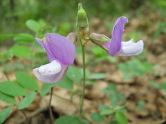
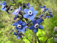
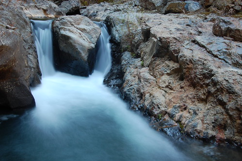
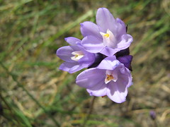
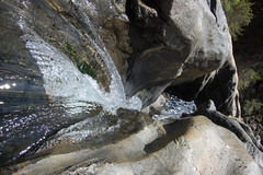
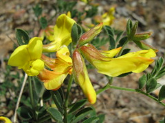
But right away we saw promising signs. The wildflowers were there, alright, as we spotted a shrub with bright yellow flowers (Scotch broom?) and and several tiny little blue flowers with white centers right near the trailhead. And we were barely started when we came across Kennebec Creek and a sign for a waterfall. Rounding a corner, we found the stream flowing across a smooth section of granite, with a small horsetail waterfall above it, and a few clumps of tiny pink flowers on the banks of the creek below.

20080420_3196

After the obligatory photos, we started off and immediately encountered some deep red flowers. Soon the trail joined an old road grade from gold mining days, which heads down to Illinois Crossing. Erik kept pointing out plants that he thought looked like poison oak here. Some people do not develop a rash even if they rub against poison oak. Me, I am very sensitive to it, and don't even need to touch it. The oil that causes rashes can be borne on the wind. I've resigned myself to the fact that I'm going to get poison oak and itch for three weeks, and I don't worry about it (although I still try to avoid touching anything that vaguely resembles the descriptions I have read).

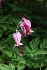
We followed the old road grade only as far as the junction where South Yuba Trail turns off of it to run parallel to the South Yuba River along the north wall of the canyon formed by the river. There were small ups and downs, but the trail is not too challenging, and it is clear and relatively smooth. It might make for a challenging bike ride (bicyclists are allowed on it), but it's easy for hiking. We encountered many more types of wildflowers. Only one was in great abundance, covering large swaths in this area just where the trail begins to follow the river, but there were small clumps of different varieties here and there. Occasionally we could glimpse the river below, seeing bits of white water and emerald pools. Usually we could see the south wall of the canyon, covered with intermixed conifers and deciduous trees.

20080420_3211

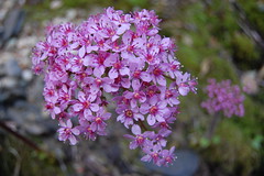
At 1 1/2 miles out we encountered the sign for Overlook Point Picnic Site. We found the picnic tables, but not much of an overlook. Perhaps the vegetation has cut off a view that the area used to have thirty years ago. Along with names, carved in one of the picnic tables was the year 1978, with moss growing in the depression of the carving. Around this area we started to take note of one type of flowering chaparral, fully decked out with small purplish pink flowers, possibly western redbud.
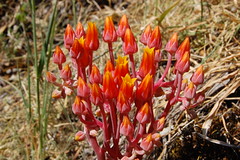
20080420_3310
Dudleya

When we reached Long Point, we had our most spectacular view of the river and its canyon. At this point the river swings to the north on a large horseshoe bend, and the south canyon wall protrudes in a smooth curve further softened by the lush vegetation. Unfortunately, we were on the north side of the canyon looking south, giving poor lighting for a photograph.

20080420_3313

I don't recall if it is right before this, or right after, but a spur trail down to river is very near here, labeled North Canyon Spur. The signage there indicates that it is 3 miles from the trailhead at South Yuba Campground. We pushed on and as the river continued to rise in elevation as we hiked upstream, we finally descended to just above it at the junction with Humbug Trail, 4 1/2 miles out from the campground, where there are two picnic tables, and the second best view of the river on the portion of the South Yuba Trail we covered.

20080420_3239

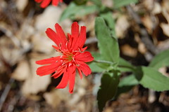
The mercifully short initial portion of Humbug Trail is extremely steep. We huffed and puffed, and right at the top of it found the same deep red flowers we had seen early on the hike, only in better lighting, which made for a good excuse to stop for a moment. The rest of the trail wasn't that bad, but it was certainly more difficult than South Yuba Trail, and required a bit of scrambling over rocks now and then.

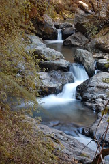
Humbug Trail follows Humbug Creek, named in response to the disappointment of gold miners who were led to believe they would get rich there. Initially the creek is far below the trail, but as we hiked upstream it got closer to the trail, and we began to see many fine small waterfalls. Where it was easy to get down to the creek at a particularly rich area of them, we stopped to take some photos. There are old and rusted iron rods coming out of the granite there, no doubt remains from the gold rush.

20080420_3359

20080420_3242

Erik wanted to attempt to cross the creek here, for a better view of some falls below, but I thought it would be best for us to continue on and see all there was to see, before deciding on what was worth spending time going off trail for. So we kept going.

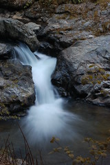
Then we reached a totally unexpected delight, a massive tiered waterfall, with a final plunge of about 25 feet. Humbug Creek Falls, it is, as we found out later from a sign we saw at the end of the trail. I had no idea we would see anything like that.

Above the falls, Humbug Trail enters a more subdued region of forest, without the steep canyon walls, and the creek farther distant. We crossed two small tributary streams, one dry, and the other just a trickle, and passed above a campground. Finally, we came to a gravel road and the trailhead, the start of Humbug Trail for most people, although the end for us. Judging from the map I figured if we turned right and headed east on the road we should soon find a trail over to Malakoff Diggins.

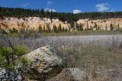
That turned out to be the case. Specifically, we ran into a sign explaining the North Bloomfield Drain Tunnel, a 7,874-foot tunnel 200 feet below. A creek flowing here across orangish mud--orange from all the iron in it--drops down into the tunnel through an old shaft. Another sign here indicated that the trail alongside it provided access to Malakoff Diggins.

We were soon upon them. The diggins are the strangely beautiful aftermath of massive environmental destruction in quest of gold. This was not the romantic scene of thousands of gold miner venturing west, clambering down steep canyon walls and staking claims in the hopes of a finding enough gold to provide them with a comfortable life. This was the work of a massive industry financed by major financiers, designed by engineers, and carried out by legions of low-paid workers.

The walls of the canyon were washed away with high pressure hoses, exposing more and more ore to be processed for gold, and sending dirt and debris downstream in massive amounts. This killed off the fish in the creeks and rivers, and put so much silt in the system downstream that towns had to build high levee walls to contain rivers with ever rising beds. The town of Marysville, built along the banks of the Yuba River near where it flows into the Feather River, now sits below the level of the river, protected from it by a massive levee. Out in the countryside, crops were frequently damaged from floods resulting from all the sediment and tailings washing downstream.

20080420 Malakoff Diggins
Malakoff Diggins

It was this very mine that was the subject of the landmark court decision in 1884 in the case of Woodruff v. North Bloomfield Mining and Gravel Company that would eventually put an end to hydraulic mining in California, although it took many years to fully enforce it. In all the time since, nature has made progress in reclaiming this area, but the massive scar along the edge of the park, caused by work that started more than a century before I was born, will long outlive me.

In all, we hiked about 7 1/2 miles from the campground to Malakoff Diggins. We could have taken a shortcut back, following North Bloomfield Road. But, of course, we wanted to photograph the waterfalls, and I wanted to see some of the different sights along the way in different light.

When we got back to the big waterfall, we took a small side trail over to a granite area between the two tiers of it. We were right at the plunge pool for the smaller upper falls, and on the verge of the larger lower falls. I laid myself out on granite and stuck my camera out to take a photo over the edge.

20080420 The Top of Humbug Creek Falls
The Edge of Humbug Creek Falls

Back on the trail, I could see that it would be possible to get to the base of it via a scramble down the canyon wall for the best photos. But I thought maybe farther down the trail we might have easier access to the creek, and be able to work our way upstream to it. I did find a place where the scramble was easier, and we went to the creek. But I found huge boulders here blocked the view of the falls, and I couldn't find a way to get far enough upstream for that view from there. So I scrambled straight up to the trail again, which left me winded. It was getting to be quite a long and tiring hike, so I didn't have the energy to go back and try the more difficult scramble.

20080420_3294

Instead we went down trail. At one point there is view of a fine series of small falls. I took a long exposure here, using my backpack as a tripod (I stupidly forgot my Gorillapod in the trunk of the car). Erik wanted to scramble down here and take more shots, but I was too exhausted, so I went ahead and took more long exposures of other small waterfalls.

20080420_3296

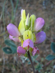
It took Erik a while to catch up to me. He told me that he had been obsessing over some dudleya. As I left him, I saw him paying attention to more dudleya. When I got back to the very steep initial portion of Humbug Trail, I stopped just above it to wait for Erik, who must have once again have found himself obsessed with dudleya. But if something more serious was holding him up, like an injury, I didn't want to have to reclimb that steep portion to look for him, which is why I waited until I saw him before starting down it. Shortly before he appeared, I heard bird noises that vaguely reminded me of turkeys, but they were coming from up in the trees behind me. I was reminded of John Muir's descriptions of all that you can hear and see if you stay still and quiet in the wilderness for a while, and let its denizens return to their daily routine. Erik's approach silenced my unseen companion.

Back on South Yuba Trail we met two mountain bikers at picnic tables. Other than a couple we passed in both directions on Humbug Trail, these were the only people we had seen all day. Later we would encounter one more person, a man jogging past us in the opposite direction.

20080420_3374

Other than more stops for wildflowers on the way back, the highlight was an encounter with a rattlesnake. I saw him up ahead on the trail and thought I would quickly sneak up on him so I could get a good photograph. Thinking on it now, I recall the advice I have read about rattlesnakes--to make lots of noise with your footsteps so that they have plenty of warning and will get out of the way before you can startle them. Quickly sneaking up on a rattlesnake is the last thing you want to do. He was startled and took off while rattling at the same time. I got a lousy photo.

I thought he might have taken off entirely, but as I continued forward, he started rattling again. He was in the rocks at the edge of trail, taking cover. I just kept walking and he stopped rattling. When Erik came along I warned him that there was an angry rattlesnake in the rocks that would rattle at him as he passed. He kept asking me "Where?" I kept repeating "In the rocks," while pointing at a pile of rocks. Erik seemed quite nervous and when the snake started to rattle he momentarily stopped and looked to the side. I told him to keep moving, and soon he was past and the snake stopped his noisemaking.

Being on fairly easy trail again, we were able to recover and make better time than I expected coming back, which allowed the leisure of a few more wildflower photographs. I waited for Erik at a split in the trail at the end--one way leading back to the campground, the other leading to the parking for day users. While waiting I heard rustling, and looked down to see a quivering mouse trying to burrow under leaves to hide from me. When it was finally out of sight the rustling stopped.

Despite making better time on the final portion than I expected, it still took us a full 8 1/2 hours to complete the hike. Even though it was a cool day, I went through all of the water I brought with me.

20080420_3338

Today, the day after, my legs don't feel too bad. Erik was right about the poison oak, however. I've already developed rashes in several areas, and my past experience leads me to believe it is going to get a lot worse as the week goes along.

Monday, April 7, 2008

Auburn State Recreation Area: Foresthill Divide Loop Trail

I wasn't really committed to hiking on this particular day, until after I had breakfast with two photographer friends. I chose a vintage diner for us to eat at and had a traditional "Hearty Breakfast"--and they weren't kidding about the hearty part. Two sausage links, two slices of bacon, two eggs, and two biscuits drowned in an ocean of gravy. After that meal, I figured I needed to hike 10 miles, or start shopping for clothes in a larger size.

20080406 Hearty Breakfast #4
Hearty Breakfast #4

So I took off for a conveniently close hike--35 miles to the West Trailhead from my apartment. The close proximity of this trail to civilization is a major convenience, but it's also one of the liabilities of it, as should become clear in my description.

Just outside of the old gold rush town of Auburn, the Auburn State Recreation Area includes the scenic canyons of the North Fork American River and Middle Fork American River, and the confluence of those two rivers. It's at the start of the foothills for the Sierra Nevada, so there are hikes with some climbing to do, but it is still at a low elevation. That means you can hike there in winter, but in summer it is generally hot, dry, and dusty. Early spring is about the best time to go, before it is too warm, and while the wildflowers are in bloom.

Seeing as how it was a nice day in early spring, a lot of people chose to get out on the trails the same day I did. The designated parking spots at the trailhead were all full, and there were a number of us who squeezed our vehicles into unmarked areas off the road.

From the West Trailhead, it is actually a .5 mile hike to the loop trail, which is 8.2 miles long. So starting and ending from there makes it a 9.2-mile hike. This short spur parallels Foresthill Road, and is not out of sight or earshot from it, although a lovely meadow dotted with gnarled oak trees separates the two.

The directions from the park's website said to take a right at the fork signed for Drivers Flat, but there is another fork before that. I took the lesser traveled right fork just to see where it led. It took me a short distance to a gate for Mammoth Bar OHV road, which appeared to head down steeply and roughly to Middle Fork American River. Getting back on the loop, I soon hit the Drivers Flat sign, and headed right.

It's a multi-use trail, and all along it were mountain bikers and the occasional steaming piece of evidence that horses had been there (although I didn't see any equestrians). Cyclists coming the other direction are supposed to yield to hikers, and 3 actually did. Cyclists going the same directions as hikers are supposed to warn them, let them know which side they will be passing on, and let them know how many more cyclists are right behind them. Many did this, but more did not. I spent much of the hike along, or just off of, the edge of the trail, listening for the sounds of bicycles behind me.

At one point I spotted this unusual bug, subsequently identified for me as a Jerusalem cricket, aka potato bug. I think one of its legs was damaged. It kept falling over, and then walking in circles after righting itself.

20080406_2795

At 1 mile from the trailhead I hit an unsigned spur trail mentioned in the trail description from the park's website. The spur, which out and back adds .8 miles to the length of the hike, leads out to a point with better views of the Middle Fork American River Canyon. The area was also, on this day, covered with large areas of densely packed wildflowers. There were many tall, dark, and handsome butterflies at work there, making hot, sticky love to wanton flowers, lasciviously painted in showy colors.

20080406_2743

Back on the main trail, I passed through chaparral composed largely of manzanita. At some point I was supposed to have a great view to my right, but I didn't see it. I think it may have been at the top of a climb where there were a number of cyclists off the edge of the trail resting. I didn't look around there, but kept on hiking. After coming down from that high point, I saw four wild turkeys a ways off the trail--I thought about going over there, to see how close I could get, but there was a man near there resting under a tree and watching the turkeys. I didn't want to spoil his show by frightening them off.

At three miles in I crossed a bridge, used as a reference point in the trail description. But after that things got more confusing. The trail reached a dirt road, where a sign used to indicate which way to go, but was just lying on the ground. However, the bicycle tracks made it pretty clear which way to go. I passed by small concrete slab with an old rusting hunk of metal on it.

Then eventually I came to an old, crumbling, paved road. I took it to be Drivers Flat Road, mentioned in the trail description. The directions said to continue along the trail across this road, or turn left on it. Either way was to take me to Foresthill Road, where I would cross to a parking lot for the East Trailhead. While I was studying my map and directions, a woman on a bicycle who had lost her brakes rode up and asked for help. When I shared my information with her, she headed left on the road, and not seeing trail ahead, I followed her.

We came up to a major road in use--which initially I took to be Foresthill Road. But I could find no parking lot or trailhead. I thought maybe this was Drivers Flat Road, and the old abandoned road had not been mentioned in the trail description. I started heading down it looking for it to intersect Foresthill Road. But quite a ways down I had not come to an intersection, a parking lot, or a trailhead. Instead I saw a sign for Upper Lake Clementine Road, which confused me, as on my map that indicated I was much close to my starting point that I expected to be.

Not at all sure where I was and if I was headed in a direction that would get me back to my car, I returned to the abandoned road, adding at least another mile to my hike. On the way back I could see that to the right of where I had reached the road there was trail leading off of it again, so I took this.

Eventually, I came out at a parking lot and a sign for Ruck-a-Chucky Campground. Nothing here seem to fit the trail description, but as I figured it out later, Drivers Flat Road leads from Foresthill Road down to this parking area. The old road, now blocked off by a gate, then heads back to where I had come from until it hits Foresthill Road, just below and embankment. Although the trail description says you can head across Drivers Flat Road, or just take a left and follow it, this is inaccurate. You should go straight ahead if you want to follow the road--turning left takes you the opposite direction of the East Trailhead. And the continuation of the trail is on the other side of the parking area, next to some green trash containers.

Back on trail again, I was disappointed to find that the trail just led a little ways off from the road and parking lot, and then doubled back on the road. This is typical of the whole loop--you start to leave the road and road noise, but never get too far away, and you keep returning to it.

At the end of this part of the trail, I scampered across Foresthill Road during a break in traffic, and started from the East Trailhead, passing a picnic table near the parking area.

This portion of the trail runs along the upper edge of the North Fork American River Canyon. I've hiked many of the trails along the wild and scenic North Fork American River farther up in the mountains, and enjoyed its isolation and beauty--well protected by steep canyon walls that make it a challenge to access. But on this trail I only caught glimpses of it a couple of times through the trees from far above.

20080406_2823

I encountered fewer bicyclists on this portion of the hike, so I spent more time taking photos of wildflowers--not having to worry as much about getting out of the way. The trail description said this portion was largely unshaded, but I didn't find that to be the case. When it was shaded, and the sun was behind the clouds, and I wasn't climbing, it was a little chilly.

20080406_2804

At one point I reached an area where I could see Foresthill Road again, and I recognized the portion as the one I had been walking along while lost earlier. Had I known, I could have just gone 50 yards across the meadow and joined with the trail on the return portion of the loop, but then I would have missed out on quite a bit of hiking, and wouldn't have fully worked off my biscuits and gravy.

Shortly after that, 2.5 miles from the East Trailhead, according the the description, the trail crosses Upper Lake Clementine Road. It took me longer to reach there than I was expecting, so I thought I still had quite a bit of hiking ahead of me, but this turned out not to be the case. Pretty soon I was back at a meadow next to Foresthill Road again. The trail leads up to the road, then I had to cross it and get on a short trail that leads back to the signed junction for Drivers Flat and the short spur back to the parking lot, which was visible a ways down the road.

All added up, I hiked at least 11 miles, and didn't eat anything between 9 a.m. and 5 p.m. that day, so hopefully I took care of breakfast.

Wednesday, April 2, 2008

Index: Culture

Roadside

Highway 99: Pollardville & the Chicken Kitchen
Sacramento Googie
U.S. 40: North Sacramento's Del Paso Boulevard
U.S. 40: Sacramento's Auburn Boulevard
U.S. 40: West Sacramento's Motel Row
U.S. 50: Sacramento's Folsom Boulevard
U.S. 99: Oak Park's Broadway
U.S. 395: Road Trip
Vintage Neon Signs: Fresno
Vintage Neon Signs: Marysville & Yuba City
Vintage Neon Signs: Sacramento
Vintage Neon Signs: Stockton
Lost Neon Sign: Martinez's State Theatre
Lost Neon Sign: Sacramento's Philipp's Bakery

Restaurants

East Bay: Classic Restaurants
Sacramento Area Barbecue Joints
Sacramento Area Classic Burger Joints
Sacramento Area Pizzerias
Sacramento's Vintage Diners

Sacramento Tourist

Sacramento: Aerospace Museum of California
Sacramento: Towe Auto Museum

Wine Country Traveler

Historic Pope Valley
Napa's Oxbow Market
 
Fairs and Carnivals

California's Carnival and Fair Foods
California State Fair
Sacramento County Fair

Index: Nature

The Coast

Marin County: China Camp State Park
Marin County: Steep Ravine and Stairstep Falls
Mendocino Coast: Russian Gulch State Park
Mendocino Coast: Van Damme State Park
Mt. Diablo Summit from Mitchell Canyon Road
Mt. Tamalpais State Park & Muir Woods
Mt. Tamalpais Watershed: Cataract Falls
Mt. Tamalpais Watershed: Two Lakes Loop
Point Reyes: Alamere Falls
Point Reyes: Alamere Falls Revisited
Point Reyes: Arch Rock Revisited
Point Reyes: Bear Valley & Arch Rock
Point Reyes: Drakes Head & Sunset Beach
Point Reyes: Five Brooks to Alamere Falls
Point Reyes: Lighthouse & Chimney Rock
Point Reyes: Limantour Spit & Bucklin Trail
Point Reyes: Mt. Wittenberg & Woodward Valley
Point Reyes: Muddy Hollow & Drakes Head
Point Reyes: Ridge Trail
Point Reyes: Rift Zone Trail
Point Reyes: Sculptured Beach
Point Reyes: Tomales Point & McClures Beach
Point Reyes: Woodward Valley & Sculptured Beach
Sonoma Coast State Beach

El Dorado National Forest
(Additional hikes in El Dorado National Forest can be found below under Lake Tahoe Basin.)

El Dorado National Forest: Barrett & Lawrence Lakes
El Dorado National Forest: Carson Pass to Emigrant Lake
El Dorado National Forest: Echo Lakes to Lake of the Woods
El Dorado National Forest: Emigrant Lake Trail
El Dorado National Forest: Grouse & Hemlock Lake Trail
El Dorado National Forest: Highland Trail to Forni Lake
El Dorado National Forest: Lyons Creek Trail
El Dorado National Forest: Lyons Creek Trail in Snow
El Dorado National Forest: PCT to Showers Lake
El Dorado National Forest: Pearl Lake
El Dorado National Forest: Pyramid Creek Loop & Horsetail Falls
El Dorado National Forest: Pyramid Peak
El Dorado National Forest: Ralston Peak
El Dorado National Forest: Silver Lake to Granite & Hidden Lakes
El Dorado National Forest: Twins & Island Lakes Trail
El Dorado National Forest: Tyler Lake Trail
El Dorado National Forest: Winnemucca & Round Top Lakes

Lake Tahoe Basin

Lake Tahoe Basin: Bayview Trail to Middle Velma Lake
Lake Tahoe Basin Dardanelles Lake
Lake Tahoe Basin: Eagle Falls to Velma Lakes
Lake Tahoe Basin: Eagle Point to Emerald Point
Lake Tahoe Basin: Ellis Peak & Ellis Lake
Lake Tahoe Basin: Glen Alpine Springs to Half Moon Lake
Lake Tahoe Basin: Glen Alpine Springs to Lake Aloha
Lake Tahoe Basin: Meeks Bay to Rubicon Lake
Lake Tahoe Basin: Meeks Bay to Stony Ridge Lake
Lake Tahoe Basin: Mt. Tallac Trail
Lake Tahoe Basin: Rubicon Point to Emerald Bay

Tahoe National Forest
(Additional hikes in Tahoe National Forest can be found above in Lake Tahoe Basin.)

Tahoe National Forest: Bearcroft Trail
Tahoe National Forest: Heath Falls
Tahoe National Forest: Loch Leven Trail
Tahoe National Forest: Mumford Bar Trail
Tahoe National Forest: Penner Lake
Tahoe National Forest: Warren Lake Trail

Other

Auburn State Recreation Area: Foresthill Divide Loop
Bullards Bar Reservoir
Calaveras Big Trees State Park
Mount St. Helena
Napa County: Skyline Wilderness Park
Plumas National Forest: Feather Falls Trail
Rancho Seco: Howard Ranch Trail
Santa Cruz Mountains: Butano State Park
Solano County: Stebbins Cold Canyon Reserve
South Yuba Trail/Humbug Trail/Malakoff Diggins
South Yuba Trail: Purdon Crossing to Edwards Crossing
Spenceville Wildlife Area
Stanislaus National Forest: Kennedy Meadows to Kennedy Lake
Stevens Trail
Yosemite National Park: Upper Yosemite Falls Trail

Other Northern California Hiking Links

Trailspotting
waterfallswest.com
Kevin's Hiking Page