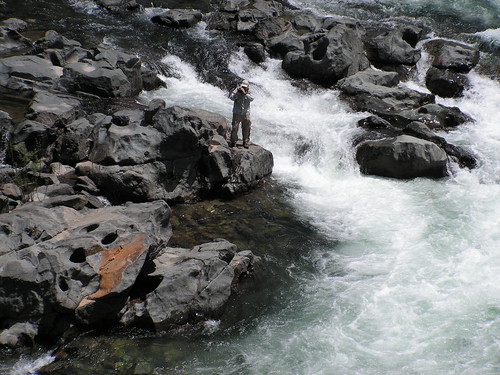
Me in Action at Edwards Crossing
With Labor Day behind us, my hiking buddy Erik felt like it was summer and was anxious to visit the High Sierra this weekend, but I vetoed that, as May 31st is still a little early. I thought the wildflower blooms ought to still be strong in the foothills, so I suggested that instead we return to the South Yuba River Recreation Area, where we had such a lovely hike last year--although I paid for that one afterwards with severe poison ivy rashes that sent me to the doctor for a prescription.
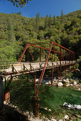
The South Yuba River Recreation Area is composed of a patchwork of Bureau of Land Management property and land that is part of South Yuba River State Park. It stretches from the historic covered bridge at Bridgeport (photo) to Tahoe National Forest, and is contiguous with Malakoff Diggins State Historic Park, presenting plenty of opportunities for hiking, camping, swimming, and gold mining. Yes, limited forms of gold mining are allowed along the stretches of river running through Bureau of Land Management property (but not in the state parks).
Our hike was along the South Yuba River National Trail from one historic bridge, Purdon Crossing, to the next one upstream, Edwards Crossing. To get to Purdon Crossing, we drove to Nevada City, then took North Bloomfield Rd. to the junction with Lake Vera-Purdon Rd., and then took that winding road past Lake Vera to Purdon Crossing. The last stretch was mostly unpaved, and heavily rutted in parts. It was slow going. It's paved road all the way to Edwards Crossing, but I chose to start at Purdon just so we would have more uphill hiking on the way out, and then could have it a little easier on the way back. But there isn't a great deal of difference in elevation between the two river crossings.
Purdon Crossing
We parked just short of Purdon Crossing and the short turnoff to the parking area for the trailhead. That wasn't intentional--I didn't realize there was a larger parking area--but it did afford us the opportunity of viewing and photographing the historic bridge.
According to this interesting website, the bridge dates from 1895 and "is the only remaining half-through metal truss system bridge west of the Rocky Mountains." The "half-through" part I believe refers to the fact that the deck of the bridge is set at the vertical midpoint of the metal truss.
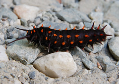
Caterpillar
We hiked up the turnoff to the parking area (no facilities), which had a caterpillar crawling across that we stopped to photograph. From there we were presented with two trail choices, the signed trail to Edwards Crossing, indicating a distance of 4.5 miles, which was quite a bit longer than what I had told Erik from looking at my map, and also a much wider path--maybe an old road--that keeps low along the river. This leads to several swimming spots and a campsite.
We took the South Yuba National Trail, which climbs up the side of the canyon on a narrow path that in the early going had lots of vegetation spilling onto it. Erik loves that, as opposed to the wide open trails, but it was making me nervous after last year's miserable experience with poison oak. And as Erik pointed out, there sure were a lot of plants with leaves in groups of three.
The trail climbs quite a bit above the river, and while we could always hear the South Yuba flowing, we couldn't always see it, although we would catch glimpses now and then. The vegetation was thick, and being on the south side of the canyon, out of direct sunlight for most of the day, it was still quite damp. I'm sure this late in the season that the exposed north side of the canyon was mostly dry. It was also a warm day, with a forecast of 85 degrees for Nevada City, and the combination of warmth and moisture meant there were plenty of mosquitoes, making me doubly glad (in addition to the protection from poison oak) that I had worn pants and long-sleeves.
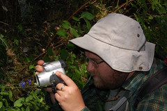
Erik Stalking Wildflowers
The wildflower display was pretty strong. In hikes past, I would have at least taken a quick photo of each one so that I could have tried to identify them for my hike report, but I'm getting pretty lazy about stopping to photograph wildflowers anymore. We did pause to photograph a few, though.
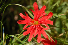
Indian Pink
There were some use trails down to the river at points, and some of these were quite well worn--so much that I would hesitate, wondering which was the main trail. But we just always took the upper trail until reaching the clearly signed junction with the trail coming down from Round Mountain. It didn't have mileages marked, but I would guess that the junction is 2 miles from Purdon Crossing and 2.5 miles from Edwards Crossing.
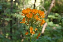
More Wildflowers
Between that junction and Edwards Crossing, we hit a rocky section that was more exposed, and consequently had better views of the river. We saw a group of 4 kayakers floating below us. At one point, the trail was eroded and we had to be careful stepping over it, as there was a steep drop off at that point.
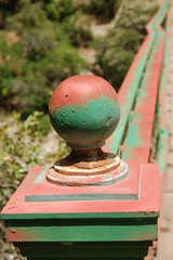
Detail, Edwards Crossing
Eventually we could see the next bridge and the trail started heading down to it. At the trailhead there were many vehicles parked, and a pit toilet. I headed straight across the bridge and climbed down on the rocks to the river to get a picture of the bridge while the light was still coming a little bit from the side, although it was mostly from overhead at that point, and I wasn't too pleased with my shots. Erik took a photo of me in action from the deck of the bridge. According to the aforementioned website, the bridge at Edwards Crossing was built in 1904.
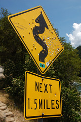
Sign at Edwards Crossing
After making use of the facilities, we started back. This was not anywhere near a difficult hike in comparison to many of the others we have done, but I was anxious to get back to the car, and not looking forward to the long hike. It had been over a month since my last hike, which is an unusually long stretch for me. It was a warm day and I was sweating a lot. And I hadn't told Erik (still haven't, until he reads this), but I was under the weather, and had put my cell phone by my bed the night before so I could call him first thing in the morning to cancel the hike, if need be. I was starting to think that maybe I should have.
But while I felt drained, I just kept plodding on, one step after another until we made it to the car. I didn't stop for photos on the way back, and after carrying the camera in my hand for a while, because the weight on my neck was causing discomfort, I finally tucked the camera away in my backpack. Erik got some interesting shots though, including one of two lizards giving a third lizard a hickey. Either that or they were trying to bite its head off. Peculiar.
So, a question left unanswered at the beginning--with all of that poison oak in the area, and the precautions I took against it, did I end up getting poison oak? Of course. I always get poison oak. This is just the third time this year, after six times last year, but that's mainly due to the fact that I have been hiking less. Fortunately, it appears to be confined to a small patch on my left arm near my wrist, unlike last year's South Yuba River hike, when it was all over me, and I was miserable.
But my next hike is going to be in the Sierras, where Erik wanted to go this time--there's no poison oak above 4,000 feet.
No comments:
Post a Comment