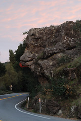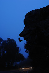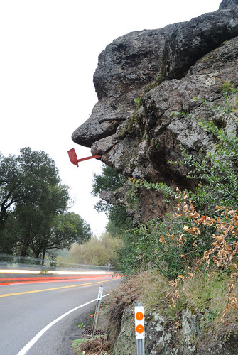
Recently at the Friends of the Sacramento Library's Book Den I picked up several local history history books on the cheap, and in one, There's a Little Spot I Know (by Jim Babcock, published by the Sacramento Bee in 1985), there is a photo of a “well-known Napa County landmark” described as being “10 miles east of Napa” on Monticello Road. It's a rock formation overhanging that highway that resembles an old man. To add to the resemblance, a piece of metal in the shape of a pipe has been added.
Having moved to Napa five months earlier, I wondered about not having seen or heard anything of the supposedly well-known landmark. I did several searches on Flickr, but didn't find any photos of it. Google searches turned up several references, but mostly historical. It has been referred to variously as Old Man with a Pipe, Old Man Rock, and the Old Irishman. One piece from the Napa Valley Register on a postcard collector in September of 2008 mentioned that he had a card with a photo of the rock formation “back when the stone nose was longer,” the only indication I had that the rock formation could still be seen along Monticello Road.
As soon as I had a decent opportunity, I set off in search of Old Man Rock, as I have chosen to call it. Monticello Road apparently originally led from Napa to the town of Monticello. The original town site now lies beneath the waters of Lake Berryessa, formed by the construction of the Monticello Dam beginning in 1953. Apparently photographers Dorothy Lange and Pirkle Jones documented the abandonment of the town in the book Death of a Valley (thanks Wikipedia, looking forward to checking it out).
Ten miles outside of Napa was a vague reference to go on, considering that I don't know what the border of the city was at the time that reference was made, but luckily the rock formation proved easy to spot. Monticello Road begins at the junction of Trancas Street, a main east-west thoroughfare on the north end of town, and the Silverado Trail, one of the two highways that runs north-south through Napa Valley. Heading out (northwest) on Monticello Rd., CA-121, Old Man Rock is to be found just 2.5 miles past the stoplight at the junction with Atlas Peak Road (the turn off for the Silverado Country Club).
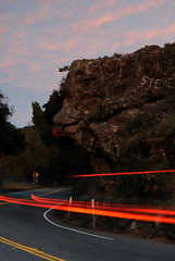
There is a turnout immediately before Old Man Rock, but it is to allow faster vehicles to pass only, and there are “no parking” signs. There are several private drives nearby. I managed to park my subcompact off the edge of the road just past one of those. There's not much room for walking along the side of the road, or setting up a tripod either. My tripod seemed in constant danger of being swiped by cars coming down around the curve behind the Old Man, but I felt like I would safely be able to scramble out of the way. The best place to photograph the rock from would be the middle of the road, but that would be absurdly dangerous.
According to the Napa County book in the Postcard History Series from Arcadia Publishing, the pipe was added in 1911. No word on who added it.