Low expectations were the order of the day as Erik and I headed out for another hike at Point Reyes National Seashore. The conditions weren't quite right for most of the more dramatic hikes there—not a lot of recent rain for Alamere Falls to be at full flow, and the low tide was not going to be particularly low, so no point in visiting the tide pool areas. So I just looked at the map and decided on a main hike that would cover some trail I haven't been on before—part of my quest to hike every last mile of official trail (whether still maintained or not) in the national park. But before we set off on the main hike, I planned for us to do a short hike down Limantour Spit. Limantour Spit is a wide sand bar that stretches about 2 ½ miles from the shore out towards the actual point and Chimney Rock. On one side is the wide-open ocean, and on the other side is a small inlet of ocean water that divides the spit from the cliffs of the mainland, including Drakes Head. In between the cliffs are further inlets—the first (from east to west) very minor, the second forming Estero de Limantour, and the third forming Drakes Estero, large enough to have four named bays branching off of it.
There's a one-mile trail going down the center of Limantour Spit on the map, so I figured we would hike 2 miles out and back before heading off for our main hike. Only I hadn't looked at the map that closely when planning. The trail goes less than 1/2 the length of the spit, and goes along the top of a sand dune. We walked right past the start of the trail, headed down the beach, and kept going past the end of the trail and the end of the sand dune.
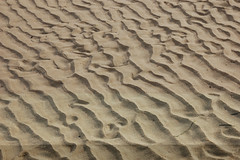
The initial portion of the hike was beautiful, of course, with a wide expanse of beach stretching on seemingly forever, and the waves gently crashing. But it got more interesting once we passed the end of the sand dune on our right. Then came a series of smaller sand dunes separated by open gullies through which we could see the muddy low areas on the north side of the spit exposed by the receding tide and backed by the cliffs on the other side of the inlet that separates the spit from the mainland. We walked along the edge of this wet tidal area, enjoying the views of the cliffs and the esteros.
We hiked out more than 2 miles, and since I had only planned on hiking out 1 mile, it took us longer than I had planned. I would have liked to have gone all the way to the very end of the spit, and we weren't that far from it. I know people go out there, because I've seen them from Sunset Beach, on the mainland. But we were at the point of low tide, and not having been out there before, I wanted us to get back without giving the tide a chance to rise any higher than it had been when we set out.
Before returning, I climbed up the last sand dune to check out the view, and immediately noticed a bunch of wood and cords that appeared to be part of a sailing vessel. I went over to check it out, and discovered a shelter had been built into the side of the sand dune out of various items that had been washed ashore, and a couple of lawn chairs that may have been left behind. Before it a bench and table were set up. The table was covered with a collection sea shells. No sign of the creator of this remote retreat.
We headed back along the beach, and before long met up with our footprints left on the way out. When we got back to the long sand dune, we climbed it, and followed what seemed to be a faint use trail, until it brought us to a wider path that must have been the official trail shown on the map. It appears that even at high tide this trail is well above the water line, so we could have made it to the end of the spit and still made it back with plenty of margin for error. The highlight of this portion of the hike was spotting two deer.
Back at the car, we drove back on Limantour Road to the trailhead at Muddy Hollow Road, and set out on that dirt road.
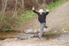
Soon there was a stream to cross, but it was pretty narrow, so I just ran up and leaped across it. Erik generally prefers to slowly step across rocks to cross a stream—rock hopping is the general term, but in Erik's case it is more like rock yoga. But not seeing suitable rocks to step across, he leaped too—and came about one boot length short of making it without splashing.
Past the junction with Bay View Trail, the trail climbed a bit, and Erik pointed out the trees we were passing by: bishop pines. They had pine cones growing straight out of the trunk of the tree, and there were no pine cones to be found on the ground. He told me that they stay on the tree and only open to release their seeds in fire.
We reached a nicely signed junction and started off on Bucklin Trail, which climbs quite a ways to reach Point Reyes Hill at 1,336 feet. Oddly, Point Reyes Hill is 54 feet higher than the peak of Mount Vision, yet only merits the label "hill."

Bucklin Trail turned out to be a real delight. It is well graded and without many ups and downs (which can add a lot of additional climbing beyond the net elevation gain). Much of it was through a young and dense forest of bishop pines, which formed a canopy over the trail. Erik kept commenting on how densely packed these trees were, and when he got home he did some research. This whole area was burned out in the Vision Fire of 1995, and the young trees grow narrow and close together, but as they get larger, 97% of them will die off, and the larger mature trees will be spaced much farther apart.
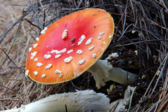
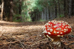
The time of year, the recent weather conditions, and the shade provided by the canopy of trees proved to be ideal conditions for fungi and banana slugs. Over the course of this hike we spotted more banana slugs than we have ever seen on a hike before. But more exciting to me was the profusion of different types of mushrooms. I've never seen anything close to this wide of a variety of mushrooms.
Deer SkeletonGiven the low-light conditions and the need to use a small aperture to get sufficient depth of field in macro shots, I had to shoot long exposures to get decent photographs, and that was just too much work and too time-consuming for me to photograph every variety of interesting mushroom, much less every interesting mushroom.
As we neared the end of 2.3-mile Bucklin Trail we came to a clearing with spectacular views to the west of a large expanse of the park and ocean. Unfortunately, we were looking into the sun and there was a mixture of fog and clouds, so it didn't look like it would make for a compelling photograph, but it was breathtaking to see in person. To the immediate east it was quite the opposite—a large, fenced-off radar installation on top of the hill used for air traffic control. We hiked alongside this until we reached Inverness Ridge Trail.
Inverness Ridge Trail pales in comparison to Bucklin Trail for hiking pleasure, but it looks like it would be a great trail for bicycles. It was wide with lots of ups and downs. At one point there was a narrow, unmarked side trail. We couldn't resist our curiosity and ran up it to see if it led someplace interesting. It kept going and had another unmarked junction, and at that point we decided to turn back and return to the mapped trail. On the map this area appears to be close to the park boundary and private land, so I'm guessing that this trail might have led there. It's not shown on the full park map or the north district hiking map.
From Inverness Ridge Trail we made our way back to Muddy Hollow Road via Drakes View Trail. As we were heading downhill, I expected wide open views of Drakes Head and Limantour Spit, so as to justify the name of the trail. But we had no such views. It resembled Bucklin Trail, only was generally steeper. As we got to the lower portion, it opened up to a more grassy area with a couple of large wooden arch bridges across streams. On this lower portion of trail I spotted four rabbits. Back on Muddy Hollow Road, Erik redeemed himself by clearing the creek with his leap.
In all this main hike added up to 7.1 miles, and we had hiked another 4+ miles out on Limantour Spit in the morning, so I was satisfied with that. I hate to drive such a long distance and do anything less than 10 miles of hiking. There was also quite a bit of climbing for Point Reyes, although not much in comparison to Sierra hikes.
The fact that in all my research of trails to hike in Point Reyes I have never read anything about Bucklin Trail gives an idea of just what a great variety of terrific hikes there are to do at Point Reyes, albeit we may have been very lucky on our timing for the mushrooms and banana slugs. For a day that had started with such low expectations, both Erik and I were thoroughly delighted with our day of hiking.


