The two neighborhoods that I find most fascinating and appealing in Sacramento are the old city of North Sacramento (incorporated into Sacramento in 1964), and the first suburb of Sacramento, Oak Park, which was annexed in 1911. Both have a rich history, long family traditions, and great architecture. Both have also long been problem spots for the city, known mostly for crime and abandoned buildings. For decades developers have spent millions of dollars to lobby politicians to zone undeveloped areas so they could put in strip malls and tract housing ever farther out in the suburbs, while beautiful buildings and houses close to the city center have been allowed to decay, often to the point that they have to be demolished.
Oak Park is such an old neighborhood close to the city center that it is hard to picture it as ever having been on the periphery of the city, but it was at the end of the nineteenth century, when it was developed as Sacramento's first suburb. It was subdivided and lots were sold starting in 1887. It wasn't until the years around 1910, though, that the neighborhood expanded most rapidly, leading to the 1911 annexation.
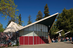
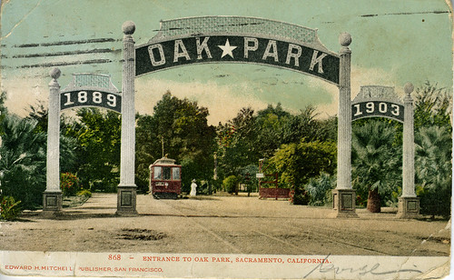
Any piece written on the history of Oak Park has to mention, or at least prominently feature a photo of, two main elements: the Oak Park arch, and Joyland.
The iconic image of Oak Park is the "1889 OAK*PARK 1903" sign backed by a row of palm trees running down the center of the street, and usually with a streetcar in view. I believe, but have not for certain verified, that this was at the trolley terminus on 35th, the "main street" of the community, in front of the Joyland (now McClatchy Park).
Ah Joyland. Joyland was an investment from the streetcar company. Not only did they make money off the amusement park, they made money transporting people from downtown to the park on weekends, when ridership would otherwise be low, because not as many people from Oak Park would be commuting to jobs downtown as on weekdays. In June of 1920, Joyland was extensively damaged by fire, and although some rebuilding was done, the park never fully recovered. In 1927, newspaper heir Valentine McClatchy purchased the park and donated the land to the city, The land now comprises C.K. McClatchy park, named after the Sacramento Bee founder.
Into the 1950s Oak Park still had a prosperous business district. A 1951 article in the Sacramento Union touts the quaintness of the Oak Park shopping district in comparison to the modern chrome and tile shopping center, comparing 35th Street between 4th and 5th Avenues to Main Street in a small town. A photograph accompanying the article shows 4 lanes of traffic, parked cars lining the street, old painted advertisements on the sides of brick buildings, and large neon signs advertising business after business. It is disorienting to me to look at the picture and try to determine where it was taken, as what remains today bears no resemblance whatsoever to the photograph.
At first, the car was a friend to the development of Oak Park. Sacramento Boulevard (now Broadway) carried the Lincoln Highway and later US Route 99 through the heart of Oak Park on the way south through the Central Valley. But the growing popularity of the automobile in the first half of the twentieth century led to people moving farther and farther from the city center, and that trend exploded in the years following World War II. In 1940, 62% of the population of Sacramento County lived within the borders of the city of Sacramento. By 1960, that figure was down to 38%. The middle class abandoned traditional neighborhoods like Oak Park to pursue modern luxuries: extensive ranch houses, large yards, garages and driveways, and easy access to modern drive in markets.
The redevelopment of downtown Sacramento's west end starting in the mid 1950s further hastened the decline of Oak Park. As slum housing downtown was demolished, the former residents looked for new places to live, and as the middle class moved to the suburbs, the working class and poor moved to the neighborhoods they had abandoned. Oak Park and Del Paso Heights particularly attracted the displaced black population, as unlike the rest of the area, there were no racial restrictions on home ownership in these neighborhoods.
In contrast to the rosy picture painted by the 1951 newspaper article, a 1961 report from the City Planning Commission addresses the problems of the business district, and its "general obsolescence" (while that remark was made specifically about businesses along Stockton Boulevard, the phrase nicely sums up the overall tone of the report on the Oak Park business district). In addition to the need to address the deteriorating residences in the area, the plan has two primary remedies: more parking, and a pedestrian mall on 35th Street. I don't know why the pedestrian mall cure was such a popular notion at the time, but it was put into effect--with disastrous results--on K Street in downtown Sacramento and Fulton Street in Fresno. No such effort was put into attempting to save Oak Park's business district.
At the time of the report, the South Sacramento Freeway, which would bypass US Route 99 through the heart of Oak Park, was under construction. This would be another blow for the struggling neighborhood. The freeway opened to traffic on 22 November, 1961. Not only did this create blight right next to a historic residential area, it cut off the business district from wealthy Curtis Park. There were no handy exits for the business district, as it was too close to the enormous interchange--today's ironically named Oak Park Interchange--between the South Sacramento Freeway, the 29th-30th Street Freeway (completed ca. 1966), the W-X Street Freeway (late 1960s), and the El Dorado Freeway (US 50, ca. 1970).
As the neighborhood became more ethnically diverse and declined in prosperity in the late 1960s, tensions between residents and police increased, and finally exploded in the Oak Park Riot of 1969. In the week following, several more businesses closed their doors and moved to the suburbs and the transformation of the prosperous "town within a city" described in that 1951 Sacramento Union article into one of the city's worst neighborhoods, with a reputation even worse than the reality, was complete.
NBA star Kevin Johnson grew up in Oak Park, and did not forget it. He founded the non-profit St. HOPE Development Co. and operates the for-profit Kynship Development, and has bought many properties in hopes of rehabilitating the neighborhood. The one real success story so far has been the south side of Broadway, where 3rd Ave., 35th St., and Broadway converge, the 40 Acres Complex. The Guild Theatre has been restored, and there's a bookstore, an art gallery, and a Starbucks. I'm no fan of Starbucks, but if they're helping to save a historic building in a historic neighborhood, then more power to them.
Not much has been done on the other properties, unfortunately, and the city was forcing the issue. A Sacramento Bee article on Johnson's company's struggles that mentioned plans to demolish two historic buildings resulted in a lot of pressure on Johnson to save them, and efforts have been made to establish historic districts in Oak Park that would make it more difficult to demolish such buildings. Of course, now that he has been elected mayor, resistance from the city may decline.
So, that brings us up to date on the history of Sacramento's Oak Park, now let us turn our attention to the route of old US 99 and the businesses, buildings, and signs that sprouted up alongside of it.
Before the freeways, US 99, headed south from the junction with US 40 in downtown Sacramento down 15th or 16th (16th was originally two-way and was the route of 99, later it became one-way north bound and 15th carried south-bound traffic). Upon reaching Broadway (or Y, as Broadway was originally named) at the Tower Theatre building, 99 turned east. At Alhambra, now reached just after passing under the freeway, the street divides. US 99 diverted at an angle southeast onto Sacramento Boulevard (originally Sacramento Avenue, now Broadway), entering the heart of Oak Park. At a Y, the current route of Broadway follows the old 99 route from Martin Luther King Boulevard (formerly the continuation of Sacramento Boulevard) to Stockton Boulevard (formerly Upper Stockton Road) along what was called Leland Stanford Avenue, but is now Broadway. From Leland Stanford Ave./Broadway, 99 headed down Stockton Boulevard towards Galt, Lodi, and Stockton. U.S. 50 also shared this route for many years on its way to the Bay Area via Altamont Pass, and the Lincoln Highway, which preceded both of these highways, most likely followed this route, or one very close to it.
Instead of bypassing it on the South Sacramento Freeway, which is now CA 99 (as there is no more US 99), let's take a more leisurely journey down what remains on the historic highway route, beginning at Broadway and Alhambra, passing through the heart of Oak Park, and finishing at Broadway and Stockton Boulevard.
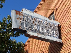
3121-3123 Broadway, 2529 Sacramento Blvd
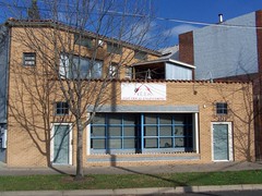
A typical example of the brick buildings of Oak Park. Several cleaners have done business here, at least as early as 1933.
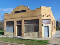
3125-3133 Broadway, 2547 Sacramento Blvd
Furniture and washing machines you could buy here over the years. Dates back to at least 1927.
2549 32nd St
Immaculate Conception Catholic Church
3300 Broadway, 2660 Sacramento Blvd
This was Leigh A. Paine's Drug Store, built around 1927 or 1928. By 1949, it was the office of lawyer John Harby Paine, who is listed there in 1996. Last year it was in the process of being refurbished.
3322 Broadway, 2710/2714 Sacramento Boulevard
A bicycle store, a dairy store, a liquor store, and then a pet store with oddly varying names: Pet & Pigeon Center, Pet & Poodle Center, Pet & Puppy Center. Then vacant for many years before becoming a studio.
3324/3326/3328 Broadway, 2718/2722/2726 Sacramento Blvd
There's a sign still visible at 3324 for Blakely's Beauty Salon, and before that it was Venezuela's Beauty Salon since at least 1965, but was a series of shops before that. Next door, 3326 was a beauty salon in the earlier days--the 1930s and 1940s, before being put to various uses. 3328 was a barber shop from at least 1932-1970, but has been vacant a lot since then.
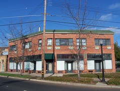
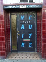
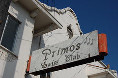
3402/3406 Broadway, 2758/2760 Sacramento Blvd
The Ogg Building built in 1910 as a post office, grocery store, and library branch--and that was just the ground floor! Upstairs there were 2 apartments and 2 doctors' offices. 3406 has had the most continuity, housing Bill & Joe's Lunch from the 1930s to 1950s, and then the Swiss Club from around 1954 up to the millenium. Primo's Swiss Club closed there in 2004, and it has been vacant since.
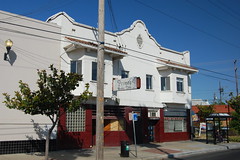
3418 Broadway, 2778 Sacramento Blvd
The basic structure was complete around October of 1914, hence the "1914" on the side of the building, but it didn't open as Sacramento Bank until January of 1915. Then it has a dome over the entrance. It was a Bank of America in the 1930s, 40s, and 50s, before being place by a less substantial, but more modern, Bank of America down the street. In the 1960s and 1970s it sat vacant. In the 1980s and into the early 90s, it was often used as a church. It was refurbished and opened as the present US Bank on October 11, 1995.
3456 3rd Ave
Opened in 1925 or 1926 as the Hotel Woodruff, and was still listed as that in 1980. This is one of the Kevin Johnson refurbished buildings.
2828/2830 35th St.
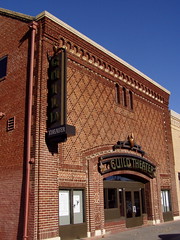
The exact origins of this place have been hard to track down. A book on Sacramento theaters says this was the Victor Theatre from 1915-1926, the Oak Park Theatre from 1931 to 1947, and the Guild Theatre from 1952-1969. The Sacramento Bee says that it was the Victor Theatre as early as 1907. There is a Victor Theatre listed at 2812 35th St. in 1919, and one listed at 2830 in 1925, but there is no Victor Theatre listed in Sacramento in the November 1923 telephone directory. According to an old advertisement in the Sacramento Bee, it opened as the Oak Park Theatre on October 31, 1931 and is still listed as that in the 1949 Polk city directory, despite the fact that the book says it closed 2 years earlier.
So I'm not quite sure about the Victor Theatre origins, but it was the Oak Park Theatre in the 1930s and 1940s, and after being closed for a couple of years, reopened as Sacramento's first art house theater, the Guild, for the 1950s and 1960s. Subsequently it was used as a church, and even had a huge baptismal fount installed. I then found an article about volunteers cleaning it up and working to restore it--but I'm not sure what came of that. Kevin Johnson's group then bought it and it is now open again at the Guild Theatre, although performance there are not too frequent.
3501 3rd Avenue
The Gostic Brothers built this structure for their meat market around 1912, and it continued as a meat market through the 1940s before becoming a thrift store, and then sitting vacant.
3503 Broadway, 2801 Sacramento Blvd
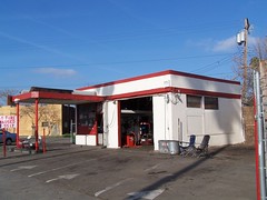
Six Day Tires was originally a Shell Station.
3514 Broadway
The Main Event Beauty Complex was another grocery store in the 1940s and 1950s.
3519 Broadway, 2833 Sacramento Blvd
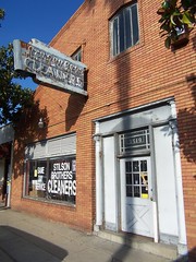
Jasper P. Stilson was presser in 1921 & a cleaner for Spurgeon's in 1922, but the 1923 city directory shows the Stilson Bros. in business as cleaners at this address.
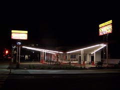
3621 Broadway
I believe the Paris Bakery building dates from the mid to late 1960s, when it was the Artic Circle Drive In.
Martin Luther King Jr. Blvd (formerly Sacramento Blvd) intersects, originally Leland Stanford Ave continued continued to Stockton Blvd.
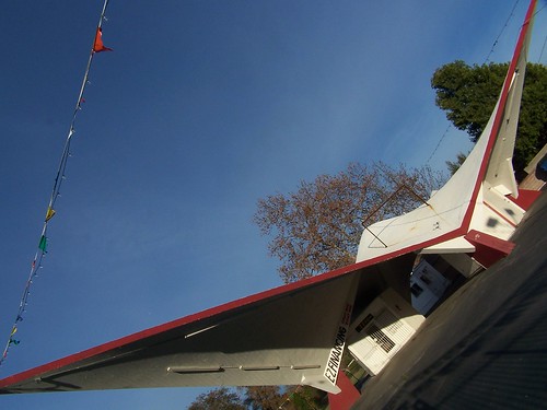
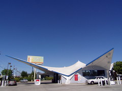
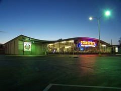
3820 Broadway
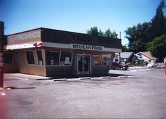
Photo by illtakeyourphoto!
Karl's Drive-In opened in the early 1950s, then became Joe's Drive Inn, before more than a 30 year run as Taco Rico.
3930 Broadway
When not vacant, an appliance store since the early1950s.
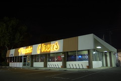
4307 Broadway
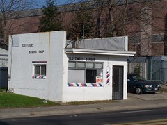
The aptly named Old Timers Barber Shop.