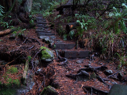
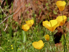
Just about an 80 mile drive northeast of Sacramento lies Carr Lake. It is a short walk to the lake from the parking area, there is a PG&E campground there, and trails head off from this spot to a large number of small mountain lakes. I would be up there quite regularly, if it weren't for the last section of dirt road you have to take to get there. I did okay on it in my little Metro--certainly it wasn't as bad as the road from Soda Springs to Cascade Lakes I took for my hike to Heath Falls--but I'm not planning to make that drive in the same car again.
My destination was Penner Lake, just 3.2 miles away (as listed on trail signs and in Tahoe Sierra, California Hiking indicates it is even closer, but my old edition is often inaccurate). It should have been an easy hike for me, except that I was sick.
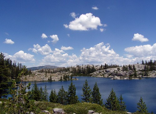
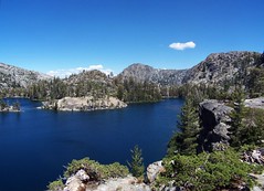
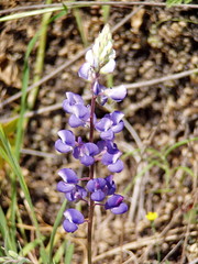
I walked pass tiny Carr Lake on the right following the Round Lake Trail. Then the trail follows a long section of the shoreline of large Feeley Lake on the left. When I came to a pretty little pond on the left I was supposed to make a left turn on the Crooked Lakes Trail, but I proceeded on Round Lake Trail on the south side of Island Lake a short ways before realizing my mistake.
Feeley Lake
I went back and crossed the ridge of land that separates Island Lake from the pond that doesn't rate a name. There were plenty of people throughout this area enjoying these readily accessible lakes. There were fewer along the rest of the hike, which involved more climbing.
The trail then passes by Crooked Lakes, but I don't recall seeing much of them from the trail other than a pond. The map indicates that there is a large number of ponds and small lakes scattered about this area.
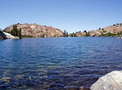
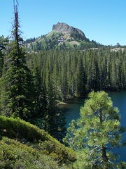
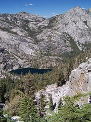
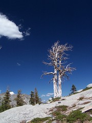
Then came the climb up to Penner Lake. Because I was sick, this took a lot out of me. But the destination was well worth it. Unlike the crowded lakes close to the trail head, there were just 3 people here--women who had been camping there.
Penner Lake
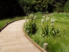
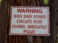
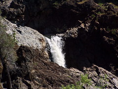
Despite being worn out, I stopped on the drive home to walk the Sierra Discovery Trail, a very easy, wheelchair accessible trail with interpretative signs that took me to a waterfall on the Bear River. I was amused by the signs warning to evacuate the area when the sirens go off. When PG&E releases a large amount of water, the river area floods, apparently.
Sierra Discovery Trail
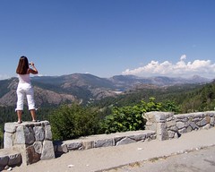
On the drive home, I really started to suffer. My illness had me stuffed up, and on the drive down my ears wouldn't pop with the elevation change, and became painful. I made one stop at the vista point near Emigrant Gap where you have a nice view of Lake Spaulding.
Vista Point
Hike Summary
Date: 9 July 2006 Trail head: Carr-Feeley Approximate distance: 6.4 miles
This hike begins at some lovely mountain lakes near Soda Springs, about 88 miles from Sacramento on Interstate 80. The book California Hiking mentioned that you have to take a dirt road to the trail head, but it didn't say anything about the condition of the dirt road. I downloaded a map for this hike from waterfallswest.com, but failed to read the description of the hike on that site. Had I done so I would have been aware that this road is best suited for high clearance four wheel drive vehicle. My wheels were spinning at one point on the way out, and one point on the way back. I made it, but I would not take my Metro on this road again.
I got to a warming hut that had a map on it and decided to verify that I was going the right way, as the directions from California Hiking had not been accurate to that point. As I was there a couple came hiking up the road and I asked them if I was headed the right way to the Palisades Creek Trail, and if there was a parking lot up ahead. They told me I was headed the right way, but the road was impassable up ahead. So I hiked down the road from there. I immediately saw what they were talking about--just one small section so rough that I would not have wanted to try it.
But there were 5 SUVs at the official trail head (signed Palisades Creek Trail), and another that joined them as I was walking by. More surprising was a Ford Focus parked there.
From the trail head I took a short, steep hike down to a dam separating the upper and lower Cascade Lakes. I walked across the dam and across a bridge over a spillway to the trail that was signed with various destinations and distances.
Devils Peak
There seems to be some confusion about this hike. California Hiking (2001-2002 edition) lists the distance as 10 miles round trip, and refers to the spur at the end as Heath Falls Overlook Trail. The map that I downloaded from waterfallswest.com indicates that it is a 13.6 mile round trip. I read the description of the hike from that website when I got home, and it said it was a 12.8 mile hike. At the trail head there is no mention of an overlook of Heath Falls, but the Heath Springs Overlook is listed at being 7 miles away, for a 14 mile round trip. In my judgment, it's at least 12.8 miles, and possibly longer.
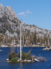
Across the lakes, the hike starts climbing. Devils Peak looms on the right, and at points there are nice views of Long Lake to the left, and the mountains behind it. This is mostly open granitic terrain, so occasionally it's hard to pick up the trail, but there were plenty of cairns, and even when I briefly got off trail I soon found myself back on it.
After climbing up, I started down and passed through a pleasing variety of environments, crossing a few creeks, going through forest, and even seeing a couple of meadows. This is very much unlike my other visits to the North Fork American River, which have all been on short steep trails.
The trail doesn't seem to get much usage, although the Sacramento Hiking Meetup group from meetup.com had an outing there the day before I went. I didn't see anybody on the way out, although I saw two tents down below on the opposite shore of Long Lake. And the trail was overgrown in places-it was still easy to see the path on the ground, but I had to push through branches of bushes a few times.
There are two markers to let you know how far you are along the trail, both bridges. The first bridge just crossed a dry creek bed that must be flowing early in the season (or at this time of year in a year with more snow). The other crosses a lovely creek that I came to the edge of a ways before the bridge. In fact, when the trail appeared to come up to the creek, I rock hopped across it. Finding no trail on the other side, I looked back and saw the trail continued along that side.
Shortly after crossing the second bridge I hit the junction with the trail to . . . whatever that trail is there for. I thought it was for an overlook of Heath Falls. The junction was just marked with three cairns. I turned left, and the trail became indistinct, but a sign nailed to a tree reassured me with the words "Heath Falls."
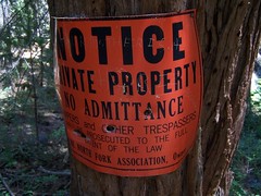
The trail was not distinct, but was easy enough to follow by just keeping a sharp eye out. Then I came up to trees all marked with signs saying this was private property and any trespasser would be prosecuted to the fullest extent of the law. I wasn't expecting that. I figured that this just meant I shouldn't leave the trail (or camp, of course). Unfortunately, it was not so easy to stay on the trail.
Uh-Oh
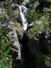
I got to a point where I could catch glimpses of the waterfall through the trees, but I was looking for this overlook point that California Hiking mentioned, even though I had already gone at least a mile, and the book said it would be 1/2 mile from the junction. Again, had I read the description waterfallwest.com before I made the hike, I would have been prepared for this. All you get for an overlook is a view through the trees. It's dramatic, but challenging to photograph.
The trail was really obscure and difficult as I continued, with trees overgrowing it, and rock slides covering it. I did a lot of scrambling. Finally I got to a point at which the trail became clear and I started doing a lot of climbing. But by now I was well past the falls. I checked my map and saw there was a trail shown on it that continued upriver. Presumably I was just about at the Heath Springs Overlook. I went back, and once again had trouble following the trail. I ended up lower down the mountain than the trail. I could see that I could probably make a scramble down to the base of the falls at this point, but I was getting exhausted from scrambling already, and I had a long hike back. Compounding all this was the fact that I had left the burrito I was going to eat for lunch in the car, so I was without food for the whole hike.
I thought it more important to get back on the trail home at that point, and I did some mad scrambling up the side of the mountain, getting dirty and scratched. I was totally out of breath when I reached the trail again. I went back and found the best view I could through the trees, and took a photograph from there--not exactly what I had hoped for.
Heath Falls
Then I started my return. A ways after recrossing the second bridge, I encountered 3 hikers taking a rest on their way down. They asked me how far away the bridge was and about the trail to the mythical Heath Falls Overlook. They weren't encouraged by my answers.
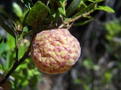
Berry?
I pushed on. I had a rock in one boot, and the other boot was cutting into my heel, and I was out of water in my primary canteen and needed to change my drinking hose to my secondary canteen. But I just kept pushing myself on until I hit that first bridge. At that point I knew I was making good time, and could afford to stop to take more photos.
I ran out of energy about a half hour after crossing that bridge, and just had to plod on from there. Back at the car, I got out of my boots as quickly as possible, as usual. I know that the guidelines for food safety would probably suggest that you avoid eating a steak and potato burrito that has been sitting in a car for 8 hours, but I devoured it at that point.
Hike Summary
Date: 24 June 2007 Trail head: Devils Lookout Warming Hut Approximate distance: 13 miles? Links: waterfallswest.com trail description, Sacramento Hikers Meetup group hike report
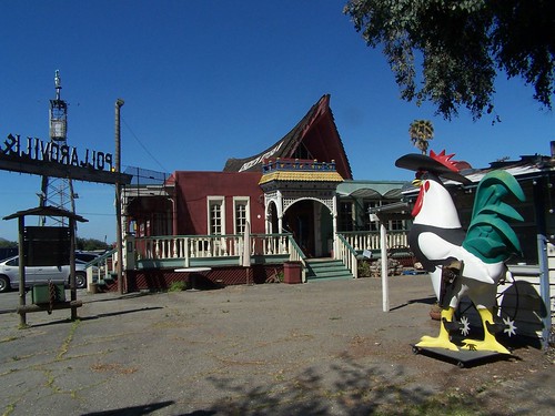
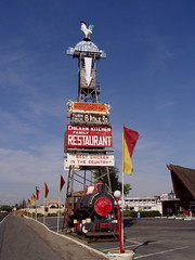
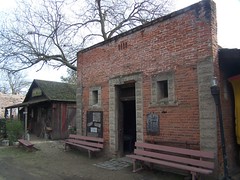
Just north of Stockton on the frontage road paralleling CA 99-what was US 99-stood the Chicken Kitchen Restaurant and the roadside delight known as Pollardville. Named after the founders of the restaurant, Ray and Ruth Pollard, Pollardville was set up as a ghost town, with two authentically historic buildings, and the movie set from The Big Country (a 1958 western starring Gregory Peck). Future dinners in the restaurant (chickens, that is) mingled with tourists roaming this quaint roadside attraction.
Future Chicken Dinner
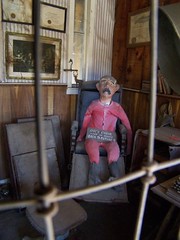
The Pollards appreciated old things, and collected anything they considered of value and stored it at Pollardville. You could find the barber's chair from Back to the Future 2, antique farm equipment, and salvage from historic buildings that had been torn down. Many of the items were available for purchase, and there was a small antique store in one of the movie set buildings.
Chair from Back to the Future 2
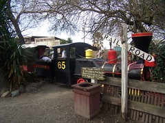
A narrow gauge railroad ran throughout Pollardville, and visitors could ride it for a small fee. On my ride, a gate had been left closed, so the train had to stop for the conductor to open it.
Video of the Train Passing
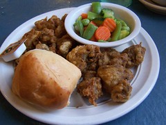
Inside, the restaurant featured more antiques and memorabilia. For a special treat, you could dine in a jail cell, or a stagecoach. The menu of the Chicken Kitchen naturally featured fried chicken. On one of my last visits, people at the table behind me, who had driven a long ways to dine there, were disappointed to hear they were out of gizzards, so next time there I made sure to order the mixed giblets (gizzards and livers).
Mixed Giblets
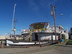
Next door was the Palace Showboat, a building that looked very much like a riverboat. It was used as a theater. To attract the attention of people on the freeway, there was a giant sign out front, with a chicken up top and a lighted arrow pointing down. A locomotive stood at the base of the sign.
Palace Showboat
Pollardville closed forever on April 1, 2007. The restaurant continued to sell food to go for a couple of months afterwards. Before closing, the owners made nearly everything for sale. I would have liked a souvenir, but the prices were way too high for me. I did get myself a t-shirt and a postcard, in addition to my pictures and video footage.
I was worried about the fate of the Jamestown Jail, a brick building built in 1897 that was moved from Sonora County to Pollardville. A historical society from the county was trying to raise $35,000 to save it and move it back. Fortunately, their website indicates that they were successful.
From what I have read, the developers' plans for the area are to construct a shopping center and gated community.
Jamestown Jail
Below is the story of the restaurant as told in a handout that was available on the player piano near the restaurant's entrance. I've copied it as is, mistakes included.
-------------------------------
The Pollardville Story
The original Chicken Kitchen was first established at the Red Gate Farm Chicken Ranch in Castro Valley in 1944 by Ray and Ruth Pollard. It evolved from a roadside business selling eggs and poultry to selling chicken sandwiches and then to the original "Chicken on a Bun" was born and served thru a window to become the first or one of the very first food to go restaurants. In 1946 the business was moved to Stockton on the West side of the highway by Mosher Slough opposite Ashley Lane. It opened to accommodate 18 patrons served at a counter, three tables and a take out window and over the next 10 years grew to a capacity of 125. In 1957 having outgrown the premises the restaurant was moved to the present 16 acre location and Pollardville was in its beginning of phases of permanent growth. As its business grew so did the ghost town which included the smallest post office in the U.S. purchased from Mountain Ranch, CA., another authentic building was the Jamestown Jail on Main Street. To help complete the town the entire movie set from the 1957 film "The Big Country" was added, along with on half mile C.K.R.R. Narrow Guage Railroad, a stage coach line and occasional shoot out on Main Street.
The town was on its way. 1965 saw the first melodrama Vaudeville show open at the Palace Showboat Dinner Theatre. Then the fire of Dec. 1984 leveled the entire main restaurant. Not undaunted Neil and Tracy Pollard in March 1987 reopened by moving yet another structure with charm and character the Islander Restaurant that stood on the corner Benjamin Holt and Pacific Ave. in Stockton and remodeled to fit the Pollardville theme. The project now at hand includes development of a wedding reception, concert and company barbeque picnic area. This is just another chapter in the on going building at Pollardville.
While beginning and ending in Muir Woods National Monument, this hike went well outside of it as well.
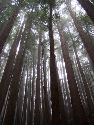
My friend Erik and I were on the same project together at work, and could have worked this particular Saturday. I did work the next few weekends, but that day I just really needed to get away. So I made my first ever visit to the redwood forest of the Golden Gate National Recreation Area, and took Erik with me.
We started at the main parking lot, which still had open spots. Later in the day even the auxiliary parking lot gets full, and people circle around waiting for someone to leave. We put on all our hiking gear, which made us look quite out of place among all the tourists who just stroll around the boardwalk and paved trail and return to their cars. I always enjoy having foreign tourists around me speaking other languages, as it makes me feel as though I am on vacation.
How did I get a shot without people in it?
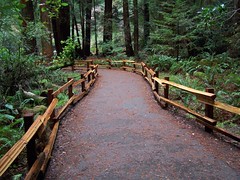
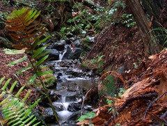
A lovely stream runs through the center of this area, with the boardwalk and paved trail running up and down each side, and a bridge across. Once we got to the hiking trail, Bootjack Trail, and started climbing, the crowds disappeared.
It was a foggy day with the occasional drizzle, but that only added to the atmosphere of this hike. It was dark, foggy, green, wet, and enchanting. The slithy toves did gyre and gimble in the wabe. Of all my photos, I think the one below best captures the mood of the place that day.
Bootjack Trail is a long climb up, but every step of the trail was a delight. At one point I turned to Erik and said, "You know, we could be at work right now." We both had a good laugh.
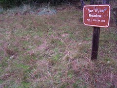
We stopped by Van Wyck meadow, and I had to get a picture of the sign--less for intentional humor of "POP. 3 STELLAR JAYS" than for the unintentional humor of choosing the adjective "stellar" rather than the name Steller, the German naturalist for whom the birds are named.
Rather than return on the same trail, I planned on a loop. From Bootjack Trail we took T.C.C. Trail to Stapelveldt to Ben Johnson Trail, and took that the rest of the way back. We kept going down and down, much farther than I was expecting. I hadn't realized we had done that much climbing. These other trails were not nearly as enchanting as Bootjack Trail, but I prefer to see as much as possible.
Finally, we got back to crowded area and worked our way back to the parking lot on the opposite side of the stream from what we had been on before. Not long afterwards, a major storm moved in, and Erik and I raced it back to Sacramento.
Hike Summary
Date: 9 December 2006 Trail head: Muir Woods Approximate distance: 6 miles Links: Official website
To the west high above incredible Emerald Bay of Lake Tahoe is a granite basin filled with pristine mountain lakes in the Desolation Wilderness, three of which are the Velma Lakes, Upper, Middle, and Lower. Two trailheads offer the most ready access to this area: Eagle Falls and Bayview Campground. I undertook the hike via Eagle Falls and Eagle Lake on the Emerald Bay Trail last week. But my first ascent into this area, last year, and my most recent, yesterday, were both on the Bayview Trail from Bayview Campground.
Both trails are steep and rated as strenuous in the book Tahoe Sierra, but I chose the approach via Bayview Trail for my first visit because it is described as being "better graded," and I thought it would be easier. It starts 260 feet higher than the trail to Eagle Falls and Eagle Lake, but, then again, it climbs about 220 higher than that trail before descending to a junction with it. I'd say they are equally as difficult, although the rockiness of Emerald Bay Trail makes it harder on the joints.
Make Your Choice
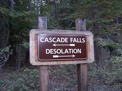
This hike starts at a sign-in board (permits are required for entering the Desolation Wilderness) right at the day use parking area in Bayview Campground, just off of CA 89, the highway that runs along the western shore of Lake Tahoe. This is also the trailhead for a short (.7 mile) and easy hike to Cascade Falls overlooking Cascade Lake, so there can be quite a few cars in the lot, as there was in my second hike on this trail, with my friend Erik.
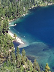
The hike begins at 6860 feet with a steep series of switchbacks in wooded terrain. Soon after passing the sign designating the boundary of the Desolation Wilderness, views start opening up of Emerald Bay. There are vistas of more of Lake Tahoe through the trees, but better views lie farther up the trail.
Emerald Bay
At the end of this series of switchbacks, the trail heads away from the views and farther west into the forest. A use trail appears off to the left. This heads to Granite Lake. Staying on the main trail, Granite Lake doesn't come into view until you are already a little above it.
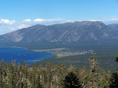
Then starts another grueling climb up a series of switchbacks. There are glimpses of Lake Tahoe, Granite Lake, Cascade Lake, and South Lake Tahoe throughout this climb, but every once in a while there is a gap in the trees that provides a much clearer view.
View of South Lake Tahoe
At the end of this series of switchbacks, the trail once again swings west and away from the views of Lake Tahoe, but there is an area where many people have gone off the trail to the north to catch a glimpse of Eagle Lake surrounded by granite slopes.
Eagle Lake
This part is the easiest of the whole hike, with just modest ups and downs, topping out at around 8440 feet, for 1580 feet of elevation gain in about 2 1/2 miles. Then begins a descent of about 220 feet to the junction with Emerald Bay Trail, signed Eagle Lake.
After this junction begins a down an up portion of .9 miles to the junction with the trail to Dicks Lake. That junction is at the same elevation as the previous one, but there is some climbing and descending to do between them. Off to the south are expansive views of granite mountains.
Then the trail begins a steady descent to a creek at about 7950 feet that must be crossed via rock hopping. I found it a bit of a challenge in 2006. But yesterday, I found it quite simple. Having crossed that creek from the other direction last week, where the easiest crossing is more plainly visible, I knew to leave the trail and go a couple of yards up creek for an easy crossing. I crossed, then set up to film my friend Erik cross. He saw me over to the left, but didn't look for a crossing near me. He just went straight across where the trail ran into the creek--a much more difficult route. I don't know that I would have been able to make it across that way, and Erik nearly didn't, having to flail his arms near the end to keep his balance. And yes, the whole time I just stood there quietly filming him.
In 2006 I just went straight on past the junctions for trails to Upper Velma and Fontanillis Lakes to the west shore of Middle Velma Lake, just off the Pacific Crest Trail. But yesterday I wanted to make it to Lower Velma Lake as well, to which there is no official trail. From the topographic map it was clear that this would mean quite a bit of descent and then a climb back up on the return, so I offered Erik the choice of coming with me, or just going on to Middle Velma Lake where I would meet him. He chose the latter. I showed him the map and told him to pass the two trail junctions before arriving at Middle Velma Lake, and that I would meet him there.
I started heading down parallel to the creek, which the maps shows flowing into Lower Velma Lake. As soon as I could see the lake, I veered off toward it, and ended up on the edge of a cliff about 40 feet above it. I didn't see suitable areas on shore to hang out and I wasn't planning to hang out there anyhow, so I just took pictures from up on the cliff before starting back up.
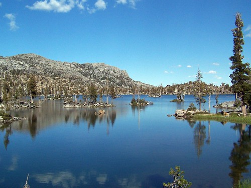
Lower Velma Lake
I ended up back on the trail just a bit farther along than the creek crossing. I headed on towards Middle Velma Lake. It was only then that I was reminded that the trail doesn't really go to Middle Velma Lake, it just skirts around it to the south and west. At some point I just had to go off trail--there are many faint use trails, some marked with cairns--to get to the lake. I chose one and ended up about where I had been last year.
The book mentions that the lakeshore can get crowded, but last year there were just 2 other people there, although I did find evidence of people having camped there, like an old tube of toothpaste. This year I just saw a family of 4 camping nearby who said hello to me.
At the water's edge, I searched the shores for Erik. He could have chosen anywhere to get over to the lake, or kept going thinking that the trail would eventually arrive at the lake. I didn't call out for him as I didn't want to disturb the family.
Middle Velma Lake
He had talked of lingering by the creek a while, so I started heading back thinking I might find him there, and that I could just wait for him there in case I didn't find him, as he would have to return that way eventually to get back to the car. But I soon encountered him. He had forgotten which Velma Lake he was supposed to go to, and headed to Upper Velma Lake. Not having passed a junction for Fontanillis Lake, he knew he had erred, and returned. It's a lucky thing I didn't get back past the junction with the trail to Upper Velma Lake before he had gotten back to the main trail, or we would have missed each other.
At the point I met him we just wandered across the granite rocks to the lake's edge. After taking some pictures, we went swimming out to a couple of the myriad granite rock islands in the lake. It wasn't the best place for it--the rock islands were tiny, unlike the larger ones with nice granite slabs to lie on a little farther north. But we didn't have much time to spare and couldn't be picky.
I swam out to two, and got an inconsequential cut on my foot on some of the jagged rocks underwater near the second island, and then swam back. Erik went on to a larger third island while I dried out on the granite in the sun.
Then we made our return. We made good time, despite having to do some climbing on the way back before the long final descent. That descent we took quite rapidly--much faster than would be possible on rocky Emerald Bay Trail. We got back to the car 7 hours after having headed out.
Emerald Bay on the Return Trip
Hike Summary
Dates: 7 September 2006 & 25 July 2007 Trailhead: Bayview Campground Approximate distances: 11 miles & 12 miles
Rancho Seco is the site of a decommissioned nuclear power plant owned by SMUD, just 25 miles southeast of Sacramento. In addition to permanently monitoring the remaining power plant structures there, SMUD provides recreational opportunities. There's a lake with boating, fishing, and a cordoned off swimming area. There are picnic and camping areas, and place to park RVs. And then there is the 7-mile Howard Ranch Trail.
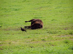
The trail begins on the northeast corner of the lake at a parking lot used by many fisherman. I walked around a bit of the lake, and then was out into open terrain that had a few cows grazing in it.
The terrain appears barren, at first glance, but while it will never compete with the drama of the high Sierra or of Point Reyes, it is more interesting than it first appears. It resembles nearby Mather Regional Park. Both are situated in between the lowest part of the valley and the foothills, where the land is just starting to rise and form hills. There are vernal pools that support much life, and it is the habitat of the burrowing owl. In summer I would only consider hiking here just after sunrise and just before sunset--which is probably the best time to see it any time of the year, when the animal life is more active. But it was February, and I went in the middle of the day.
That's the positive side of it, and I'm sure someone well attuned to the subtleties of nature would find it a fascinating place to visit. I, on the other hand, was bored, and kept asking myself, "Why would anyone bother to make a hiking trail here?"
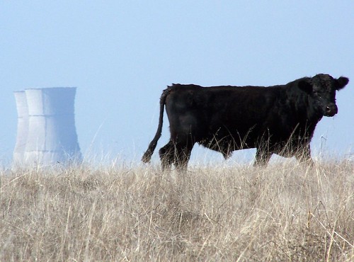
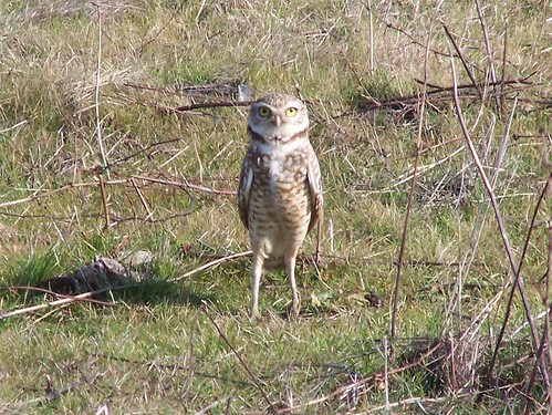
There were two highlight for me: getting a shot of a cow juxtaposed against the cooling towers of the nuclear power plant, and the burrowing owl I spotted.
I didn't even know such a thing existed. As the trail went by where this owl stood sentinel (I read up on the subject when I got home--one owl stands guard while the rest sleep below ground), it started hopping around and bobbing its head up and down, presumably trying to intimidate me.
"Back off!"
This hike was short and easy, and there wasn't much to stop and photograph, so I did it quickly. When I got back to the car, I explored the other recreational opportunities of the site. Then, rather than return home, I couldn't resist running by A&W in Lodi, the birth place of A&W, to visit the drive-in.
The trail didn't take much out of me, so I was able to go on a much longer hike at Point Reyes the next day.
Hike Summary
Date: 3 February 2007 Approximate distance: 7 miles Links: Official site
This was just my second hike in my newfound career as a hiker, and it proved how little I knew about hiking.
The Stevens Trail (apparently the Bureau of Land Management shares the disdain for the apostrophe that the National Forest Service and National Park Service feel) is just off of the Interstate 80 exit for Colfax, about 49 miles from Sacramento. It took me a little while to find the trail head using the directions from California Hiking.
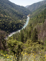
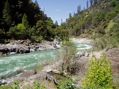
There are many hikes down to the North Fork American River from both the northern side and the southern side. They all share the traits of involving a big descent on the way out, which means a tough climb on the way back, and of being unsuitable for typical summer temperatures, as you are not at a high enough elevation to avoid the valley heat. This particular hike is one of the easier ones, but it wasn't easy to me at the time.
There were plenty of people on the trail that day, and observing them was interesting to me. I saw some people who had dropped a lot of money at REI, and were wearing everything you could possibly hope to for hiking and using expensive poles. Another woman jogged the whole trail and did not have water with her, which is still amazing to me.
The trail splits at one point. Bicyclists are supposed to go one way, and hikers another. I took the hikers' way. That led me to crossing a seasonal creek above a waterfall, and I was uncomfortable with the crossing. A slip would have pretty much been the end of me. There was no mention of danger in the description of the hike I had read.
Much of the trail had me a little uneasy because it was such a steep drop off to the side of it. I can't imagine traveling it on a bicycle.
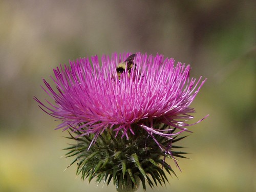
About midway down, I found some bull thistles, with a bee visiting them (pictured up top).
I got down to the river and ate my lunch next to the river on the sand. Then the fun started.
For water I had two canteens I had bought from an Army Navy Surplus store. I had frozen one overnight, so it would be cold throughout the hike. But it hadn't thawed much by the time I started my return trip. I was already out of water as I headed back up the trail, with just a chunk of ice rattling around inside my canteen.
I had no experience in pacing myself. At the gym, I went on the treadmill at a fast pace, and adjusted the incline to whatever I could handle at that pace. But there's no adjusting the grade on a hike. I went fast until I ran out of breath and had to stop and rest. And I kept doing that. I would put my canteen on my neck to cool me off and melt some of that ice, and then drink whatever few drops I could get out of it.
When I came to the split in the trail, I took the route for bikers. That led me to an easier creek crossing, and also took me pass an old truck rusting by the side of the trail. I have no idea how it got there.
I was stopping to catch my breath more and more frequently as I got towards the end of the hike. When I got back to my car, I reached into my pocket for my car keys. I didn't find them. I panicked. I thought they might have fallen out while I was sitting next to the river. But I found them in another pocket--I have no idea why I put them there.
Once I was able to open the car, I grabbed a bottle of water that I kept on hand in case of emergency, and drank the whole thing, even though it was hot. I made good time. My book said the hike would take 5 hours, and it only took me 3 hours and 20 minutes. But I was totally spent.
I've since done much more difficult hikes down to the North Fork American River and found them easier, like the Mumford Bar Trail, which has 2700 feet of elevation change, compared to just 1200 for Steven Trail. Pacing myself makes all the difference.
Hike Summary
Date: 7 May 2006 Trail head: Stevens Trail Approximate distance: 9 miles Links: official information
April 29, 2006 was the day I became a hiker. I had done a few hikes spread over many years before, and even owned an expensive pair of hiking boots. But as of that day I started hiking regularly and have built up enough strength and endurance to hike to amazing places most people in the area will never see.
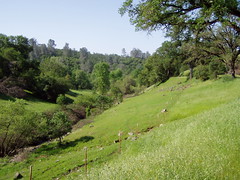
I initially had two motives for taking up hiking. I wanted to take more photos, and I wanted to get into better shape. But I needed to start out with an easy hike, and one that was suitable for April, which led me to choose the Shingle Falls hike out of California Hiking.
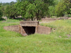
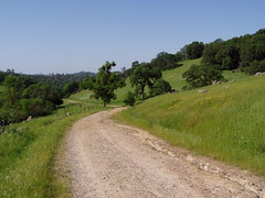
It was an adventure to me just to get to the place on obscure roads and dirt roads. At the trail head there was an old concrete bridge that didn't connect anything, a remnant of some past farming or ranching operation. The first part of the hike is just an old road no longer used by vehicles that crosses another concrete bridge.
The Trail
I hiked up the road to the turnoff for the trail to the falls. I encountered a surprising number of people on the way, some of whom asked if I was headed towards Fairy Falls. My book said they were officially named Shingle Falls but were commonly known as Dry Creek Falls (because it's dry later in the year).
Near the turnoff, a father and his two sons with BB guns told me about a dead cow up ahead and a bobcat they had seen near it.
I saw the dead cow, and the vultures circling over it, but never saw a bobcat. Later I was surprised to see a tree that had blown completely over and had its roots in the air. I see a dozen such trees on any given hike in the high Sierra now, but at the time it was something new, and I took a picture.
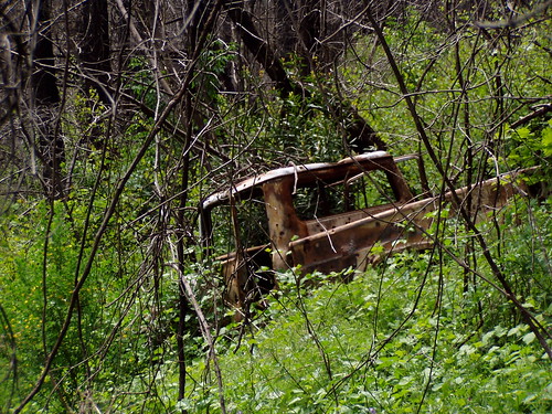
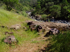
There was a small waterfall before the main one. And somewhere along the creekside I found rusted old equipment.
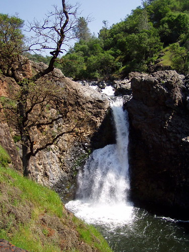
Finally, I reached the large waterfall, old What's-Its-Name Falls. There was a cliff here by the lower portion of the creek, and it was fenced off. I wandered up and down it a bit.
I had seen a narrow foot path head off the main trail, which I took on the way back, figuring it was a short cut. I'm not sure if it is shorter, but it didn't go up and down so much, and got me back.
On the Shortcut
I had been spending enough time in the gym on the elliptical trainer and treadmill that the distance and the climbing were no problem for me. But I hadn't been doing anything at the gym that resembled hiking downhill. The fronts of my legs below the knee is where I was sore the next day. Apparently those are the muscles that keep you from plunging downhill at full speed.
I had plenty of time afterwards, so I resumed my more usual hobbies, eating at Shakey's Pizza in Oroville, and photographing buildings and neon signs.
Hike Summary
Date: 29 April 2006 Approximate distance: 5 miles Links: Map