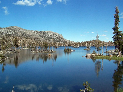
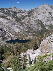
Middle Velma Lake
To the west high above incredible Emerald Bay of Lake Tahoe is a granite basin filled with pristine mountain lakes in the Desolation Wilderness, three of which are the Velma Lakes, Upper, Middle, and Lower. Two trailheads offer the most ready access to this area: Eagle Falls and Bayview Campground. I undertook the hike via Eagle Falls and Eagle Lake on the Emerald Bay Trail last week. But my first ascent into this area, last year, and my most recent, yesterday, were both on the Bayview Trail from Bayview Campground.
Both trails are steep and rated as strenuous in the book Tahoe Sierra, but I chose the approach via Bayview Trail for my first visit because it is described as being "better graded," and I thought it would be easier. It starts 260 feet higher than the trail to Eagle Falls and Eagle Lake, but, then again, it climbs about 220 higher than that trail before descending to a junction with it. I'd say they are equally as difficult, although the rockiness of Emerald Bay Trail makes it harder on the joints.
Make Your Choice
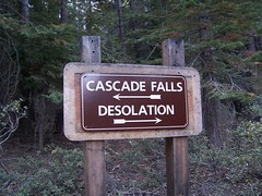
This hike starts at a sign-in board (permits are required for entering the Desolation Wilderness) right at the day use parking area in Bayview Campground, just off of CA 89, the highway that runs along the western shore of Lake Tahoe. This is also the trailhead for a short (.7 mile) and easy hike to Cascade Falls overlooking Cascade Lake, so there can be quite a few cars in the lot, as there was in my second hike on this trail, with my friend Erik.
The hike begins at 6860 feet with a steep series of switchbacks in wooded terrain. Soon after passing the sign designating the boundary of the Desolation Wilderness, views start opening up of Emerald Bay. There are vistas of more of Lake Tahoe through the trees, but better views lie farther up the trail.
Emerald Bay
At the end of this series of switchbacks, the trail heads away from the views and farther west into the forest. A use trail appears off to the left. This heads to Granite Lake. Staying on the main trail, Granite Lake doesn't come into view until you are already a little above it.
Then starts another grueling climb up a series of switchbacks. There are glimpses of Lake Tahoe, Granite Lake, Cascade Lake, and South Lake Tahoe throughout this climb, but every once in a while there is a gap in the trees that provides a much clearer view.
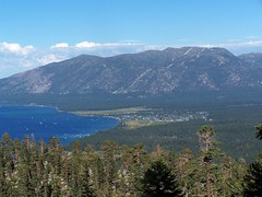
View of South Lake Tahoe
At the end of this series of switchbacks, the trail once again swings west and away from the views of Lake Tahoe, but there is an area where many people have gone off the trail to the north to catch a glimpse of Eagle Lake surrounded by granite slopes.
Eagle Lake
This part is the easiest of the whole hike, with just modest ups and downs, topping out at around 8440 feet, for 1580 feet of elevation gain in about 2 1/2 miles. Then begins a descent of about 220 feet to the junction with Emerald Bay Trail, signed Eagle Lake.
After this junction begins a down an up portion of .9 miles to the junction with the trail to Dicks Lake. That junction is at the same elevation as the previous one, but there is some climbing and descending to do between them. Off to the south are expansive views of granite mountains.
Then the trail begins a steady descent to a creek at about 7950 feet that must be crossed via rock hopping. I found it a bit of a challenge in 2006. But yesterday, I found it quite simple. Having crossed that creek from the other direction last week, where the easiest crossing is more plainly visible, I knew to leave the trail and go a couple of yards up creek for an easy crossing. I crossed, then set up to film my friend Erik cross. He saw me over to the left, but didn't look for a crossing near me. He just went straight across where the trail ran into the creek--a much more difficult route. I don't know that I would have been able to make it across that way, and Erik nearly didn't, having to flail his arms near the end to keep his balance. And yes, the whole time I just stood there quietly filming him.
Erik Rock Hops the Hard Way from tspauld and Vimeo.
In 2006 I just went straight on past the junctions for trails to Upper Velma and Fontanillis Lakes to the west shore of Middle Velma Lake, just off the Pacific Crest Trail. But yesterday I wanted to make it to Lower Velma Lake as well, to which there is no official trail. From the topographic map it was clear that this would mean quite a bit of descent and then a climb back up on the return, so I offered Erik the choice of coming with me, or just going on to Middle Velma Lake where I would meet him. He chose the latter. I showed him the map and told him to pass the two trail junctions before arriving at Middle Velma Lake, and that I would meet him there.
I started heading down parallel to the creek, which the maps shows flowing into Lower Velma Lake. As soon as I could see the lake, I veered off toward it, and ended up on the edge of a cliff about 40 feet above it. I didn't see suitable areas on shore to hang out and I wasn't planning to hang out there anyhow, so I just took pictures from up on the cliff before starting back up.
Lower Velma Lake
I ended up back on the trail just a bit farther along than the creek crossing. I headed on towards Middle Velma Lake. It was only then that I was reminded that the trail doesn't really go to Middle Velma Lake, it just skirts around it to the south and west. At some point I just had to go off trail--there are many faint use trails, some marked with cairns--to get to the lake. I chose one and ended up about where I had been last year.
The book mentions that the lakeshore can get crowded, but last year there were just 2 other people there, although I did find evidence of people having camped there, like an old tube of toothpaste. This year I just saw a family of 4 camping nearby who said hello to me.
At the water's edge, I searched the shores for Erik. He could have chosen anywhere to get over to the lake, or kept going thinking that the trail would eventually arrive at the lake. I didn't call out for him as I didn't want to disturb the family.
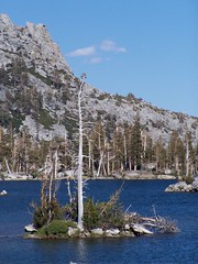
Middle Velma Lake
He had talked of lingering by the creek a while, so I started heading back thinking I might find him there, and that I could just wait for him there in case I didn't find him, as he would have to return that way eventually to get back to the car. But I soon encountered him. He had forgotten which Velma Lake he was supposed to go to, and headed to Upper Velma Lake. Not having passed a junction for Fontanillis Lake, he knew he had erred, and returned. It's a lucky thing I didn't get back past the junction with the trail to Upper Velma Lake before he had gotten back to the main trail, or we would have missed each other.
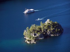
At the point I met him we just wandered across the granite rocks to the lake's edge. After taking some pictures, we went swimming out to a couple of the myriad granite rock islands in the lake. It wasn't the best place for it--the rock islands were tiny, unlike the larger ones with nice granite slabs to lie on a little farther north. But we didn't have much time to spare and couldn't be picky.
I swam out to two, and got an inconsequential cut on my foot on some of the jagged rocks underwater near the second island, and then swam back. Erik went on to a larger third island while I dried out on the granite in the sun.
Then we made our return. We made good time, despite having to do some climbing on the way back before the long final descent. That descent we took quite rapidly--much faster than would be possible on rocky Emerald Bay Trail. We got back to the car 7 hours after having headed out.
Emerald Bay on the Return Trip
Hike Summary
Dates: 7 September 2006 & 25 July 2007
Trailhead: Bayview Campground
Approximate distances: 11 miles & 12 miles
3 comments:
My Tahoe vacation is coming up in a few weeks. Your photography is really making me wish that day would hurry up.
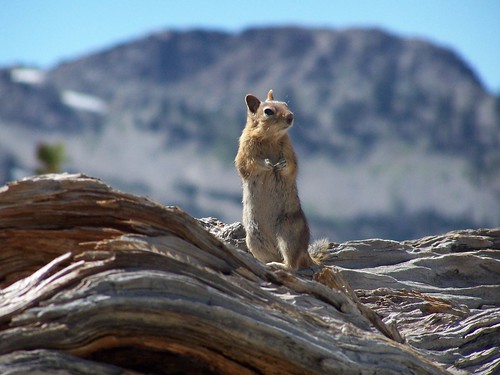
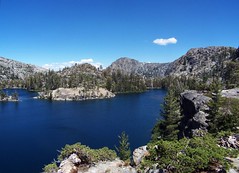
Three things stand out to me. The video of Erik. The critter picture. But mostly, the photo of the lake at the top of the page. When you look directly at the trees, you can't see them well because of the hills in the background. But they show up great in the reflection in the lake. Cool.
Thankss for the post
Post a Comment