Some of my photos are now for sale at ImageKind.

Nature Index
(My hiking and camping adventures in Northern California.)

Culture Index
(NorCal cities, highways, restaurants, museums, architecture, historic attractions, vintage neon signs, roadside attractions, etc.)

Thursday, November 18, 2010

Napa's Old Man Rock on Monticello Road

20101119 Old Man Rock, 3

Recently at the Friends of the Sacramento Library's Book Den I picked up several local history history books on the cheap, and in one, There's a Little Spot I Know (by Jim Babcock, published by the Sacramento Bee in 1985), there is a photo of a “well-known Napa County landmark” described as being “10 miles east of Napa” on Monticello Road. It's a rock formation overhanging that highway that resembles an old man. To add to the resemblance, a piece of metal in the shape of a pipe has been added.

Having moved to Napa five months earlier, I wondered about not having seen or heard anything of the supposedly well-known landmark. I did several searches on Flickr, but didn't find any photos of it. Google searches turned up several references, but mostly historical. It has been referred to variously as Old Man with a Pipe, Old Man Rock, and the Old Irishman. One piece from the Napa Valley Register on a postcard collector in September of 2008 mentioned that he had a card with a photo of the rock formation “back when the stone nose was longer,” the only indication I had that the rock formation could still be seen along Monticello Road.

As soon as I had a decent opportunity, I set off in search of Old Man Rock, as I have chosen to call it. Monticello Road apparently originally led from Napa to the town of Monticello. The original town site now lies beneath the waters of Lake Berryessa, formed by the construction of the Monticello Dam beginning in 1953. Apparently photographers Dorothy Lange and Pirkle Jones documented the abandonment of the town in the book Death of a Valley (thanks Wikipedia, looking forward to checking it out).

Ten miles outside of Napa was a vague reference to go on, considering that I don't know what the border of the city was at the time that reference was made, but luckily the rock formation proved easy to spot. Monticello Road begins at the junction of Trancas Street, a main east-west thoroughfare on the north end of town, and the Silverado Trail, one of the two highways that runs north-south through Napa Valley. Heading out (northwest) on Monticello Rd., CA-121, Old Man Rock is to be found just 2.5 miles past the stoplight at the junction with Atlas Peak Road (the turn off for the Silverado Country Club).

There is a turnout immediately before Old Man Rock, but it is to allow faster vehicles to pass only, and there are “no parking” signs. There are several private drives nearby. I managed to park my subcompact off the edge of the road just past one of those. There's not much room for walking along the side of the road, or setting up a tripod either. My tripod seemed in constant danger of being swiped by cars coming down around the curve behind the Old Man, but I felt like I would safely be able to scramble out of the way. The best place to photograph the rock from would be the middle of the road, but that would be absurdly dangerous.

According to the Napa County book in the Postcard History Series from Arcadia Publishing, the pipe was added in 1911. No word on who added it.

20101118 Old Man Rock, 1

20101118 Old Man Rock, 2

20101119 Old Man Rock, 4

Monday, September 20, 2010

Vintage Service Stations: Napa

I just moved to Napa in June of 2010, and found myself faced with an overwhelming number of subjects to photograph and research. I set about them without any particular plan until my research on one particular subject (I don't recall what now) led me to the website for the splendid organization Napa County Landmarks. Every year they compile a list of ten threatened historical sites in the county. This 2010 list included two old service stations that had caught my eye. Follow-up information on their website on one of them indicated that it could be demolished any day, so that made me prioritize my efforts. Thus my first blog entry on my new home is on the historic service stations in the city of Napa—both the two threatened ones, and two other lovely old stations that thankfully do not appear to be in danger of disappearing on us anytime soon.

20100819 Union Oil Station, ca. 1947
Union Oil Station, ca. 1947
1501 3rd St.
This is the most threatened station of the lot. A Streamline Moderne gem from ca. 1947 that has seen surprisingly little alteration over the years, it fits in quite well with the newly restored Uptown Theatre (1937) just down the street. Napa is surprisingly lacking in historic examples of the sleek and sophisticated designs of the 1920s-1940s, my favorite era of architecture, which makes this little area of town particularly dear to me.
The building has been under the same ownership since 1986, and has been vacant for the the last 14 years. The owner's plan seems to be to neglect it until it either falls apart of its own accord, or it becomes so decrepit that it would be highly impractical to save it, and thus there would be little resistance to the owner tearing it down and putting up something guaranteed to make money in its place.
And indeed the owner has plans to tear it down and build a relatively safe investment in a modest structure of more contemporary design. I've viewed the plans for the proposed building: it would be a cutting-edge structure for 1985. Today the best that could be said for it is that it is familiar and non-threatening, and that it integrates housing with commercial use in the urban core (a very worthy goal).
Nobody has apparently properly researched the old Union Oil Station structure, including, surprisingly, the consultant the owner hired to offer testimony against the building's historic worthiness. That consultant, Mark Hulbert, dates the building to 1948, but offers no evidence upon which he bases this dating. I'm guessing he just checked the Polk City directories available at the library and went no further. 1948 would be a reasonable guess based on such a cursory examination. But the January 1948 Yellow Pages lists the station, so it almost certainly had to have been built by 1947. Not a significant difference to be sure, but just an indication of the carelessness with which the subject is being treated.
On the side of the owner and his consultant, it must be admitted that the building was never a substantial monument. It was not designed for the site by a prominent architect. It is not a unique and grandiose embodiment of the elite art and design of the era in which it was built. The modest size of the structure greatly limits the potential uses the owner can make of the building in any attempt to derive profit from the property.
And that is, after all, what it all boils down to: income from the investment. Because despite the fact that the building is not on a state, national, or international scale an architectural monument on a grand scale, it is quite obviously, in the view of any reasonable Napan, a historically significant architectural example for Napa worthy or preserving for future generations. All one needs to do to realize this is take a look at the building and then walk, or drive, around Napa and look for other equally interesting examples of Streamline Moderne architecture. There are a handful—the Uptown Theatre (of course), another old service station nearby (discussed below), an apartment building around the corner (720 Franklin St.), and the Family Drug building on Old Sonoma Rd. But there are just a handful—nothing at all like the wealth of Victorian architecture that Napa can boast of. The loss of a single building would mark a substantial loss of that era of the city's architectural history.
20100718 Union Oil Station, ca. 1947
Ironically, the consultant takes the best argument in favor of the preservation of the Moderne service station and turns it on its head. “Obviously, service stations do not make good landmarks. They are a transient use and type.” Sloppy thinking to go along with the sloppy research. Yes, they are of a transient use and type, which is exactly why a well-preserved specimen like the old Union Oil Station is such a rarity and a treasure! And while it is indeed obvious that in the past they have not been treated like landmarks, by no means does it follow that they do not make good ones.
Mr. Hulbert's assessment flies in the face of the trends of the last thirty years in art and architectural history to recognize that everyday art, such as the vernacular architecture of gas stations, coffee shops, and shopping centers, is as much, or more, reflective of the aesthetic of the historical era and influential on the people of that era as the more traditionally recognized monumental works of well-known artists coming out of elite academic programs. The fact that such works were common means that for many years people never considered the issue of their preservation, but that time has long passed, and it's time for Mr. Hulbert to catch up with the rest of the preservation community nationwide or step aside.
The issue at hand is not whether the building is of historic interest architecturally. That is beyond doubt. The question, as it often is in the issue of preservation, is whether it is of great enough interest to radically restrict the manner in which the property owner may try and derive income from his investment in the property. I think all of us struggling to get by can sympathize with the owner's desires, and his frustration that anyone would interfere with his right to do what he wants with something he paid to acquire.
But demolition of the structure is an irretrievably permanent act. Every city in America can point to regrets in preservation battles that were lost—treasures that exist only in photographs and words these days, and lead younger generations to question, “What were they thinking when they tore that down?” Nobody ever has the opposite reaction: “Why did this get preserved? Guess they were wrong on that one.” The people at Napa County Landmarks are working to save the station not because they hate capitalists and hate change and want to make life difficult for small business owners. They are working for the greater good of the community.
Today they are trying to find somebody willing to move the station, as the Napa city council ruled in favor of the owner, and it faces imminent destruction.


20100723 Grippi's Service Station, ca. 1920
Grippi's Service Station, ca. 1920
1802 Silverado Trail
This is the other station that made the Napa County Landmarks list, a landmark indeed given its prominent location along the Silverado Trail. It says on the building itself that it has been there since 1920, and I have no basis upon which to dispute the word of the edifice. In contrast to the other service stations in this survey, it is not of a fashionable design of the era in which it was built, but the humble structure is instead reflective of its location away from the city center—likely a rural neighborhood at the time it was built.

20100731 Mobil Service Station, ca. 1939-1942
Mobil Service, ca. 1939-1942
1538 3rd St.
Now operating as Rico's Auto Detailing. I'm not positive that this art deco building was originally opened as Mobil station, but that is what it was in the first Polk city directory that lists the business name (rather than just the business type and owner), 1950.

20100725 Napa Smog
Richfield Service Station, ca. 1935-1937
1509 Main St.
This is my personal favorite of the four service station buildings, in part because the structure that held the original signage is still extant. Now operating as Napa Smog Test Only, this is where I went for my last smog check in an effort to do my part to support the preservation of the building.

Tuesday, January 12, 2010

Point Reyes: Limantour Spit & Bucklin Trail

20100107 Mushroom
Low expectations were the order of the day as Erik and I headed out for another hike at Point Reyes National Seashore. The conditions weren't quite right for most of the more dramatic hikes there—not a lot of recent rain for Alamere Falls to be at full flow, and the low tide was not going to be particularly low, so no point in visiting the tide pool areas. So I just looked at the map and decided on a main hike that would cover some trail I haven't been on before—part of my quest to hike every last mile of official trail (whether still maintained or not) in the national park.

But before we set off on the main hike, I planned for us to do a short hike down Limantour Spit. Limantour Spit is a wide sand bar that stretches about 2 ½ miles from the shore out towards the actual point and Chimney Rock. On one side is the wide-open ocean, and on the other side is a small inlet of ocean water that divides the spit from the cliffs of the mainland, including Drakes Head. In between the cliffs are further inlets—the first (from east to west) very minor, the second forming Estero de Limantour, and the third forming Drakes Estero, large enough to have four named bays branching off of it.

There's a one-mile trail going down the center of Limantour Spit on the map, so I figured we would hike 2 miles out and back before heading off for our main hike. Only I hadn't looked at the map that closely when planning. The trail goes less than 1/2 the length of the spit, and goes along the top of a sand dune. We walked right past the start of the trail, headed down the beach, and kept going past the end of the trail and the end of the sand dune.

20100107 Prints

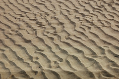
The initial portion of the hike was beautiful, of course, with a wide expanse of beach stretching on seemingly forever, and the waves gently crashing. But it got more interesting once we passed the end of the sand dune on our right. Then came a series of smaller sand dunes separated by open gullies through which we could see the muddy low areas on the north side of the spit exposed by the receding tide and backed by the cliffs on the other side of the inlet that separates the spit from the mainland. We walked along the edge of this wet tidal area, enjoying the views of the cliffs and the esteros.

20100107 Line & Shadow 2

We hiked out more than 2 miles, and since I had only planned on hiking out 1 mile, it took us longer than I had planned. I would have liked to have gone all the way to the very end of the spit, and we weren't that far from it. I know people go out there, because I've seen them from Sunset Beach, on the mainland. But we were at the point of low tide, and not having been out there before, I wanted us to get back without giving the tide a chance to rise any higher than it had been when we set out.

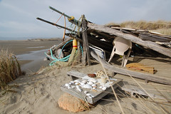
Before returning, I climbed up the last sand dune to check out the view, and immediately noticed a bunch of wood and cords that appeared to be part of a sailing vessel. I went over to check it out, and discovered a shelter had been built into the side of the sand dune out of various items that had been washed ashore, and a couple of lawn chairs that may have been left behind. Before it a bench and table were set up. The table was covered with a collection sea shells. No sign of the creator of this remote retreat.

20100107 Beach House

We headed back along the beach, and before long met up with our footprints left on the way out. When we got back to the long sand dune, we climbed it, and followed what seemed to be a faint use trail, until it brought us to a wider path that must have been the official trail shown on the map. It appears that even at high tide this trail is well above the water line, so we could have made it to the end of the spit and still made it back with plenty of margin for error. The highlight of this portion of the hike was spotting two deer.

Back at the car, we drove back on Limantour Road to the trailhead at Muddy Hollow Road, and set out on that dirt road.

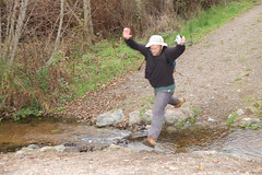
Soon there was a stream to cross, but it was pretty narrow, so I just ran up and leaped across it. Erik generally prefers to slowly step across rocks to cross a stream—rock hopping is the general term, but in Erik's case it is more like rock yoga. But not seeing suitable rocks to step across, he leaped too—and came about one boot length short of making it without splashing.

Past the junction with Bay View Trail, the trail climbed a bit, and Erik pointed out the trees we were passing by: bishop pines. They had pine cones growing straight out of the trunk of the tree, and there were no pine cones to be found on the ground. He told me that they stay on the tree and only open to release their seeds in fire.

We reached a nicely signed junction and started off on Bucklin Trail, which climbs quite a ways to reach Point Reyes Hill at 1,336 feet. Oddly, Point Reyes Hill is 54 feet higher than the peak of Mount Vision, yet only merits the label "hill."


20100107 Mushroom

Bucklin Trail turned out to be a real delight. It is well graded and without many ups and downs (which can add a lot of additional climbing beyond the net elevation gain). Much of it was through a young and dense forest of bishop pines, which formed a canopy over the trail. Erik kept commenting on how densely packed these trees were, and when he got home he did some research. This whole area was burned out in the Vision Fire of 1995, and the young trees grow narrow and close together, but as they get larger, 97% of them will die off, and the larger mature trees will be spaced much farther apart.

20100107 Mushroom on a Forest Trail

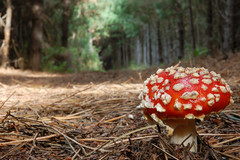
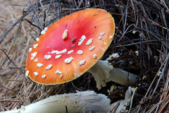
The time of year, the recent weather conditions, and the shade provided by the canopy of trees proved to be ideal conditions for fungi and banana slugs. Over the course of this hike we spotted more banana slugs than we have ever seen on a hike before. But more exciting to me was the profusion of different types of mushrooms. I've never seen anything close to this wide of a variety of mushrooms.
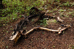
20100107 Deer Skeleton

Deer Skeleton

Given the low-light conditions and the need to use a small aperture to get sufficient depth of field in macro shots, I had to shoot long exposures to get decent photographs, and that was just too much work and too time-consuming for me to photograph every variety of interesting mushroom, much less every interesting mushroom.

As we neared the end of 2.3-mile Bucklin Trail we came to a clearing with spectacular views to the west of a large expanse of the park and ocean. Unfortunately, we were looking into the sun and there was a mixture of fog and clouds, so it didn't look like it would make for a compelling photograph, but it was breathtaking to see in person. To the immediate east it was quite the opposite—a large, fenced-off radar installation on top of the hill used for air traffic control. We hiked alongside this until we reached Inverness Ridge Trail.

Inverness Ridge Trail pales in comparison to Bucklin Trail for hiking pleasure, but it looks like it would be a great trail for bicycles. It was wide with lots of ups and downs. At one point there was a narrow, unmarked side trail. We couldn't resist our curiosity and ran up it to see if it led someplace interesting. It kept going and had another unmarked junction, and at that point we decided to turn back and return to the mapped trail. On the map this area appears to be close to the park boundary and private land, so I'm guessing that this trail might have led there. It's not shown on the full park map or the north district hiking map.

From Inverness Ridge Trail we made our way back to Muddy Hollow Road via Drakes View Trail. As we were heading downhill, I expected wide open views of Drakes Head and Limantour Spit, so as to justify the name of the trail. But we had no such views. It resembled Bucklin Trail, only was generally steeper. As we got to the lower portion, it opened up to a more grassy area with a couple of large wooden arch bridges across streams. On this lower portion of trail I spotted four rabbits. Back on Muddy Hollow Road, Erik redeemed himself by clearing the creek with his leap.

20100107 Leap

In all this main hike added up to 7.1 miles, and we had hiked another 4+ miles out on Limantour Spit in the morning, so I was satisfied with that. I hate to drive such a long distance and do anything less than 10 miles of hiking. There was also quite a bit of climbing for Point Reyes, although not much in comparison to Sierra hikes.

The fact that in all my research of trails to hike in Point Reyes I have never read anything about Bucklin Trail gives an idea of just what a great variety of terrific hikes there are to do at Point Reyes, albeit we may have been very lucky on our timing for the mushrooms and banana slugs. For a day that had started with such low expectations, both Erik and I were thoroughly delighted with our day of hiking.