Some of my photos are now for sale at ImageKind.

Nature Index
(My hiking and camping adventures in Northern California.)

Culture Index
(NorCal cities, highways, restaurants, museums, architecture, historic attractions, vintage neon signs, roadside attractions, etc.)

Sunday, January 27, 2008

Mt. Tamalpais Watershed: Cataract Falls

20080126 Some Stream

When my friend Erik and I hiked a couple of weeks ago, he had hoped we'd be able to do an additional hike to see the waterfalls along Cataract Trail, but the closure of Ridge Crest Boulevard. prevented us from getting there. So this time, we planned to get there from the other side, coming from the east. We cruised down I-80 towards San Francisco, then cut west at Vallejo on CA 37, took a detour into Novato because a portion of the express way was closed, headed south on US 101 to San Rafael, and then drove through several lovely towns of Marin County on Sir Frances Drake Boulevard, finally to Fairfax-Bolinas Road. We slowly climbed up the narrow winding road from Fairfax, only to discover that the road was closed at Meadow Club golf course, more than 5 miles from where we planned to park. I quickly pulled out the map of Marin Municipal Water District's Mt. Tamalpais Watershed, and decided to head back to the turn off for Lake Lagunitas and Bon Tempe Lake, where we hiked more than a year ago with our friend Dana.

After paying $7 for admission, we parked at the Lake Lagunitas picnic area, and I tried to figure out our route for hiking. I remember being totally disoriented when we were here last time, and I was again. I was looking at the map and looking around and checking my compass. Erik also had trouble figuring out which direction it was to the trails on the map.

Finally an older gentleman came over and asked us if he could be of help. We said we wanted to hike to Cataract Falls.

"Oh, that's a long ways off. That's much to far to go in this stormy weather," he responded, seemingly amazed that we'd think of doing it.

Erik asked, "Is it supposed to storm today?"

"This is just a break in the storm."

I asked him about hiking to Collier Spring, which caught my eye on the map.

"Can you pole vault?" he asked us. He went on to explain that there are three creek crossings that are a challenge after rains like the area was recently hit with. He claimed to be the only one to make the last crossing, and described to us how he pole vaulted across it with a long branch in the water.

He told us we could shorten the distance to Cataract Falls by driving down the gravel road we had passed to Bon Tempe dam, crossing that, and hiking down Kent Trail. That looked good on the map, so I decided that's what we'd do.

"But that's got to be about a 10 mile hike!" he warned.

"Yeah, 10 miles. That sounds good," I responded. We've had plenty of longer hikes.

He then suggested that we leave a note telling where we were headed in the car window, and said he would tell man back at the entrance kiosk. Apparently he thought there was a chance of us not making it back before nightfall.

I rushed us off from there, as I did want to give us plenty of room for error in making it back to the car before dark. He definitely wanted to talk some more, and I was sorry to cut it short, since his trail advice proved very useful.

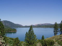
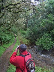
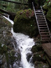
So we parked over at Bon Tempe Lake, and crossed the dam. The spillway had plenty of water flowing down it, and there had been water flowing all over Fairfax-Bolinas Road. From there we headed right on Kent Trail, which was a dirt road at first, before narrowing to a footpath that followed the shoreline of the badly misnamed Alpine Lake.

Along the way we laughed about the man's exaggerated concern for our welfare, repeating some of the things he had said with incredulity. Then I told Erik that this is just how many of the near-death adventure stories in the book I'm reading now, No S*** There I Was, started--people being warned of danger, and not taking it seriously.

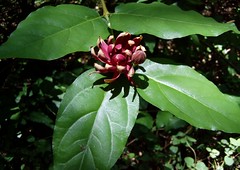
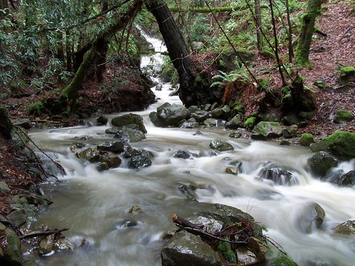
Every little gulch in the hills was flowing with muddy water feeding the lake. It's cool and wet there most of the year, so it is mostly green--the minty, pale green of whatever that is on the white-barked trees, and the deeper green of the moss growing on every available surface.

We were constantly crossing small seasonal creeks, some just easily walked across without any, others that forced us to choose rocks to step across on.

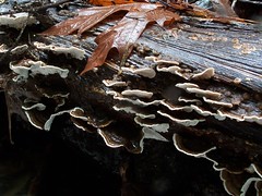
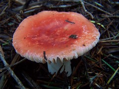
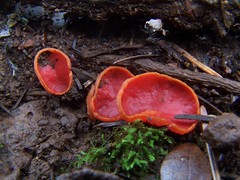
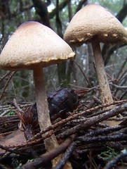
Our route took us 2 miles to a junction with Helen Markt Trail, which we followed. We started to climb and came across masses of mushrooms and other interesting fungi. I was somewhat embarrassed that a man came jogging by while I was lying on the ground getting a macro shot of one.

20080126 Mushroom

Despite the warnings about the distance, we encountered people returning from Cataract Falls. One man told me, "The falls are fantastic," while a woman let me know that I was "in for a treat." None of them looked like serious mountaineers or anything, yet they didn't seem to find the hike a challenge.

And then we came upon our first major obstacle--a creek that looked difficult to cross. Erik was thinking of trying to walk across a large tree that had fallen over it, only the tree was about five feet above the water, and there was a waterfall right after that. My thoughts, on the other hand turned to pole vaulting.

I found a good straight and sturdy branch and stuck it in the water and prepared to make my crossing. Erik didn't think it was a good idea. But it wasn't really pole vaulting. I was at a spot where it didn't take much of a jump to reach the other side. The only problem was that on the other side I would be landing on an uneven, wet rock. I thought the stick would enable me to keep my balance.

I made it across, surprisingly easily. Seeing that, Erik followed, and reported that he also found it surprisingly easy. I'm curious about the people we had seen earlier, and if they had considered the crossing a challenge.

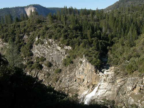
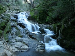
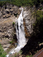
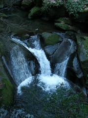
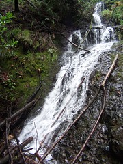
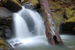
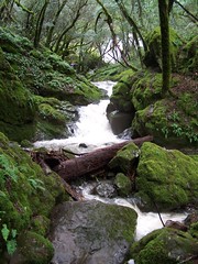
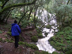
Then we hit Cataract Trail, and a big waterfall. It was impressive and we took some time taking photos, getting long exposures and the like. My thought was to continue up from that junction .8 miles and turn back on another trail. That would mean we would miss the lowest .6 miles of the trail between the junction and Alpine Lake. Seeing how beautiful the cascades looked below, Erik thought we should descend some first, so we did. Then he found someone coming up, and asked about what was below, and his response was enough to assure us that we should continue the full .6 miles before doubling back and climbing steeply up the gulch.

200801263626

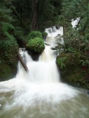
I've never seen anything like it. Water was flowing from everywhere in massive amounts and dropping in beautiful waterfalls and cascades. We walked from one major waterfall along some cascades to another major waterfall, with the water from that joining the water from another waterfall coming down another wall of the gulch. There were plenty of people there enjoying this incredible display at peak conditions.

20090219 Cataract Creek
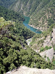
(A photo from our 2nd trip there, a year later.)

We stopped to take pictures frequently on the way down, and then started up. It was a steep climb, and I realized we had taken the wrong approach. We should have sped down, and then taken pictures on the climb back up, when we needed the rest. But instead we just kept climbing at a slow pace.

200801263664

200801263669

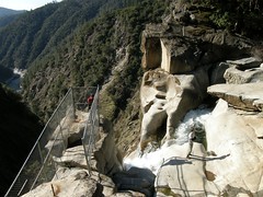
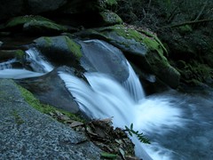
We continued on Cataract Trail past the junction with Helen Markt Trail, and Cataract Creek quickly became calm. I thought perhaps there were no more waterfalls, but that was not the case. They just came more infrequently in the last .8 miles of the trail. The final one, though, was a fantastic one. We saw a photographer with a tripod there, waiting patiently for everyone to leave the viewing area, so he could get a shot without any people in it. That must have been a long wait, as there were plenty of people enjoying the display.

20080126 Waiting for the People to Leave

Here we hit the junction with High Marsh Trail, which I planned on following to make the hike a loop, for greater variety. We quickly climbed up above the gulch, on the side of a steep hill covered with grass. We could see the narrow gulch we had followed below, choked with trees that obscured the creek and the waterfalls and all the hikers from view, a separate world unto itself.

We quickly left the open, grassy area and entered forest, occasionally crossing streams again. We were confused by a couple of trails that led off in other directions, but which were not marked on the map. There were signs there indicating that if we kept straight we would be continuing on High Marsh Trail, but not indicating where those other trails went. I just hoped the last one we crossed wasn't Kent Trail, a small portion of which we wanted to take next. But we soon passed a signed junction that let us know we were on the right path.

And then we had our next major crossing, a raging creek at the foot of a waterfall. Most of the year this is undoubtedly an easy crossing, but after a week of rain, the water was really flowing.

Erik and I rock hop across creeks all the time. What made this more of a challenge was that the some of the rocks we would have to step across were wet, and the water was flowing with enough force that we would likely be knocked off our feet if we ended up stepping in the water, not that there was any danger we would be swept away. I'm just always worried about hitting my head on a rock if I fall.

Erik went ahead and crossed, while I was still searching for an easier route. But I couldn't find one. I followed Erik's advice, holding onto a boulder for balance on the first step, and using the same stick he had used in the water to help my balance on later steps, and finally grabbing his hand to make it to the other shore. I didn't have good balance on that last rock, and might have fallen if he wasn't there. Fortunately, he had decided to help me out rather than film me crossing.

Finally, we hit a swampy area that was the first thing we saw resembling marsh on High Marsh Trail, and were treated to the croaking of frogs. Immediately after, we reached the junction with Kent Trail.

Kent Trail descended a short ways to a spot where the map showed Hidden Lake. But we were running late, having taken a lot of time taking pictures, having done 1.2 miles more of hiking than I had planned on the outset, and having to take time to work our way across obstacles, so I didn't bother looking for Hidden Lake. Not having a map, I don't know if Erik knew there was something to look for.

This was at the junction with Stocking Trail, which we planned to follow to Rocky Ridge Road. It did not seem to be a trail as heavily traveled as the others, and was covered with much storm debris. We had to skirt around ponds covering parts of the trail at points. The second time this happened, we had trouble picking up the trail on the other side. There was a trail running perpendicular to the way we had hiked there, and we didn't know whether to go right or left. Erik thought right, and not having any idea myself, we headed that way, uphill. But while it was clearly a trail, it was far less distinct than anything we had traveled before, and finally Erik changed his mind, and we returned. Going the other direction we soon crossed what was definitely the continuation of the trail we had been on. I don't know what the story is on the intersecting trail, other than it was a trail, but it is not on the map.

20080126 Mushrooms

Started on our way again, we had another obstacle on the short .6 miles of Stocking Trail. It was another creek to cross. This one was not raging, but was broad and fairly deep. There was no rock hopping it either. There was one point at which I could have jumped across easily, had there been a firm launching point, but the mud would have probably slipped out from under me and I would have landed in the middle of the stream.

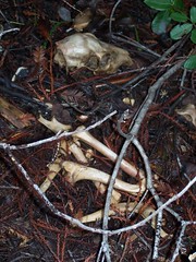
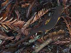
The only danger was getting wet feet and socks, which I have done before (and I carry an extra pair of socks), but we still looked for a way to work around the obstacle. Climbing over some fallen redwoods, I found three piles of bones from a kill, and shortly after saw a newt. Eventually I worked over to a spot where it was easy to step across, and Erik followed.

20080126 Bones

20080126 A Newt

From where we were there appeared to be a trail heading straight ahead, even though we had gone upstream a ways to cross the creek. I started off on it, but Erik thought it would be better if we went back and picked up the trail from where we hit the creek. "You're right," I acknowledged.

We picked our way through the underbrush. We thought we were close to the trail when Erik spotted a shovel leaning against a tree, but we didn't find anything, and soon we had gone farther downstream from where Stocking Trail hit the stream. So we headed back to the trail we had seen before. Traveling a few yards on that, we reached a bridge that made it clear that that was indeed the trail.

I still was confident we would make it back okay. As long as we hit Rocky Ridge Road before sunset, we could easily hike along a road in the dark, especially since I had both a flashlight and a head lamp in my backpack. But I was at the point of admitting that there could be a problem.

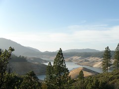
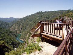
As the trees started to thin along the trail, I could see a rocky ridge up ahead, and hoped it was the Rocky Ridge. And yes, it was, as we reached the junction with the road. Although it was a road in an open area, it was still pleasant to hike on. There were views of San Pablo Bay, and one of the lakes just below us--probably Bon Tempe. And we saw bobcat prints in the mud.

We made it back to the car a little over 6 1/2 hours after setting out, on just a 10.4 mile hike. But we still had half an hour before sunset, and hadn't been touched by a drop of rain during this "break in the storm." In the end, I felt sort of cheated out of the opportunity for an adventure worthy of retelling by saying "No shit! There I was . . . ."

Sunday, January 20, 2008

Plumas National Forest: Feather Falls Trail

20080119 Above Feather Falls

When I last went hiking with my friend Erik, I did little to prepare myself. This time, I did even less preparation. I didn't even get directions to the trailhead. I just grabbed California Hiking on the way out the door.

I was running late, but thought I still might make it on time to pick up Erik--until I stepped out the door, and saw frost all over my car. I was 5 minutes late, and Erik was already standing outside when I got to his apartment. I quickly cleared everything off the passenger seat for him and handed him the book, and we were on our way.

I had hiked to Feather Falls once before, so I didn't expect any trouble, despite my lack of preparation. We headed up the Central Valley on I-5, then CA 99, then CA 70 to Oroville. From there I needed the directions in the book. We headed east into the foothills, and passed by Lake Oroville, which looked like it was nearly empty.

20060702 Lake Oroville
Lake Oroville in July of 2006

20080119 Now
Lake Oroville in January of 2008

At the trailhead/campground, there were just a couple of cars--quite in contrast to when I hiked this trail in 2006, but that was in July. It was crowded then. There's a good reason so many fewer people were there that day--it was cold. I put on a knit hat, and packed a second jacket in my backpack, just in case.

We headed off on the trail, which only goes a short ways before dividing. Either way you go you will meet up with the other spur for the last short climb to the Feather Falls overlook area. One way is shorter, 3.3 miles, but has greater elevation changes. The other way is more gradual, and about 4.5 miles. Both are more downhill than uphill on the way out. In 2006, I chose the shorter way out, and then hiked back up on the more gradual route. This time we went the opposite way, just so I could have some variety.

Since it was summer when I hiked the trail in 2006, I had the chance to see more plant and animal life then.

20060702 Lizard

20060702 Unidentified Tree
2006 Photos

This time we didn't hear much for birds, or see any lizards. But we often had the sound of a creek . . . or me talking about old highways, or Erik talking about politics.

While it's the Feather Falls Trail, there are more waterfalls along the route. There's one sizable one on the longer route, with a bridge across the creek just below it, the perfect place to take a picture. I don't know if the waterfall has a name, but I believe it is on Frey Creek.

200801190138

Not long after that we joined the other spur, and started a fairly steep climb, then a very brief descent. With massive Feather Falls in sight through the trees, the trail reaches a junction. One way does a U-turn, and is signed for the overlook. The other way is unsigned, and is not shown on the map at the trailhead.

We took this other route. In 2006 I went the other way first, and from the overlook could see people sun bathing on rocks just above the falls, and saw a chained link fence securing an area just at the edge of the cliff. I went the other way to try and get down to that area, and couldn't find it. This time I hoped for better results.

The trail leads over initially to an area just above the Fall River. It was easy to spot the use trail down to that area this time, but it was faint, and would be harder to find in summer with bushes in full foliage.

The trail over to the general area is an official trail, and continues a long ways past Feather Falls. But the several little use trails down to Fall River are not official. This is a dangerous area, as several people have been swept over the falls to their deaths. We saw a man jump across the river here, and jump back. But in 1967, a young boy jumped to a rock in the river, slipped, fell into the river, and was swept over the falls.

We were far more cautious than the man who jumped across--there's no better view over there anyhow, so it's certainly not worth the risk. We slowly worked our way over to the fenced off area. This is right at the edge of the falls, and it is a nice view down. In order to get a photo without the chainlink in it, I had to just hold my camera above the fence and shoot down. The results were disappointing. The lower part of the falls and the canyon below were all in shade, so the image just shows white water flowing into darkness. It looks as though it could be a 5 foot drop, when it is actually a 640 foot drop. Yes, 640 feet, making it the sixth largest waterfall in the United States.

20080119 On the Precipice
Erik on the Precipice

After leaving the fenced off area, I climb up above it, in search of more views, while Erik took photos from where I had just been. A couple arrived at this time, and waited for Erik to finish so they could have their turn.

Leaving the falls, we went farther upriver along the trail, just to see where it led. It parallels Fall River, with many more use trails down to the water, with some spots looking like nice campsites. Certainly somebody camped where we finally stopped and turned around, as there was a fire ring and an iron frying pan--as well as boots and jeans and various other garments that had been abandoned.

We took some pictures of the river here, then returned to the junction, and this time headed out to the overlook. The overlook itself is a substantial structure built on a rocky outcropping with a full view of the waterfall. There were quite a few people here, coming and going. Several couples handed over their cameras to strangers to get pictures of themselves in front of the falls.

20060702 Viewing Platform
The Overlook

20060702 Feather Falls
Feather Falls

This video should give you a sense of scale:


Feather Falls from tspauld on Vimeo.

There is also a nice view down the canyon in the opposite direction. When I was there in 2006, I could see boats that had come up Lake Oroville, all the way to the point at which Fall River empties into Middle Fork Feather River. This time, that area had large rocks exposed by the low water level.

20060702 Middle Fork Feather River
Lake Oroville Boats

After eating our lunches and enjoying some of the warm sunshine at the overlook, we headed back. As we made the short climb away from overlook and were about to start down again, I noticed a trail leading uphill to the west. We decided to follow that to see if there were any more interesting views of the falls from up there. We got up to a campsite, then followed an overgrown trail a short ways to another, more clear trail. We continued on, catching glimpses of the falls through the trees. Eventually we got away from the sound of the waterfall, and realized if there were any more views, we would have to hike a long ways for them, so we turned around. At one point on the way back we went down the slope off trail a ways to where there was a less obstructed view (the picture at the top of this blog entry).

We got back onto the main trail, and quickly down to the fork, where we took the shorter route this time. The longer route had a view of it as well, but the shorter trail has a better point from which to view impressive Bald Rock Dome, with a sign explaining how it was formed.

20060702 Bald Dome
Bald Rock Dome

Although it has more ups and downs, we could have sped back to the car on the shorter trail, but instead took another diversion. This trail runs above Frey Creek for much of the way, and crosses it. Before we reached the crossing, we spotted another nice waterfall through the trees. There was evidence of where people had climbed down the steep slope for an unobstructed view. I asked Erik, and he was all in favor of doing the same.

200801190196

We had to scramble a bit, using our hands, sliding on our asses, but it was quite a lovely little waterfall. After taking some long exposures--using my backpack in place of the Gorilla Pod I had stupidly left in the car--I headed back up, while Erik continued to take pictures. But up at the trail again, I spotted another area part way down that looked like it had a nice overview, so I went there to take some shots. I showed one of the pictures to Erik once he climbed back up to the trail, and he decided to head back down to the same place.

200801190213

The last stop we made on the way back was at a sign in front of some large boulders with mortars in them carved out by the Maidu.

20080119 Maidu Mortar
Maidu Mortar

With all of the diversions, it was probably about 10 miles of hiking, and we were out there almost 5 1/2 hours. It was so nice to change out of my boots and back into my sneakers back at the car. We continued to take our time on the drive home. We stopped at an old drive-in restaurant in Oroville, where I had a splendid burger, and I pulled off the highway to show Erik around the interesting old downtown area in Marysville. What had started out in a frantic rush in the morning turned out to be a relaxing and enjoyable day.

Wednesday, January 9, 2008

Marin County: Steep Ravine Trail & Stairstep Falls

Neither my friend Erik or myself had been hiking in over two months (although I did take one camping trip in the interim). So we had plenty of time to plan this hike. We didn't.

Usually I plan the hike, as I have several hiking books and know many useful websites, and have the National Geographic mapping software. But I was busy researching old buildings in Sacramento for my non-hiking blog entries, and I just told Erik to check waterfallswest.com to find a good waterfall hike (to take advantage of our recent storms) at low altitude. He came up with the Steep Ravine Trail in Mt. Tamalpais State Park, and came up with another short hike that we could do if we had time. I thought that sounded great, and told him I had the information and the map for the first hike, and for him to bring the information for the second.

We got off to a slow start, as I was unprepared. After picking Erik up, I had to stop for gas, then for a breakfast burrito. Then we took a back route to bypass downtown Sacramento during rush hour. And there's just no getting around the fact that it's long drive to much of the coast from Sacramento.

We drove down to Vallejo, headed over on CA 37 just north of San Pablo Bay to Novato, then south on US 101 to Mill Valley, then north on CA 1 to just yards away from Stinson Beach, where we turned on the Panoramic Highway.

And then I think we drove right past the Dipsea Trailhead that we should have started at, to follow the directions from waterfallswest.com. We went up the winding a road a ways until I saw a gate with some trail signs beyond. They indicated Dipsea Trail and Steep Ravine Trail, so we started our hike from there.

20080109 Erik Shoots
Erik Shooting

It wasn't long until we were in Steep Ravine, passing the junction for Dispea Trail, and what a beautiful location it is, particularly after recent rains. The trail follows the creek, with many small plunges producing plenty of white water, and a fewer longer falls. We were stopping to take photographs frequently, although the low light conditions on an overcast day made things challenging for us, as neither of our cameras can do a very high ISO.

20080109 Banana Slug
Banana Slug

20080109 Cliche
Small Plunge

One of the things I was most looking forward to in the hike was the ladder--a portion where you have to climb a ladder up a steep rock face. Despite a warning sign about it .8 miles in advance, it turned out to not be much of a challenge. Erik was disappointed, complaining about the fact that it wasn't even completely vertical, but was on an angle.

20080109 The ladder we were warned about.
Easy Ladder

The hike climbs to the Pantoll Ranger Station, where there is a parking lot and a couple of roads. Looking at the map there, I saw that we left from the wrong starting point. If we proceeded according to the directions, we would go all the way down to CA 1 on Matt Davis Trail, then climb back up on Dipsea Trail to where we had parked. Erik was anxious to see the cascades on the other hike, so he opted to simply take the Dispea Trail back to where we parked to complete our loop in a much shorter distance.

So we just had to find a trail down to Dipsea Trail, and I finally spotted what turned out to be TCC Trail, which I have been on before. With all the recent storms, there were downed tree limbs and needles all over the trail, and a few times Erik questioned whether it was a trail, or whether it got much use. But I just marched on.

We got down to the signed junction with Dipsea Trail, and headed down on that. At first, the scenery was quite subdued. Had it been a clear day, we might have had wonderful ocean views--but it wasn't. Only when we got close to the junction with Steep Ravine Trail did the setting become enchanting again.

20080109 Bridge
Bridge to Dipsea-Steep Ravine Junction

We were soon back to the car, and headed up to Pantoll Ranger Station to take a road from there to our next hike. But farther up, the road was closed, due to dangerous conditions. So we had to find my Bay Area map to find an alternate route. We settled on the Fairfax-Bolinas Road, which crosses CA 1 right at the north edge of Bolinas Lagoon.

Somehow we missed it. We drove all the way to Olema, and Sir Frances Drake Blvd. Erik let out a groan of disgust when we realized how far off we were, but there was no need to be disappointed. There are splendid trails all over this area. I suggested to Erik that we continue on Sir Frances Drake Blvd. to Samuel P. Taylor State Park, and revisit the site of a waterfall we had been to 50 weeks before.

Last January we hiked up to the top of Barnabe Peak, and took a small side diversion signed for a waterfall. But last year was unusually dry, and there had been no recent rains before our visit. There was a big drop-off at the end of the trail, but no water coming over it.

Erik was fine with that, so we pulled over in a parking area opposite the trailhead, and headed up the easily graded trail. There was one major obstacle in our path, where some trees had fallen on the trail, without there being any way around them. We had to twist and turn and hunch and stride to get through them.

20080109 Stairstep Falls
Stairstep Falls

At the end of the trail, we had a lovely waterfall. Although it turns out we might have gotten more out of the short hike.

20080109 Shrooms
Mushrooms

One the way back, we ran into two men with a bunch of kids, and one of the men asked if we had spotted any salmon in the spring. We hadn't been looking. Later on, we met a young man, who asked the same thing. I didn't think it was salmon spawning season, although there were signs on the trail about salmon. We did watch after that, but didn't see any.

And then it was the long drive home. Mercifully, traffic wasn't bad at all.

Not having hiked in more than two months, I had almost forgotten just how delightful it was. Last summer I swore not to let a week go by without me getting in a hike, and returning from this hike with a spring in my step and a general feeling of well being, I wondered why I hadn't made greater efforts to hit the trails the last several weeks.