Some of my photos are now for sale at ImageKind.

Nature Index
(My hiking and camping adventures in Northern California.)

Culture Index
(NorCal cities, highways, restaurants, museums, architecture, historic attractions, vintage neon signs, roadside attractions, etc.)

Monday, December 31, 2007

The Mendocino Coast: Russian Gulch State Park

20071020 CA Route 1 Bridge

Although I love to explore Northern California, my budget has limited me to day trips. To overcome this, I invested in a tent in July of 2007, and this was one of my first excursions with it.

I set off Saturday morning without even knowing how to get where I was going. I remembered a previous trip along the north shore of Clear Lake, and seeing signs for US 101 before that, and I figured that route would get me to the Mendocino Coast. So I took I-5 from Sacramento to Williams, then headed off on CA-20.

The drive up I-5, well familiar to me, was monotonous. Many small towns were announced as exits, but I've exited and investigated them in the past, and been disappointed. The Sutter Buttes began to appear on the right-hand side, reminding me of how close I was to Yuba City and Marysville, only they were to the east on the old Highway 99E route, while Intersate 5 follows the old Highway 99W route.

At Williams, everything changed. I left the freeway to follow CA-20, and started heading towards that coastal range that had paralleled my drive north. I've made this part of the drive once before, and had the same exciting experience I had this time. As the distant border to the valley approached, it became more interesting, and more real.

From a distance, it is a solid wall, but as you approach it, you see that it is not impenetrable to the automobile, although much of it is, thus the limited number of roads that wind their way through the coastal range. It is an undulating range of hills, with winding passages that one can climb relatively gradually. It was, both times, typical of a Northern California summer landscape, all golden hills dotted with oak trees.

Soon after passing the Oasis Grill, a place that from the looks of it I have to try some day, I came out at Clear Lake. That means following winding CA-20 along the north edge of CA-20 through resort communities, with variable speed limits, and usually some slow tourist driving in front of me well below that speed limit.

Once past the lake, it's a quick trip to US 101, which is beyond what I had traveled on this path before. I just assumed I would keep heading towards the coast, but found myself merging onto US 101 South, headed towards San Francisco. I took the first exit and for the first time checked a map.

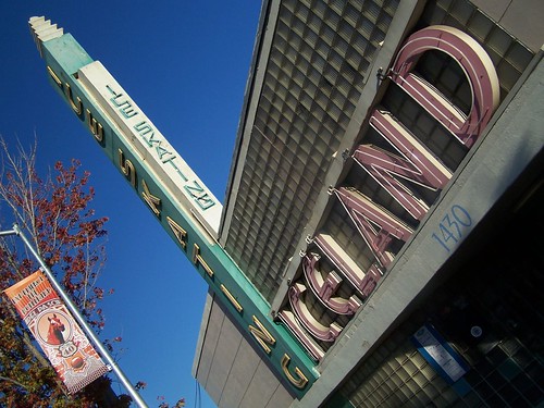
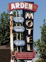
I needed to head up US 101 North to take follow CA 20 West at Willits, so I did. Soon US 101 ended as a freeway, and turned into a two-lane highway. In Willits I saw one of the vintage motel signs I love to find, only I had already seen it before on Flickr, so my excitement was tempered. I still stopped to photograph it. Willits also has one of those lovely banner neon signs declaring the town's identity. Willits is apparently the "Gateway to the Redwoods." From my experience, that is accurate enough.

Heading west on CA 20, I came upon a winding stretch of road that caused me to ride the brakes often. The road twists back and forth through Jackson Demonstration State Forest, with towering coast redwoods casting everything at ground level into cool darkness. What is a demonstration forest? I have no idea.

Coming out of the Redwoods I approached CA 1, the Shoreline Highway, just at the southern end of Fort Bragg. I took a quick tour of Fort Bragg and fueled up, both with gasoline and lunch, before heading south along the coast to my destination, Russian Gulch State Park.

The park is named after the gulch and the river of the same name that runs through it out to the Pacific Ocean. There is a nice beach at the river outlet, dramatic coastal views, and acres of redwood forests filled with hiking trails. The highway crosses the gulch on a lovely arched bridge, which the one-lane road to the campground passes under.

I picked out my campsite, paid my $20, and set up my tent. Then I put on my hiking boots and headed off in the direction of the Fern Canyon Trailhead, but before I reached it, I saw the trailhead for North Trail. Checking the map I got from the front kiosk, I saw that this slightly longer trail meets up with Fern Canyon Trail and the Waterfall Loop trail that was my objective, so I started out on it, immediately climbing up switchbacks.

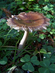
I set out at 3:00 and wasn't sure what the total distance was on this hike, so I was anxious to hike quickly so as to get back before it got dark, although I did have my new Gizmo headlamp with me. So I pushed myself, only stopping to photograph a mushroom. There were many mushrooms.

20071020 'Shroom

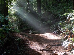
After the initial climb, the trail was flat, passing through the redwood forest. Redwood forests are always lovely, and if you haven't ever been in one, it would be reason enough to go. But I've hiked in them a number of times, and I had never visited the dramatic Mendocino coast before this trip. So as I reached junctions with other trails, I would check my map and my watch, and try to determine if I could get back in time to make it to the ocean by sunset.

After a long stretch of flat trail, I started descending, gradually at first, then more steeply. I could see the Fern Canyon Trail below--it is wide and paved. I reached the junction with it and the Waterfall Loop Trail, where there are bicycle racks and a picnic table. Bicycles are allowed on the Fern Canyon Trail, but not on the the Waterfall Loop Trail.

The sign showed one direction to the waterfall at 2.3 miles, and the other at .7 miles, so I took the short way. The trail involved a little more climbing, and was a bit sketchy for the non-hiker at points, with slick areas next to a steep drop-off, and some spots that had been eroded away entirely that I had to carefully pick my way around.

20071020 Russian Gulch Waterfall

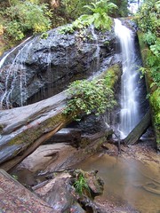
The waterfall was all that I could hope for, and was flowing nicely. I set up to take photos of it with my Gorillapod. It was much too dark in the redwood forest near sunset for a handheld shot. As I was shooting, a couple arrived with a tripod and a nice DSLR camera, and another couple soon arrived as well. I got to take a photo of the first couple with that DSLR.

20071020 Shaft of Light

I headed back the way I had come, the short way, rather than taking the loop. Once back at the junction, I took Fern Canyon Trail, which was signed as being a mile shorter than North Trail. It was also totally flat and paved, and I made good time. Such good time, in fact, that I made it back to the campground well before sunset.

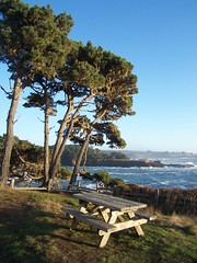
I made it back early enough that I decided to run down to the town of Mendocino, two miles away, to pick up something to eat for dinner (which I had neglected to do earlier). Back at the park, I headed off to a picnic area I had not visited before to walk along the coast and get some shots as the sun went down. Afterwards I parked back at my campsite.

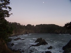
From there I headed off to a trail marked on the map along the edge of the coastline. I overshot it at first, and instead caught the sunset framed by the Shoreline Highway bridge (the photo at the top of this entry). I headed back and found it, along with a warning about this being mountain lion territory. Normally, I wouldn't be concerned, as I generally hike in the middle of the day. Mountain lions prefer to hunt in the dark, or in dim light, when their sensitive eyes give them a great advantage. That's why my cat tears around my apartment in the middle of the night. But it was dusk already, so the warning was a bit of a concern.

20071020 Dusk @ Russian Gulch State Park

I hiked up a muddy and steep, but short, portion of trail, and crossed under the bridge, where there was graffiti featuring aliens. On the other side I soon came out along the coast with what I believe were cypress trees. I took a few pictures then headed back to camp. Just as I was about to reach the trailhead, I crossed a slick wooden bridge of sorts, and my feet slipped out from under me, by about a foot. My arms shot out so quickly that it hurt and I flailed my arms about, and somehow managed to not fall.

Back at camp in the dark, I chose to eat my sandwich in my car so I could turn on the radio and check on ALCS game 6 between Boston and Cleveland. The sandwich from Harvest Market, a frittata made with pancetta, onions, spinach, basil, sun-dried tomatoes, feta cheese, and garlic aioli, was one of the most delicious things I've ever tasted, although it was too big too finish. And my team was up 10-1 in the third inning, so I was feeling good.

I got even less sleep that night than on my last camping trip. When I was 17 I just threw my sleeping bag on the ground in the open air for a 4-night trip with my friends from high school, and had no trouble sleeping all night. But now my chronic back pain of 6 years makes it difficult to sleep even with a pad under my sleeping bag and a pillow. I'm not giving up, though.

As soon as there was the first hint of light, I headed out to brush my teeth, pack up my things, and disassemble the tent. I couldn't pack the tent away, as it was all wet. This time of year, everything in the park is damp all of the time. I just threw it loosely in the back seat to dry in my greenhouse on wheels, with the windows cracked slightly to let the evaporated moisture out.

I then repeated the two coastal hikes in the park I had made yesterday, only going farther, starting from the picnic area. Although it was light, the sun had still not popped over the horizon. I went out to a fenced-off area. The ground dropped away beyond the fence in a deep into a wide whole in roughly circular shape, at the bottom of which waves were surging in via a tunnel to the sea. An underground cavern had collapsed here, apparently. I'm afraid my photos didn't turn out well, so you'll just have to visit this natural wonder yourself. Walking back, it was a bit disconcerting knowing that there was a tunnel beneath me at some point flowing with water, that will inevitably collapse some day.

20071020 Picnic Spot

As I got back to the point of this small peninsula, I could see out a ways that the light was hitting the very top of the waves. The evening before I had seen the waves beating down ferociously and endlessly on the rocks, wearing them away. That morning it seemed to me that they were using the rocks as a springboard to leap into the air with delight to greet the return of the sun.

I returned to make the hike along the path with the warning about mountain lions, only this time I continued along the other side of the small peninsula back to where the trail closely parallels the highway before reaching a parking lot and heading out again. A couple of portions of trail had been eroded away, one requiring me to drop down and climb back up, and the other that I was able to jump across. From the parking lot I went out on another small peninsula before heading back.

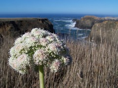
My original plan had been to head to Van Damme State Park and take a longer hike into the redwood forest there, but I decided I would rather see as much of the coast as possible. So I headed down to Mendocino State Park, and walked all along the coast line there. There was only 1 vehicle in 1 of the 3 parking lots when I arrived, but people began arriving in large numbers as I kept walking. The ocean here is filled with large rock outcroppings that the waves beat upon and the birds alight on. There were many natural arches and caves. On the other side, the town of Mendocino was always visible.

20071021 Mendocino Coast

From there I headed to Big River State Park, where Big River empties into the ocean. I must have been there close to low tide, as there was a massive beach. Then it was to the beach at Van Damme State Park, where there were many surfers and kayakers apparently getting ready, but none out on the water. Next, an overlook on a public easement. Then Navarro Point Preserve and Scenic Trail. If it feels like I'm rushing, it's because I was. I wanted to see as much as possible, but I also wanted to get home, especially since I was so tired from lack of sleep.

20071021 Little River Empties into the Pacific

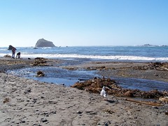
As I was approaching the junction with CA 128, which I planned to take back on the way to Ukiah, US 101, and CA 20, I came down a ridge with a dramatic view of an expansive beach and a river headed towards the ocean. It reminded me very much of Jenner and the Russian River, only without the town perched on the river. Rather than head off immediately on 128, I took a short jaunt over to Navarro Beach, part of Navarro River Redwoods State Park. This is where the Navarro River usually empties out into the Pacific Ocean, but at low tide, it was dammed up by the beach. Presumably the water would eventually build up enough to cross that stretch of sand, if the rising tide didn't breach it first. The other notable thing about this beach was the amount of driftwood. I've never seen anything anywhere approaching that amount of driftwood in my life.

Leaving the beach, I drove through the rest of the park. Like in Jackson Demonstration State Park, the road weaved through a redwood forest, but this time the curves and grades were far more gentle, and I didn't need to use my brakes. The road came out of forest into an agricultural area filled with vineyards and wineries and orchards and pumpkin patches.

On the outskirts of Booneville, I took a left on CA 253 over to Ukiah, a winding road with a stretch of 10% downhill grade. Just south of Ukiah, I got back on US 101, headed north to CA 20, stopped on 20 at Foster's Freeze in Lucerne for chili cheese fries and a shake, then went on to I-5, then south on I-5 to Sacramento, exhausted from the long journey and anxious to sleep on a soft bed.

Saturday, December 29, 2007

Tahoe National Forest: Bearcroft Trail


North Fork American River from Elund on Vimeo.

Having just made a trip to my grandmother's, I didn't want to put many miles on my car for my next hike, and I wanted it to be relatively quick, so I could get home with plenty of time to get ready for work the next day. But I still wanted a good workout. Consequently, I proposed to my friend Erik that we hike Bearcroft Trail to the North Fork American River, describing it as a "short, butt-kicking hike."

Only after I picked him and we were headed out on the freeway did I define what I meant by that. From the trailhead to the junction with American River Trail, it's just 2.25 miles of descent. But the total descent is 3240 feet, for an average grade of 28%. I've been hiking progressively more difficult trails down to the American River. I started with Stevens Trail, 4.5 miles long with 1200 feet of descent, then it was Euchre Bar Trail, 1.8 miles long with 2000 feet of descent, then Mumford Bar Trail, 3.25 miles long with 2640 feet of descent.

We exited I-80 in Auburn at the Forest Hill Road exit, and proceeded on Forest Hill Road, crossing the river we were going to visit later on a high bridge, from which there are probably lovely views, if you have a car not so low to the ground as my Chevy Metro. The road passes through the small, old town of Forest Hill before entering Tahoe National Forest, at some point becoming Forest Hill Divide Road. There's nothing but trees and the occasional trailhead along either side of the road, with occasional glimpses through the trees of the deep canyons on either side of the ridge.

We pulled off at the signed turn-off for Bearcroft Trail, where there was a sign with an image of a car and the words "NOT ADVISED." But I think that is just if you drive past the small parking area that we reached immediately and farther along the road. Certainly we had no problem.

The descent does not begin immediately. We hiked along a rough road a short distance to a sign that said "BEARCROFT TRAIL" and pointed left. There appeared to be a trail right next to it, and another farther left. We took the one farther left, which had some other sort of sign on it.

We made a slight ascent to the top of the canyon's edge, then came to a gully where we had our next dilemma. The trail appeared to head across it, but then it wasn't clear trail on the other side. I was marching across it when Erik spotted a cairn down the gully. So we headed that way and found the trail. Other than the fact that pine needles and fallen leaves covered much of the trail, we had no problem following the trail after that.

Soon we began the descent, which was, as expected, steep. I've climbed many steep sections of trail, but never one so continuously steep. Most steep portions of trail I have been on have been rocky, like an irregular stairway. This one was just a vicious slope, like the world's most dangerous wheelchair ramp. We exchanged several jokes about the difficulty of the task ahead of us.

The trail is in heavy forest, with only occasional glimpses of the wall on the other side of the canyon, which to my inexperienced eyes, seemed to be composed of volcanic rock. That would explain how the river cut such a deep canyon through the area, and why it was so heavily forested, as opposed to the far more resistant granitic terrain of the Desolation Wilderness or Yosemite National Park.

About half way down, we reached a small open, rocky area with dramatic views of the canyon. Soon after we reached an area with water trickling down, filled with ferns and littered with the yellow leaves of deciduous trees. Meanwhile, I was working up quite a sweat. I've never sweat like that hiking downhill in the shade before.

Eventually we got to the point that we could see water flowing below, and shortly after that a bridge. We took the water to be the North Fork American River, and the bridge to be one crossing it. We were suprised that such a substantial bridge was built in such a remote and difficult-to-access location.

Then we reached a sign, indicating that we had reached the American River Trail. Following my hiking book's advice, we headed to the left, down past a nice camping area to the river. Down at the river, we found a dramatic sight, where the river was slowly carving it's way through granite, leaving rounded granite walls rising up on both sides of the river, and a couple of small waterfalls. Upstream from that, the river was broad, wide, and shallow, with an island of rocks in the middle, and many rocks protuding above the water's surface, but it all narrowed down to a chute with about a 10-foot drop at this resistant granite outcropping. On the other side of the canyon, a dark, porous volcanic wall loomed high above us. I would have like to have taken a photo that capture it all, but I would have needed a fish-eye lens for that.

I stopped on that granite to eat. When Erik joined me I mentioned that I hoped the plant right next to me was not poison oak. There's a lot of poison oak along the American River, and I got rashes twice last winter hiking in the area. But I don't know how to identify it. It comes in many different looks, and from the descriptions I have read, most plants look like poison oak to me.

Erik was very interested in the rock formations downstream, and crawled out on a precipitous point to see more of them. I was interested in a tiny waterfall in front of me, and the larger roaring one partially out of sight above it. Because it was out of sight, I started my working my way upstream to try to find a place to rock hop to the island, and then see if I couldn't rock hop to the other side of the river to get a better view of it.

I found a lot of places where it was very close to being safe to go across, but none I felt truly comfortable with. I started back as Erik was heading my way, and explained my purpose. He started helping me, and we soon found a reasonable candidate for a crossing. To make it easier, I found a good stick for support.


The Big Climb from tspauld on Vimeo.

Erik started across first, as I shot a movie of him. But he stopped at a difficult point, and I stopped shooting. To add to the difficulty of this crossing, our knees were a bit shaky from that relentless descent. He eventually made it across, and threw the stick back to me, although it didn't quite make it. I crawled out on some rocks to retrieve it, and started my way across. The only difficult part was where Erik had paused, where I had to stand on one slippery rock, use the stick in fast flowing water for support, and step over to another rock.

Once on the island, I started upstream along the other side of it, finding much the same situation: plenty of places where it seemed possible to cross, but it would be more of a challenge than I cared for. Finally, at the beginning of the island I saw that the river was really broad and shallow, and I could walk across without ever going ever stepping in water more than an inch deep, and my hiking boots have a waterproof Gore-Tex liner, so I crossed that way. Erik followed me, crossing in leather boots that were not waterproof, but only getting his feet slightly wet.

Once on the other side, it was not simple. We had to work our way back downstream through the brush and across rocky terrain. Walking through the brush I remarked to myself that I was sure to get poison oak now.

Eventually we go back to the dramatic chute where the wide, lazy, and meandering river is forced into a narrow, rushing, and violent flow. I set up to take shots of the waterfall, but the conditions were difficult. It was all in shade, while the rock right next to it, and in the view of the camera, was in direct sunlight.

Erik wanted to work his way down to the water's edge. I told him to go ahead, but I wasn't going to, because we had so much work ahead of us to get back. He decided to skip it too. I suggested that rather than rock hop, we go up to where that bridge was and cross there. Erik wanted to cross closer to where we were at, but I said that we had already checked this area from the other side, and it wasn't going to look any better from this side.

But starting upstream, I too had the urge to try and cross where we were at. It was so temptingly close to being crossable. I found a good spot, and threw in a large rock to make it easier to cross, although neither of us ended up using that rock. Erik went first, using the stick we had used before, and another one I found for extra support. I followed him and found it surprisingly easy to cross over to the island.

Then we went back to the same spot where we had crossed to the island the first time. I went first this time. Rather than stepping onto that slippery rock, I decided to just jump up onto the large boulder beyond it. Although I had both sticks, I didn't end up using either one. I threw them back to Erik, and he crossed, using both sticks, and taking my hand as he stepped on that slippery rock. Neither of us shot any video on this crossing.

We went up back to the trail, hiked to the junction, and then went a bit farther to that bridge. I got to it first, and shouted back to Erik, although he didn't hear what I said. As he came up on it, I repeated it: "It's a good thing we crossed where we did, because this bridge doesn't cross the river." It spanned a dry river bed where a seasonal creek must be a raging torrent in the spring, but where there was not a drop of water that day. Had we followed my initial impulse, we would have had to hike all the way upstream, and then return downstream to cross where we ended up crossing anyhow.

We headed back to the junction and began that 3240-foot ascent. At first, I did a great job of pacing myself. But eventually I started to push myself. I was doing fine on the average grade, but every once in a while I hit a much steeper portion, at the end of which I would have to pause and catch my breath and wait for my heart to stop racing and return to a more normal pulse.

At the wet area with ferns, I saw a banana slug crossing the trail. I got down on the ground to take a photo, but by the time I got set up, the slug was going behind a leaf. When I removed the leaf, the slug went into defensive mode, and pulled its eyes and antennae in. I waited for them to cautiously come back out again.

On and on, the slow climb continued. At the clearing I estimate is about half way up, I stopped to sit and look at the view and watch the patterns of shadows of the clouds on the canyon wall on the opposite side of the river, and wait for Erik to catch up.

Returning to the trail, I stopped at the top of one of the steepest stretches to shoot a video of Erik coming up it. He huffed and puffed appropriately, but with my camera pointing down, you can't tell in the video how steep this portion was. It looks like he is laboring over slight incline, but believe me, this was one of the toughest portions of a difficult trail.


The Big Climb from tspauld on Vimeo.

With that out of the way, it was just a matter of plodding on, eagerly awaiting the signs that we were getting close to where we started.

I don't know about Erik, but I was intensely sore for a few days, and could still feel it after 6 days, making it my most intense climb to date. I can't wait to top it.

Monday, December 10, 2007

US Route 40: North Sacramento's Del Paso Boulevard

20071008 Experience the Boulevard

[Note: This will be under construction for some time, as I take more photos and do more research.]

Of all the old highway routes in America, the one that interests me the most in the old Highway 40 route. In California, it followed the route of the Lincoln Highway, the first coast-to-coast road, and cut right through the heart of my adopted city, Sacramento. I'm particularly interested in the design and architecture from the 1920s through the 1940s, and one of the richest historical areas for this in Sacramento is the North Sacramento portion of Highway 40 on Del Paso Boulevard. I first noticed this area when traveling to Arden Fair Mall from Davis via a series of bus and light rail connections, with Lil Joe's and Cardinal Lanes across the street from each other where the bus turned being what caught my eye. In 1999, I finally bought a car and was able to visit the area. In 2002, the year that Lil Joe died, I moved to the Arden Arcade area, not far from the neighborhood, and got to know it better.

North Sacramento was at one time an incorporated city separate from Sacramento, and it even had its own newspaper, the North Sacramento Journal, although it was never a daily publication. The neighborhood flourished in the Art Deco era, but was still in the process of developing after World War II when the automobile and freeway explosion changed the face of America, particularly in California. A recently-built city designed to pre-WWII standards suddenly was bypassed by the freeway in 1947, the first freeway in the Sacramento area. The ironically named North Sacramento Freeway sped people past the small city to vast suburban tracts in Arden Arcade, Carmichael, and Citrus Heights. The local retailers accessible by foot went out of business, as huge supermarkets with large parking lots sprang up, and air-conditioned shopping malls put traditional shops out of business.

With all of the massive suburban growth northwest of the downtown core of Sacramento, there was a lot at stake in deciding how to deal with it in terms of government. North Sacramento was, according to the recurring articles in the North Sacramento Journal, constantly considering annexing new neighborhoods. But then the question arose about what the relation of North Sacramento and Sacramento would be. Twin Cities? A merger? Or possibly a separate city of North Sacramento, almost entirely surrounded by Sacramento.

Those who had developed North Sacramento in the first place and controlled it politically were very much invested in keeping North Sacramento separate. Some who made their livelihood there, like "Lil Joe" Halawe, on the other hand, felt a merger with Sacramento would loosen the tight control certain individuals supposedly had on the area, and was the only way to address serious, long-term problems.

The battle over the merger was bitter, as it was played out in the pages of the North Sacramento Journal, with the publisher not hesitating to report as fact propaganda against the merger, and freely slandering anyone in favor of the merger. After the 1963 election the triumphant headline "MERGER LOSES" ran, although it was close, 1759 against, 1657 for. In 1964, the proposed merger went up for a vote again, and passed--by 15 votes.

Many people consider the merger to be responsible for the continuing decline of the neighborhood, with the city neglecting this area. Whether that is true or not, incorporation into Sacramento certainly did not solve the major problems. The Del Paso district took a major downturn in the 1970s, with many buildings abandoned, and an ever-escalating crime rate. It bottomed out in the 1980s.

Starting in the 1990s, an effort has been made to develop it as an art district, spearheaded by IMG Home and Limn. More recently, New Faze Development has been a major developer in the area. But as recurring articles on the redevelopment efforts and disappointments in the area in the Sacramento Bee and Sacramento New & Review make clear, progress has been fitful. An article from 2005 reads very much like one from 1995, full of hope for new efforts, but reporting on the failure of past efforts.

It appears to me that there is enough investment in the area now that they have finally turned a corner, which is both a good thing and a bad thing to me. I want the neighborhood to be alive again, but I would like to see the buildings, signs, and businesses that I like in this area preserved, and that is not likely to happen. To come alive again, it must change to meet contemporary tastes. One of the signs of this is the drive-thru Starbucks just north of El Camino on Del Paso Boulevard. The new building pays homage to the Art Deco style of the neighborhood, but it's still a drive-thru Starbucks. More blatant is the New Faze Development headquarters. They made no attempt to fit with the style of the old neighborhood at all, but instead built a structure in a bold, contemporary design.

Let's take a stroll through the neighborhood, starting from the southern end. Note that all of the photos are from my Flickr account. By clicking on them, you can go the original page for the photo and see larger versions. See also my blog entry on US Route 40 through West Sacramento, and my blog entry on US Route 40 along Auburn Boulevard.

1011 Del Paso Boulevard
20071220 Silk Bar & Cafe

The porthole windows and nice light fixtures on this building always caught my eye when taking the light rail downtown. It fits in with the 1940s Streamline Moderne style of much of the neighborhood, but is probably from much later, as I don't find this address in older city directories.

1017 Del Paso Boulevard
20071220 1017 Del Paso Boulevard

I'm not sure if this building dates back to the grocer that was at this address in 1928, but it probably dates back to at least the 1950s and 1960s, when it was a sporting goods store. Currently it is Edible Events, presumably a caterer.

1031 Del Paso Boulevard
20071220 Senator Rollerdrome

Briefly the Winter Garden skating rink, the Senator Roller Drome was built around 1925, according to the Sacramento Bee. It went out of business around 1974, and the building was reused for a furniture store. Now the vast building is for sale or lease. It's yours for only $1,290,000.

1121 Del Paso Boulevard
The Uptown Cafe serves great food in a funky atmosphere. The location housed a coffee shop since the early '50s, under varying names: Beth's Coffee Pot, Del Paso Coffee Shop, Lil's Coffee Shop, The Coffee Pot, The Coffee Shop. I'm pretty sure you can still get coffee there.

200612104 Uptown Cafe

On the exterior wall of the Uptown Cafe is a mural of people waiting to see a movie at the long defunct Del Paso Theatre.

20061203 Mural


1122/1124 Del Paso Blvd
In 1947, this building housed a grocery store called Ink Brothers. They were soon overtaken by Cardinal Grocery, before it became a Van's Market, a local grocery chain, in the late 1950s. It stayed a Van's Market until at least 1982. In the 1990s, IMG Home was one of the pioneers in trying to turn Del Paso Boulevard into an arts district, and they remodeled this building as their showroom. But eventually they gave up on the location. Now it is being worked on again, as the future home of the Sacramento News & Review.

1301 Del Paso Boulevard
20060203 Bud's Upholstery

What was this old sign originally erected for? It might have been Original Auto Wreckers, who were at this address from at least 1929-1952, although it might have been erected to draw in potential customers for one of the succession of car dealers that operated here in the 1950s and 1960s.

1309 Del Paso Boulevard
200712152827

Now vacant, this was Original Auto Parts and Machine Shop from at least 1953-1990.

1319 Del Paso Boulevard
20071216 Terrazzo

Now Marqui Custom Cycles, this was for at least two decades Turpen's Furniture. The building features a terrazzo entrance and a nice, old pendant light.

1430 Del Paso Boulevard
20080321 Another Shot of Iceland

Recently a fellow neon fan and I went out to get shots of Iceland. I've photographed it at night before from across the street, but I wanted to get some better shots, so we walked right up to it and took quite a few pictures. Just as I was finished, the owner of the business, Chris Lord, came out and started barking about us taking pictures of the sign without paying for it and saying he was going to turn the sign off. I was defiant and said, "Fine, turn it off."


20071008 ICE SKATING

But he was only joking. He ended up talking to us for a very long time, and telling us far more than I could ever remember and write down. He told us about the murder of the owner of the old Agonaut Club, which used to be next door, the raid on a bordello across the street, the Green Olive, in which several city officials were caught, and the history of the American Ice Co. and Iceland.

20050804 Iceland

He told us that as long as he and Robert Kerth (of the family that owns the buildings) have anything to say about it, Iceland, which opened on November 4, 1940, will stay in business. He is retiring in 2 years from his other job, and will have more time to spend on Iceland.

1431 Del Paso Boulevard
Currently home to the upscale Enotria Café and Wine Bar, for many years this was home to the Green Olive, and, I've been told, a house of prostitution at the same time.

1434 Del Paso Boulevard
20050804 American Ice Co.

Since 1922, the American Ice Company has operated at this address. It was founded by William Kerth. According to the KVIE documentary Frozen in Time Kerth was an engineer for the Crystal Ice Co., until one of his hands was smashed in an accident at work. After that, they had no use for him, so he opened his own ice company, eventually growing it to the second largest in the Sacramento area, after Crystal. In 1940, he opened Iceland next door, using the same ice making equipment for the rink as was used to make ice for ice boxes. The American Ice Company still sells ice--you can pick up a block if your refrigerator quits working on you, and they sell plenty of dry ice to make creepy fog displays around Halloween.

20071013 American Ice Co.

They used to have a garage door on the front to send out ice on trucks, but so many people would come directly to them for ice that they covered over the door and put in 3 vending slots where people could get 50-pound blocks of ice to haul away.

The two neon signs on the building were not original to it. The owner of the business, Chris Lord, says nobody in is quite sure when the sign was added, or when American Ice Co. was expanded. The larger sign used to say in neon, "Cold Alone Is Not Enough." He says nobody knows what that means. The documentary says that a Madison Avenue advertising firm came up with the slogan to help the American Ice Co. fight the competition of refrigerators.

The holes from the neon for that part allowed birds to get inside, and they built nests there. An accumulation of dried up nests caught fire when the sign was on, and burnt out the inside, so it no longer works. Part of the smaller sign works, the part saying "ICE" in red. There is an outer tube that goes around the sign that would be blue if it were functioning. Lord believes that the colors were originally reversed, and got mixed up on a repair job.

20071013 Compressor from 1896

This is the oldest of the compressors still in use, and it was old when the business opened, as it dates from 1896.


1438 Del Paso Boulevard
For more than 40 years this was the Argonaut Club. The one-time owner was killed in a robbery, and, according to an article in the Sacramento Bee, the bullet holes remained visible in the wall for many years. In the early 1990s, the windows in the building were bricked up, as they kept getting broken by vandals. Now a new owner is remodeling the building, and used redevelopment money to put back in the windows. In 1940, the Esquire Club was located at this address.

1439 Del Paso Boulevard
This building is now used by Enotria Café and Wine Bar for special events, but for most of its life it has housed clearners--Spurgeon's Cleaning and Dying Works, Payless Cleaners, and Swanson Cleaners. It was most likely built in the late 1930s.

20071013 Spurgeon's Cleaning and Dying Works


1454 Del Paso Boulevard
This substantial building is one of the first that caught my eye in the neighborhood, being on the corner near the light rail station on Arden Way. From at least 1926-1960 it was home to the North Sacramento Land Co., the firm that established North Sacramento. Most recently it has housed the soul food restaurant The Plantation. I always meant to eat there, but never did.

1604 Del Paso Boulevard
20071008 Joy F. Wanamaker Service Station

This old gas station probably most recently housed Four Star Upholstery, for which a broken sign still stands, but it was a gas station from 1918 to at least 1971. Here's a piece on it from the North Sacramento Journal when it was Spec's Union Oil in 1961:
-------------------------------
Twenty-four years ago you could shoot a cannon across Del Paso boulevard and you wouldn't hit anybody. So reflects "Spec" Sturges. "When I bought this Union station there were a dozen empty lots up and down from me." "Spec" recalls the Owl Cleaners on one corner . . . and the Hewitt grocery adjoined his gas station. It burned down two years later in 1940, he recalls, and then they rebuilt it.
---"Come to think of it, this station has been rebuilt three times--no fires, though, just expanding to keep up with the business in North Sacramento during the years."
---Sturges, who sees a "vast improvement" on the boulevard, is one of the old-timers who saw the opportunity in North Sacramento, bought a business, and has been there ever since, growing with the community.
---He cites the many changes to back up his contention of improvement. "When I took over," he says, "there were not street lights." There were barricades up and down the middle of the boulevard."
---He admits that, like any business, it took years of hard work to make it succeed. "for years I worked from six in the morning to ten at night, seven days a week." Then "Spec" adds, "You've got to give my wife, Rose, a lot of credit, putting up with a lot of stuff--but I've slowed down now. I'm only good for 12 hours a day."
---The past has been good to "Spec" Sturges, as he expanded not only his Union station in North Sacramento, but added three other stations in Sacramento to his business. He has been connected with Union Oil for 35 years.
---Sturges looks towards an even better future: "The future looks better in North Sacramento that it has for years. In fact, right now business is better for us than for years."
---It could be said Sturges talks with a voice of authority. Not only has he spent 24 years "on the boulevard," but the station he owns is the oldest one here, having stood on the same site since it was first established by Joy Wannamaker in 1918.
---The station is what is referred to in the trade as a "two bay station," and in addition to gasoline and oil, Sturges offers motorists a complete line of services, including lubrication, batteries, tires, and accessories.
---After nearly two and a half decades of doing business in North Sacramento, "Spec" Sturges will admit that "he might some day take a little vacation."
---"And it's not too far off, either," he adds, as he steps over to take care of the automotive needs of yet another motorist.
-------------------------------

1700 Del Paso Boulevard
20050719 Arden Motel

From February 1960 until the late 1990s, this was the Arden Motel. Accusations of drug dealing and a prostitution ring at the motel led to a lawsuit that resulted in a court-ordered closure of the motel in 1998. It was recently remodeled in a project that turned it into office suites with a cafe. The sign was left in tact until the very end of the project, when it was, much to my disappointment, radically altered.
20071013 Another One Bites the Dust

1710 Del Paso Boulevard
20071013 Lil Joe's

Syrian immigrant "Lil" Joe Halaway bought the Emerald Cafe in 1948, eventually changing the name to Lil Joe's. Lil Joe was famous for his loving nature and generosity, greeting customers with a smile and a "God bless you." Those words are now etched in the concrete before the restaurant's door. He stood by his employees and helped those who were down on their luck with free meals frequently.

20050825 Lil Joe's

And he saw a lot of people down on their luck. Shortly after he bought the restaurant on highway 40, Del Paso Boulevard was bypassed by the new freeway, and that began a long decline. According to the Sacramento Bee, police would avoid going to Lil Joe's (which used to be open 24 hours) because they didn't want to eat among the people they would be arresting later. The low point came in 1993, when a customer responded to being asked to put his cigarette out by stabbing the waiter to death.

20070926 Big Joe Combo

When he was hospitalized in early 2002, the city council unanimously voted to honor Lil Joe with a lifetime achievement award for his assistance to the poor, sponsorship of youth sports, and general contribution to the community. He died a few months after being hospitalized. His son George, who started working the restaurant at the age of 14, carries on his legacy, as does his daughter.

20051105 Lil Joe's

Once I moved to nearby Arden-Arcade in August of 2002, I started eating at Lil Joe's frequently, mainly for the incredibly low prices. Then it was only $1.69 for a hamburger and a bag of potato chips (it's now $3.69). My only real complaint is the toast at breakfast--they need to get some better bread.

200712142 Lil Joe's

1721 Del Paso Boulevard
20070715 Cardinal Lanes

North Bowl was opened on August 6, 1941. There's no neon sign in an original advertisement for it. In 1963 it was purchased and updated as Cardinal Lanes, which remained in business into the 1990s. It now sits vacant.

20061203 Old Bowling Alley

20061203 Bowling

1803 Del Paso

20071215 Masons Building, 1924

The Freemasons Building was constructed in 1923 or 1924.

1810 Del Paso Boulevard
20071008 B&W Liquors

B&W Liquors occupies an interesting building, and had a lovely sign at one time. They have since removed the neon that said "B&W" and painted the sign all one color, then attached a small plastic sign that says "B&W Liquors." I have no idea why. In the 1950s and 1960s, the store was located farther south along the boulevard.

2000 B & W Liquor

1811 Del Paso Boulevard

20071215 Capoeira Arts Academy

Currently the Capoeira Gallery, I'm curious about the age of the building and the modifications to it. Could this be the old Perry's Garage from the 1940s?

1822 Del Paso Boulevard
20071013 Nite Hawk Club

Walter Lockhoof erected this building and had his small barber shop on one side, while leasing out the other side for a series of restaurants, before the Nite Hawk Bar-B-Q Cafe opened there on March 3, 1934. The current exterior most likely dates from 1936, when there was a dispute over whether the new marquee was allowable under city regulations. In 1958 the interior was renovated and updated.

20071125 The Nite Hawk

1901 Del Paso Boulevard

20071215 Artisan Building

Now called the Artisan Building, this was a Federated Store in the 1950s, "North Sacramento's LARGEST Department Store"

1917 Del Paso Boulevard
20050811 Grand Theatre

The Grand Theatre opened here on May 15,1942 and operated until 1960, although silent movies were being shown at the location for years before that, originally with no roof on the structure. A church called Evangel Temple rented the theater the Grand closed, before purchasing it in 1962 and removing the large neon sign from the front. It has housed other churches since, but it is currently being remodeled with plans to open it as the New Grand Theater.

1925 Del Paso Boulevard
20071215 Musicians' Hall

The Musicians Hall, this building is titled. It currently houses the Uptown Ballroom, but was a clothing shop from the 1930s until at least 1982, originally Thurn's Clothing Store, then California Apparel Shop, and finally Rich's.

1931 Del Paso Boulevard

20071125 Primetime Boxing

Primetime Boxing occupies this interesting building, which features medallions in the brickwork with a depiction of a Native American on a horse. It was originally Bank of America, which later moved into larger headquarters across the street, where it still resides.

2000 Del Paso Boulevard
20071013 Sunland Liquors

Sunland Liquors move to this location up the street in the early 1970s. The plastic sign out front might date from then, while the massive steel sign in back, which most likely once had neon tubing, I would guess is much older.

20090607 Sunland Liquors

2001 and 2003-2007 Del Paso Boulevard
20050811 Demolished Buildings

I don't have a photo of 2001 Del Paso Boulevard, home of Aldrich, and then Reycraft, Rexall Pharamacy for at least 70 years. I just have the corner of it in this shot. The large building in this photo housed the North Star Club for over 50 years, a men's clothing stores and then a sign shop in the middle, and a variety of business on the right, including most recently Victorious Life Ministries. The buildings were demolished around 2005 for a planned New Faze Development project. Since then it has sat vacant with a sign describing the project.

2014 Del Paso Boulevard
20061203 Deco Doors

This is a beautiful Art Deco building that I hope to get some more shots of in the coming summer. In the early 1980s, it housed a restaurant called the Baked Apple. There is now a sign up calling it the Baked Apple Building, and there is still a tile apple on the side of the building. But for the longest stretch of its life, it was Berg's restaurant (from at least 1940-1968), and I believe the family that ran that restaurant still owns the building. In 1971, the oddly named Cat Chew Café briefly occupied the building.

2021 Del Paso Boulevard
20070422 Sammy's

Sammy's Restaurant, also previously known as Sammy's Waffle Shop. They have a sign saying "Since 1944," but that does not apply to this building. Originally, there was a combination gas station and restaurant on this corner. According to a Bee article from 1987, Sammy Powell was born in England in 1903. Before opening this restaurant, he had a malt shop on K Street and a place on Auburn Boulevard (also along the Highway 40 route) called Sammy's Bungalow. Another article from 1993 reports that Sammy's burned to the ground in 1968, and took a year to rebuild, as Sammy and his son Gary did much of the work themselves, since the insurance money wasn't enough to rebuild it any other way. The bright orange of the late 1960s decoration was altered to the pink and green you see above in the early 1990s.

20050811 Sammy's

2101 Del Paso Boulevard
Swanson & Sons Lock & Safe Co. occupies this interesting old building. It was built in 1923 by Brown-Irwin Land Co. Brown and Irwin occupied part of it, while the Arata Brothers ran a grocery out of the rest of it. Eventually Arata Bros expanded to take the whole building. It stayed a grocery store at least into the 1940s, then housed a plumber, a shoe repair shop, a TV repair shop, and a Goodwill store, before getting another long-term occupant in Swanson & Sons.

2113 Del Paso Boulevard
20001103 Jack's Club

Currently this building is covered up and listed for sale or lease (with the sign long gone), but for 40 years or more it was Jack's Club. Before that, it was Tony's Club.

2120/2122 Del Paso Boulevard
20050811 Del Paso Theatre sidewalk

I never saw the Del Paso Theatre, and the first I learned of it was when I saw the old terrazzo sidewalk when walking Del Paso Boulevard, now standing before an empty lot. It was built at an expense of $150,000 and opened on June 29, 1928. The grand structure burnt down on January 15, 1942, and was a complete loss. Because of wartime restrictions, the Blumenfeld movie circuit could not build a replacement until 1946, and the grand new $250,000 Del Paso Theatre opened January 23, 1947--less than 9 months before the North Sacramento Freeway bypassed the boulevard. The terrazzo dates from this later construction. The theater closed in 1970, and sat vacant for years, and then was gutted by fire in July of 1990. The Sacramento Bee, which had run a nice article upon its grand opening in 1928, noted the fire in a brief article that misidentified it as the Del Paso Heights Theatre. They did no follow up story. In 1998 the structure was finally demolished.

Although area residents and business owners had long hoped that a restored Del Paso Theatre would be a centerpiece of the neighborhood, the movie palace never even received a historic designation, as city officials concentrated their preservation efforts on the city center. A lien was placed on the property to pay for the demolition, insuring that the lot will remain vacant for a long time.

20071215 Del Paso Theatre Terrazzo

2202 Del Paso Boulevard
Tony Baloney's Delicatessen

This was the home of Tony Baloney's Delicatessen, home of the pepper steak sandwich. This location was open from the late 1960s into the 1990s. Tony still operates another sandwich shop on College Oaks.

20070430 Tony Baloney

2300 Del Paso Boulevard
20050830 Big D's BBQ

This place probably opened as Ewin's Frostie in the early 1960s, but Ben's Big Burger operated here from the late 1960s up until at least the early 1990s. The Geneva's Big Burger on Arden Way is also a former Ben's Big Burger. Since it closed, the place has seen a number of different restaurants come and go, such as Big T's Drive In, Big D's BBQ, and La Piedad Mexican Food. I've eaten at all of them, and will try it again if it reopens as something else.

20050830 Big D's BBQ

2326 Del Paso Boulevard
20050811 Frenchie's

This was originally the Wilton Arms Hotel, but operated as the North Sacramento Hotel from at least 1931 to 1980. Currently it houses the soul food restaurant Frenchie's Corner, named after a local boxer. The lunch menu offers great bargains, and I highly recommend it.

And thus ends the stretch of Del Paso Boulevard that was US Route 40, which turned right onto El Camino, now West El Camino Avenue. In 2007, a major beautification project was completed on Del Paso Boulevard, which involved installing sculptures on the traffic islands, a large clock at the junction with Arden Way, and glass blocks and spheres on the traffic islands. The start of this section is signaled by a large installation at the junction with El Camino.

20070925 The New Del Paso Boulevard

I have mixed feelings about the art--I like to see local artists supported, but I have to agree with Chris Lord of the American Ice Co. and Iceland: the neighborhood would be better off if that money were spent on more police patrols. In the advertisement for the grand unveiling they featured the vintage neon signs that attracted me to the boulevard in the first place.

200709261571

200709251551

200709251557

20071008 Del Paso & Arden Way