Some of my photos are now for sale at ImageKind.

Nature Index
(My hiking and camping adventures in Northern California.)

Culture Index
(NorCal cities, highways, restaurants, museums, architecture, historic attractions, vintage neon signs, roadside attractions, etc.)

Friday, July 31, 2009

El Dorado National Forest: Pyramid Peak's Summit

One of the most dramatic scenes in all of the Desolation Wilderness is Lake Aloha in the Desolation Valley (from which the designated wilderness area gets its name). Lake Aloha is not a natural lake--it used to be a series of small lakes named the Medley Lakes, until a dam was built in 1875 and raised in 1917, creating Lake Aloha, until water levels drop in late September and it divides again into a series of lakes. The valley floor is an immense stretch of granite, and the vast expanse of blue water of Lake Aloha set off against the silvery gray of the stark granite is awe inspiring. I had seen it from the southern, eastern, and northern sides, but I wanted a view of it from the west, from high above it, on Pyramid Peak, the highest point in the Desolation Wilderness at 9,983 feet.

There are three ways to reach the summit of Pyramid Peak described on this handy website. Although it is the longest route, going via Lake Sylvia and the Lyons Creek Trail involves the least climbing (about 3300 feet of it), and at around 12 miles round trip is not as long as many hikes I take.

Seeing as how it is off trail and requires a good bit of scrambling, though, I felt it best to hike this with my friend Erik, rather than alone. We set off in October of 2007, but there was snow on the ground, and ultimately we decided not to go off trail, and instead we made a visit to Lyons Lake.

20071006 Lake Sylvia
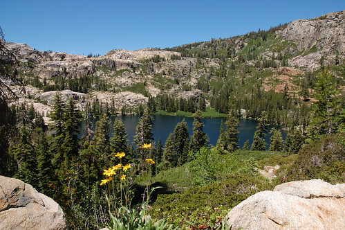
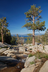
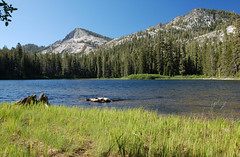
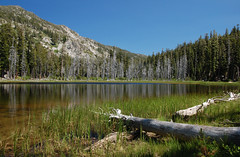
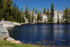
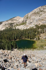
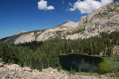
Lake Sylvia, October 2007

For attempt #2, we set out late in July of 2008. I had studied the map and a photograph from that website mentioned earlier, and thought it would be easy enough to find the way. We marched off to Lake Sylvia via the Lyons Creek Trail, and then it was time to climb to "the obvious notch SSE of the lake."

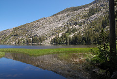
I've got to be honest. Erik and I are enthusiastic hikers, but we don't have much experience, and don't seem to be naturals at this either. We have some problems. Looking from the shore of Lake Sylvia, neither of us could spot a notch that was obvious. In fact, we had to get out the map just to clarify that north of the lake was Mt. Agassiz, and not Pyramid Peak--Pyramid Peak doesn't look like much of a peak or a pyramid from Lake Sylvia (although it does from the east). Additionally, the map made it look like we should just skirt the shore that we arrived at before starting up, which is what we did.

20080726 Lake Sylvia
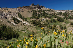
We should have been farther to the right in this photo

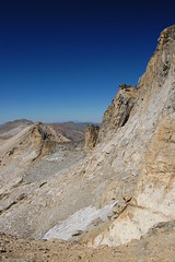
We tried to find the easiest way up, going gradually from west to east, climbing at a slant to what we decided was most likely our notch. But after a lot of work, and having to climb down and back up again on talus and slab to get around impassable objects, we reached a very steep portion with smaller rocks mixed with dirt--not good footing at all. We sent some rocks tumbling, and finally gave up, and went down the talus and slab portion with the largest boulders.

As we got down to the lake, I heard people discussing the way up and saw them pointing, and soon they started up. They headed towards the same notch we had been aiming for, but they started considerably more to the east. Rather than start climbing from the southwest corner of the lake, they started from the middle of the south shore, about where the trees end. We stayed and watched them, and more people who followed, and a man hiking down. They avoided entirely the steep portion with poor footing that had stopped us, and their route looked easier. Three guys who came later, though, climbed right up to where we had been, and made a very laborious ascent up the ridge from there, sending many rocks flying, and exchanging terse words with each other.

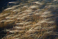
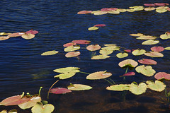
We had worked too much to start the ascent over, so we instead enjoyed Lake Sylvia--it was my third time there, but the first time I really spent time at the lake. And we went off trail following Lyons Creek for a portion on the way back, which took us through some lovely meadows where the creek meanders and has trout swimming in it. The trout are not native to streams and lakes above 6000 feet in the Sierra Nevada, but have been stocked there since the 19th century, and survive in some lakes and streams even in national parks in the Sierra Nevada, which are no longer stocked.

So we once again failed to make it up to Pyramid Peak, but at least we had scouted out the route, and knew how to approach it on our next attempt, which wouldn't be until early September.

20080903 Climbing the Talus
Erik on the talus

One bad thing about starting later in the season is that it means less time before sunset, and we got a late start from Sacramento too. We did much better on this effort, making our way, rather slowly, up the talus to the notch, and continuing up from there. There was no clearly blazed use trail, but the general way seemed obvious enough, and every once in a while we would come across a section of use trail on the steep climb. We got very high up, just below the peak and the final scramble up talus. But we were pressed for time at that point--there was a good chance that if we continued to the peak, we would not make it back to the car before dark. It's not like the peak was going away anytime soon, so there really was no pressing reason to risk it. After resting and checking out the outstanding view of a pond on the slope up above Lake Syliva, we headed back. We made it back to the car just after sunset, while there was still a good bit of light. That was it for climbing Pyramid Peak in 2008.

20080903 Just Below the Summit
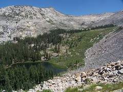
The summit of Pyramid Peak to the right

20080903 Betwee Pyramid Peak & Mt. Agassiz
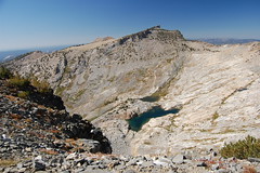
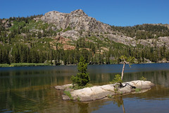
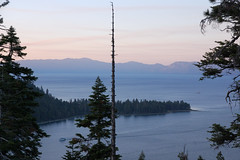
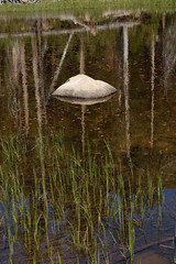
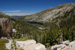
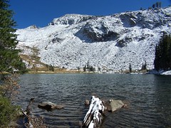
Ponds between Pyramide Peak and Mt. Agassiz

For 2009, I briefly considered a different approach--taking the shorter route (with more climbing) from U.S. 50, which is more popular, or camping at Lake Sylvia so as to get a very early start on the climb. But no, I had to finally do what I had set out from the trailhead three times before intending to do, and not done. No turning back this time, no excuses.

So at the end of July I set off, alone this time, and on a weekday, with the hope that it would be just me and the mountain. I took a mechanical pencil along to jot down the time at various points along the trail so I would have a good estimate of how long my return would be.

8:45 Set out from the trailhead along the familiar Lyons Creek Trail.
9:25 Passed junction with Bloodsucker Lake Trail.
10:37 Reached fork in trail, one way heading to Lyons Lake, my way towards Lake Syliva.
10:47 Reached Lake Syliva
10:52 Started up the talus from the south shore of the lake.

We had successfully completed this portion of the hike the year before, so I hadn't been too concerned about it, until I actually started it. Looking up the huge slope of talus was pretty intimidating, and I started questioning my decision to go on a weekday. There had been campers at the lake, but nobody was around climbing the way I was going. As I started up, someone at the lake started playing the harmonica. It was rather strange, climbing by myself over huge rocks, with just the sound of a distant harmonica and the wind in the trees now and then.

I took my time, and took breaks along the way up, looking down at the lake. I noticed that someone was standing on the north shore apparently watching my progress the whole time.
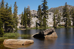
20090730 Lake Sylvia from the Talus
Taking a break

Closer to the top, there is solid mountain on the left and right, with talus in between, and above that dirt with loose rock. The left side next to solid mountain looked best to me, so I went up that way, but farther up there was a distinct use trail on the right side next to the solid mountain. Sometimes I skipped around sketchy looking portions that were definitely heavily traveled, but looked terrible for footing. I reached the notch at 11:37, so it took 45 minutes for me to climb up from the lake.

All accounts I have read of this hike are pretty dismissive of the next portion, saying the peak is obvious, and you just head up. But really, the route you take up the steep slope can make a big difference in how difficult the hike is. There are portions near the start that have ups and downs, rather than just continuing up, which make going more difficult, and there are sections of talus. But it is possible to navigate around them, and take an easier way up. The patches of use trail help.

I had mixed success in finding the easiest route. I would find a patch of use trail and then lose it, and then find it again, sometimes closer to the ridge than I had been traveling, sometimes farther away from it. I began to suspect that there were two distinct use trails, and I kept alternating between them.

I had to stop to rest a couple of times on the way up, and I ate my sandwich, the only food I had brought on the hike. Where I stopped there were lovely views of Lake Sylvia and a pond just below the notch on the other side from Lake Sylvia. Father up, I could see a couple of cabins in a beautiful meadow down to the southwest. I think these are the cabins in Upper Forni mentioned in Robert S. Wood's 1970 guide to the Desolation Wilderness.

1:00 Or a little before, I reached the spot that Erik and I had stopped at last year. I forgot to check my watch until a little later.

Nothing to do from here but face that boulder and talus climb. Again, it appeared intimidating, but also quite beautiful, with the rocks bespeckled with green and pink/peach lichen. There were a few trees out in the middle of the talus, indicating soil in that area, so I thought there might be some easier hiking. I headed towards one on the left, only to end up veering back towards two on the right. Near them was some soil where it was easier going, but it was a short patch. I knew what was down over the ridge to the left--a sheer drop. I thought maybe there was an easier ascent over the ridge to the right, but I figured it might also be a sheer drop that way, and the latter theory proved correct.

I was really panting and my heart racing, but I reminded myself it wasn't just the effort, it was because I was approaching 10,000 feet in elevation and the air was thin. I was finally going to stop and, but having just reached much smaller rocks, I could see the summit was very close. I decided I'd rather rest with a view.

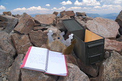
1:23 I reached the summit, 4 hours and 38 minutes after departing from the trailhead. There were several deep enclosures up there, where people have dug up the rocks and put them up as walls, undoubtedly nice for getting out of the wind on some days (not a problem that day). There was a container with the summit register, a cardboard crown for being king of the mountain, and various other bits. According to the register, one other group had been there before me that day, firefighters from Sacramento who came via the more popular route from U.S. 50.

20090730 There is no try.

But what about the view? I don't know any way to capture it in a compelling photograph, but it was stunning. There were too man lakes visible for me to be able to identify them all. Lake Aloha, of course, predominated, but I could also see Lake of the Woods, many small lakes, a fantastic cascade of water running down the granite between, I believe, Desolation Lake and Ropi Lake. Even portions of the Echo Lakes, Fallen Leaf Lake, and the south end of Lake Tahoe (and a couple of casinos) were visible. Even from that high up, I couldn't fit all of Lake Aloha in view with a wide-angle lens.
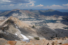
20090730 Partial View from Pyramid Peak.
Part of Lake Aloha

I stayed for half an hour at the summit, and then started the long, but relatively uneventful, trek back. As I started down from the notch to Lake Sylvia, I fell on my butt, and got a small cut on my hand. I took it as a reminder to be cautious on that portion. I remember working my way down it pretty quickly last year, but I think I was definitely slower this year. I made it to the lake by 3:25, which meant I had plenty of time. The only reason I had to hurry back was hunger. I reached my car at 5:23, and headed off for dinner in Placerville.

Monday, July 27, 2009

Tahoe National Forest: Warren Lake Trail

20090725 Warren Lake
Tantalizingly Close to Warren Lake

My friend Erik and I decided to go hiking on Saturday. He suggested we take the Rockbound Pass Trail in the Desolation Wilderness, but I hiked that trail twice last summer, and was interested in something new. I checked _California Hiking_ and found one trail that was close enough to drive to for a day hike, was a challenge in terms of length and difficulty (which I was looking for), and promised to be a beautiful hike (the book gave it a 10 for scenic value): Warren Lake Trail.

I suggested it to Erik and sent him a link to a photo of the lake, thinking he would just trust me about it being suitable. But instead he looked up information online about the hike and found it was described as "very difficult," and recommended only as a 2-day backpacking trip.

Of course, that hike on Rockbound Pass Trail to the lakes just past the pass is also described as a 2-day backpacking trip, as is the one we had made a couple of weeks earlier to Rubicon Lake. That hike was 16.2 miles, whereas this one was listed in my book and online as 14 miles (turns out it is 15). None of the descriptions were too exact, but I figured from them that it would involve about 3,000 feet of climbing, 1,500 of that on a short and very difficult stretch. Frankly, it sounded perfect to me--something just a little more difficult than what we had ever attempted before. I talked Erik into it.

Let me tell you, if you are interested in doing a lot of hiking in El Dorado National Forest and Tahoe National Forest, you need to buy or borrow a copy of The Tahoe Sierra by Jeffrey P. Schaffer. The geological information is fascinating, but more importantly it gives very accurate and full descriptions of the hikes and accurate measures of distance and elevation gain on the hikes and the various ways to add variety to those hikes (with spur trails, or taking different ways back). I couldn't find my copy of it right off, and wasn't really concerned about the hike, so I didn't worry about it. Only afterwards did I find it because I had to quantify just what we had been through: 15 miles, and more than 4,000 feet of cumulative elevation gain (that is, counting all the climbing on ups and downs, not the net elevation difference from the trailhead to the goal of the hike). And most of the climbing and descending was steep.

We had a bit of a delay getting started. The Castle Peak/Boreal Ridge exit from eastbound I-80 was closed for construction, so we had to take the Donner Lake exit, get on westbound I-80, and get back to our exit.

Then I just turned north up a short distance from there to what looked like a trailhead, knowing that the lake was north of the freeway. But after walking up to a map on a fire road, I realized the trailhead was on the south side of the freeway, and I quickly checked the book and read a little more, as I should have done the night before. We drove over there to the parking area for the Pacific Crest Trailhead.

On this really easy early portion of trail that caters to travelers just stopping off the road for a few minutes to stroll in the high Sierra Nevada, we took a wrong turn where a portion of the sign with the information we needed was broken off. I'm going to say it was because of bears rubbing up against it to scratch their itches.

So we ended up at a rest stop for eastbound I-80, looking totally out of place in our hiking gear. We were looking for a tunnel under the freeway, but there wasn't one there. Another map indicated where we went wrong, and we headed back to the last junction and took the right path.

It was a short delay, and it was easy hiking, but not a good start for a hike on which Erik was concerned about us getting back before dark. I didn't really think it would be an issue. He asked me if I had my headlamp with me, and I told him "Possibly." I like to have it in my backpack in case it's needed, but I hadn't checked if it was there, and I couldn't really remember if I had it in there on my last couple of hikes. (Much later I checked, and I did have it.)

So we hiked through the tunnel underneath I-80, lined with corrugated tin. We crossed a small trickle of water going up every so slightly and came to a junction. I think the fork we did not take, from the maps we had seen, goes back to the rest stop on westbound I-80. If you can park there (I suspect it might not be allowed, and might not be as safe for belongings in your car), it would shorten the hike a tad.

We proceeded through forest to an open area filled with false hellebore. I really love the leaves of this plant, but experience tells me to rush through areas where it is still green, as there are always lots of mosquitoes around. We continued climbing at a very easy pace on dirt trail--so much easier on the feet than stone--to a junction signed for Summit Lake to the right and Warren Lake to the left.

Heading off towards Warren Lake, it didn't take long for the trail to start climbing more steeply. It was steep enough that I was surprised. From the hike descriptions I had read, I was imagining that it was a pretty gradual 1,500-foot climb for 6 miles, then a steep and difficult drop for 1 mile. But here we were climbing rather steeply early on.

We emerged into an open area covered with mule ears and with fabulous views of the mountains to the south and of the snow sheds along the first railroad passage through the Sierra Nevada. Below the trail to the right was a muddy area where a snow melt-fed pond must have recently been, and up above to the left was a hollow in which there was some still unmelted snow.

Shortly after this is a climb to "the saddle." Erik had mentioned this point from what he had read online about the hike, and this was definitely it. (A saddle is just the low point in the dip between two peaks.) There was an unsigned junction here, with a trail climbing up to the peak. We passed it by, but apparently it leads a short ways to a lovely overlook of Frog Lake.

From here we started down, which surprised us. We were expecting to basically be climbing up until the last mile, when we would make a sharp decent. But no, that would have been far too easy. This is what makes this hike difficult--the continual alternation between steep climb and steep descent.

This descent wasn't so bad at first, and when the trail came to a turn there was a sign indicating 4 miles to Warren Lake. The marker reassured us that we had made the right choice at the unmarked junction above.

We descended on gradual slope through forest and past an open area with a large snow bank to the edge of a open valley, and then started steeply down its face.

It was tough going just to keep our footing on this steep descent, but what a view! Volcanic Basin Peak shot up in front of us to the west with a slope down into the valley to a large section of exposed granite. And there were wildflowers of all sorts on either side of us.

20090725_13373
What a View!

Getting lower, we began crossing numerous small streams from the snow melt. Then we started another steep ascent, this time across a ridge of fine dust and rock from a lava flow, with unstable footing.

Characteristic of these ancient lava flows are mudflow blocks. They look to me like discarded chunks of concrete, and I was confused by them when I first encountered them, but the trusty Tahoe Sierra book explained them to me. They are like concrete: concrete is aggregate, like rocks, bound together with cement. Mudflow blocks are aggregate of loose rocks bound together by the mixture of superheated mud rushing ahead of the lava flow.

Once up that tough climb, we went down and up and down and up I don't know how many times. Down each time to cross the stream of run-off, then up to the next ridge. I was grumbling a lot to myself at this point about how there must be a much easier way to reach Warren Lake.

Finally we hit the easiest portion of trail since the junction with the trail to Summit Lake. It had beautiful views of a green valley far below to the east, as well as of the dramatic terrain we had just passed.

We came to a signed junction, to the left for Devil's Oven Lake, to the right for Warren Lake, with a distance of 1 1/4 miles. I was keeping track of the time, and when we would need to turn back, and it had been getting questionable. From my calculations, we still could make it to the lake and back with enough margin for error in my estimates that we would be safely back to the car before dark. But we certainly weren't going to have much time to spend at the lake.

The first portion after the junction is quite easy and level. There is a momentary drop after that, and then some easy descent. But then we hit a vicious descent. After struggling through it trying to keep my balance, I reached a flat area and thought, "Am I down to the lake already? That wasn't too hard." But that portion is maybe 1/3 of the way down.

When we began descending again at first it was a little easier, but then we hit portions that were just as difficult as before. As Erik said later, it didn't really matter if you followed the trail or not, as the trail wasn't any easier than just picking your way down the slope. The last 20 feet or so was the worst. It was as though the person who had chosen the route for the trail just gave up at that point.

There were four tents pitched at the flat area at the end of the trail by the lake, and a fire pit that was well built up. But the lake was not accessible directly ahead--too many woody shrubs, or dwarf trees. I started off to the right, where I could see an inviting peninsula, but it soon appeared there would be some difficulty scrambling to get there, and I wasn't up to it at that point. So I walked through the tents to another camping area that was unoccupied and rested for a while, waiting for Erik to catch up.

But as soon as I felt recovered enough, I couldn't resist the impulse to go exploring to the west. We weren't going to have much time before we started to head back, and I wanted to get some photos. There appeared to be some nice granite slabs to the west side of the lake, and with the light at the time, that is where I would get my best photographs.

I followed a use trail around, and indeed, the west shore of the lake is the place to be. There are nicer camp sites, there, and easy access to the water. In fact, that is where all the guys who were camping at the end of trail were hanging out at the time.

20090725 Warren Lake
The Goal of the Hike

Not surprisingly, it took me longer to get over there and take my photos than I had anticipated. By the time I got back, I was thinking it was time to start heading up again. But I encountered an exhausted Erik who had tired himself on that scramble I had passed up to the east, thinking that is the way I would have gone.

So we hung out until he was ready to go on. I drank as much water as I comfortably could, so I wouldn't have that weight in my backpack on the way up, and tucked away my camera, thinking I wouldn't bother to get it out again.

That was a long climb. We stopped to rest many times. I congratulated Erik when we finished it, as we had finished what was technically the toughest part of the hike. But it wouldn't seem like the most difficult part to me, given how exhausted I was when I tackled the later portions.

The worst of these was the steep descent (this time) down the dusty volcanic ridge and then very long and steep climb up in front of Basin Peak. When we finally reached the end of that stretch, I went over and sat back on a snow bank to cool off. Later I dug through the top layer of snow to get to some clean snow to put into my canteen for extra water on the way back.

From there we had our last climb back to the saddle. It was pretty much all downhill from there, but our feet were sore, and my legs were aching. The beginning portion of the hike, the mostly flat area around I-80, had seemed so quick in the morning, but it really dragged on for us coming back. Erik said that he thought we were as good as at the car when we passed through the tunnel under the freeway, and was shocked to soon see a sign indicating we had 3/4 mile to go.

About 10 hours after we had left it, we made it back to the car. We made it back with plenty of time before sunset, as I had been sure we would when originally choosing to take this hike. But while I had been the one who pushed for it against Erik's resistance, it turns out I was the one who regretted it. The next day Erik reported that he was well recovered, and climbed 4 flights of stairs at the library. I would have taken the elevator, given how sore I was, and still am 2 days later.

Monday, July 13, 2009

Lake Tahoe Basin: Meeks Bay to Rubicon Lake

With my friend Erik's wife out of town for a while, we decided to try and get the most hiking out of the extra time by going camping. That way we could hit the trail first thing in the morning rather than wasting time driving from Sacramento. And we chose a trailhead that is a good long drive away from the state capitol.

Our big hike was planned for the second day, but we were going to do some hiking the first day as well. On the way up to South Lake Tahoe, we diverted over off to do an off-trail, or at least off of any official trail, hike to an area that locals prefer to keep a secret, and I now know why. So I won't say any more about that.

Next we got our campsite at Bayview Campground. The place was pretty busy with day hikers using the parking for the Bayview Trail and overflow parking from Inspiration Point above Emerald Bay across the road, but the campground itself was nearly empty. It's only $15 a night, less than other campgrounds around Lake Tahoe, mainly because it has no plumbing.

We took advantage of the site to hike up to Granite Lake on the Bayview Trail, a lake I had skipped over on my two much longer hikes up the Bayview Trail to the Velma Lakes. I took a quick swim.

20090708 Snow Plant
Snow Plant on Bayview Trail

Then we headed down and over to Cascade Falls. We were there a bit late in the day--the big waterfall down to Cascade Lake was in shadow, but it's a difficult subject to photograph under optimal conditions anyhow. The creek spreads out all over the granite with lots of mini falls in the area above, and we spent a good bit of time scrambling on rocks and exploring that.

20090708 Above Cascade Falls
Above Cascade Falls

When we got back to the campground, there was a bear making an inspection of all the campsites for food, and a bunch of damn-fool campers following after it with their cameras. I took out my camera too, but I didn't take a single step in its direction. Of course, I didn't do what I should have done either--scare it off with loud noise. It is much better for bears if they remain afraid of humans rather than getting comfortable around them.

20090708 Camp Visitor
Black Bear

We watched the sunset from Inspiration Point, but it was not dramatic as I had hoped it would be. Then it was back to the camp site to build a fire.

20090708 Emerald Bay
Inspiration Point

In the morning we watched the bear make its rounds again before we headed off to the Meeks Bay trailhead, right across the highway from Meeks Bay Campground. Most of our hike repeated a hike I took in August of 2007 from Meeks Bay to Stony Ridge Lake, so I'll be brief in my description of that part of the hike. Please see the other blog entry for a more detailed description.

The hike starts on a closed dirt road--nice, soft dirt. It's flat, and we were moving as fast as we could to keep warm, as it was cold in the morning and I didn't want to bring my jacket when I wouldn't need it for most of the day. There were many lovely wildflowers there, and many locals just like to walk this first section with their dogs.

At about 1.3 miles there was a signed junction with a trail leading uphill off the right edge of the trail and road continuing on while turning a bit to the left. We started climbing, fairly steeply, on the narrow trail. Once up to where it joins the creek, the trail climbs at a moderate pace, and the area around us was lush with ferns, wildflowers, and mosquitoes. Eventually the trail drops down to the south and crosses the creek over a large wooden bridge. On the other side the trail climbs alternately west and south before curving around on a slope above the creek dropping rapidly off to the right.

20090709 Alpine Lily
Alpine Lily

All of the lakes on this hike are connected by creeks, so on the way out and up, we were always going to where the water was coming from, only we were taking the more gentle grade, while the water was taking the more direct path. As you approach each lake, you will find that you and the creek get closer and closer together in elevation.

20090709 Unidentified Fungus
Fungus Just Before the Junction

Just past a signed junction with General Creek Trail we found Lake Genevieve, right where I left it two years ago. It's a nice lake framed by mountains on the south and west sides and with open areas to hang out on the east side. But the next lake is framed a little more dramatically, and is larger.

20090709 Lake Genevieve
Lake Genevieve

So we made the short hike up the moderately graded trail to Crag Lake, which has two nice little islands in the south end. There are lots of nice areas to hang out along the east shore, although they are divided by a rocky outcropping that we hiked around.

20090709 Crag Lake
In Crag Lake

From there we rock-hopped across a creek and started up a bit more steeply. At one point the trail turns sharply left and there is a clear trail heading down to the right, and we could just see some water in a lake below. There is no signed junction here, but that is Hidden Lake below. I went there last year, but it was very steep, and I didn't want to waste the energy this year, as we had a farther destination in mind.

20090709 Shadow Lake
Grassy Shadow Lake

So we headed off on the trail to Shadow Lake. By the time you see Shadow Lake on the left, most of it is already behind you. As a result, it looks smaller than it actually is. I remember thinking in 2007 that it was close to becoming a meadow. Certainly the south end of it looks that way, but on our return we went off trail to the south end of it, and saw that there is a good bit of water.

20090709 Shadow Lake
Shadow Lake

I promised Erik that it was just a short ways up ahead to Stony Ridge Lake, but it was farther than I was remembering. When we got to that lake, we hiked a little ways along its long shore before stopping to rest and to eat. I thought it would be a good idea to rest because we had one big climb left to Rubicon Lake, and then that would be it for climbing for the day. The beauty of this trail is that there are very few ups and downs. Instead, it just consistently climbs on the way out, so the net elevation gain is pretty close to the cumulative amount of climbing that you do, and it's almost all downhill on the way back.

20090709 Stony Ridge Lake
Stony Ridge Lake

After eating we continued on along the lengthy west shore of Stony Ridge Lake and started to encounter what I found to be the most interesting scenery on the whole hike. Off to the left we saw a large pool of water with several grassy circles--nearly perfect circles--surrounded by grassy swamp, except that a large protrusion of bulbous, rounded granite stuck out into it. On higher ground where the trail runs there was lush vegetation intermixed with large granite boulders, and towering to the southeast was an imposing solid granite wall.

20090709 Stony Ridge Lake
Stony Ridge Lake from Above

After running close to this cliff, the trail started away from it, and almost over to the creek cascading down a steep, fractured cliff. Then we immediately headed back the other way on a switch back. As we climbed hire we were afforded lovely views of the great length of Stony Ridge Lake. Finally the trail curled up to the left in a passage between granite cliffs and up to small and lovely Rubicon Lake.

20090709 Rubicon Lake
Rubicon Lake

I searched around for a nice granite shelf to hang out on for a while. After talking about it a while I couldn't resist the impulse to take a quick swim. It was too cold to stay in the water for long, but I just wanted to be able to say I swam in Rubicon Lake, 8.1 miles in distance and 2,080 feet in elevation away from the trailhead. While drying out on the granite I spotted something swimming close to the opposite shore, and Erik identified it as a beaver.

20090709 Rubicon Lake
South End of Rubicon Lake

We explored around the lake a bit--there were many lily pads on the east side, to which we did not make it, and a few on the south edge where we were taking photographs.

20090709 Lily Pads

Initially I wanted to wait longer so I could photograph Rubicon Lake and Stony Ridge Lake in the afternoon light, instead of the harsh overhead light of the middle of the day, but I realized we had a long ways to go, so we started back.

At first, the return trip seemed very easy--it was all downhill and not too steep either. But the sheer length eventually began to take its toll. All the way down past Lake Genevieve and across the wooden bridge, when we could finally see Lake Tahoe I was surprised by how far away and how far below it appeared. And the last part of the hike was just soldiering on, putting one foot in front of the other.

By the time we both made it back to the car it was a full 10 hours after we had set out--certainly our longest hike, and a very satisfying day.