When I head down to my grandmother's, she often indulges me and we head off to visit restaurants I have read about. We've been doing this much longer than I have been taking photographs of restaurants and food, or researching the restaurants, so my memory is spotty on some of them. But I plan to continually revise this blog entry as I visit more places, or revisit ones I haven't been to in some time.
Here, then, are some classic eateries I have visited in the East Bay, particularly in Contra Costa County.
Ole's Waffle Shop
1507 Park Street
Alameda
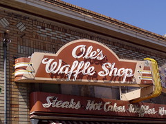
When I posted the first version of this blog entry, I received an enthusiastic response from one of my long-time Flickr contacts, with one caveat--she couldn't believe that I didn't include Ole's Waffle Shop in Alameda. I had photographed the sign, but never eaten there. Now that omission has been redressed.
Ole's opened in 1927, although not originally at its present location, according to the San Francisco Chronicle, and the waffles served today are still made according to Ole Swanson's recipe. It moved to Park Street in the 1930s. After Ole's death, the restaurant languished until Bob Adams bought it in 1972 with a down payment of $100 (all this information from the Chronicle, 2/5/1999).
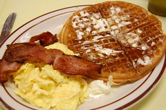
Today, there is still a counter, thankfully, as there was a line outside on the Sunday morning I visited. There are photos on the wall showing the history of the restaurant. About the only design element that looks vintage are the orange and yellowish wall panels, which probably date from the 1960s.
Bip's Broiler
3211 Encinal Ave.
Alameda, CA
I read about this place in the East Bay Express, and headed off with my girlfriend at the time to find it. It's well worth seeking out. On Encinal next to the Encinal Shopping Center, it is wealth off of Park Street with its antique stores and crowds of pedestrians. While people wait in line for breakfast on the weekend at Ole's on Park Street, it's easy to find a table at Bip's Broiler, despite the fact that it is very small, and despite the fact that the food is both better and cheaper than at Ole's. The hashbrowns are particularly outstanding.
It hasn't been Bip's Broiler long, but the place is vintage, as it was the Burger Orchard for at least 25 years. The stools at the small horseshoe counter look to be at least that old.
Fondue Fred
2556 Telegraph Avenue
Berkeley
What could be more delicious or sociable than sharing fondue? It has always been a treat for special occasions in my family. This specialty fondue restaurant, tucked inside the Village Mall, has been around since 1958. It's a dark and cozy restaurant with dark wood tables. Fondue is the one dish I specialize in making at home, and I've eaten it at restaurants in Lucerne, Paris, and Quebec, so it's hard to impress me with fondue, and, well, I wasn't impressed. But still, mediocre fondue is better than no fondue at all, and the taste, price, and ambiance were all better than at The Melting Pot. I'd like to go back, only hopefully I won't have to drive next time, as parking is a problem.

Spenger's Fish Grotto
1919 4th Street
Berkeley
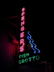
In 1890, Bavarian fisherman Johan Spenger opened this Berkeley institution. Johan's grandson Buddy Spenger was the last of the family to run the restaurant. It was Buddy who made it into so much more than a place to eat fresh fish. He used the salvaged remains of two shipwrecks to cover the walls and floors, installed 500 antique guns, and acquired a 34-carat diamond ring formerly owned by a Hawaiian queen to display in one of the bars.
In the late 1990s, Buddy suffered a stroke, and retired. None of his progeny was interested in carrying on the family legacy, so the restaurant was set to close. But an executive from the McCormick & Schmick chain of high-end seafood restaurants who had grown up in Berkeley urged the company to purchase the restaurant. On her urging, Doug Schmick flew out to dine there, and subsequently, the chain bought the restaurant.

And that's how I came to hear of the place. I was given a $20 gift certificate to McCormick & Schmick restaurants by Alaska Airlines for having flown with them on Christmas day. Spenger's Fish Grotto was the only restaurant listed on the back anywhere near me (although they recently opened a restaurant in the Elks Building in downtown Sacramento). So my grandmother and I had dinner there.
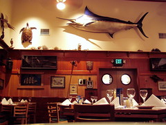
It is an enormous, and magnificent place to behold. I highly approve of Buddy's decorating. They have many dining rooms, and more than one bar. As for the food . . . the seafood is very fresh. You can't go wrong with simply prepared fresh seafood. If you are looking for artistry and delicious sauces and the like, head off to some chef-driven restaurant, rather than a corporate notion of high class dining. For that kind of money, you can definitely eat something more interesting and delicious. I enjoyed my fish (though not so much the sauce with it), but the clam chowder was pretty lame--I would think a high-end seafood chain would have had to master that before expanding.
But even if the food there is not to your liking, it's well worth going for a visit--at least to have a couple of drinks in the bar and see the 34-carat diamond.
Hotel Mac Restaurant & Bar
50 Washington Avenue
Point Richmond
This is one of those places I have vague memories, and no pictures, of. I dined there with a host of relatives when I first moved to Northern California. I wasn't fully settled in my apartment yet, and I certainly didn't know my way around that well. I just remember driving through a lot of ugly neighborhoods, and then getting to a lovely old town center.
The restaurant is in a historic hotel, built in 1911, and on the National Register of Historic Places. We ate in a private dining room, which was also being used as a wine cellar. The waiter couldn't remember one of the desserts, and hemmed and hawed about it, before it finally came to him: tiramisu. Other than that, most of what I remember is our conversation and the clothing I wore--I have no recollection of what I ate.
Casa Orinda
20 Bryant Way
Orinda
When I read about Casa Orinda, I was excited. Jack and Tommy Snow, from Montana (where I am from), opened a bar that became this Orinda institution in 1932. It was a den of vice in the early going, with gambling and prostitutes and bootleg liquor, but a deal with the sheriff insured they were always clean when there was a raid.
I guess I figured a place with that kind of legacy would be pretty casual, because I was terribly under dressed when my grandmother and I visited. I was, as is often the case when visiting these old restaurants, surprised by the high prices, but they corresponded to the elegant atmosphere and valet parking . . . and the fact that it was Orinda.
The place is an upscale western restaurant, dimly lit with large western paintings on the wall. The menu touted their famous fried chicken, which has been served there since the beginning, so that's what I had. I'm sure I enjoyed it, although I don't recall anything unique about it.
Petar's
32 Lafayette Circle
Lafayette
This classic steak and seafood house with a neo-Tudor interior opened in 1959. It was a favorite of my grandparents, and when my cousin came out to visit a few years ago, this is the place my grandmother and I chose to take her. Some time I've got to check out the piano lounge.
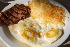
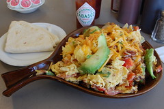
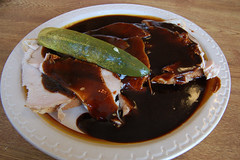
The Squirrel's Coffee Shop
998 Moraga Road
Lafayette
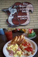
Finding an affordable vintage diner in upscale Lafayette was certainly a delightful surprise for me. There's nothing fancy about this place. It has a short menu of breakfast and lunch items, and an old counter with stools. This is the sort of place I would make a habit out of eating at, if it were at all handy to me. I believe the breakfast featured in the photo is fluffy eggs with ham.
Nantucket Restaurant
501 Port Street
Crockett
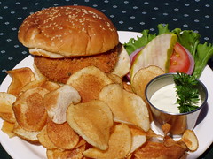
Crab Cake Sandwich
My grandparents took my mother and me here sometime in the 1980s, and when I moved in 1996 it was my choice for my first birthday dinner as a resident of Northern California. You have to drive down below Interstate 80 as it approaches the bridges to cross from Crockett to Valejo, and then park in a dirt and gravel lot, but the reward is waterfront dining, with several outdoor tables.

Al Fresco Dining
The restaurant has operated under different ownership and slightly differing names over the years, but still maintains a venerable character.
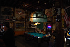
Warehouse Cafe
5 Canyon Lake Drive
Port Costa
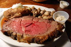
One-Pound Prime Rib
Tucked in a narrow valley up against the bay and railroad tracks between Crockett and Martinez, Port Costa is only accessible via narrow and winding roads. In this small town is a lovely old schoolhouse, church, hotel, and a big old warehouse building. In this building is a funky bar that serves 460 different types of beer, and is decorated with salvaged historic pieces and lots of kitschy decorations. I'm not sure what classification the enormous stuffed polar bear falls under.
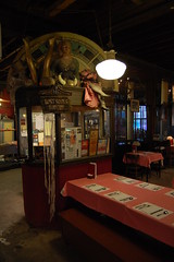
There's a dining area there, and on Friday and Saturday nights it is open for business as the Warehouse Cafe. It's a very limited menu, with a minimum charge of $12.95 for the all-you-can-eat soup and salad bar, a baked potato, and mushrooms. I had the $20.95 1-lb prime rib, cooked medium rare, which came with all of the above.
I've only had prime rib a handful of time in my life, but I would have been ordering it a lot more often if I had ever had prime rib like they serve at the Warehouse Cafe before. It was fabulous--so tender and juicy, and with a delicious and crunchy coating around the outside. I had half of it for dinner, and half for breakfast the next day. Lobster is also quite popular there, and they have a tank in the dining room with the live lobsters on display.
Pinky's Pizza Parlor
1379 South California Boulevard
Walnut Creek
Pinky's is an old hole-in-the-wall pizza place that opened in 1962, and is still cranking out the pies.
The Original Hick'ry Pit
1259 South Main Street
Walnut Creek
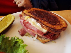
Grandma's Reuben
This restaurant opened as Emil Villa's Hick'ry Pit in 1958. They are still serving up pie and smoked meats to large crowds--we had to wait for a table. Being that it's in Walnut Creek, it is a bit higher priced that what you would find for a similar restaurant in Sacramento, but it has a lot more character than most of Walnut Creek.
Skipolini's Pizza
2001 Salvio Street
Concord
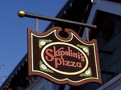
This is one of the youngest restaurants on this list, and I haven't even visited their oldest location, the one listed above in Concord, which opened in 1974. My grandmother suggested Skipolini's when I told her what kind of restaurant I was looking for, as it used to be a favorite of my uncle's. I found they had a closer location in Walnut Creek.
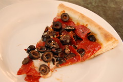
The Walnut Creek location has a beautiful mural of Mt. Diablo on the walls, and sawdust acovering the floors. There's a lovely closed-in, outdoor dining area as well. The veggie pizza we had the first time we were there didn't impress me, but the fully-loaded pepperoni and black olive pizza we had the second time was fully satisfying.
Sugar Plum Coffee Shop
1815 Colfax Street
Concord
Sugar Plum Skillet
According to the Contra Costa Times, this vintage diner opened in 1959. It's a cozy little place, lined with historic photos of Concord, from when it was a much more interesting place. I'm sure they do fine breakfast standards there, but I made the mistake of ordering huevos rancheros. Really, I should have known better than to order Mexican food at any place other than a Mexican restaurant when in California, where there are so many great Mexican restaurants.
Barney's Hickory Pit
3446 Clayton Road
Concord
Inconspicuously tucked away in a strip mall--what originally was probably touted as a "modern drive-in shopping center"--across the street from a Goodwill in a 1940s era building lies this unexpected gem. Barney's interior looks straight out of 1957, when the place opened. The exterior has changed, though, as a piece in the window put together for their 50th anniversary shows that they used to have a great neon sign out front.
The barbecue sauce was . . . well, certainly different than any barbecue sauce I've had before. My open-faced turkey sandwich was served on soft white bread, and my grandmother found out that they don't serve ranch dressing on their iceberg lettuce salad--all very 1957.
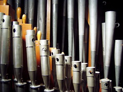
Bella Roma Pizza
101 Main Street
formerly 4040 Alhambra Avenue
Martinez
I haven't been to the new location on Main Street in Martinez, but have visited the Alhambra location several times. This place was a favorite with my grandparents when my uncle and aunt were young. It was a favorite with kids, and with me too, for the Wurlitzer organ, driving many instruments and a bubble machines, and the miniature railroad that ran above everyone's heads. I presume these features are all at the new location to, but haven't had the chance to check yet.

JT La Beau's
436 Ferry Street
Martinez
I don't recall much about our visit to this restaurant in downtown Martinez, except that they served Louisiana style cuisine, and had an energy surcharge, as we were there during the California energy crisis. I'll have to try and make it back soon so I can make a fuller report.
Wink's Restaurant
3835 Alhambra Avenue
Martinez
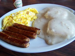
Biscuits and Gravy
This old diner has been around since at least 1961, and photos inside show that it was an old drive-in restaurant before that.
Riverview Lodge
I Street Wharf
Antioch
On a fishing pier on the edge of historic downtown Antioch, this time warp of a restaurant was built in 1948. It burnt down and was rebuilt in 1961, but apparently they tried to recreate the look of the original, as the old wood floors, ceiling, and paneling all look more 1940s than 1960s.
The menu hasn't changed much over the years it seems--you can still get pan-fried frog legs. If you go, you are best off getting one of the most expensive dishes, like cioppino or lobster, which are fairly priced in comparison to other restaurants. The least expensive dishes, like a ground beef, onion, and pepper omelet for $15, are grossly overpriced.
Mac's Old House
3100 East 18th Street
Antioch

While it's last on my list, Mac's Old House is probably my favorite of all these restaurants. According to the Contra Costa Times, Floyd "Mac" McKinney opened it as a bar in his own home in the mid 1950s. They have a beautiful vintage neon sign, a nice and cozy dining area, and quality food. Best of all, all of the food and drinks are inexpensive. So why have I only been there once? It's the location. But it is worth making a special trip for, even at today's high gas prices. I'm sure I'll be back sometime in the next few months.