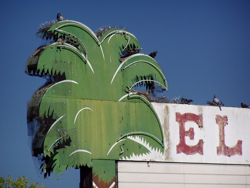
R.I.P. El Rancho Neon
[If you're interested in Highway 40 history in Sacramento, see also my blog entries on Del Paso Boulevard and on Auburn Boulevard.]
While most Americans on roadtrips today are content to speed along controlled-access freeways sealed inside climate-controlled cars and SUVs, only pulling off for the safe and familiar comforts of chain restaurants and gas stations, they are also nostalgic for a bygone era when the traffic on the highway slowed to go through the heart of business districts of both small towns and large cities, and drivers could impulsively pull over to unique roadside diners, motels, service stations, and tourist traps.
While U.S. Route 66 from Chicago to L.A. (omitting the eastern seaboard, the most populous area in the country) has become a focal point for this nostalgia, Sacramento has been home to old highways of arguably greater importance and interest, U.S. Routes 40 and 50. U.S. Route 50's distinction is that it is the only surviving transcontinental highway that is not all Interstate freeway. U.S. 40, now supplanted by Interstate 80 in the West, ran from Atlantic City to San Francisco, and in California is notable for the fact that it mostly followed the route of the old Lincoln Highway, the first transcontinental highway. (U.S. 50 also followed, and in some portions still follows, part of the Lincoln Highway route, the "Pioneer Branch" from Sacramento through Folsom, Placerville, and South Lake Tahoe before rejoining the northern route.)
One of the quickly disappearing local legacies of the pre-freeway routing of both historic highways is the motel row in West Sacramento. This was the major approach to Sacramento from the Bay Area on U.S. 40 for many years, and was part of the original routing of 50, when it originated in West Sacramento, as it does today. (In intervening years, 50 was routed down Stockton Blvd. and then Cherokee Lane through Lodi and into Stockton before heading over to Oakland via the Altamont Pass.) In the then unincorporated area of Yolo County, motels, restaurants, and a drive-in movie theater lured tourists off the road with boldy designed buildings and bright neon lights before they reached Tower Bridge, constructed in 1935, to enter the city proper. The main artery carrying traffic across the Sacramento River now, the Pioneer Bridge, was not opened until 1966.
When the freeway bypassed West Sacramento in 1954, the inevitable decline began. The El Rancho Hotel had once accommodated stars and high-ranking politicians, but when the Cleveland Cavaliers were booked there in 1985, several players refused to stay and paid for their own rooms on the other side of the river. The El Rancho Drive-In Theater became the El Rancho Mobile Park. Being in an unincorporated area without a local police force, the old motel strip became a place to escape strict law enforcement and harassment in the city, making it a popular gay cruising ground, but also an area blighted by prostitution, drug dealing, and fights. Adapting to the times, some of the motels became adult-oriented, like the Experience Motel, which became the Adult Experience.
In that area that now lies within the city of West Sacramento (incorporated only in 1987), there are still a few interesting remnants of the Route 40 heydays, including many surprisingly well-maintained motels, although they are fast disappearing. I started taking an interest in roadside relics in 2000 and photographed many with my old APS camera. Later I got a digital camera and with extensive practice improved my crude skills, and I went back to get better photos of the area, but some I would find were no longer there. And they keep vanishing on me.
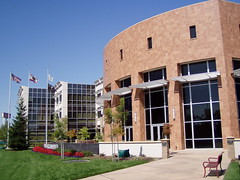
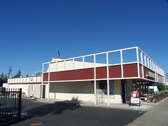
West Sacramento City Hall
Newly incorporated West Sacramento worked to turn around the area's image in the typically American fashion: by destroying the past. The Capitol Inn where Clark Gable once stayed was razed, rather than rehabilitated or reinvented, and became the site of West Sacramento's City Hall. In 1993, only 6 years after incorporation, West Sacramento instituted a comprehensive sign ordinance, strictly limiting the size of free-standing signs. Businesses were given a generous 15-year period in which to bring their signage into compliance with the ordinance, but no exceptions were allowed for. When I first started taking pictures of the signs along this route, I thought all the small, plastic, back-lit signs were there because the motels had changed names when they changed ownership over the years, but my research shows that most of them have been under the same name for 50 years. Those with plastic signs were ones to quickly adhere to the new city ordinance. While the city of Sacramento has sought to protect its identity by protecting its historic signage, like the Joe Marty's sign, the city of West Sacramento is mandating the removal of this important part of its history by May 1, 2008.
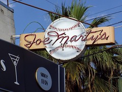
Sacramento's Historic Joe Marty's Sign
Meanwhile, the proximity of West Sacramento to downtown is finally attracting the interest of major developers after the development of Raley Field, the Ziggurat Building, and the associated waterfront park area. Big changes are in store for the city in the near future, but for the moment let's look to the past.
Much of that past is nothing more than tantalizing hints I find in the library, like the names of the Pink Cucumber, or the Hawaiian Hut, old restaurants, or the old motel post cards in the Sacramento Room of the Sacramento Central Library. But I did get to see, and photograph, some of the remaining vestiges of this rich history, and have seen others' photos. Here's a review from west to east:
Ortega's West
4205 West Capitol
In the 1960s, this was the Road House. All that remains from those days, at least outside, are the two arrows indicating where to turn off the road.
Walnut Trailer Villa
2355 West Capitol
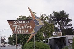
The sign must have disappeared not longer after I photographed it, as I was never able to find it again. Here's a better photograph of it.
Red's Drive-In
2328 West Capitol
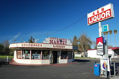
At least since 1961, this has been a liquor store: Henri's Drive-In Liquors, then Springer Bottle Shop, and currently A&B Liquors. But its shape betrays its origin as a drive-in restaurant, and the old city directory confirms this, indicating that in 1957 it was Red's Drive-In. When photographing it recently, a man bicycled by and told me that it used to have a giant top hat on top.
Yolo Club
2216 West Capitol
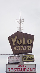
The Yolo Club probably opened in the 1930s. The vintage sign remained until at least 2000, although a Sacramento Bee restaurant review in 1986 of The Western Rib House at the Yolo Club mentions "the site of the old Yolo Club." Now it is operated as Puerto Azul, and the sign has been altered. Here's an advertisement for the Yolo Club from 1978:
"Mention the word 'barbecue' and Yolo Club immediately pops into mind. Long famous for its barbecued pork spare ribs and chicken, the specially-blended, tangy Yolo barbecue sauce is the same recipe developed by the original owners more than 40 years ago. Or try the special Yolo steak, hand cut right on the premises from the finest of choice meats. Yolo Club has a real western atmosphere, with a completely circular bar right in the middle of the dining room! Take the entire family!"
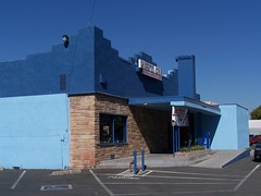
Puerto Azul
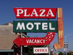
Plaza Motel
2007 West Capitol
In the last couple of years all of the neon tubing has been broken off of this large sign, and both arrows are now gone.
El Rancho Drive-In Theater
2000 West Capitol
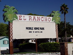
The El Rancho Mobile Park was once the El Rancho Drive-In Theater, which seems more fitting for the glorious sign that once welcomed people to its entrance. A year or two ago I had a call from the owner, from Sonoma. She inquired if I was "Tom Spaulding the photographer," to which I hesitantly answered "yes" (I take a lot of photos, but have never made any money from it). She was looking for a photo of the old sign lit at night, but I was never fortunate enough to see it that way. The sign was taken down early in the summer of 2007.
Part of the El Rancho in 1946.
El Tejon Motel
1821 West Capitol
It has been there since 1946, and likely a decade longer than that, yet it looks beautifully maintained. But there has been one change. Their motto used to be "Watch for the motel with the blue glass windows," but I've never found any blue glass windows there.
Denny's
1638 West Capitol
The building has now been divided to house two different businesses, and much of the distinctive roofline has been covered over, but from the side you can still spot the old Denny's underneath. Later it had a long run as Torrey's Coffee Shop.
Fremont Motel
1550 West Capitol
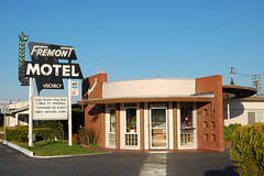
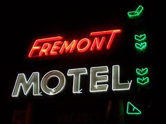
This motel is a particular favorite of mine, as I love the design of the building as much as its wonderful neon sign. I got to talk to the manager (and possibly the owner) when first photographing the sign at night and he seemed as fond of it as me. It is from him that I first learned of the city ordinance and the impending destruction. I don't see how this could possibly be considered a blight on the city that would hold it back from prosperity. To me it’s a treasure.
The Dude Motel and the Golden Motel
1501 & 1917 West Capitol
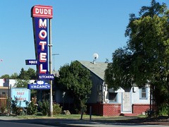
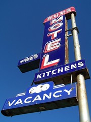
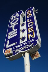
Just two old motels that managed to keep the same name and the same sign in good repair for all these years until the city intervened.
King's Chinese Restaurant
1500 West Capitol
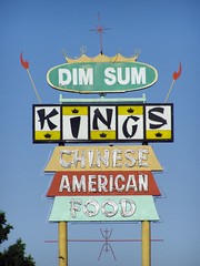
What a beauty! Yet it didn't inspire me to eat there until after the sign was gone, I'm ashamed to admit. This was a massive sign that towered above everything, a true West Sacramento landmark.. Perhaps it was out of spite (a waiter there told me the owner was very upset to have to remove the sign) that it was replaced in 2005 with the most lowly and unobjectionable sign you can imagine, a small, back-lit, plastic thing hugging the ground. Now that's a "low-rent" sign, a term city officials have used repeatedly over the years in interviews when talking about redevelopment efforts (although I now see that the sign has been placed on a pedestal, making it look more typical). The old sign was first class. See it at dusk.
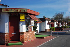
Budget Motel
964 West Capitol
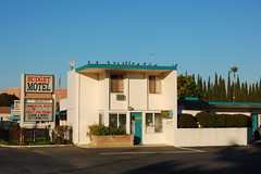
This was built in the early 1950s as the St. Francis Motel, advertised as "THE HOUSE OF DISTINCTION." It was still the St. Francis as late as 1980, but was the Budget Motel, with another boring new sign, by 1990. The office building is original though.
The Flamingo Motel
920 West Capitol
This motel never captured my eye, until I saw a postcard in the Sacramento Room of what the sign for it used to look like. One of my contacts on Flickr has posted his photo of that sign here.
Capitol Bowl
900 West Capitol
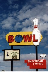
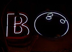
Formerly the El Rancho Bowl, the neon signs on the building should be allowed to stay under the ordinance, as long as they are in good repair, but the free standing sign with a bowling ball for the letter "o" is likely doomed. People have told me that the owners always kept it in good repair, but part of it was flickering weakly when I photographed it at night, and there's no point in spending money to repair a doomed sign.
Old Town Inn
826 West Capitol
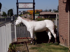
The horse statue standing outside this motel always struck me as peculiar, but it might have been part of the original decorative scheme, as before this was the Old Town Inn, it was the Pony Express Inn.
The Experience Lodge
824 West Capitol
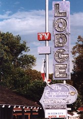
This sign featured a diving beauty and a mixture of neon tubing and incandescent bulbs, a style that is a particular favorite of mine (see Plaza Hof Brau at the corner of Watt and El Camino for a fine working example). It has been gone for a few years now, although the motel is still in business, again with a plain and unobtrusive plastic, back-lit sign.
Welcome Grove Motel
600 West Capitol
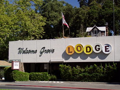
Motel and trailer park, actually. Plus, there's a small house sitting on top of the motel. The approach to the Tower Bridge in this area is being reworked, and I don't know how that will effect the Welcome Grove.
Tower Bridge
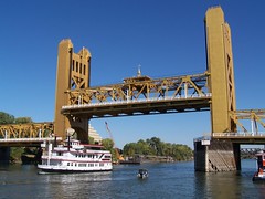
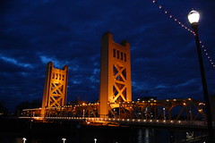
The bridge has marked the transition from West Sacramento to Sacramento since it opened on 15 December 1935 is closed right now, but just temporarily, as the sidewalks are widened. The future of this structure is secure as only the Capitol Building rivals it for status as the representative landmark of the city of Sacramento.
For 25 years this was the main portal for traffic entering Sacramento from the west, as Mayor Arthur Ferguson envisioned it in his comments during the opening ceremony: "These towers shall stand through the years indicating the true friendliness and welcome of the City of Sacramento" (qtd. in Sacramento Bee 12/16/1935).
Once the freeway was opened on June 15, 1954 bypassing West Sacramento, the bridge became a real bottleneck for traffic, especially since the train tracks crossed the approach to it. This was not alleviated until the Pioneer Bridge was finished sometime in late 1966, carrying the freeway across the Sacramento River.
-----
Highway 40 continued:
North Sacramento's Del Paso Boulevard
Auburn Boulevard