[See also my other blog entries on US 40,
West Sacramento's Motel Row, and
North Sacramento's Del Paso Boulevard. I periodically update these entries as I gather more information and photos.]
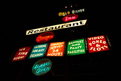
As automobile ownership, travel by car, and building of highways exploded all over America, the highway routes just outside of city limits were where auto camps, then motor camps, then motor hotels, and finally motels sprang up to meet travelers' needs. The motel row approach to the city of Sacramento from the west along the Lincoln Highway, and later US Route 40, was locally known as the
Davis Highway--what is today West Capitol in the city of West Sacramento. The approach from the northeast was to the once-separate city of North Sacramento along Auburn Boulevard. Dozens of mom and pop motels lined the route, trying to lure in visitors with bold neon signs.
Auburn Boulevard begins where it crosses the freeway that supplanted it as US Route 40--to the north it is Roseville's Riverside Avenue in Placer County. But heading south, it is Auburn Boulevard, beginning in Citrus Heights, and ending at El Camino where the city of Sacramento meets an unincorporated part of the county formerly known as Ben Ali, and now part of the larger community of Arden Arcade.
During World War II, plans were made for a post-war freeway in the Sacramento area, supposedly for defense purposes. In 1947, the North Sacramento Freeway opened, bypassing the city of North Sacramento, and that section of Auburn Boulevard from El Camino north to just past Marconi, where Auburn Boulevard curves in a more easterly direction.
In addition to the freeway bypass, the proximity of the railroad tracks helped to speed the decline of the businesses along this section of old Route 40. This portion of Auburn Boulevard did not even remain a main thoroughfare for residents, as the overpasses across the railroad tracks for major streets that used to intersect Auburn Boulevard now make them pass over it. This makes just following the old route difficult at times. Instead of keeping straight on Auburn Boulevard, a few times the road curves to the right and a stop sign, and you have to make a left-hand turn to continue on Auburn Blvd. A larger detour is required when you get close to Business 80 (originally the North Sacramento Freeway) and Marconi. This area, from El Camino to Business 80, once lined with motels and restaurants, is now predominantly light industrial, as a result of being bypassed.
The motels and restaurants along the next stretch of Auburn Boulevard survived quite a bit longer. When the Roseville Freeway was proposed to bypass this stretch, the Auburn Boulevard Improvement Association was formed to fight it. They sought to make Auburn Boulevard an express way, rather than having a freeway bypass it altogether. In 1948, the State Motor Hotel Association joined in the struggle to prevent construction of the freeway. But in the world view of most Americans at the time, it was self-evident that freeways were essential for progress and security. Nobody ever asked why. The Ben Ali-Roseville Freeway opened on April 24, 1956.
Government officials have never had much sense of history, or sympathy for small business owners. After forcing through a freeway that cut off the businesses and led to their decline, a new generation of officials viewed the surviving businesses as blight, and sought to have them demolished. This is what happened to three motels I was lucky enough to see, before progress swept them aside: The Rolling Green, The Ritz, and the Pacific Motel.
The destruction of the Pacific Motel particularly upset me. I remember how delighted I was to see the place. Not only was the fabulous neon sign in perfect condition--and those old signs with exposed neon tubing require continual maintenance, which can be quite expensive over the years--but the grounds were immaculately groomed, with a lovely flower garden. This was not some absentee landlord neglecting a property, and the owner did not roll over for county officials. He fought, and lost, and the result is that today we are blessed with a cheaply constructed shopping center, the kind developers purposefully build not to last, but to tear down in 20 years.
Here's what little history of the route I've been able to preserve with my research and photos, starting from the border with the current city of Sacramento and heading out towards Citrus Heights and the limits of Sacramento County:
As US 40 left the former city of North Sacramento, it passed under the railroad tracks via a subway, then curved to the north from El Camino onto Auburn Boulevard. Before the subway was put it in, it was a dangerous crossing point, and the curve was originally dangerous too, and was realigned at least twice.
This is where the Curve Inn Motel used to stand, but now either an office building or part of the wider overpass that replaced the subway occupies the space now. The curve is still there, and shortly after it you hit an exposed section of cement that was the surface of US 40, as opposed to the more recent asphalt. The subway, made irrelevant by the overpass, was filled in as part of the Sacramento light rail project. Then comes . . .
Chima's Food Store1530 Auburn BoulevardStevenson's Grocery Mart in 1955, and Eng's Market in 1965, somehow they keep managing to sell groceries at this little store.
M&M Mobile Home Park1750 Auburn Boulevard
In the 1950s, it was pretty much the same, but named M&M Auto Court & Trailer Park
A&M Bottle Shop1840/1838 Auburn Boulevard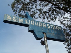
Sometimes it's not the name but the address that changes over the years. This placed opened sometime from 1957-1961, and is still in business.
Railroad Cafe1844 Auburn Boulevard 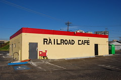
This was Bushers Club from at least 1952 to 1994, and the business was even older, being listed at 3040 Auburn Boulevard in 1950. I didn't see it as Bushers, but here is my friend
Mike's photo. It opened as the Railroad Cafe in April of 2007. I just had a nice burger there the other day.
Oak Haven Mobile Park2150 Auburn BoulevardIt has been around since at least 1939, when it was Oak Haven Trailer Camp. I don't know, staying in a trailer camp sounds more fun to me than a mobile park.
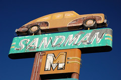
The Sands Motel2160 Auburn Boulevard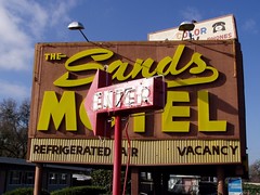
The motel is still there, but the county decided the sign was not solid enough. Apparently it took quite a lot of effort to tear it down. My photo here is not my own idea, but now I can't find the photo I copied to give credit to the person I copied it from.
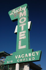
Pacific Motel2224 Auburn Boulevard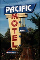
I've already told you about how I feel about this one. Wanton destruction. Developers Lux Taylor and Skip Maggiora wanted to built a shopping center, and in addition to their parcel of land, they wanted the land where the Pacific Motel and the Ritz Motel stood. Officials from the Sacramento Housing and Redevelopment Agency were threatening to use eminent domain to take the land if the owners would not sell to the developers. Patel in an article in the
Sacramento Business Journal in 2002: "If Maggiora wants to build a store, he should build it on his land only. This is not real fair."
Ritz Motel2228 Auburn Boulevard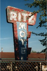
Destroyed.
Rolling Green Motel2230 Auburn Boulevard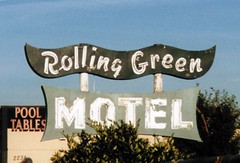
Destroyed.
Casa Grande Mobile Village2314/2312 Auburn Boulevard, or 3402 Killeen Circle49'er Motel2720/2730 Auburn Boulevard
Or earlier the 49'er Lodge, from at least 1948 to 2006. Now a lovely garbage-strewn vacant lot.
Transtar International2840 Auburn Boulevard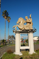
I've always been curious about this thing: a merman on horseback? Surely it couldn't have anything to do with Telstar International. In the 1960s and 1970s it was Zorba's Bar and Oven, but the building looks like it dates from when it was a nightclub called Cleopatra in the 1950s, as there are classical columns on the front of it.
Tradewinds Motel2844 Auburn Boulevard
Since at least the early 1970s, but before that it was the Town & Country Motel.
Johanna's Restaurant2906 Auburn Boulevard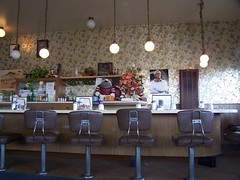
This place was a recent discovery of mine--it was Eddie's Irish Village Coffee Shop in the late 1960s, when the Econo Lodge next door was Eddie's Irish Village Inn. It has been Johanna's since at least 1990. It's not of the age I really admire for diners, the 1930s and 1940s, but it's still pretty cool.
La Rosa Blanca3032 Auburn Boulevard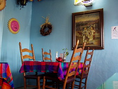
My very favorite Mexican restaurant. It's small, vividly decorated, and serves great food. It has been La Rosa Blanca since at least 1982, and in the 1960s and 1970s was Mission La Palma.
Surf Motel3204 Auburn Boulevard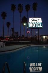
For a plastic, back-lit sign, it has a pretty cool one, but still I resisted photographing it. I love neon. The motel probably had a neon sign when it was the Palms Motel in the 1960s, but since at least 1971 it has been Surf Motel. Then I saw this
lovely shot on Flickr. I've since seen two more like it, and knew I needed a photograph of the sign as well, only I took mine at night.
Golden Tee Inn & Restaurant3216 Auburn BoulevardIt was built in 1964, after the freeway was, but was still an interesting place. The restaurant had a real Rat Pack feel. I never got a photo, but once again, a contact of mine on Flickr got
a shot.
Orbit Station4716 Auburn Boulevard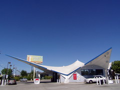
It's a pleasure to support this old googie gas station--it usually has some of the lowest prices in the area.
Cricket County Kitchen4745 Auburn Boulevard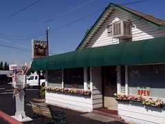
That's what it has been since 1986, and it is a delight inside--decorated with much kitsch, and model trains running around above your head. I'm no sure how old it is, but in the 1970s it was Pat & Mae's Restaurant.
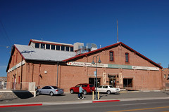
12 Mile House5919 Auburn Boulevard
We're all the way out in Citrus Heights now, but this is the most historic structure in my overview. It operated from 1884-1998, when a Bay Area investor who had purchased the property shut it down, telling the
Sacramento Bee she had no emotional stake in the property--it was just an investment. Ah, the discrete charm of the bourgeoisie. The previous owner who operated it for many yeas and told the
Bee of finding hand-made nails in the place, traveled from out of town to come back and visit the place one last time before it was closed.
Rocky's 7440 Club7440 Auburn Boulevard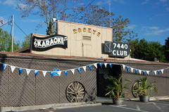
An old bar with utilitarian name, a great old neon sign, and a newer neon sign. Here's my friend Joe's
close-up shot of the sign.
Sam's Classic7442 Auburn Boulevard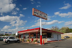
This is a great old drive-in restaurant that I neglected for too long. I stopped there for a chili cheeseburger and a Dr. Pepper on the way back from a hike recently. The burger was not photogenic, but it was delicious.
If you've traveled throughout the Central Valley, you might recognize this building as an old
Sno-White Drive In. There were once nearly 200 such franchises in California, and a few still survive. It was still a Sno-White in 1970, but by 1975 was Lou's Burgers.
 Lodge Coffee Shop8191 Auburn Boulevard
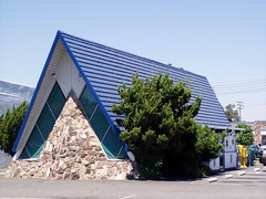
This was probably built in the 1960s, when A-frame coffee shops seemed to be all the rage, which would make it after US 40 was already bypassed by the freeway. It was previously called Ski Lodge Coffee Shop.
From here, Auburn Boulevard passes a major bus station for connecting Sacramento County and Placer County routes, and heads across the freeway that bypassed it into Roseville.
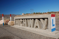
 highway40