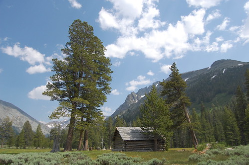
Andrew Thomas Kennedy's Cabin
I had been meaning to get to Stanislaus National Forest for some time, having bought a map of the forest more than a year before this hike. What finally precipitated my first visit was the Mother Lode Fair in Sonora. I drove down for the fair and camped at an RV park just outside of Columbia, then headed east on CA 108 into the Stanislaus National Forest the next morning.
My original plan had been to do a moderate hike (Camp and Bear Lakes) and an easy hike (Burst Rock and Powell Lake) in Pinecrest Lake area, both of which were rated a 9 for scenic value in California Hiking. But the hundreds of wilderness fires that had smoked me out of the Central Valley were reaching up into the mountains as far as the turnoff for Pinecrest Lake. So I drove past, and stopped shortly after at the Strawberry Inn for breakfast.
Oddly enough, there are two towns named Strawberry in California, both with lovely and historic inns. The other one I have seen many times, on US 50 in El Dorado County. The restaurant at this one, Restaurant-by-the-River lives up to its name. The dining area has plate glass windows with a lovely view out on the South Fork Stanislaus River. I had a delicious open-faced omelette with sausage, red onion, and feta cheese, served up by an alluring young waitress with a European accent named Svetlana. It was all quite charming and looking at the hazy, but still bluish skies, I was feeling more optimistic about my originally planned hikes.
I drove back, but as I got close to the turnoff, the smoke was getting noticeably worse, both by sight and smell. So I just turned around and decided to head farther east and farther up into the Sierra to try and get away from that smoke. I had also originally considered a hike to Kennedy Lake, so I checked the map to see where the trailhead was, and then decided to do that one.
I made one quick stop on the way, for the Donnell Lake Vista. There just off the highway is a parking lot and an easy paved path out to an overlook over a large lake in a steep canyon that I will probably never be able to visit. It is legendary for it inaccessibility. A few people who live in the area have fishing boats tied up and can take a steep hike down to them, but there's no point in going down there without a boat or kayak, as there is no shore. Besides the dramatic canyon walls, there is a hanging valley waterfall, just like those that made Yosemite Valley so famous. It was a tantalizing view (marred by the haze, and impossible to photograph except in a panorama) and then back on the highway.
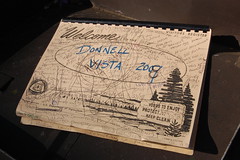
The Over Full Register for Donnell Lake Vista
The trailhead is near Kennedy Meadows, an extremely popular area. I saw a series of forest service campgrounds as I approached the large trailhead parking area. As I parked, there were people camped a very short distance directly in front of me.
I started off down the trail. A sign indicated "Wilderness 1 1/2 Miles" and then I immediately reached the road I had driven in on. I went farther down it, and saw private cabins off to the right by the Middle Fork Stanislaus River. Then follows an area with signs everywhere indicating it is for day use only, and no camping or overnight parking is permitted. But it looks like there were spots meant for parking--a flat area off the road, with a row of large boulders a little more than a car length away from the road. I wondered if I could have parked their just to shorten the hike a little, but nobody else was parked there.
Thinking I was past the camping area, I was disappointed to come upon an RV campground, which I believe is on land that is still privately owned. I crossed a bridge with "1955" on it and saw more RVs and a sign nailed to a tree advertising pump service.
Next up was the Kennedy Meadows resort area, and I was really dismayed. There was a large building with a store and restaurant, many cabins, RVs, trailers, one of those huge dumpsters they use at construction sites, and all kinds of equipment. It looked like they had just brought in everything and dumped it everywhere, without consideration for the surroundings at all.
In researching it later at home, I found the old lodge their burnt down in the fall of 2007. There had been a lodge there since the 1880s, with the previous one also burning down in 1941. I assume the mess is just during the rebuilding time, and it won't stay like that, although it still won't be wilderness.
Wandering through the ugly mess, I finally found a gate to a dirt road towards the southeast that said cars and bicycles were not permitted beyond that point. Since the map just showed the road ending and becoming trail, I headed that way, but there were no trail signs. I passed another camping area with tents, and an area where sprinklers were running, as I climbed up the road to go around a large granite knob between me and the river.
There was a large tank on the right, and then another gate, just beyond which was a trail sign, with a footpath heading off to the left. Unfortunately, all that it indicated was that the footpath was Night Cap Trail. That meant nothing to me.
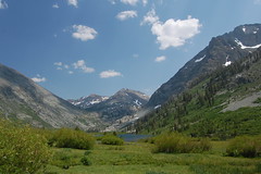
Soon I entered Kennedy Meadows, a gorgeous area. Next to the river is a large meadow with grasses and wildflowers. Across the river rises a ridge, but the real drama is to the east, where a huge, rounded granite half-dome is backed by snow splotched peaks. The only thing marring it is the wide and dusty road.
It was a beautiful scene, but soon I returned to campgrounds! Moreover, in the campground just past the meadow, there were cars or trucks parked next to every tent, and 4 plastic outhouses like you would find at a construction site.
Just past this there are two signs for the Emigrant Wilderness--one with a map and information, the other simply the official boundary marker. From here on I was happy not to see another car, truck, or RV. But it's still not a trail on which you are going to feel remote from civilization.
Rather than a footpath, the trial continues on at the width of a road from here, although too rough for cars. The hike started to get interesting as I crossed a steel bridge over raging waters. Once over the steel bridge, there is another trail that comes up to join the one I was on, with no indication of where it is came from, but just a sign indicating the trail was up and to the left. It's a steep climb here on a ledge that must have been blasted out of the cliff. A long ways down off the edge of it were rushing white waters, and farther up, excellent waterfalls. I had left my neutral density filter and Gorillapod in the car, as I didn't think I'd have time to stop for long exposures on such a long hike, and I had no indication from the hike description that there would be waterfalls. I definitely regretted not having them.
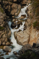
A second bridge crosses the water right below another waterfall. I wondered at the high sides on the bridge--tall posts with metal wire strung between them. It seemed like overkill. On reading a description of the trail when I got home, I learned why. Apparently it is for the safety of people on horseback. Fall off your horse, and you could fall right over a regularly sized railing.
Just across this bridge was a pulley with a large braided metal ropes that had snapped clean off, and later on some sizable pieces of rusted machinery. These, and the road itself, such as it is, are the remnants of the Sierra and San Francisco company's efforts to construct the dam for Relief Reservoir in 1909. The trail must have been designed for pack animals, and it is still heavily used for that. I saw evidence of that on the trail long before I encountered horses, as there were plenty of droppings, both fresh and stale.
Also just across this bridge the trail appeared to me, on the way down, to branch off in two directions. But I didn't notice it when climbing up, and took the left path without noticing the other. This area is rougher still, with some switchbacks, and climbs to a signed junction, straight ahead going on towards Relief Reservoir, and to the left, and noticeably climbing, in comparison to the flat trail headed the other way, for Kennedy Lake. The sign was the first indication I had on the trail that I was actually going to Kennedy Lake. Starting up, I could see a building on the Relief Reservoir trail that indicated it was the PG&E Relief Station at 7000 feet.
The steep climb continued from here. I was not prepared for this. I can't find any precise data on this trail, but from using the information I can find, I'd estimate that it's 1.5 miles with negligible elevation gain (some minor ups and downs) to the Emigrant Wilderness boundary, then 1.1 miles with about 700 feet of climbing to the junction I just described, and another 800 feet of net elevation gain (with ups and downs, meaning you're doing more climbing that than) the rest of 3.8 miles of trail (it's still a ways to the lake after that), with much of that in the first mile. California Hiking says it is only 1,200 feet of climbing, but Kennedy Meadows is between 6,200 and 6,400 feet and Kennedy Lake is just over 7800 feet (7801 on my topographic map, 7805 on a website), so that figure has to be off by close to a third.
Anyhow, it's nothing extreme for climbing, but it is mostly concentrated in one section, so that part was tiring, and combined with the length of the trail, you can understand why it was listed as a 2-day backpacking trip, rather than a day hike, as I did it. Most of the people I saw on the trail were backpackers or on horseback.
As I said, as I left the junction, I began climbing and had a fabulous view of the area I had left behind before turning away from the cliff to hike past a pond, which is still marked on my topographic map (at home, on the computer--I didn't have one with me, which would have made things easier) despite being quite small. Soon the trail comes out on a ledge again, with views of a lovely granite area scoured by Kennedy Creek.
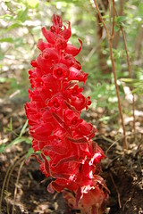
Snow Plant
I was thinking the trail should be down along the creek, but soon after rock hopping across a stream I descended to a bridge across it. Ultimately the trail heads to the source of much of that water, but since the water doesn't always take the easiest grade downstream, the trail sometimes has to depart it to get around obstacles, but it keeps coming back to it.
Climbing up after this third and final bridge, I passed another junction with Night Cap Trail before encountering horses for the first time on the trail, a man on horseback leading four horses roped together, and an another horse that was following behind on its own. As is the rule, I stepped off the trail to yield to the horses. I imagine on the weekend you might have to do that a lot on this trail. I saw several more people on horseback, sometimes leading pack horses, over the rest of the hike.
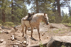
Riderless Horse
Around this point the steady climbing ended, and the trail become one of alternating ups and downs for a while, before evening out. I came upon a small meadow with shriveled irises, then continued on through light forest, often within earshot of the creek, and with occasional glimpses of meadow and the high mountains on either side.
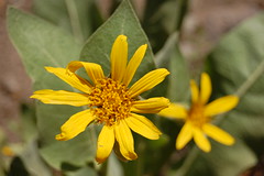
Woolly Mule Ears
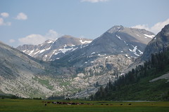
This even section of light forest was long, but it was easy hiking. Eventually I came out of the forest onto the top edge of a meadow--a magnificent and enormous meadow dramatically set off by soaring snow-spotted peaks. And there was a barbed wire fence: the trail followed the top edge of the meadow as it gently sloped down to Kennedy Creek, but most of the meadow was fenced off. Walking farther, I saw llamas grazing in the meadow on the other side of the fence, and tents set up near the river.
I came to a closed gate with no signs on it of any kind. If I was supposed to pass through it, I would expect a sign telling me to close the gate afterwards. If I was not supposed to go through it, I would expect "PRIVATE PROPERTY" or "NO TRESPASSING" signs. Property owners in scenic areas usually have these plastered everywhere.
I went ahead and proceeded through the gate and out onto the vast meadow of Hollywood Basin. The water drizzles down the meadow all over the place to the creek and so the meadow was very boggy, and I had to pick my way across it, trying not to sink too deeply in mud, although my right boot did go under at one point. There were many light green, almost cyan, shrubs here, and plenty of irises too (western blue flags). I see a lot of irises hiking on the coast, but I don't recall seeing them like this in the high Sierra before.
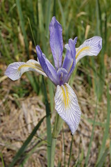
Western Blue Flag
Just before an old cabin, Andrew Thomas Kennedy's old cabin, I would read later on, the trail split. I figured the fork to the left was for people going to check out the cabin, while to the right looked like the way to go. I took that fork, and before long, the trail petered out. I could hear voices of people on the other side of the creek, but I didn't call out to them to ask where to go because I was afraid I might be on trespassing on private property after having passed through that gate. I was at the point of giving up and turning back, when I realized I should at least check out the other fork before the cabin.
I took that, and it took me quite a bit farther, but the trail was growing less distinct as I had to keep finding ways to get around or over the water and mud. A herd of cows was up ahead, and upslope from them was a family of 4 with two dogs. The father had a fishing pole, so I figured they likely came from the lake, and so I left the trail, such as it was, that I was following to head towards them. This led me to skirt around the herd, rather than pass through it.
Hollywood Basin
I asked about Kennedy Lake and the father pointed and told me I was just about to it. In studying the map when I got home, the trail doesn't actually go to the lake. It just goes a ways into the meadow downstream of the lake, and then you just have to find whatever way you can to best cross the meadow. It might be a problem earlier in the year when their is more runoff, but was easy enough at that time. Close to the lake there were some large bushes, and a red-winged black bird flew out of one and started flying around up above me, making a lot of noise. At first I wondered why it just didn't fly away from me, but then I figured it was likely protecting a nest and trying to tell me to go away.
Kennedy Lake Up Ahead
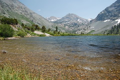
Kennedy Lake
The shore that you first come upon is just boggy meadow, and there's no really clear outlet to the lake. It just gradually narrows until it is a creek To get to good shoreline, you have to go to the end of the lake, where there are rocks and upslope a ways a lovely grouping of aspens. That's where I stopped, but farther around was a fisherman. I believe to get to camping sites you have to go completely around the lake and downstream a ways.
It took me 4 hours to get to the lake, so I didn't have long to enjoy it, as I didn't want to have to drive over mountain passes at night. I had originally hoped to go swimming, but I couldn't even keep my feet in the water very long as it was so cold. I stayed for half an hour, then started the long hike back. California Hiking puts the distance at 7.4 miles one way. I'm not sure if that's to the end of the trail, or to the lake. According to my Topo! software, it's about 3/4 of a mile from the end of the trail to a decent spot to stop on the lake. Anyhow, it's about 15 miles round trip, give or take a little.
On the way back several red-winged blackbirds harassed me as I crossed the meadow. In the lightly forested area, I turned on the speed, since only this and the initial part of the hike are areas you can really make good time. When I came to the junction with Night Cap Trail, I considered taking it, as I like variety, and I know from having seen the junction sign near the beginning that it would lead me back to the same place. But not knowing what would be involved and needing to make good time, I decided to just go back the way I came. On reading about it when I got home, I made the right choice. It goes quite a bit higher, and is apparently a faint trail. It was used as an alternate route to drive cattle up to the meadow (from what I can tell, a family owns grazing rights on the land, but not the land itself), particularly one year when a bridge was out.
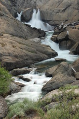
When I got all the way back to the waterfalls, I did stop to attempt long exposures, but I couldn't get them very long without my neutral density filter. They were in direct sunlight when I hiked out, and they were in direct sunlight on my way back.
Back down in Kennedy Meadows, a California Conservation Corps van and a pickup drove past me on the dirt road, kicking up lots of dust in my face. A guy gave me an apologetic look out of the passenger side window of the pickup.
Finally I made it back to my car around 6 p.m., 8 hours and 10 minutes after I set out: 4 hours out, 1/2 hour at the lake, 3 hours and 40 minutes back. I believe that is the longest day hike I've ever undertaken on my own.
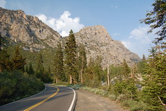
Sonora Pass Highway
For speed, I should have driven home by going back the way I came, but I really wanted to see Sonora Pass, which is just beyond Kennedy Meadows on CA 108. It was, indeed, a spectacular drive--along with the Shoreline Highway (CA 1), probably the most beautiful road that I have driven (I've been a passenger on some spectacular roads in Montana and in Norway, but I didn't drive). But on the other side of the pass, it was a long ways to go to get back to Sacramento. There's nothing to make your legs stiff like a 15-mile hike followed by a 4 1/2 hour drive.