Several nuisances got to me at the drive-in campsites at state parks--people running generators, several families gathered together to party, and people driving into the campgrounds late at night. The most popular drive-in campgrounds are also usually booked solid for Saturday nights in summer, while most of the environmental campsites are first-come, first-served, and from what I have seen so far, don't fill up entirely. Finally, they're cheaper. In this case, a drive-in campsite would have cost me $25, plus to even get one I would have had to reserve in advance, paying another $7.50, while the hike-in site was only $10 for the night. But unlike camping in the wilderness, I would have access to a pit toilet stocked with toilet paper, there would be other campers around in case I had problems, and a ranger would have a record of where I was.
I had a couple of bad omens about this trip on my way to the park. I stopped downtown in Sacramento to eat breakfast at Jim Denny's, and got a parking ticket. I had purposefully taken quarters to plug the meter, but just spaced out when I went into the restaurant. I also locked my keys in my car in Pescadero. I stopped for lunch and to check my map. I put the keys on the passenger seat, found the map and studied it, opened the door, locked it, got out, and just as I closed it thought, "my keys!" So I had to call AAA, and sit there on the one street in town and watch the man come out of the repair shop, hop in his truck, drive 1/2 block to my car, and look for me. I had an instinctive superstitious reaction to wonder what was going to go terribly wrong with my hike after that kind of a start to my trip, but I quickly put that thought out of my head.
At the entrance the ranger clarified that I meant Trail Camp, which requires a 5-mile hike to get to, and not the walk-in campsites in the main campground. I did mean Trail Camp, but the funny thing is that I had been telling my friends at work that week that I would be hiking in just 2 miles. But even with a fully loaded pack on my back, I was sure 5 miles each way would be manageable.
As you drive in from the coastal grasslands outside of the park, things suddenly change, and it seems as though you've been transported to someplace far away as you quickly enter a dark redwood forest with a cool stream running alongside the road. I parked at an off-road area just near the junction of the main road and a fire road, near the trailhead for Mill Ox Trail, which is what I started out on.
This trail took me across the stream and up the canyon wall at a fairly steep ascent for a person fully loaded with backpacking gear for the first time in his life. I paced myself, and occasionally stopped to adjust my straps.
After a very short distance on Mill Ox Trail, I turned east onto Jackson Flats Trail. The parking area was just below 400 feet in elevation. The junction with Jackson Flats Trail is a little higher than 400 feet. With modest ups and downs, the trail climbs to about 800 feet at the next junction over a course of about 2 miles, maybe a little more. There weren't many redwoods along this trail, but it was a nice forest with a some wildflowers, particularly monkey flowers. I didn't take pictures of them though. I hadn't thought of it beforehand, but it's not so easy to get down on the ground and take macro shots of wildflowers and mushrooms (as I usually do on a hike) with a fully loaded pack on your back, and it's even more difficult to get up again when you do.
The junction where I left Jackson Flats Trail took me onto the appropriately named Canyon Trail, which curves around the canyon wall. Everywhere a seasonal creek has cut back into the the side of the canyon, the trail follows the contour back as well, dips down to cross the creek bed, and then rises up on the other side and moves back towards the main canyon.
Canyon Trail is quite varied for habitat. Some parts are exposed and dry, and feature chaparral--mainly manzanita and scrub oak. Other parts are shaded and damp, and lush with ferns and heavy forest. It keeps alternating.
From around 800 feet of elevation at the junction with Jackson Flats Trail, Canyon Trail climbs to around 1300 feet at the junction with Indian Trail and the .5 mile spur to Trail Camp (I'm not sure if that .5 miles is included in the total 2.75 mile length of Canyon Trail or not, but I suspect it is). But there's more climbing than just 500 feet, because of the ups and downs.
The final .5 miles climbs to just over 1400 feet and an old road, off of which are the 7 campsites for Trail Camp. The first sign I came across was for campsites 7 and 8, but it turns out there is no camp 5. I think a large tree may have fallen where it used to be.
The ranger told me that two groups had been ahead of me going to Trail Camp, but there was nobody around that I could see or hear. I hiked past the pit toilet and trash cans up to the sign for campsites 1 and 2, which was also signed for Chimney Tree Trail, a trail not marked on my map. I presume Chimney Tree is an old-growth redwood tree. I started along that trail but didn't see any campsites, and soon turned around as I was entirely exhausted, and didn't need to do any more hiking with my backpack on.
I chose campsite 3. The campsites are all nicely secluded off short spurs from the road, and include rough-hewn picnic tables and benches made form large logs, although the table had collapsed at my site. I pitched my tent, arranged everything as I wanted, rested a while, and then headed out again, this time carrying nothing but my camera.
I headed up the road to the junction with Butano Fire Road, and took a short climb westward up to over 1600 feet to Ray Linder Memorial Trail, a 1-mile loop trail through forest with redwoods and Douglas firs. I saw a couple of slugs on the trail, and tried to get some good shots, but with frustrating results because it was so dark in the shady forest. I finally broke out my Gorillapod to get longer exposures, but wasn't too successful with that approach either, as my model was ducking his head under some leaves.
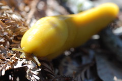
Banana Slug
? on Ray Linder Trail
The trail does some climbing and dropping before returning to the fire road, just a ways down from where I had started out on it. I headed back to camp, but then decided to go out on Butano Fire Road one more time, this time to the east.
Once again I climbed to over 1600 feet, this time on a broad and smooth dirt road that was in better condition than some I've driven to trailheads on. I climbed past some graffiti, and caught glimpses of the valley below before arriving at my destination, an abandoned landing field. I was expecting it to be paved, but it wasn't. There's no information in the park brochure that would indicate why it is there, but it's clearly marked on the map. There were plenty of bicycle tracks around, as bicycles are allowed on the fire roads. You could get all the way to Trail Camp via bicycle.
Then it was back to camp again. I fell asleep pretty early, before having my usual fitful sleep while camping. As soon as it started to get light out, I stopped trying to force myself to sleep longer, and got up and got ready for my day. I was all packed up and ready to start back to my car by 6:30. Everybody else in camp was still asleep.
I went down to the last junction I had come from, and this time turned onto Indian Trail, rather than Canyon Trail, as I had come. I noticed that someone had left messages all over the post of the sign, warning of a wasps nest near a pond, and of the difficulty of one of the trails.
Just a short hike downhill from the junction I crossed a creek at a lovely spot--the canyon walls were steep enough that fallen trees came all the way down and were littered across the creek, in large piles at points. Following the usual pattern, once crossing the creek, it was uphill.

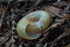
On Indian Trail
Soon the creek was far below, although not so much because the trail I was on was climbing, as that the creek was dropping. Indian Trail only runs .9 miles until it hits a fire road along a ridge, Olmo Fire Road. On this portion of the hike, I could see the valley of the park to the right (north), and the next valley south on the left, and a fire road on top of the next ridge to the south. I was finally out in sunshine, the first I had seen that morning.
When building roads for automobiles they don't worry so much about ups and downs as they do when constructing foot trails, so I soon found myself hoping to find my next junction before having to make another uphill climb. It was hidden until I came right up to it, but just at the start of a big ascent was the sign for Doe Ridge Trail.
This trail of just 1.6 miles was one of the nicest parts of my hike. It gently sloped down, making for easy hiking, and kept moving deeper into better redwood forest as I went along. It culminated in an area at the end of the descent with some fantastic old specimens and stumps just before a short rise and the junction with Goat Hill Trail.
I took Goat Hill Trail down and quickly hit the junction with the trail to the main campground. I could have turned off here and quickly been back to my car, but I wanted to go a longer route so that I could hike Little Butano Creek Trail, which looked to be the loveliest trail in the park. So I kept going south until I hit a fire road, on which I turned right (east).
Once passing some sort of utility building for the park that was humming and was accompanied by a big black tank, the fire road was as lovely as a road can be, gently sloping down and curving gracefully, while over-towered by many redwoods, and with ferns dripping down off the banks on either side. But I was quite a ways up off the canyon floor, where Little Butano Creek had to run, so I knew there would be some more elevation changes.
Soon enough the road dropped steeply--steeply enough that I slipped at one point--down to a bridge that crosses the creek. On the other side (north) was a sign for the Little Butano Creek Trail, and odd sign that resembled a simple headstone. Instead of getting to stroll along the creekside as it gently descends towards the park entrance, I immediately started up, and then back down to the creek, and then back up. There was going to be a good bit of climbing. It is gorgeous scenery though, a steep canyon covered in ferns with the creek running through the middle and the redwoods rising high above and casting everything in deep, dark coolness.
Then at one point as I rounded a curve, I felt a sting and heard a buzz--I'm not sure which was first, or if they were simultaneous. Some flying insect (I never saw it) stung me right on the jaw. There was a small, sharp pain. I was worried about swelling, as the last time I had been stung by a bee, 20 years earlier, my whole forearm had swollen up and turned red.
That would prove to be the least of my worries. I soon grew lightheaded, and my heart started to race. Then itching began far from the sting--on the tops of my feet. It was so irritating that I wanted to rip off my shoes and scratch away. Soon everywhere else started itching. My ear drums started throbbing, and they too started to itch. But what most scared me is when I started having trouble breathing. I'm used to having my heart race and to panting heavily when doing a lot of climbing on the trail, but now I was wheezing and coughing.
I went slowly and took breaks. At one point I stopped, took off my pack, and dug out my first aid guide. It described my symptoms as anaphylactic shock (I believe now it was just an anaphylactic response, shock would have been more severe, but that's what the first aid guide said it was), but had no advice on what to do, other than seek medical attention. I was only about a mile from the end of the trail and my car, but I hadn't seen or heard anyone since the campers near me quieted down near midnight the night before. I just kept on slowly. It didn't seem as though I were in any immediate danger of collapse, but I did find myself wishing that I had my ID on me, in case it were needed.
The last part of the trail was flat and easy, following the course of the stream. Also quite lovely, I'm sure, but I was too busy concentrating on my pacing and heart rate to notice. A couple came into view here, and from their appearance I guessed they hadn't wandered far from their car. Figuring I had made it back, I didn't appeal to them, but just said hello. They didn't seem to notice anything amiss about me.
At the car I dumped my pack and lied down on the backseat of my car. My breathing and heart rate calmed, and I didn't feel lightheaded. But when I heard an insect buzzing, I decided it was time to go. I wasn't yet ready for round two.
My original plan had been to check the drive-in campgrounds bathrooms for pay showers, then use my entrance fee for the park to get into the state beaches up CA 1 on my way back home. But I decided to head straight back to Sacramento possibly stopping for medical attention if needed.
Sitting in the car not exerting myself at all, I didn't have much problem with my breathing, heart rate, or lightheadedness, although initially I was itching, and scratching, all over on the way back, and I saw red welts break out all over my thighs. But things calmed down. I even stopped to take a picture of a sign, although the lightheadness I experienced standing up made me regret that.
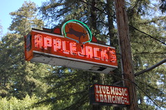
Worth the Stop?
As I got closer to Sacramento, however, I felt better and better, and finally ended up going home, rather than to a clinic. All of the systemic reactions had subsided, but the local results of the sting were just starting to develop. My swelling occurred, not only at the point of the sting on my jaw, but on the lower part of my throat and upper part of my chest, culminating about 36 hours after the sting, and then subsiding after that (with me treating it externally with cortisone cream and internally with antihistamines). I had never heard of such a thing as anaphylaxis, but in discussing it with people at work on Monday, I found everybody else knew of it--they had either experienced it, or knew someone (or heard of someone) who had.
That was the big adventure of my first backpacking trip. The fact that things went wrong doesn't surprise me at all, but the way in which they did I couldn't have anticipated: my first parking ticket in 15 years, my first time ever locking my keys in the car, my first ever anaphylactic reaction. I was worried about running out of water, critters trying to get into my tent after my food, or back pain from carrying that fully-loaded backpack so far. I'm not a superstitious person, and I know there was no connection between my absentmindedness with the parking meter and my keys, and the terrible allergic reaction to the insect sting, but even so I was driving very cautiously on the way home, thinking that a car wreck would be just the thing to complete the weekend for me.
I'd like to see what the park brochure describes as the "park's star attraction, the purple calypso orchid," which blooms February to April. But I'm not sure I'll be back to Butano State Park. It's very nice, and I won't hold my misadventures against it, but coming from Sacramento, it's a pain to get to it through the freeway maze of the East Bay and South Bay, and there are so many other places I have yet to explore.
3 comments:
Wow! What a bad trip. I'm so glad to hear you made it out Ok.
My hubby and son are alergic to insects stings. It can be life threatening. My son is a backpacker. He loves the Olympic National Park and prefers to go alone which scares me to death, so much can happen. We bought him a GPS which was suppose to work in the mountians, but didn't. He carries a kit with a shot of adreline just in case he gets stung.
My family finally got so sick of camping in drive-in camp grounds that we bought some property on a small lake. The drunk people and theives we encountered in public campgrounds were increasing every year. We have a grown adult daughter that is afflicted with Autism and she likes to pace. The last time we camped in a campground there was a couple who actually turned their chairs in our direction so they could watch Sarah. How rude!
The first time my son when out backpacking alone, he was on his second day and had not seen anyone. Suddenly he heard twigs snap behind him and expecting a bear or mountain lion he turned quickly and there standing all alone on the trail was boy scout. He asked him where he came from, but the child did not answer, just pushed past him on the trail. He said it gave him the creeps. When he got back on the 5th day...he asked the Ranger and he affirmed that there was a troop up on the trail. Evan just thought it was strange that he had not seen or heard them.
I guess the point of this message....like the Boy Scouts say...Always be prepared...Get an insect sting kit. Then you won't have to worry. I know....I can't help sounding like a Mom...I are one!
I hope you have more adventures in the wilderness and stay safe. Love your photos and blogs -Nicki Fuller Poulsbo, Wa.
Thanks so much for the support. I'm still not decided about getting the Epipen. At first I was leaning against it, now I'm leaning towards it. I'll have to read some of the medical literature before making up my mind
I don't trust the medical industry, which is geared towards selling you everything, and making you pay a lot just for the right to buy it (in Canada, you can buy the Epipen over the counter). I'll read the academic journals for the unbiased view.
sorry to hear about your allergic reaction. I took a wilderness first aid course and the teacher recommended a technique using Benedryl in an emergency situation if you don't carry an epi-pen... buy (and carry them with you!) the capsules that come in a gel case. Break it apart and poor the powder under your tongue. It tastes bad but your body absorbs it quickly. I can't advise on a dose, but it's something worth looking into.
Post a Comment