There are three ways to reach the summit of Pyramid Peak described on this handy website. Although it is the longest route, going via Lake Sylvia and the Lyons Creek Trail involves the least climbing (about 3300 feet of it), and at around 12 miles round trip is not as long as many hikes I take.
Seeing as how it is off trail and requires a good bit of scrambling, though, I felt it best to hike this with my friend Erik, rather than alone. We set off in October of 2007, but there was snow on the ground, and ultimately we decided not to go off trail, and instead we made a visit to Lyons Lake.

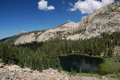
Lake Sylvia, October 2007
For attempt #2, we set out late in July of 2008. I had studied the map and a photograph from that website mentioned earlier, and thought it would be easy enough to find the way. We marched off to Lake Sylvia via the Lyons Creek Trail, and then it was time to climb to "the obvious notch SSE of the lake."
I've got to be honest. Erik and I are enthusiastic hikers, but we don't have much experience, and don't seem to be naturals at this either. We have some problems. Looking from the shore of Lake Sylvia, neither of us could spot a notch that was obvious. In fact, we had to get out the map just to clarify that north of the lake was Mt. Agassiz, and not Pyramid Peak--Pyramid Peak doesn't look like much of a peak or a pyramid from Lake Sylvia (although it does from the east). Additionally, the map made it look like we should just skirt the shore that we arrived at before starting up, which is what we did.

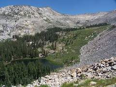
We should have been farther to the right in this photo
We tried to find the easiest way up, going gradually from west to east, climbing at a slant to what we decided was most likely our notch. But after a lot of work, and having to climb down and back up again on talus and slab to get around impassable objects, we reached a very steep portion with smaller rocks mixed with dirt--not good footing at all. We sent some rocks tumbling, and finally gave up, and went down the talus and slab portion with the largest boulders.
As we got down to the lake, I heard people discussing the way up and saw them pointing, and soon they started up. They headed towards the same notch we had been aiming for, but they started considerably more to the east. Rather than start climbing from the southwest corner of the lake, they started from the middle of the south shore, about where the trees end. We stayed and watched them, and more people who followed, and a man hiking down. They avoided entirely the steep portion with poor footing that had stopped us, and their route looked easier. Three guys who came later, though, climbed right up to where we had been, and made a very laborious ascent up the ridge from there, sending many rocks flying, and exchanging terse words with each other.
We had worked too much to start the ascent over, so we instead enjoyed Lake Sylvia--it was my third time there, but the first time I really spent time at the lake. And we went off trail following Lyons Creek for a portion on the way back, which took us through some lovely meadows where the creek meanders and has trout swimming in it. The trout are not native to streams and lakes above 6000 feet in the Sierra Nevada, but have been stocked there since the 19th century, and survive in some lakes and streams even in national parks in the Sierra Nevada, which are no longer stocked.
So we once again failed to make it up to Pyramid Peak, but at least we had scouted out the route, and knew how to approach it on our next attempt, which wouldn't be until early September.

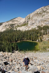
Erik on the talus
One bad thing about starting later in the season is that it means less time before sunset, and we got a late start from Sacramento too. We did much better on this effort, making our way, rather slowly, up the talus to the notch, and continuing up from there. There was no clearly blazed use trail, but the general way seemed obvious enough, and every once in a while we would come across a section of use trail on the steep climb. We got very high up, just below the peak and the final scramble up talus. But we were pressed for time at that point--there was a good chance that if we continued to the peak, we would not make it back to the car before dark. It's not like the peak was going away anytime soon, so there really was no pressing reason to risk it. After resting and checking out the outstanding view of a pond on the slope up above Lake Syliva, we headed back. We made it back to the car just after sunset, while there was still a good bit of light. That was it for climbing Pyramid Peak in 2008.

The summit of Pyramid Peak to the right

Ponds between Pyramide Peak and Mt. Agassiz
For 2009, I briefly considered a different approach--taking the shorter route (with more climbing) from U.S. 50, which is more popular, or camping at Lake Sylvia so as to get a very early start on the climb. But no, I had to finally do what I had set out from the trailhead three times before intending to do, and not done. No turning back this time, no excuses.
So at the end of July I set off, alone this time, and on a weekday, with the hope that it would be just me and the mountain. I took a mechanical pencil along to jot down the time at various points along the trail so I would have a good estimate of how long my return would be.
8:45 Set out from the trailhead along the familiar Lyons Creek Trail.
9:25 Passed junction with Bloodsucker Lake Trail.
10:37 Reached fork in trail, one way heading to Lyons Lake, my way towards Lake Syliva.
10:47 Reached Lake Syliva
10:52 Started up the talus from the south shore of the lake.
We had successfully completed this portion of the hike the year before, so I hadn't been too concerned about it, until I actually started it. Looking up the huge slope of talus was pretty intimidating, and I started questioning my decision to go on a weekday. There had been campers at the lake, but nobody was around climbing the way I was going. As I started up, someone at the lake started playing the harmonica. It was rather strange, climbing by myself over huge rocks, with just the sound of a distant harmonica and the wind in the trees now and then.
I took my time, and took breaks along the way up, looking down at the lake. I noticed that someone was standing on the north shore apparently watching my progress the whole time.

Taking a break
Closer to the top, there is solid mountain on the left and right, with talus in between, and above that dirt with loose rock. The left side next to solid mountain looked best to me, so I went up that way, but farther up there was a distinct use trail on the right side next to the solid mountain. Sometimes I skipped around sketchy looking portions that were definitely heavily traveled, but looked terrible for footing. I reached the notch at 11:37, so it took 45 minutes for me to climb up from the lake.
All accounts I have read of this hike are pretty dismissive of the next portion, saying the peak is obvious, and you just head up. But really, the route you take up the steep slope can make a big difference in how difficult the hike is. There are portions near the start that have ups and downs, rather than just continuing up, which make going more difficult, and there are sections of talus. But it is possible to navigate around them, and take an easier way up. The patches of use trail help.
I had mixed success in finding the easiest route. I would find a patch of use trail and then lose it, and then find it again, sometimes closer to the ridge than I had been traveling, sometimes farther away from it. I began to suspect that there were two distinct use trails, and I kept alternating between them.
I had to stop to rest a couple of times on the way up, and I ate my sandwich, the only food I had brought on the hike. Where I stopped there were lovely views of Lake Sylvia and a pond just below the notch on the other side from Lake Sylvia. Father up, I could see a couple of cabins in a beautiful meadow down to the southwest. I think these are the cabins in Upper Forni mentioned in Robert S. Wood's 1970 guide to the Desolation Wilderness.
1:00 Or a little before, I reached the spot that Erik and I had stopped at last year. I forgot to check my watch until a little later.
Nothing to do from here but face that boulder and talus climb. Again, it appeared intimidating, but also quite beautiful, with the rocks bespeckled with green and pink/peach lichen. There were a few trees out in the middle of the talus, indicating soil in that area, so I thought there might be some easier hiking. I headed towards one on the left, only to end up veering back towards two on the right. Near them was some soil where it was easier going, but it was a short patch. I knew what was down over the ridge to the left--a sheer drop. I thought maybe there was an easier ascent over the ridge to the right, but I figured it might also be a sheer drop that way, and the latter theory proved correct.
I was really panting and my heart racing, but I reminded myself it wasn't just the effort, it was because I was approaching 10,000 feet in elevation and the air was thin. I was finally going to stop and, but having just reached much smaller rocks, I could see the summit was very close. I decided I'd rather rest with a view.
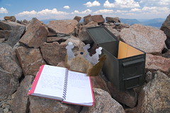
1:23 I reached the summit, 4 hours and 38 minutes after departing from the trailhead. There were several deep enclosures up there, where people have dug up the rocks and put them up as walls, undoubtedly nice for getting out of the wind on some days (not a problem that day). There was a container with the summit register, a cardboard crown for being king of the mountain, and various other bits. According to the register, one other group had been there before me that day, firefighters from Sacramento who came via the more popular route from U.S. 50.

But what about the view? I don't know any way to capture it in a compelling photograph, but it was stunning. There were too man lakes visible for me to be able to identify them all. Lake Aloha, of course, predominated, but I could also see Lake of the Woods, many small lakes, a fantastic cascade of water running down the granite between, I believe, Desolation Lake and Ropi Lake. Even portions of the Echo Lakes, Fallen Leaf Lake, and the south end of Lake Tahoe (and a couple of casinos) were visible. Even from that high up, I couldn't fit all of Lake Aloha in view with a wide-angle lens.
 .
.Part of Lake Aloha
I stayed for half an hour at the summit, and then started the long, but relatively uneventful, trek back. As I started down from the notch to Lake Sylvia, I fell on my butt, and got a small cut on my hand. I took it as a reminder to be cautious on that portion. I remember working my way down it pretty quickly last year, but I think I was definitely slower this year. I made it to the lake by 3:25, which meant I had plenty of time. The only reason I had to hurry back was hunger. I reached my car at 5:23, and headed off for dinner in Placerville.
1 comment:
We made our first attempt to the Pyramid Peak yesterday (just over 5 years after your successful climb). We started on the wrong side of the lake and it all went downhill from there so to speak (lots of climbing over "impassible objects") and we weren't able to make it to the top. It's inspiring to hear others' attempts and success story, now I feel more pumped to give this another go. Thanks for the post!
Post a Comment