Usually I plan the hike, as I have several hiking books and know many useful websites, and have the National Geographic mapping software. But I was busy researching old buildings in Sacramento for my non-hiking blog entries, and I just told Erik to check waterfallswest.com to find a good waterfall hike (to take advantage of our recent storms) at low altitude. He came up with the Steep Ravine Trail in Mt. Tamalpais State Park, and came up with another short hike that we could do if we had time. I thought that sounded great, and told him I had the information and the map for the first hike, and for him to bring the information for the second.
We got off to a slow start, as I was unprepared. After picking Erik up, I had to stop for gas, then for a breakfast burrito. Then we took a back route to bypass downtown Sacramento during rush hour. And there's just no getting around the fact that it's long drive to much of the coast from Sacramento.
We drove down to Vallejo, headed over on CA 37 just north of San Pablo Bay to Novato, then south on US 101 to Mill Valley, then north on CA 1 to just yards away from Stinson Beach, where we turned on the Panoramic Highway.
And then I think we drove right past the Dipsea Trailhead that we should have started at, to follow the directions from waterfallswest.com. We went up the winding a road a ways until I saw a gate with some trail signs beyond. They indicated Dipsea Trail and Steep Ravine Trail, so we started our hike from there.
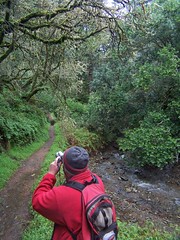
Erik Shooting
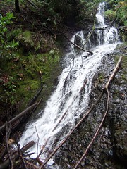
It wasn't long until we were in Steep Ravine, passing the junction for Dispea Trail, and what a beautiful location it is, particularly after recent rains. The trail follows the creek, with many small plunges producing plenty of white water, and a fewer longer falls. We were stopping to take photographs frequently, although the low light conditions on an overcast day made things challenging for us, as neither of our cameras can do a very high ISO.
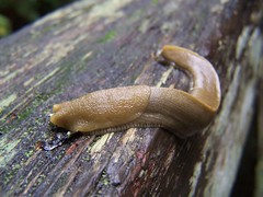
Banana Slug

Small Plunge
One of the things I was most looking forward to in the hike was the ladder--a portion where you have to climb a ladder up a steep rock face. Despite a warning sign about it .8 miles in advance, it turned out to not be much of a challenge. Erik was disappointed, complaining about the fact that it wasn't even completely vertical, but was on an angle.
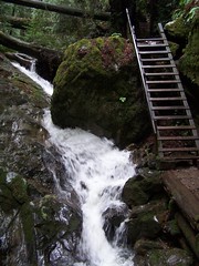
Easy Ladder
The hike climbs to the Pantoll Ranger Station, where there is a parking lot and a couple of roads. Looking at the map there, I saw that we left from the wrong starting point. If we proceeded according to the directions, we would go all the way down to CA 1 on Matt Davis Trail, then climb back up on Dipsea Trail to where we had parked. Erik was anxious to see the cascades on the other hike, so he opted to simply take the Dispea Trail back to where we parked to complete our loop in a much shorter distance.
So we just had to find a trail down to Dipsea Trail, and I finally spotted what turned out to be TCC Trail, which I have been on before. With all the recent storms, there were downed tree limbs and needles all over the trail, and a few times Erik questioned whether it was a trail, or whether it got much use. But I just marched on.
We got down to the signed junction with Dipsea Trail, and headed down on that. At first, the scenery was quite subdued. Had it been a clear day, we might have had wonderful ocean views--but it wasn't. Only when we got close to the junction with Steep Ravine Trail did the setting become enchanting again.
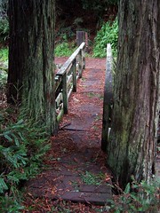
Bridge to Dipsea-Steep Ravine Junction
We were soon back to the car, and headed up to Pantoll Ranger Station to take a road from there to our next hike. But farther up, the road was closed, due to dangerous conditions. So we had to find my Bay Area map to find an alternate route. We settled on the Fairfax-Bolinas Road, which crosses CA 1 right at the north edge of Bolinas Lagoon.
Somehow we missed it. We drove all the way to Olema, and Sir Frances Drake Blvd. Erik let out a groan of disgust when we realized how far off we were, but there was no need to be disappointed. There are splendid trails all over this area. I suggested to Erik that we continue on Sir Frances Drake Blvd. to Samuel P. Taylor State Park, and revisit the site of a waterfall we had been to 50 weeks before.
Last January we hiked up to the top of Barnabe Peak, and took a small side diversion signed for a waterfall. But last year was unusually dry, and there had been no recent rains before our visit. There was a big drop-off at the end of the trail, but no water coming over it.
Erik was fine with that, so we pulled over in a parking area opposite the trailhead, and headed up the easily graded trail. There was one major obstacle in our path, where some trees had fallen on the trail, without there being any way around them. We had to twist and turn and hunch and stride to get through them.
Stairstep Falls
At the end of the trail, we had a lovely waterfall. Although it turns out we might have gotten more out of the short hike.
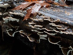
Mushrooms
One the way back, we ran into two men with a bunch of kids, and one of the men asked if we had spotted any salmon in the spring. We hadn't been looking. Later on, we met a young man, who asked the same thing. I didn't think it was salmon spawning season, although there were signs on the trail about salmon. We did watch after that, but didn't see any.
And then it was the long drive home. Mercifully, traffic wasn't bad at all.
Not having hiked in more than two months, I had almost forgotten just how delightful it was. Last summer I swore not to let a week go by without me getting in a hike, and returning from this hike with a spring in my step and a general feeling of well being, I wondered why I hadn't made greater efforts to hit the trails the last several weeks.
2 comments:
Hello-- love your work! I'm with Midtown Monthly magazine and would be interested in taking to you about your photography.
tim at midtownmonthly dot net
Yay for well being.
Post a Comment