Unnamed Pond
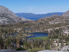
The Velma Lakes are a popular destination for hikers into the Desolation Wilderness coming from Lake Tahoe. The two trailheads that offer easiest access to these lakes are both along CA 89 on the west shore of Lake Tahoe, at Bayview Campground and at the parking lot for the short hike (1000 feet) to Upper Eagle Falls just above Emerald Bay on Lake Tahoe's western shore.
I made the hike to Middle Velma Lake in 2006 from Bay View Campground. The advantages of starting there are that it's easier to find a parking spot, you don't have to pay for parking (it's $3 at Eagle Falls), the climb is on an easier surface (mostly dirt), and early on there are some nice views of Lake Tahoe and Emerald Bay..
But this year I chose to approach the area via Eagle Falls, in order to see Eagle Falls and Eagle Lake. This route is more direct, but a lot rockier. I wanted a bigger challenge this year also, so I planned to add a lot onto my hike. Last year it was just Middle Velma Lake. This year I planned to visit 6 lakes, Eagle, Dicks, Fontanillis, Upper Velma, Middle Velma, and Lower Velma Lakes. It was an ambitious plan. I didn't end up making it to the last two lakes, but I still experienced an all-day, butt-kicker of a hike.
As I hit the road, I heard the traffic report on an overturned 18-wheeler on westbound I-80 between West Sacramento and Davis that had traffic backed up through downtown Sacramento. I was trying to get on eastbound 50, but as I came up onto Watt from American River Drive, my way was blocked by all the traffic backed up waiting to get on westbound 50. So I just exited on La Riviera and headed to another freeway entrance, where I had no problem. I've got a dozen different ways to get to anywhere in the area, and am ready to adjust my route according to the traffic situation at hand.
As I headed out on 50, past Folsom, El Dorado Hills, Cameron Park, and Shingle Springs I saw the usual blight of uniform, low-density, tract housing. I can certainly understand why someone would want to live in the foothills, even if they work in Sacramento. But I don't understand why people want to live in such uniform tract housing, going to major chain stores and restaurants, and obliterating all local identity. Tract housing is quite uniform in class, and people who live in such generic communities seem to identify more with people similarly isolated in soulless communities around the country, united by their cable and satellite television channels, rather than having a connection to the people around them, of all class levels, and the history of the land around them.
That's probably not a fair characterization of the people who live there, but when I was driving by I was upset over the news I had read in the Sacramento Bee about the unanimous decision by Placer County supervisors to approve the building of 14,000 low-density housing units in defiance of the regional growth plan approved by the Sacramento Area Council of Governments in 2004. As I got to less suburban Placerville and beyond, my spirits lifted.
The parking lot for Eagle Falls had a few open spots when I arrived, which was a lucky thing. I filled out my parking permit and paid my $3, and also filled out my Desolation Wilderness permit, but I left it in the car. I hiked up to Eagle Falls before realizing I had forgotten it, and returned to the car. The lot was full by then. A woman looking for a parking spot asked me if I was leaving. It would be about 7 hours before I left.
It's a steep climb, but only 1000 feet to Upper Eagle Falls, which was signed "Eagle Falls." But there's also the more impressive Lower Eagle Falls, below, and on the other side of the highway. There's a bridge across the top of the upper falls, and then just 500 feet later I reached the Desolation Wilderness boundary.
This has to be one of the most popular hikes into the Desolation Wilderness, with most people stopping at Eagle Lake, just 1 mile from the trailhead. It's a steep climb, but easy enough if you pace yourself, and the lake is gorgeous. Horsetail Falls also attracts lots of tourists who spot it off US 50, but because it can be a dangerous hike for novices, the Forest Service does not make permits available at the trailhead. You have to have planned ahead to hike all the way to those falls.

Eagle Lake
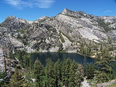
Eagle Lake, surrounded by towering granite cliffs, was a treat, and there were a good number of people there on a Thursday, around noon. In the afternoon on a weekend it would probably be overrun.
I didn't stay long, but continued up the trail. From Eagle Lake the trail rises on a ledge with fantastic views of the lake from above. After a while it turns into a forest and I lost my views, but gained some shade. It briefly dips to cross a creek that might dry up later in the year, then continues climbing. The trail comes out into an open granitic terrain where cairns and rows of rocks on either side indicate the trail. At one point the trail seemed to go several directions, but I think they all ended up at the same point.
Just Above Eagle Lake
Soon after, there's a brief drop, and then I was traveling along a ledge of a steep cliff, with a pond covered with lily pads at the bottom. On all sides of the canyon rose walls of granite. There's no problem with the footing here, but I didn't rush along, as a trip could have had disastrous consequences.
The trail rose up through some bushy areas, and across more granite, and suddenly I was familiar with my terrain. I was right at the junction with the trail coming from Bayview Campground, which I had hiked up the previous year. It was around 2.6 miles and 1620 feet of elevation gain to reach this junction.
I followed the familiar trail up and down until it split, left to Dicks Lake, right to Middle Velma Lake. Last year I went right; this year I went left. I began a short descent and arrived at a beautiful body of water in a short time. I assumed it was Dicks Lake. I stopped and took pictures, and then continued on the trail. I started climbing a lot towards the west. I knew it was a short distance between Dicks Lake and Fontanillis Lake, without much elevation gain. So I started checking my map and compass.
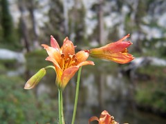
Tiger Lilies
I couldn't make sense of things. I could see from up on the slope Upper Velma Lake to the north, but couldn't figure out what trail I was on. It was a clear trail though, one which had been constructed, and couldn't be new (I don't think they would make improved trails in a designated wilderness area today). I was close to the top of my climb, and should have continued, but I didn't; I went back down to the body of water.
I now speculated that it was Fontanillis Lake and that I had missed the short spur to Dicks Lake. But soon that didn't seem to make sense either. I had been hearing people for a while coming from the direction I had just returned from, so I asked them when they reached me.
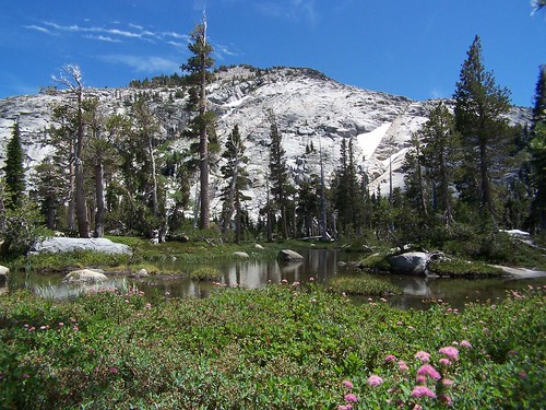
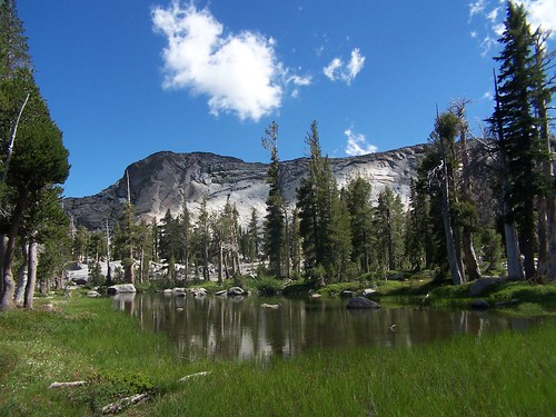
Nothing would have made sense of the situation until I was disabused of the premise upon which I was basing everything. I had not yet reached Dicks Lake. This picturesque body of water I had admired was just an unnamed pond.
For the second time that day, I started huffing and puffing back up a climb I had already made. This was a clear trail that had been helpfully signed, so I shouldn't have had to do that.
I passed the junction with the trail to Dicks Pass, and went on to Dicks Lake, off a short spur. I didn't stay long, but headed onto Fontanillis Lake. At this point, the flaw of my 6-lake route became obvious. It would be better to take 6 hikes, one to each lake, and spend some time at each one. Maybe I could bring a book and my goggles for swimming. At this point I was checking my watch and my map, and revising plans.
Dicks Lake
The trail approaching Fontanillis Lake from Dicks Lake gave me good views of the lake, then headed away from it. This is because there is no easy shore access from the south end of the lake, just high granite cliffs. The trail doesn't approach the shore until you get to the northern portion of the lake.

Fontanillis Lake
At that point, I had to rock hop the outlet creek from Fontanillis. My original plan had been to take a shortcut from Fontanillis Lake to Upper Velma Lake. It looked on the map like following the main trail north to a junction, then heading east, then heading south again to Upper Velma Lake would be about 2.3-2.5 miles. It looked like it was about .3 miles cross country following the creek that flows out of Fontanillis straight down into Upper Velma Lake.
Upper Velma Lake from Just Above Fontanillis Lake
Before crossing the creek, I climbed up above to survey the situation. I could see the full flow of the creek down the granite into Upper Velma Lake. I decided to go for it. (Disclaimer: my blog is not meant to be a trail guide. Do not take this as advice on how to hike this area, or assume that it is safe because I survived. Stay on the trail.)
As I headed down, I kept thinking, "I hope I don't hit an obstacle that blocks my path, because I don't want to climb up all this granite again." It got steep in portions, and I had to sit down to lower myself a couple of times, but I made it, and quickly found the trail.
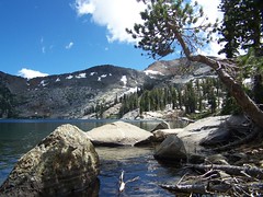
Upper Velma Lake
I had time to make it to Middle Velma Lake, at least--at this point it wasn't far off. I might have been able to make it to Lower Velma Lake as well. But I figured I would save those for a more leisurely trip into the area with my friend Erik in the future. Instead, I headed back.
I came down to a creek crossing I had a little difficulty with the year before, but flew across this time. Then I started climbing. I didn't remember the climb back from here as being so long or as having so much elevation to gain from last year's experience. Of course, I hadn't tired myself out with that much climbing prior to the return last year.
By the time I got to the junction that splits the Bayview Trail from the trail to Eagle Lake, I was worn out. It was almost all downhill from there, but my knees and feet had had enough, and I had to be careful on the way down to use my tired muscles rather than punish my tendons and ligaments further. I started counting down the distance I had remaining: Eagle Lake meant 1 mile remained. The Desolation Wilderness sign meant 1500 feet remained. Eagle Falls meant only 1000 feet to go.

On the Descent
I stopped at Eagle Falls, now entirely in shade, to get a long exposure using a neutral density filter and my Gorillapod. Finally, I made it back to the now nearly empty parking lot, still with plenty of time to get over the mountains before it got dark.
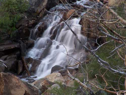
Eagle Falls
Hike Summary
Date: 19 July 2007
Trailhead: Eagle Falls
Approximate distance: 11.5 miles
No comments:
Post a Comment