
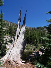
Ellis Lake
Part of the adventure of this hike was just finding the trailhead. My friend Eric and I drove east on I-80 to Truckee, then headed south to Tahoe City on CA-89. In Tahoe City we turned right at the light to continue following CA-89 down the west shore of Lake Tahoe. It's a beautiful drive, with views of the mountains and Donner Lake from I-80, views of the Truckee River and people rafting down it down CA-89 to Tahoe City, and then views of Lake Tahoe farther down.
We were looking for Barker Pass Road, to take to the parking lot and trailhead at Barker Pass. But we never did see any sign visible from CA-89 for that road. After going past it a couple of times, we checked the map yet again. Erik recognized the Kaspian picnic area right near the road as something he had seen a sign for, and we were able to find the road based on that. I believe the sign we could see from CA-89 also said Blackwood Canyon. But it was only after turning onto the road that we were able to see a National Forest Service sign that indicated it was Barker Pass Road.
At one point the road splits, with a dirt road continuing ahead directly east, and the paved road curving around south, crossing a creek, and then heading east again. A sign right in between them unhelpfully told us "Barker Pass Rd." We tried the paved road, then the dirt road, and then returned to the paved road.
The paved road was the right choice. As soon as the pavement ends, you are at the trailhead. There is an area to park up and to the left. There are no facilities.
We headed up the trail through the forest, and were immediately panting. This is a short hike with moderate elevation gain overall, but the climbing portions follow a steep grade that forced us to go slowly and work for good footing.
We climbed through forest until coming out onto an open ridge with many wildflowers. To the west were dramatic views of granite slopes and peaks and a large lake, which from the map I would guess was Hell Hole Reservoir. To the east were jagged cliffs and portions of Lake Tahoe visible in the distance. Unfortunately, the haze made for poor photo opportunities. We could see a large plume of smoke rising over in Nevada, which I assume was responsible for the haze.
The grade on this ridge was easier than that through the forested portion, though we were buffeted by winds that had me holding my hat on. After a while the ridge widened out, and we started and easy descent, which became much steeper when we started to reenter forest.
Once the steep portion of the descent was over, we had an easy stretch, with only slight ups and downs. Towards the end was a small path leading to the left, which we walked past. Soon after we hit a 4WD road with a sign propped against a tree indicating that down it to the left was Ellis Lake, straight ahead on the trail was Ellis Peak, and there was no indication of where the road went to the right.
We went straight ahead and started another steep climb on a trail not shown on my map. It came out at a 4WD road. We headed up it to the left to its end, where it does a small loop for vehicles to turn around. From there California Hiking (2001-2002 edition) said that we should see the peak plainly visible. But I knew from Kevin Gong's hiking website that this is a false summit, and the true one lies beyond it (and I should have told Erik that earlier, as I was ahead of him at this point). What I didn't know is that there is a clear trail that leads to the true summit on the east side of the ridge with great views of Lake Tahoe. I didn't spot the cairn indicating where it started.
Instead, I climbed up to the false summit, then climbed down to start back up the true summit. About midway I ran into the trail. Up at the summit, I had fantastic views of most all of Lake Tahoe, from the north end to the south end. It was also windy again, so much so that I took my hat off and put in in my backpack.
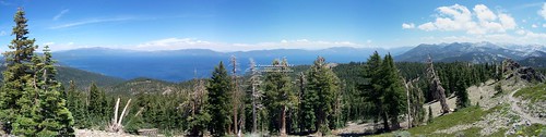
Panorama of Lake Tahoe
(To see this image in a larger size, click on it to be taken to its Flickr page, and from there click on "All Sizes")
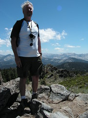
Me on Top of Ellis Peak
I stayed standing in the wind until I was sure Erik saw me, and was headed my way, then I dropped down to get out of the wind and eat lunch. Erik joined me, and after we were finished eating we took photos of Lake Tahoe and of Ellis Lake, which lies directly below the peak.
Then we started back on the clear trail, and took it all the way to the 4WD road this time. There was a cairn there, easy to miss a ways off road. To make it easier for future hikers to find, I lined up two separated rows of large rocks heading towards the cairn from the road to indicate the trail.
Then we headed down, leaving the 4WD road where a cairn marked the trail. We went down to the other 4WD road, the one signed for Ellis Lake. On my map, it looked like it was about 1/4 mile away. But California Hiking says that it is only 50 yards off on a short spur, and doesn't mention this 4WD road. After visiting the lovely lake and returning, we were able to piece it together. That trail we passed near the 4WD road on the way out goes about 50 yards to a depression with a small pond at the bottom of it. In a wet year, and/or earlier in the season, there might be enough water there for it to be confused with the lake. One could easily have seen it was not the lake from the true summit, but if you stopped at the false summit, you might not have seen Ellis Lake from above.
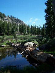
At Ellis Lake
Anyhow, I'm glad we figured things out, because we both really enjoyed Ellis Lake, and walked completely around it. Ellis Peak rises directly up from the edge of the lake with sheer cliffs. I jokingly asked Erik if he would like to return to the summit, the short way.
After we returned on the 4WD road to the trail, we had the easy stretch to complete before starting the only real climb on the return. I often push myself while hiking, but we had plenty of time, despite our delay in getting to the trailhead, so I forced myself to go at a slow pace and avoid working up much of a sweat. Once headed back down the steep portion near the trailhead, I could feel it in my knees.
I met a couple just heading up the trail here, who asked if it was a long ways. I asked where they were headed. The man told me that they were told the trail just ended after a ways (I guess it does at Ellis Peak). I told them about the two destinations. I encounter people like this often, who just hike until they feel tired enough to return, not having any idea what lies ahead, what they might be missing, or what they would need to do to be prepared to get there. Nothing wrong with that, I suppose, but I don't think it will ever be my approach.
Hike Summary
Date: 17 July 2007
Approximate distance: 6.5 miles
Links: Kevin Gong's hike report
1 comment:
Love the lake photos. Including the logs like you do makes it. I'll have to remember that next time I'm out in the woods with my camera.
Post a Comment