Erik and Winnemucca Lake
This entry covers three different hikes, one to Winnemucca Lake in 2003 when I was terribly out of shape and knew little of hiking, and just looking for some photo opportunities, one to both Winnemucca Lake and Round Top Lake in 2006 when I was in better shape and just really getting into hiking, and one in 2007, when I was ready for new challenges.
All three times the hike started from the day use area at Woods Lake. This is a splendid lake at 8210 feet surrounded by forest that you can drive right up to on paved roads. There is a campground there, and a parking area for day users. The lake is slightly to the south of the are covered in my hike to Showers Lake--about 100 miles away from Sacramento, mostly to the east.
In 2003, I chose the hike to Winnemucca Lake out of California Hiking as it was only listed at 3 miles round-trip, and as difficulty level 2 of 5, and it was supposed to have great wildflower displays late in summer. I thought this was an easy chance for photo opportunities.
But "easy" is obviously a relative term. I wasn't in shape, I didn't know how to pace myself, and the hike is at high elevation. I was panting for breath on most of the climb, and stopping frequently. I remember a couple of women 25-30 years older than me passing me.
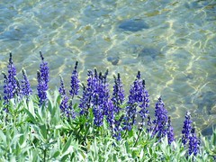
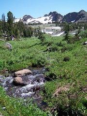
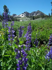
But the wildflower displays didn't disappoint. After crossing a creek on a bridge at the trailhead, the trail rises through forest and passes an old arrastra. Eventually I left the trees and found myself climbing a treeless area of mountainside with creek just below and wildflowers all over both sides of the trail.
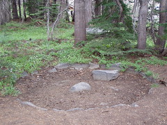
Arrastra
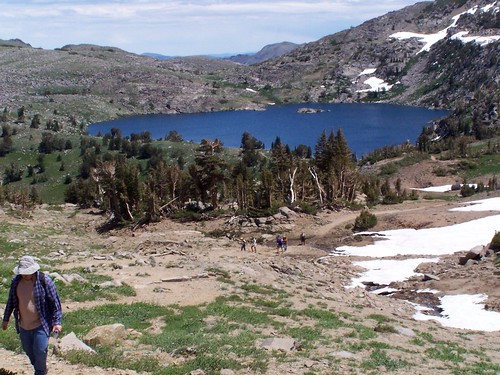
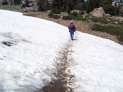
Trail to Winnemucca Lake

Red Columbine
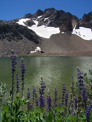
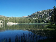
At the top, I arrived at the western edge of Winnemucca Lake, which still had plenty of snow around it. And that's about all I can remember of that hike.
In 2006, I went back with my friend Erik, only with the plan to make it a bit longer and more interesting hike by doing a loop that included Round Top Lake. We made the ascent to Winnemucca Lake, and passed a woman and a heavy set man who kept having to stop and was breathing heavily. It made me think of what I looked like hiking the trail three years earlier.
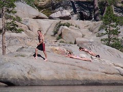
I must have gone in the middle of the week in 2003, as I don't recall the shores of the lake being nearly so crowded as they were in 2006. There are several different trails that access this beautiful area, and it is quite popular. At the lake some guy went for a brief swim (I don't think Winnemucca Lake ever gets warm enough for swimming). We went over to the northeast end of the lake, and much of the shore was marked as being off limits for restoration, as there has simply been too much traffic here. Of course, there were people ignoring the signs.
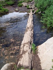
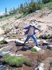
We headed back to the west end of the lake and had to cross the outlet creek to proceed to Round Top Lake. Erik had no problem crossing the log. I started to slip off and just had to rush on and jump to the other side.
Where I Almost Got Wet
We started a climb up from Winnemucca Lake with nice views of it when we turned back. At one point the trail was still covered with snow, which was quite nice to see, considering the extreme heat wave we were experiencing in Sacramento at the time.
Snowy Trail
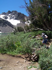
Rock Hopping
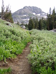
After the climb the trail made a slight descent along a narrow, but well worn, path to Round Top Lake. The shores here were also crowded, with both hikers and llamas. We continued around to the south end of the lake to eat lunch.
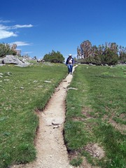
Well Worn Trail
Edge of Round Top Lake
Afterwards we started our descent to Woods Lake. We passed through a great variety of beautiful settings, through forest, granitic areas, by creeks, and past a lush meadow. We came to some ruins of an old vehicle and who knows what else, and I believe it is here we probably mistook our trail, going along the creek to the left of the ruins, rather than to the right.
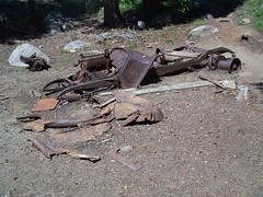
Old Car
We were soon clearly off trail, and just started working out way down to Woods Lake via whatever looked like the easiest way to go. I started taking a series of overgrown switchbacks, with Erik following. They were too regular to be accidental, and too overgrown to be the designated trail. We surmised that we were on an abandoned trail.
We met up with what seemed to be a clear trail and came up to a creek crossing with just a big log to get across. I didn't much like the idea of crossing there, and started down again cross country. But in talking to Erik, he said he had seen trail on the other side, so I climbed back up. Who knows if the creek could be crossed down at the level of the lake.
It was a wider log than the one we had crossed up by Winnemucca Lake, but I still needed the help of overhanging branches I could grab onto for balance. Once on the other side of the creek, we were on clear trail again and finished our descent. We came out in the campground by Woods Lake, and worked our way through it back to the parking area for day use. We checked out the shore of Woods Lake before getting in the car and heading out.
Back at Woods Lake
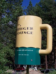
We made a detour on the way home to go into South Lake Tahoe and eat at Burger Lounge. I had the Black & Blue Burger (with blue cheese), and Erik had some vegetarian excuse for a burger.
Erik and I returned again in 2007, the day after we were placed on involuntary vacation when our employer ran out of work for us. This time we started up towards Round Top Lake first, for some variety. If you are heading into the campground from the day use area to find the trail to Round Top, you can get to it via a use trail next to the sign for camping spot #11. But if you park at the Wood Lakes Trailhead area, I think you will find a sign for it there, as we reached a sign pointing one way for Round Top Lake, and another for the parking area.
There was no mistaking our path this time. There is another path up, but it is marked with "No Trail" and warning signs about entering an active mining claim area. We saw the mine down below the trail, with a big "KEEP OUT" on it. We got to the log crossing, which was easier for me this time, as the water flow was down. We passed the ruins and discussed where we went wrong last time.
We passed through some gorgeous scenery once again, but I was disappointed not to be able to get a shot in better lighting of a meadow with Black Butte in the distance to the west. I guess when we passed it last time, it was when we were on the wrong trail.
The Sisters loomed up ahead, the peaks that rise up directly from Round Top Lake. In no time at all, we were at the lake. I called back to Erik, "That was too easy!" There weren't nearly so many people around the lake this time.
Round Top Lake
Erik Crossing the Outlet Creek
After exploring some photo opportunities, we headed back to the trail junction, and then went across the north shore of the lake to start up the unofficial use trail to the summit of Round Top.
After reading about it in one of my hiking books the year before, I had avoided this. But then I joined the Sacramento Hiking Meetup Group. I've sill never made it on a hike with them, but I attended one planning meeting. The leader of the group talked about this particular hike, and how even as a beginning hiker she found it easy, although, as she said, she had to come down from the summit on her butt.
So we started up. At points there were multiple paths, usually one heading directly up, and another taking more of a switchback route. I chose the switchback route whenever possible, so that the footing was more secure. It was steep, but pretty safe, up until the final ascent. Then the path became unclear, and I was using my hands as well as my feet to climb the side of this mountain. I met a couple descending, and asked them if was worth the effort. They told me yes, and said there was a crowd at the summit (6 people).
Just Below the Summit
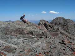
Finally, I got right up below the summit, but one of the guys hanging out there said, "You're not there yet!" It was only about 4 feet higher to the very top, but the footing was uncertain, and the drop-off was unnerving. I made it up and just sat down. I didn't feel comfortable standing. I sat and ate my bean and cheese burrito. There were great photo opportunities, and I thought I should record a video by turning in a circle to give a panoramic view of the setting, but I didn't do that or take much for photos.
As it turns out, this was not the true summit, which is actually just a few feet higher to the east, but requires you to go down and back up a steep-sided cleft, which "separates the brave from the wise," according to Tahoe Sierra. One man chose to be brave, and I watched him with some anxiety trying to return to where we were, hoping that I wouldn't see him plummet to his death. He did, after a good long time, make it back safely.
When the group that was there got up to go, I started following them, thinking that Erik might have abandoned the climb far below, and that it would be handy to be able to follow other people down. But Erik arrived about that time, and, of course, he deserved to experience the reward for that effort. While he rested, ate, and took pictures, I went just a little ways down to an area where a rock wall had been piled up as a windbreak, and hung out there, as it was awfully windy. This was also a beautiful, but more secure feeling, area.
Me on the False Summit
Erik came down and we took some photos of each other up on top of the world. As we started down, a young boy and a man he called grandpa came up. The boy asked me if it was safe up where I was, and if there was a trail. I told him it was safe where I was, but it got a bit precarious beyond that, and I hadn't seen much of a trail, I just climbed the side of the mountain.
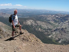
Erik's Photo of Me

My Photo of Erik
There is only one point at which there are cairns to indicate any sort of a path. We descended to that, and rather than going back how I had come up, I suggested to Erik that it looked like the other side was a bit easier. I started down, but we came to a point that made Erik uncomfortable, so it seemed safest just to go back the way we had ascended. I panted up back to Erik and past, and descended the way I had come up.
The descent was actually easier than I expected. I did inadvertently kick a big rock on the way down that went tumbling a long ways, and I just hoped it didn't hit anyone ascending. I sat down a couple of times to get down larger gaps, but it wasn't too bad. I got to a point where I could follow a switchback pattern that was pretty easy. Erik chose a more difficult and direct route down, as did the grandfather and grandson following him, as did the three guys hiking up the other direction. My route was definitely easier.
At the base of the extreme portion I waited for Erik, and saw a woman taking photos. She came up all this way, but was not going to make the final ascent. Since she was only wearing tennis shoes, that was probably for the best.
Then I started down to Round Top Lake. I went pretty quickly. It was steep, and the rock was loose, but by doing a zig-zag pattern on the trail with my feet at an angle to the grade I had secure footing and made good time. Down at the lake, I saw a guy with skis and ski boots strapped to his back. Farther on I could look up and see the path he had cut through the snow above Round Top Lake.
We started the slight ascent from Round Top Lake before making an easy descent to Winnemucca Lake with dramatic views. The sky was somewhat hazy in that direction, however. This time, there was no snow on the trail.
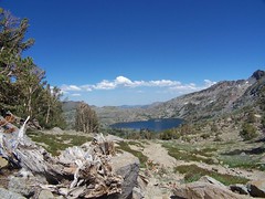
Winnemucca Lake
Down at Winnemucca Lake, I had to cross that log I had barely made it across the previous time. This time, however, I was going the opposite direction, starting on the narrow end, and moving towards the wide end. On the other side I set up to film Erik making the crossing.
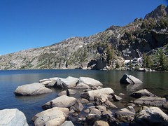
Winnemucca Lake
We then made the short and easy descent back to Woods Lake. Climbing to the summit of Round Top made this a 2,171 foot climb, but it was still pretty short in distance, at only 6.4 miles.
Back at Woods Lake
Hike Summary
Dates: 30 July 2003, 30 July 2006, 13 July 2007
Trailhead: Woods Lake
Approximate distances: 2.8, 4.4, & 6.4 miles
Links: Kevin Gong's hike report
No comments:
Post a Comment