At this point, I've made this hike three times, so I'll be drawing from all of them for this description.
One of the most appealing features of this trail is how easy it is to get to from Sacramento. It's just off of I-80 at the Big Ben exit (eastbound), on the frontage road that was US 40. The drawback is that the quick and easy access makes this trail quite popular. The authors of California Hiking warn that it can be crowded. I believe it was especially so one Saturday in 2006 when both the local Sierra Club chapter and the Sacramento Hikers group on meetup.com had hikes planned for this trail on the same day. There's a visitor center just before the small parking area, and I've read that there are wagon tracks visible from the emigrant caravans nearby.
In 2006, I went on a Tuesday. There were certainly more people than on most hikes I take, but I wouldn't say it was crowded. In 2007, I went on the spur of the moment on a Sunday in early June. There were more people, but probably fewer than if I had waited until later in the season. In some years you would not want to do this hike that early, but since we had such a dry winter, it wasn't a problem. I did it a week later in 2008, and it was pretty crowded.
Since the trailhead is so close to the freeway, you can unfortunately hear the traffic for much of your climb. The first part of it is over exposed granite, and it is easy to lose the trail. People go all different ways and sometimes leave cairns. You may think you are following the trail, only to meet up with the most heavily used trail later on, and realize that you were on an alternate route. It really doesn't make too much difference. Right near the very beginning is the steepest portion of the trail, but it is also very brief.
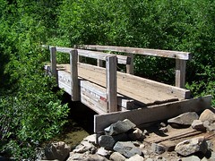
You descend into a swampy area with some nice lily pads in some trees before coming out onto the rocks again. In 2006, there were lots of mosquitoes here, but I didn't notice any in 2007 or 2008. You head down a bit and see a stream below the trail. On my 2008 hike, I saw some people chose to just hang out here. It's a nice spot, but you can still hear the traffic on I-80. Later there is a bridge crossing the stream, and then an easy climb through a pleasantly shaded area before you suddenly come out in the open at railroad tracks.
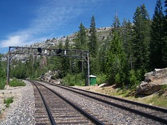
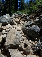
Once you have crossed those, the most strenuous part of the hike begins. You head up switchbacks on a very rocky trail. In 2006, I was really surprised by the difficulty I had, as the book had made it sound much easier. In better shape in 2007, I still got short of breath, but found the steep portion to be not that long compared to other hikes I have done. I did wonder about all the hikers I saw with dogs, as I would think the rockiness of this trail would be bad for their paws. In 2008, I had no trouble at all. I'm pleased that I'm still improving in my hiking abilities, even though my waistline is headed the opposite direction.
When you reach the end of the switchbacks, there are some dramatic views off trail to the west. Many people have climbed over the wall of rocks placed to indicate the trail to check out that view, and I did all three times.
From there it is a pretty easy hike to Upper Loch Leven Lake. Don't ask me why they stick on "lake" in the name when it already has loch in it, or why there are Upper and High Loch Lakes and a Middle Loch Lake but no Lower or Low Loch Lake. There are campsites and fire pits around here, and use trails around the lake. But it's pretty easy to find the trail on to Middle Loch Leven Lake.
You descend before ascending again to Middle Loch Leven Lake. There's one portion I didn't like in 2006, and I found an alternate route. I saw in 2007 that many people have gone the alternate way, but I had no problem with the main trail that year. It's just a big rock with a steep slope you have to climb down. In 2008, I went back to the alternate route.
It seems that most people who make this hike stop at one of the first two lakes. I intended to reach the third one, High Loch Leven Lake each time I went. I didn't make it in 2006, however.
The trail becomes harder to follow after Middle Loch Leven Lake. There are occasionally spots of orange spray paint on boulders to indicate the way, and, of course, cairns. I've found, however, that some people just head off their own way and leave cairns, so they don't always indicate the trail.
In 2006, I followed what I was pretty sure was trail until I hit a dead end. There were large rocks to the left of me, so I climbed them and found a pool of water. I figured it must be High Loch Leven Lake, so I stopped and ate my sandwich before heading back. Later, looking at my photos and a map, I decided that was most likely not the lake.
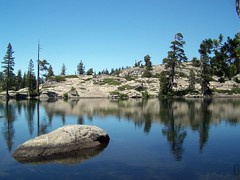
Pond
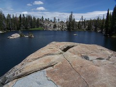
High Loch Leven Lake
In 2007, I ended up at the very same dead end. But as I was standing there thinking about the situation, a guy and his dog went by at a good clip just on the other side of a stream and a rocky ridge. So I crossed the stream and climbed over the rocks and there was a clear trail. I followed that and ended up at a lake with a sign nailed to a tree that said High Loch Leven Lake. There was still some snow that high. In 2008, when I came to the tricky area, I looked carefully. There was a swampy area that had to be crossed to the right, but it was clear that it was the trail because you could see where logs on both sides had been cleanly sawed off in order to remove the obstruction on the trail. Otherwise, it was still difficult to recognize as trail.

Snow!
There's some more climbing before you reach High Loch Leven Lake. Once you get there, if you want to go down the south shore (right, as you approach it) early in the season, you have to cross a pool of water. I think I followed a couple on a narrow log in 2007, and nearly fell. In 2008 I went a little farther out of my way on some wider logs.
In 2007 I hiked to the end of the lake and around its eastern tip, looking for more photo opportunities. In 2008, I led my friend Erik on a entire circle of the lake, which involved me starting off and then coming back many times, and going a long way away from the lake to avoid a precipitous drop. But we had plenty of time--we were hiking on the longest day of the year--and I had plenty of energy (and Erik wasn't objecting).
In 2008 we ended up on a granite area on the north shore of the lake. There are two really good granite slabs to hang out on there. Both were occupied. And there were people on the south shore as well. In 2007, the only other people I saw at High Loch Leven Lake were the couple (with their dog) that showed me the way. They went swimming, which I thought was crazy while there was snow just a few feet away from the lake. In 2008, I went swimming out to a granite island. It was cold in the water, but even colder on the island, as the wind picked up.
Once we got past the tricky part of the trail on the way back in 2008, I got Erik's approval to go off trail and climb up over a ridge to the east shore of Middle Loch Leven Lake. We had seen that lake coming down from High Loch Leven Lake, and I had seen a boy wandering on the top of the ridge, so I was pretty sure climbing over it would get us there, and it did. We then followed a use trail back to the main trail, which we followed the rest of the way out.
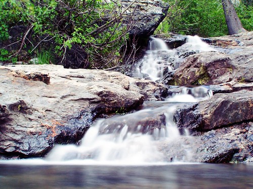
On the return trip in 2007, I made another off-trail excursion near the end of the hike at a stream to get some long-exposure shots of whitewater just below the bridge in the earlier photograph.
Hike Report
Dates: 18 July 2006, 10 June 2007, & 21 June 2008
Approximate distances: 7 miles & 7.8 miles
Trail head: Loch Leven Trail
4 comments:
I like the Pond photo better than the actual lake, because of the reflection. Sometimes it isn't such a bad thing to take a wrong turn.
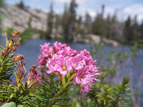
Another of your wildflower photos from this trip gave me goosebumps when I first saw it on your flickr page.
Hey, next time keep going east after High Loch Leven east along the ridge, and you will come to Fisher lake. Few people go there because there is no trail, and there are cool views to the south over a valley to Snow peak, I believe its called. If you are really feeling energetic, go cross country south to this peak to see an incredible deep canyon just south. Very wild country. Stay overnight at Fisher to make it an easier trip.
Try to look for the answer to your question in google.com
Great readiing
Post a Comment