(I originally wrote this as an article for Midtown Monthly, a Sacramento publication. It appeared in the October 2009 edition on pages 34-36.)
Just 40 miles north of Sacramento lies the historical treasure of California's Oldest Little City (as it is nicknamed), Marysville. I was first drawn to the city after reading an article in 2000 about its endangered historic cemetery and the efforts to preserve it. Upon making my first of many visits, I found that the city much resembled its venerable cemetery. Both are rich in history and both have benefited from hard efforts to preserve that history. But given the challenge the people of Marysville are faced with, much of that history is also suffering from neglect, and being lost.
Marysville, also known as the Prune Capital of the World (with its sister across the Feather River, Yuba City), was one of the largest cities in California during the Gold Rush, and could boast of having just the second courthouse in the state. It was booming through the 1940s, but the coming of California car culture was a major blow to the city. One reason for this is the geography of the area: Marysville's growth is constrained by the Yuba and Feather rivers, and the high levees that protect it from flooding. When residents moved out of the central city to the suburbs after World War II, as happened in all urban areas in California, they moved to Yuba City, Linda, and Olivehurst. Businesses followed them, and left Marysville with a largely abandoned and neglected downtown and a much diminished tax base. The population there today is not much more than it was in the 1850s. It currently hovers around 12,000, while it was around 10,000 at the height of the Gold Rush.
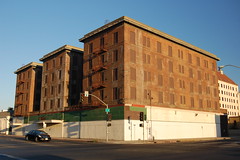
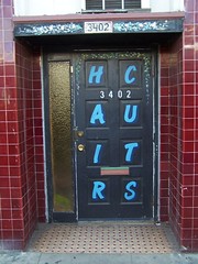
The Boarded Up Hotel Marysville
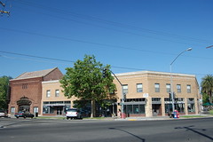
But while neglect destroys, it can also preserve. In Sacramento many historic buildings were demolished because of aggressive redevelopment in the 1950s and 1960s, made possible by the rapidly expanding state government bureaucracy. And whole city blocks came down to make way for the freeways. There has been no such wholesale destruction in Marysville. Instead, the losses have been more piecemeal, and there are enough historical treasures remaining to make it well worthy of a visit. In fact, the entire downtown area of Marysville was added to the National Register of Historic Places in 1999.
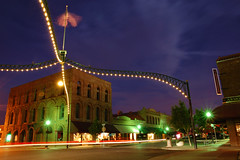
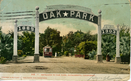
The first thing that catches the historically inclined eye in downtown Marysville is likely to be one of the four-cornered arches that span several intersections. The original arches, one of which stands today in Rio Linda, were erected for the electric trolley system in 1911, and came down in the 1920s. The contemporary replicas were installed starting in 1996. Signs for Marysville now use the eye-catching arch design as an emblem for the city.
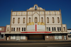
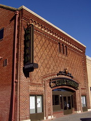
State Theatre
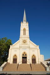
Two historic movie palaces still stand in the city, although neither operates as a theater these days. The Tower Theatre on D St. opened in 1941 (not in the 1920s, as the city's walking tour brochure erroneously states) and was designed by William B. David, who also designed the Tower Theatre and the Esquire in Sacramento, and many more Central Valley theaters. It is now used as an office building, but the original entrance and marquee have been allowed to remain. The massive (1672 seats) State Theatre was built as the National Theatre in 1927, and became the State in 1936. It still presents an imposing façade to the steady traffic along E St, California Route 70, although it sits idle. There is interest in restoring the theatre, but that seems as if it would be an impossibly expensive project for the small community.
St. Joseph's Catholic Church
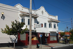
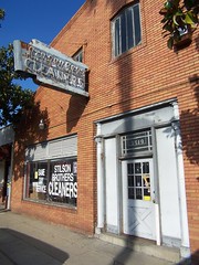
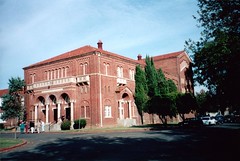
Other significant buildings downtown worth taking a look at include the old Packard Library (1906) at 4th and C (now used as a community center), St. Joseph's Catholic Church (1853) at 7th and C, the Hart Building (1926), tallest in the county at 7 stories on 4th, and the boarded-up Marysville Hotel (1927) on 5th. A bit north of the downtown area, the Romanesque Marysville High School building is one of the most impressive buildings in the city.
Marysville High School
Among the residential neighborhoods there are many fine examples of Victorian architecture, most notably the fanciful house at 222 5th St. known as the Castle (1851), and the Mary Aaron Museum (open by appointment), finished as a house in 1856 at 704 D St. The Mary Aaron Museum actually looks more like a castle to me than the Castle does. One book describes it as "the most fanciful surviving example of the Gothic Revival in California." The museum's collection focuses on the daily lives of local residents from the past. There are also supposed to be seven houses designed by famed architect Julia Morgan (who designed the public market building now used as part of the Sheraton Grand in Sacramento) in the city, although I've only found two so far, both on the 700 block of F St.
Portal to the Bok Kai Temple
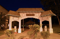
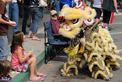
The best time to visit the city is the first Saturday of the month. That's when the real gem of Marysville, the Bok Kai Temple, is open to the public, as is the Chinese Museum of Northern California, from noon to four (both free admission). The main temple room has only recently reopened after being closed for a year for restoration, which uncovered two beautiful murals. Each year the membership of the temple put on the Bok Kai Festival, which features a parade with a large Chinese dragon. The festival will take place March 20-21 in 2010. The small Chinese Museum features the remains of the Sanfow Bean Sprout Plant in the back and is quite thorough in presenting the history of Chinese immigration and settlement in America. Nearby stand two buildings with elaborate façades from the once more extensive Chinese enclave.
Bok Kai Festival Parade
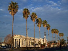
If you have time to visit Yuba City across the river, there are two interesting historical areas to peruse. The oldest is on 2nd St., which features the magnificent 1891 Hall of Records, the 1871 Sutter County Court House, and Red Tire Antiques, the largest antique store I have visited in the area. The main downtown area is now centered around Plumas Street, developed from the 1910s-1950s. It has undergone extensive upgrades in the last few years in an effort to rejuvenate the city center that appears to be succeeding, although the Sutter Theatre building is currently vacant.
If the weather is nice, you may be interested in spending some time in one of the two parks Marysville has to offer that would do a much larger city proud. The park area around Ellis Lake should remind Sacramento visitors of William Land Park, as the lake much resembles the water features of our beloved park. Described by the Chamber of Commerce as the "jewel" of Marysville, Ellis Lake was created from an area of swampy land, and was completed in 1939. Bryant Field, where the Yuba-Sutter Gold Sox baseball team plays, sits close to the lake. And spanning a good stretch of the shore of the Feather and Yuba rivers and their confluence is the massive Riverfront Park Complex, featuring fishing, picnic areas, soccer fields, a motocross track, and more. Spanning the Feather River, and best seen from this park, is the historic Northern Electric Railway bridge, ca. 1911-1913. Later Northern Electric became part of the Sacramento Northern Railway, which offered interurban service throughout the area.
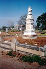
Marysville Cemetery
And, of course, there is the cemetery that drew me to Marysville in the first place. Unlike when I visited 9 years ago, the cemetery is now only open by appointment. But I recently found the gate open on a Friday morning, as a caretaker was at work, and slipped in to take some photos. I'm sure much work has been done at the cemetery in the last 9 years, but it still looked much as I remembered it from 2000, with many monuments standing, while others crumble on the ground. And everywhere to be looked there were indicators of the never-ending battle to preserve the city's heritage.
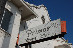
When it comes time to end your tour and sate your hunger, you can still find yourself immersed in Marysville's history. Right in front of the Bok Kai Temple is the Silver Dollar Saloon, a steak house with a beautiful 19th-century hardwood bar. The building, constructed in 1858, once had a brothel on the second floor. The restaurant makes a nod to its past with memorabilia on display from the famous Mustang Ranch in Nevada. Hundreds of silver dollars are embedded in the surface of the bar, and the interior is decorated with rustic wood, historic artifacts and farm implements, and Victorian lamps. The atmosphere is charming, and the food is quite reasonably priced.
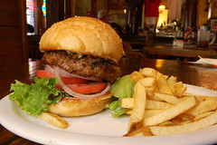
Silver Dollar Burger
Walking D St. in downtown Marysville, once the main drag before a new bridge across the Yuba River shifted it to E St. in the 1950s, you can see photos placed in a few vacant storefronts of historic structures the city has lost, like the grand old Yuba County Courthouse, demolished for the sake of modernization in the 1950s. While it is sad to think that people willfully destroyed such magnificent pieces of their history, it's also a nice reminder to appreciate what we do have while we can still enjoy it. One of those things to appreciate is right on Sacramento's doorstep--Marysville, California's Oldest Little City.