Above Arch Rock
My friend Erik and I wanted to go hiking at Point Reyes National Seashore sometime this week. He suggested Tuesday, but the forecast for Olema suggested that was the day of the week with the most rain. I chose Thursday, when there was just a chance of showers. And I decided we would just start out on Bear Valley Trail, and take some route that would take us across Woodward Valley Trail, which I enjoyed a lot on my own last year. The tides were all wrong for any visits to the shore this week.
We ended up hiking in the rain all day, and never made it onto Woodward Valley Trail
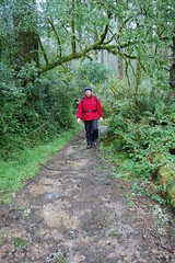
I picked up Erik at 7:45 and we headed down a route I drove just from visual memory: I-80 to Vallejo, CA 37 to US 101 North, exit at what turned out to be San Marin Drive (which I just recognized from a building on the hillside), west to a school, then right on Novato Boulevard, north to Point Reyes-Petaluma Road, west to a stop sign at a bridge, right to CA 1 at the north end of Point Reyes Station, then south to the turn off for Point Reyes, and finally the turn off for the visitor center and the Bear Valley Trailhead. It took about 2 hours and 20 minutes, given that we were coming from the northeastern suburbs of Sacramento, and had to drive through downtown in rush hour.
We decided to hike Bear Valley Trail to Old Pine Trail, veer off there to go to Sky Trail, then take a short jaunt over to Woodward Valley Trail, take it down to Coast Trail, and then head back to Arch Rock and the end of Bear Valley Trail to take that trail all the way back to the car.
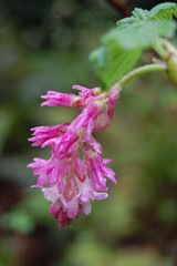
The first two legs worked out. We headed along the easy and wide Bear Valley Trail (it's a road), with a steady rain on us. A creek flows alongside most of the trail. Frequently fallen trees span the creek, and have ferns and moss growing on them. All around the trees lacking their leaves were fully covered by other green plant life. Plenty of milkmaids (small, white wildflowers) grew off the side of the trail.
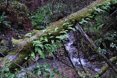
Along Bear Valley Trail
In what seemed like very little time, we reached Divide Meadow, where there are pit toilets, and the junction with Old Pine Trail. On that narrow trail, we started climbing through the forest. There was at least one clearing along the trail, and a couple of points where we were on the edge of a hillside, and could look down on banks of fog. I stopped to take a photograph of some witch's butter, with my camera protected by a plastic freezer bag. We were keeping our cameras underneath our jackets while we hiked.
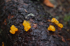
Witch's Butter
Shortly after that photo stop, the rain let up. It was still drizzling a bit, and the saturated trees were dripping, but it was drier overall. After reaching the top of our climb, we made a short descent to Sky Trail.
Erik Arriving at Sky Trail
There were plenty of signs there, with arrows, trail names, and exact distances. I thought I knew where I was going well enough--just a short jog towards the coast to Woodward Valley Trail, so I didn't check the signs. Erik did, and was confused, because the sign indicated that Woodward Valley Trail was the opposite direction. But he trusted me, and followed along.
Along Sky Trail
I could tell we were going too far, and getting too close to the coast, and not heading over in the direction that I remembered Woodward Valley Trail as being. Erik then mentioned the sign, and I checked my map, and indeed we were going the wrong direction. But we kept going, since we had gone so far already, and just headed down to Coast Trail from there. There were great views, that just don't translate into photographs, of the shore and Point Reyes in the distance, coming down the last portion of Sky Trail.
Just before reaching Coast Trail, we took stock of the situation. We could head north on the Coast Trail to Woodward Valley Trail, and head back on it. This would make it a very long hike, with quite a bit more climbing. Or we could just head south to Arch Rock and head back to the car on the easy Bear Valley Trail. The voice of reason told me that we should go the easier way and take our time taking pictures, rather than try to make up for my blunder.
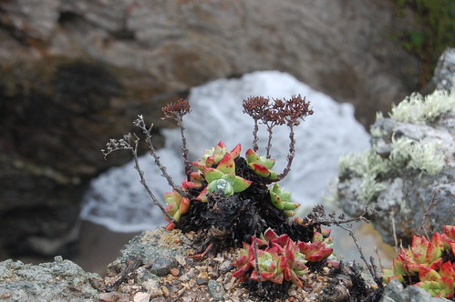
Ice Plant Above Arch Rock
And that's what we did. Along the way, we saw a variety of wildflowers--ice plant, monkey flower, Douglas iris, and others. Down at Arch Rock, we took the unofficial trail down to the creek--an unofficial trail that has crumbled quite a bit since we last hiked it. Unlike last time, the creek was too swollen from rain for us to make a comfortable crossing.
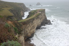
Arch Rock
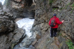
Erik Thinking About Crossing
Instead, we headed back farther south along the coast trail, crossing the creek the easy way, on a bridge, and then worked our way over to the cliff across the creek from Arch Rock on the south. There we had nice views of the arch that gives the outcropping its name. It looks like people climb down from there, with the only difficulty being the chance of the cliff crumbling beneath you. We decided there wasn't enough reward for the risk--we had already been down there last year, and the tide was too high to explore the beach at all. Honestly, it was the rational decision--it's not because we're wusses.
From there we headed back on easy and wide Bear Valley Trail. As we got close to Divide Meadow, the rain picked up again. After that, we encountered an interesting bird. I get highly frustrated trying to photograph birds, as they don't let me get anywhere close. To compound the difficulties, it was dark, and I didn't have a good telephoto lens. But the bird let us get surprisingly close. In fact, I'm sure we could have gotten closer. But when we got to a certain point, we were concerned that the bird must be injured, or else it would have taken off. We chose not to stress it further, and left it alone.
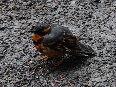
Poor Birdy
From there it was an uneventful trip back to the car, a quick stop at the Cheese Factory on the way back, and a mercifully easy trip back to Sacramento, considering how close to rush hour it was.
No comments:
Post a Comment