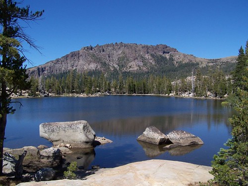
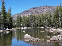
Granite Lake
So far I haven't been going on overnight trips to hike, but just driving up in the morning, doing a day hike, and then driving home in the evening. That means a lot of miles, which means a lot of wear on my car, a lot of money spent on gasoline, a lot of fossil fuels burned (although I do drive a Metro), and a lot of pollution released into the air, all so I can enjoy pristine natural areas.
To avoid that I have purchased a tent so that I can squeeze more into a single trip in two days, and then not have to travel as often. And I have been looking for closer hikes in the mountains that are still long enough to give me a good workout and get to beautiful places. I've nearly exhausted the nearby ones in my hiking books, and am already repeating hikes frequently.
With that in mind, I studied nearby areas on the old topographic maps used in the National Geographic Topo! software to see if I could come up with such a hike. I decided it looked like I could park at Allen Camp, hike along the shore of Silver Lake up to Granite Lake, then on to Hidden Lake, and then drop back down to Allen Camp, a little under 6 miles total, with less than 1000 feet of elevation gain, and three lakes.
I had to cancel a planned camping trip on a Sunday to take care of some annoying business Monday morning, so when I was done with that, I decided to squeeze in this hike. I didn't make it on the road to Silver Lake until 11:30.
Silver Lake is about 70-75 miles east of Sacramento, as the western tanager flies, and 20-25 miles south of the west shore of Lake Tahoe, just off of CA 88. It's a large lake in the mountains that is close and easy to get to from Sacramento, so it is developed. I went towards the Plasse Resort on the south end of the lake, but there is also a resort on the north end.
I drove past the office for the resort and past campgrounds, following the sign for the Stockton Camp. Immediately after that sign I reached the sign for the USFS Allen Camp. The spots in the parking lot are all large enough for vehicles with horse trailers, and there is a corral for day use next to the trail head.
I headed east at what appeared to be the trailhead, crossed a dry creek, and encountered an trail going north-south. For the time of day to give me the lighting I wanted for each of the lakes, I had decided to head north up along the shore of Silver Lake first.
I'm not sure if this trail was what I wanted, as the whole area is filled with camp sites, and people have just walked everywhere. There were no signs indicating destination and distances. I just started heading down to the lake, and quickly found myself wandering through campgrounds, past tents, RVs, Airstreams, and 5th wheels. Eventually I got to a place where a log ahead had "campsite" written on it, and off to a side, an arrow pointed to the left. I went to the left and before long found a trail. This soon merged with another trail, then another, and another still. Eventually I got to a sign indicating Camp Minkalo, 2 1/2 miles.
The trail went alongside Silver Lake at a bit of distance. Silver Lake was quite low this late in a dry year, and much of the area that had been underwater earlier was now mud or meadow. The trail would divide often, with one portion going nearer the water, and the other staying farther away, and then they would reunite. I stuck close to the water, and wandered off trail often to look for photo opportunities.
Silver Lake usually has one large island, Treasure Island. That day it had none. The water was low enough that you could walk out on land covered with tree stumps to the island. I was out exploring along this area before going back to the trail, and I'm guessing that is what led me to miss my trail junction.
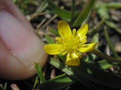
Tiny Wildflower
There were two problems at work here. I take maps along on my hikes, but I don't always study them before I march off. And my map was outdated. It did not show a trail running all the way north and south along Silver Lake. Instead, it showed the trail veering away from the lake at Treasure Island, and then coming to a junction.
A ways past Treasure Island the trail started to veer away from the lake, but then it came right back to it, and soon I was approaching the north end of the lake, which I knew was wrong for heading to Granite Lake. I passed some people having fun swimming in a cove that just looked perfect for that activity, and passed a woman sitting by the side of the trail sketching. Then I was on an all rocky area, and quickly lost the trail.
Directions for Shortsighted Hikers
At that point, I noticed a chimney to my right. Not the top of the chimney presumably attached to something unseen below, but a freestanding chimney of proper size for a house. I walked over and found and old foundation with it. Near there I saw trail, which I started to follow back south. It led me to a dirt road, and that led me to cabins that appeared to be rentals. I assumed this was Camp Minkalo. I headed down on a trail and soon saw the woman sketching, only this time I was on the other side of her. I dropped down to the trail and headed back.
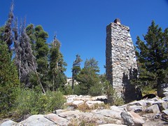
Chimney
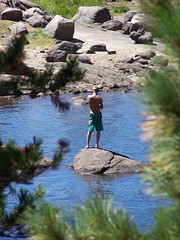
Silver Lake Swimmer
This time I was studying my map. When I got back past the tip of Treasure Island, I decided I should be off to the west. I started climbing cross country up the slope to my left, thinking maybe if I got high enough I could see Granite Lake. But as I started climbing, I ran into a trail heading northwest up the slope. Presumably I would have found the junction with it had I continued south on the trail along Silver Lake.
I climbed up this trail through forest to the northwest, then it turned back south, and soon I encountered the junction that was marked on my map, with a sign indicating the direction to Granite Lake. I headed along and soon encountered a disappointing body of water. It was filled with granite boulders, but was no more than 2 feet deep in most places, and surrounded by mud and grass. I took pictures, but was disappointed that it wasn't suitable for swimming, as I wanted to swim that day, and had passed up suitable spots in Silver Lake.
Pond
I headed out on the trail again, and soon came to Granite Lake. What I had just been at was only a pond. Granite Lake was really more than I had hoped for. It had a dramatic backdrop, great sloping granite shelfs to hang out on next to the water, and it was nice for swimming, with granite and sand below the water, rather than mud and reeds. There was a family at a peninsula sticking out into the north part of the lake, so I went to a granite shelf on the southeast shore. I took a swim, then dried out in the sun on the granite, and ate a sandwich.
When I was mostly dry, I continued on through thick forest on a dirt trail. It was comfortable to hike on, after having abused my feet on rocky Mt. Tallac Trail on my last hike. I came to another junction in the trail. For those coming from that trail from the east, there was a sign indicating Granite Lake back where I had come from and Hidden Lake on the trail ahead of me, but there was nothing indicating where that trail had come from.
I continued on and came to Hidden Lake, which also proved to be a delight. It too had a quite dramatic cliff backdrop, although it didn't look as nice for swimming, and I would guess that earlier in the season there are lots of mosquitoes there. It was muddy along the shore, and there were grasses growing up to and into the water on the opposite shore. I had Hidden Lake to myself, appropriately enough.
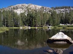
Hidden Lake

Hidden Lake Reflection Upside-Down
My map showed the trail heading southeast of Hidden Lake before curving around to the east and then the north and returning to Allen Camp. There was a sign by the lake saying Plasse and pointing towards the south, which I took to be Plasse Resort, but it said 3 miles. That was puzzling, as I figured the whole hike was less than 6 miles, and I was about 2/3 of the way through it, it appeared when I glanced at the map. But I started out anyhow.
To my surprise, I started climbing, and climbing more, and I was doing more climbing than I had done on the rest of the trail. As I was about to start up some switchbacks, I reconsidered. If this was a 3-mile dead end, it would turn into a 6-mile mistake. It seemed as if I was headed up to the top of the rock formation, and I thought maybe this was Plasse, from which the resort took its name. I decided to head back to that junction with a trail between Granite and Hidden Lakes, the junction and trail not shown on my map, and take that trail. It was headed the right direction. Ultimately, I wasn't that far from Silver Lake and its campgrounds, and I could always just head down cross country if necessary.
But that wasn't necessary, as this was a trail that headed down to the resort area. It soon merged with another trail coming from the southwest. At that point I was wondering if that was the trail I had wanted to be on, and if they sold a trail map of the local area at the resort. It wasn't too long before I spotted a tent and and RV, and came across a trail running north-south along a large, dry creek bed.
I started south on that, but started climbing away from road, so I just set off to the east to get back to the road. Only then I encountered an area of enormous granite boulders that I had to climb and hop across. And as I got farther across it, bushes growing between them made the passing more difficult. I headed back north a little ways where ferns, rather than bushes were growing between the boulders, and came out on a trail next to a dry creek bed, just about 50 feet from the Allen Camp horse corral.
I had a few problems on this hike, but they are the kind I don't mind dealing with, and I ended up in a much better mood than I had been in all morning. As I drove up to CA 88, I was struck by the lighting of Silver Lake and the volcanic cliffs behind it, and pulled off the road to take another couple of shots before returning home.
Date: 20 August 2007
Trailhead: Allen Camp
8 comments:
Did I miss something? You started by saying something about camping and a tent. But it seems that this was another 1-day hike. ???
How did you take these photos?
-camera make & model?
-settings?
-time of day?
-special filters/lens?
-photoshop?
You can click on the photo to go to the Flickr page for it. If the photo hasn't been edited in any way, you can click on the camera info and get the camera, the camera settings, and the time of the photo.
The only photo I did any editing other than cropping on was the upside down shot, which I rotated a bit. But even if I just did a minor crop on the photo, it would strip the exif information, as I have old software.
I had a polarizing filter and a wide-angle conversion lens with me. I don't recall when I used them and when I did not, however.
Hi My name is Connie Yesterday my husband and I went to Silver Lake. I was a camp counselor there in the mid 60's. That chimney is what is left of the
" Senior" oldest campers lodge. It was the biggiest and the best and the girls could hardly wait to get there. I worked with them one summer. I don't know what happepned to the camp but the dinning hall and lodge were gone and they were substancial buildings. There were at least six areas with different agae groups I only found one building still standing. All I could say was wow wow wow everywhere we walked.
So Beautiful...
I worked as a dishwasher for 2 years in the late 60's (67 & 68 I believe) when this was a Campfire Girl Camp.
Larry
I was a Camp Fire Girl at Minkalo in the late 70's. The ridged peak in the earliest photo we called "Thunder mountain" we thought he looked like a huge dragon (his head is on the far right of the photo and the caves are his eyes and mouth). The old chimney was part of "senior lodge" which would have been the first lodge after the dining hall on your way into the camp. After you crossed the bridge you'd find a community clearing where we'd play volleyball and if you continued left into camp you'd find "chipmunk" the youngest's lodge on the left then up the hill past the bathrooms on the right you'd find "hilltop" and farther on from chipmunk you'd find "ridge cabin".
If you'd continued straight from the bridge you'd find the old foundation from a cabin that pre-dated us on your right and just past that the nurses lodge. Between the old foundation and the nurses lodge was the trail down to the lake and boathouse...very treacherous and hugged the granite cliff face.
My mother was a camp cook for several years and my sister and I spent entire summers on silver lake at Minkalo. I still love canoeing to this day and I'm 45 now. Great memories! As I remember the trail we took to Granite lake started up behind "ridge" somewhere. I still remember the huge gouges out of the trees on the road in from the highway where the buses that brought us in from Stockton cut it a bit too close.
I'd like to see it again but I live in Oregon now.
Stephanie Barnes
Do you know anything about the granite paved area on the top of Treasure Island? Were there structures on the island at one point?
Post a Comment