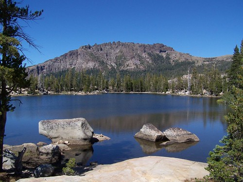
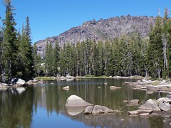
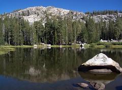
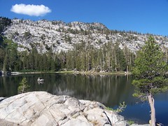
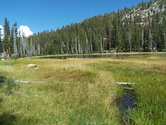
Crag Lake
Meeks Bay is along the west edge of Lake Tahoe, somewhere close enough to the middle north/south that I wasn't sure whether it would be faster to reach it from Sacramento via I-80, heading down from Truckee, or from US 50, heading north from South Lake Tahoe. For the record, Google Maps said I-80.
I took US 50, but with a plan. Before I have gone on these blitzkrieg hikes: drive up there as quickly as possible, get a long hike in without dawdling too much, and drive home the same evening. This time I wanted to dawdle. So I took a more leisurely drive up, stopping to photograph sites on US 50 that have become such familiar mileage marks to me. And I explored South Lake Tahoe, then went to the Taylor Creek Visitor Center and followed the short trails there, which lead back to other turnoffs, Tallac Historic Site & Valhalla.
For the evening, I got a campsite (#153) at Sugar Pine Point State Park for $25. There's a campground directly across the highway from the Meeks Bay Trailhead, but it was just off the road, separated by a chainlink fence. I'm not sure that is the Meeks Bay Campground, though, as when I was leaving the area I saw the sign for it that seemed to lead to protected area below the road.
I set up my new REI tent with no problem, but this was my first night in a sleeping bag on the ground in 18 years. To be fair, I had slept on a kitchen floor of a tiny San Francisco apartment in August of 1998 when all of the inn keepers turned me away (where can you find a good stable these days?), and that was more uncomfortable. But I didn't have chronic back trouble then.
Despite having bought a pad to go under my sleeping bag, and laying the tent on soft dirt with pine needles that gave no resistance to the stakes I anchored it with, I had a hard time sleeping with the discomfort. That could have been a good thing--there was a total eclipse of a full moon that night. But I was under the mistaken impression it was the next night. I'll catch that one next lifetime.
I was just anxious for 6 a.m., when quiet hours ended, to come. It started to get light sometime after 5, and just about 6 some birds began cawing loudly, as though they knew it was now permissible. I jumped right up and set about getting ready, brushing my teeth, eating, packing things up, etc. Then I was off to the trailhead.
Surprisingly, with all that and the preparation for the hike, it took me until 7:35 to head out. It was cold, but I quickly warmed myself up with a brisk pace, and took off my jacket after 15 minutes (I was already wearing shorts). The trail starts as a sandy, unpaved road just off of CA 89, next to private property, with plenty of signs to indicate that. There isn't room for a lot of cars. It seems like it should be a popular hike, with all the lakes you can access, but then it took me a long time to get around to hiking it.
I passed one person headed the other way early on this road, and that was the only person I saw until I started back to the car. The path continues southwest with minimal elevation change until reaching a junction sign marked for the Tahoe-Yosemite Trail. The road continues off a short distance to the left to the former site of Camp Wasiu, according to Tahoe Sierra, while the trail begins to climb to the right.
After a good climb, the trail leveled off and there was a meadow off to my left, filled with dead trees in the western half of it. The meadow near Shadow Lake that I saw later on was much like this, making me wish I knew more about the processes going on in these mountains.
After this the trail followed along Meeks Creek, although it was often not visible, and crossed over the Desolation Wilderness boundary, gradually curving farther towards due south. After crossing a large bridge over Meeks Creek, which could have been walked straight through or stepped over this late in a dry year, the trail began climbing again. At one point it veered to the east away from the creek and then looped back west to it, all so the hiker can make a more gradual ascent that the water's rapid descent.
As is often the case, when I approached the closest point on the trail to the creek, that meant I was just about to hit the lake from which the creek was flowing. I hit a junction sign, marked for General Creek and Phipps Pass (my direction) at Lake Genevieve. It surprised me to see the lake this soon, only 1 hour and 50 minutes into the hike. My map indicated that I had traveled 5.5 miles, which would mean I went much faster than I usually climb in the mountains. But I have two books here at home that say it was a shorter distance, 4.7 miles according to one, 4.6 miles according to the other.
Lake Genevieve was a delight, with a mountain ridge behind it, and a peak farther back. This would be the common backdrop for the first three lakes. The lake itself was a bit grassy and muddy for my tastes, without large sections of granite along the shoreline, or islands of granite.
I continued on the trail down the eastern shore of the lake and past it, only to once again be surprised with how rapidly I reached a lake. It was less than 10 minutes from when I started off from Lake Genevieve until I hit Crag Lake. Crag Lake is about the same width east to west as Lake Genevieve, but more than twice the length of it north to south. It's a bit closer to that dramatic backdrop, and thus prettier. Also helping is the granite western shore of the lake, which rises too steeply for exploration of that side.
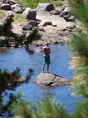
I stopped atop a rock at the north end of the lake right next to its small dam and outlet creek to take the photograph placed at the start of this blog entry. Then I wandered down the eastern shore, looking for access points, but trees and bushes came right up to the lake. About half way down there was a rise of granite boulders, and from here it was possible to see the lake well, but farther along it was trees and bushes kissing the lake's edge, leaving no good area to hang out and swim from.
Passing on, I expected to quickly come upon a junction with a short spur to Hidden Lake. I began climbing and had to rock hop the creek that I was following from lake to lake. It was a minor crossing, but it was nice to see some water flow. I kept climbing, much longer than I expected.
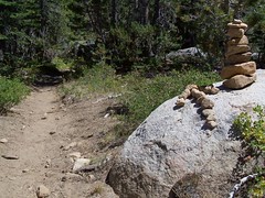
Finally, I saw an unmarked junction. There were rocks laid across the path to the obvious trail to the right, and a cairn over on the trail on the left, indicating don't go right, go left. But I could see Hidden Lake below me at the end of that spur to the right, so I took it.
It's too steep for a good trail, and with lots of loose dirt and small rocks. It would be very easy to slip here, and I don't think the forest service wants people going this way. Midway down, the trail split, with an easier grade to the north end of the lake and a more difficult one to the south end. I went down to the north end.
I don't believe this is the trail on the map, as that heads directly south to the north end of the lake from a junction to the north. This trail headed from a junction directly east of the lake. The contour map also showed less than 20 feet of elevation change on the spur, whereas this was about a 100-foot drop. But I didn't see any other junction or spur trail, even looking again when I came back that way.
Hidden Lake
Hidden Lake is smaller than the other two, and that peak rises directly above it, so close that it is difficult to take it in. It had a nice little granite rock island. After wandering the use trail along its eastern shore, I made the steep climb back up to the main trail and continued my journey.
Soon I was next to the creek with a large depression to the east, and I expected to see Shadow Lake as I came over a ridge. But instead I saw a large meadow, once again with dead trees at one end. Looking back, there was a small lake off the northern end of the meadow, with reeds growing in it. Shadow Lake will not be a lake much longer, as the meadow will eventually win out, only to be supplanted later by forest, if I remember my 8th grade earth science course correctly. As I was passing and photographing each of these lakes I was sizing each of them up for swimming potential, and Shadow Lake had the least potential.
Shadow Lake
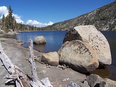
From here, only my final destination for the hike waited ahead of me, Stony Ridge Lake. I made it to the lake with plenty of time left in the day, and had a decision to make. Should I press on to Rubicon Lake? I thought (not knowing of the map's inaccurate marking of distance) that I had traveled a little over 7 miles. It looked like Rubicon Lake would add at least 1.5 miles, making for a round-trip hike of over 17 miles, plus a lot of additional climbing, as the map showed switchbacks up a steep slope to the lake. (Looking now at the mileage from another source, it would have been about a 16.2-mile hike, which is about what I wanted to do that day.)
I decided to stick with my original plan, and hang out at Stony Ridge Lake, waiting for the sun to shift in the sky. Like Shadow Lake, Stony Ridge Lake lies to the east of the trail, making it a better subject to photograph in the afternoon, whereas the first three lakes all were off to the west of the trail.
But I did choose to hike up the length of the lake to its south end, which is smidgeon under 1/2 mile of hiking. I'm glad I did, because near the south end was the spot I had been looking for, smooth granite shelves sloping gently down into the water, the ideal place to hang out next to the water and to lie on while drying out after a swim. I ate a sandwich, and then, not having seen anyone, decided to go skinny dipping.
My Hang-Out
Stony Ridge Lake is easily the largest of the 5 lakes I visited that day, and it looked deep. The stony ridge rises directly from its east shore, shading it in the morning, and the mountain I had been admiring all day rises up from a little ways off the west shore of it, shading it in the late afternoon, all of which suggested to me that the water was likely to be cold.
It was. I initially was shivering. Although that soon passed, I never did get comfortable in it. But I swam longer than I usually do in such cold water. I'm trying to tough it out for longer periods, and jumping into cold showers at home and at the gym to get myself used to that initial shock.
Afterwards, I lied on the warm granite in the sun with my hat over my head until dry enough to put my clothes back on. I took some photographs, and admired the puffy white clouds that had arisen to the north--admired them until I noticed their dark undersides. I had heard on the radio the day before that there might be a chance of rain for South Lake Tahoe that day, which meant there might be thunderstorms in the mountains.
I did stop to take a couple of pictures on the way down, but I went even more rapidly than I had come up. I finally saw somebody else on the trail as I approached Crag Lake on the return, a backpacking couple. From then on I encountered a few others, some day hikers, some backpackers.
When I reached the road I looked at the sky before me and thought, "I had time to go to Rubicon Lake." But as I turned around I saw that back where I had been was completely overcast with dark clouds, and as I drove to South Lake Tahoe, it kept getting more and more ominous over the mountains. Coming down from the pass on US 50, I ran into the rain, and there was a lot of water on the ground from earlier rain. I wonder how the people I passed who were still heading out fared.
Hike Summary
Date: 28 August 2007
Trailhead: Meeks Bay
Approximate distance: 13.4 miles