
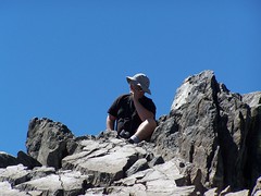
Me on Mt Tallac
One day my friend Erik and I made hasty plans to go hiking the next day. I quickly sent him an e-mail with some hikes I wanted to do in the next few weeks and let him choose one. Two were ones that represented new challenges I felt I was ready to tackle, but I didn't think he would care to try. Much to my surprise, he chose one of those: Mt. Tallac Trail to the summit of Mt. Tallac.
It's a 3225 feet climb from the trailhead to the summit, not counting any additional downs and ups on the trail (which are pretty minimal, thankfully). That's about 500 feet more of climbing than I have done before, and more than 1000 feet more of climbing than Erik has done in the little more than a year that I have known him. It's a hike I had read about last year, but felt I wasn't ready for then, and my plan had been to keep increasing my challenges until I was ready for it towards the end of the high Sierra season this year. Erik skipped some of the intermediate steps I used to build up to this.
The trailhead is at the end of Mt. Tallac Rd. off of CA 89, just across the road from the Baldwin Beach turnoff for Lake Tahoe, and just north of South Lake Tahoe. Everything was clearly signed and we easily made it to the parking lot, got out, then got back in to drive back to use Camp Concord's toilets, since there were none at the trailhead.
Once back to the trailhead, we set out. Initially it was just a dirt trail through forest. It would normally be dry this time of year, but it was even drier than usual in this dry year, and there weren't any wildflowers initially that I can recall.
But soon we began to ascend a ridge with dramatic views to the left (south) of Fallen Leaf Lake and the south end of Lake Tahoe. The trees along this ridge were burned (not from the recent Angora fire, which was on the south side of Fallen Leaf Lake), which gave us more views, but didn't provide us with much shade, and it was warm. I worked up a sweat right from the start of the hike.
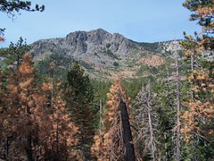
A View of Our Destination
The hike followed the ridge for a while before descending a bit to the right before climbing again, this time without the views. We passed a body of water that two people were stopped at, one with a nice camera. I thought, "Why are they bothering with this pond? They must think it's Floating Island Lake."
Next we came to a trail junction with the path down to the west end of Fallen Leaf Lake, and soon after I spotted another body of water. "Floating Island Lake at last," I thought. Only when I got closer I saw it was also pond-sized. I checked my map and realized that first body of water was indeed Floating Island Lake, and the second one was Cathedral Lake. They were both disappointingly small, and didn't look suitable for swimming. Cathedral Lake did have a nice backdrop, which I might have climbed around the south end of the lake to photograph, if I didn't have such a substantial climb before me.
Leaving Cathedral Lake, the trail turned much steeper, and Erik commented that he had the feeling the real climbing was just beginning. He was right. We climbed through patches of trees, sometimes sparse and sometimes dense, before coming out into an open area that was long and steep. The trail underfoot was loose rock, so the footing was sometimes difficult. We could see a long stretch of the trail on the exposed mountainside here, and saw quite a few people on it, going both direction.
Erik Near the Start of the Long, Steep Stretch
About 1/3 of the way up this stretch I heard some people coming down answering questions from other people going up. I only caught tidbits: ". . . long way . . . up over those . . . about an hour . . . ." The last part didn't sound bad--one hour would put us to the top 15 minutes earlier than I had planned on.
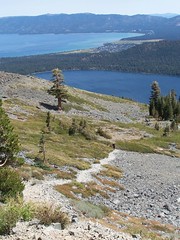
This open stretch had dramatic views of Lake Tahoe and Fallen Leaf Lake. At the top of it, the trail turned away and the views to the east were gone, but they were replaced by dramatic views to the west of the Desolation Wilderness.
The trail in this portion varied, some easy portions, mixed with more steep portions. It was mostly a rocky meadow, with occasional stands of trees. At one point the trail veered off onto a vast slope of talus, and I thought we would have to continue on that. But it was only a detour around a large tree that had fallen across the trail.
I came across a father with 3 girls who told me, "You're almost there." Sometime later I got the same reassurance from two women. And sometime after that I was wondering, "When the heck am I going to come to the junction with the trail down to Gilmore Lake?" That junction marks the start of the final ascent. Right about that time, I saw the junction ahead.
The approach to the summit starts out clearly, although it goes uncomfortably close to a steep drop-off. As you get to the large talus nearest the peak, there isn't much of a trail. The easiest way up seemed obvious to me, and I kept moving at a good pace. Two men who were having a bit of trouble said, "Let's follow him--he seems to know where he's going."
Although the total amount of climbing was far greater, the final ascent to the summit was much easier and sitting at the summit itself was much more comfortable on Mt. Tallac than on Round Top. From the summit, I had amazing 360-degree views. I could see Lake Tahoe, Emerald Bay, Cascade Lake, Fallen Leaf Lake, Gilmore Lake, Susie Lake, Heather Lake (just a smidgeon), Lake Aloha, and two other lakes north by northwest that I wasn't sure of the identities of.
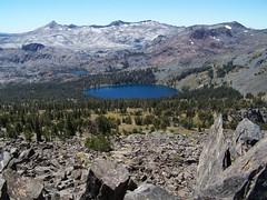
View of Lake Gilmore to the West
Erik would join me later, but I was not alone. There were a few people I had no problem sharing the peak with. Then there were Clint, Judith, Iris, Peter, Jenine, and Cherrie. I know their names because Clint wrote them with a Sharpie on the rock of the summit. Then they headed down to a ledge to throw 3 Frisbees off the top of the mountain into the forest below. They sat around a long time after that, text messaging people, using the cell phone, and throwing rocks at squirrels. One of them asked for the Sharpie and left another message that nobody wants to read.
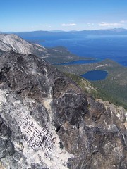
Graffiti in Paradise
I wanted to avoid them, but I also wanted to take some photos from where they were at. I worked my way down and sat a ways off, waiting for them to leave. They talked about leaving, how they needed to get back for the football game by 5 or 5:30. They even proposed racing down. But it took far too long for them to clear out.
Erik Ordering Pizza
Erik came down from the summit, where he had been talking to his wife on a cell phone, just before they left. We then moved down, as did a couple who asked me to take their picture for them. I had eaten a peanut butter sandwich at the summit before Erik arrived, and taken a video of a squirrel after it. I had my second sandwich down below, while Erik also ate his own peanut butter sandwich. The presence of all this peanut butter was too much for the squirrels. They were swarming, darting in to try and get some. I started to shoot some video of squirrels going after Erik's sandwich, but soon found they were after mine. While I was eating, one started to crawl on my shoulder to get at the sandwich. I pulled back. More and more came out, and started making noises to one another. Well, I assume the noises were to communicate with one another. They might have been directed at me: "Surrender the sandwich immediately!"
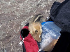
Gold-Mantled Ground Squirrel
Then we began our massive descent. I started out the wrong way, but didn't much care, and picked my way across talus, while Erik searched and found the trail to start down. I had handled the ascent without much problem--it was just sweating and breathing hard and continually moving forward. But it didn't take me long on the descent before I could feel soreness in my muscles and knee joints. I stopped a couple of times just to give them a rest, although I wasn't winded. I hadn't needed to stop on the way up.
Cathedral Lake was my goal. I didn't wait up for Erik or look behind to see how far back he was, I was just intent on reaching Cathedral Lake, where I could take an extended rest stop on the shore. After that, I knew the rest of the descent would be easy. I passed the obnoxious kids and never saw them again.
Near Cathedral Lake, I slipped and fell. I wasn't hurt, but it got a dog at the lake excited. I went down to the shore of the lake, changed my water hose to my auxiliary canteen, relaxed, and waited for Erik. A man called out and asked if he could bring his dogs over to meet me to calm them down. I agreed.
Sophie was the problem, and he gave me a treat to feed her, to make her my friend for life. Then they went back to their area. He later threw a stick out into the lake. Although hesitant at first, Sophie swam out and retrieved it. After returning it to the guy, she came over on her own to see me again. She stood a couple of inches away from me, and then did what I knew she was going to do, shook all over to dry herself off, splattering me. That was fine with me--it was refreshing, and at that point, I'm sure I smelled worse than a wet dog anyhow.
When Erik came along, he also made noise while slipping (although not falling) and this time the dogs raced through the bushes up to investigate. A woman that belonged to the dogs had to bring them back.
It was an easy descent from there. Hearing the jangling of the dog collars behind us farther down the trail, I pulled over at Floating Island Lake to let them pass, while pondering the question with Erik of why this tiny lake was given such a name. There were no islands in the lake. My only guess was that the lake itself must appear like an island in the trees when seen from above. Or perhaps the island in question floated away entirely.
(According to Jeffrey Schaffer in Tahoe Sierra, "In 1890 this unique lake was noted as having a 20-foot diameter floating mat of grass and shrubs, whence the name. In more recent times there have been several floating, grassy mats, and more mats are ready to slough off from the lake's soggy northwest shore. It's a mystery why mats slough off at this lake and not any other.")
After we made it back to the car, I felt the need to indulge myself with a treat for this accomplishment, so we stopped at Burger Lounge in South Lake Tahoe on the way back, and I had a burger smothered in cheese and grilled onions and a Coke filled with high fructose goodness.
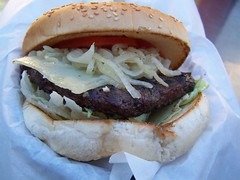
Smothered
Hike Summary
Date: 15 August 2007
Trailhead: Mt. Tallac
Approximate distance: 9.2 miles
Other links: Kevin Gong's description of this trail
2 comments:
You should have pushed those putrefying vermin off the peak!
I know you probably like to take your time and get really good photos when you photograph, and I know sometimes when you are moving you probably don't want to stop to take pictures, but I missed seeing pictures of the things you were describing. Maybe you could take some quick on-the-fly photos to include with the narrative.
Post a Comment