
Grass-of-Parnassus
One of the least used entrances to the Desolation Wilderness is a trail that leads from the Van Vleck parking area to Forni Lake. This trailhead lies more than 25 miles from a major highway, and it does not offer the quick access to lakes and dramatic granite topography that other trailheads offer, but it is the quickest, if not the safest, route to dramatic Highland Lake.
After picking up my friend Erik, we headed west on US 50 to the turnoff for Ice House Road, just before 50 turns into a twisting two-lane highway that runs alongside the South Fork American River and approaches the pass to cross over to the Lake Tahoe region. We drove north that road, past the turn off for Ice House Reservoir and several turn offs for enormous Union Valley Reservoir, until we reached the delightfully named Cheese Camp Road (no, I have no explanation), which was signed for the Van Vleck Bunkhouse and the Desolation Wilderness.
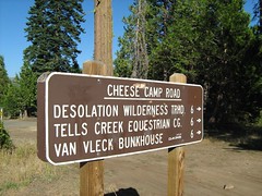
Cheese Camp Road
From here my directions said to drive to a dirt road on the right 500 feet before a locked gate. How would I know when I reached that point? There was a sign that said, "LOCKED GATE, 500 FEET AHEAD." It's a short but bumpy ride on the dirt road to the parking area, where there were day use permits for the Desolation Wilderness.
From there we walked back up the dirt road, then down the paved road to the locked gate and beyond it onto dirt road. There are several old roads out here, some for the Van Vleck Ranch, only one building of which has been preserved, I believe, and old logging roads.
We passed a junction with a fork to the right for the Red Peak Trail, then immediately after a fork to the left for Loon Lake. We continued up the road past a useless cattle guard (there being no fence on either side of it) and some odd piece of yellow equipment on the left with two large wheels, until we reached a weather station and a junction post.
What lies ahead on that road, I don't know. We veered off the to right at the junction and the weather station. Here the trail followed an old PG&E road that has not been maintained. It was single track trail, but with an unusually large gap between the trees, and occasional evidence that this was formerly a wider road. Some small trees have sprouted up, though, and some time in the future, the evidence that there was a road here should be thoroughly obscured.
We passed along quite quickly on this fairly level portion of trail. We were not overwhelmed with dramatic views, but I was delighted to see so many butterflies and wildflowers this late in a dry season. The terrain varied from dense forest to meadow, sometimes mixed with glacial erratics (big granite boulders strewn throughout the forest and meadows).
The first meadow we crossed had a brook bubbling through it, again surprising when everything has been so dry. It later had a boggy area to cross, which must be a major task when there is more water around. Posts with the word "Trail" aided the passage across all the meadows. Other meadows were filled with dead or dieing mule ears and California false hellebore. And yet in some of the forested areas, green ferns were thriving.
Just past one of those meadows of yellowing mule ears, we met the junction sign indicating Shadow Lake on the left fork, and Highland Trail, on the right. We took Highland. It had frequent posts too, only these were much narrower than the earlier "Trail" posts, and said "Highland Tr."
Not longer after we reached the Desolation Wilderness boundary sign, which was interesting only because it was not the same shape as all the others I have seen. From there, the easy hiking was over. The trail immediately started up.
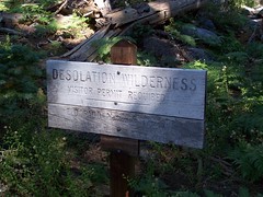
Desolation Wilderness Boundary
But in the brief section of the trail before it got ridiculously steep, I heard, and then spotted, a deer off to the left. Most of the Desolation Wilderness is, not surprisingly, desolate. Dramatic granite landscapes on which conifers struggle to find a foothold dominate the majority of it. This approach took us through much more forgiving, heavily forested areas, which can support deer and their predators, as evidenced by that deer, the only one I have seen in the Desolation Wilderness.
But that was only a few yards in. Then we started up a steep slope where trees were far more scattered. Not only was it steep, the footing was insecure--dirt and pebbles. I wasn't looking forward to descending this part. After the grunt up this portion, we leveled off to a lush area where the trail was mostly overgrown. Late in the year, it had been trampled down for us, but I imagine it is difficult to find the way across earlier.
Not that the path was easy to find for us. The trampled vegetation led us to the east past the talus on the slope to the north, and then up via a sketchy route. No cairns to mark the way this time, just guess work and then corrections. Once we got up close to the high point of the route to Forni Lake, there were indicators. Some obvious trail off to a viewpoint was marked as off trail by a line of rocks and tree branches, and cairns led us on to the short descent to Forni Lake.
This lake is described in Tahoe Sierra as "Hemmed in with vegetation" and "not particularly photogenic." It was not hemmed in with vegetation when we visited, given that the water level was so low. I walked out 25 feet into what was the lake earlier in the year, and now was just rocks coated with dirt, to take some pictures. The sound of fish splashing into the water was constant. At first, I just heard the splashes, and saw the concentric circles in the water, but soon I spotted the fish flashing out of the water to eat insects. Erik asked me why they were jumping out of the water and I told him that the little fishies were just so happy to be in a beautiful mountain lake that they were jumping for joy.
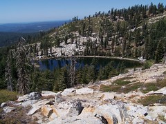
Forni Lake
I thought we were going cross country from here to head towards Highland Lake, and my book told me to head off from the southeast part of the lake. My topographic map, on the other hand, made it look like we should head out from the northeast corner of the lake. I split the difference and headed directly east (the northeast corners would have been correct).
We picked our way cross country, going up wherever it seemed easiest to go up. Then we hit a ridge. There was a depression directly in front of us, and I did not want to go down to head back up again, but it looked like we should have gone up into that lower area. Consulting together and looking at the map, it looked like we should be climbing the ridge on the opposite side of that depression. I chose to skirt around it to the south, lengthening the horizontal distance, but avoiding a lot of additional climbing.
We worked our way over and then TA-DA! There was a trail. Had I read the description of this hike thoroughly, this wouldn't have been so surprising. It is not marked on my Desolation Wilderness trail map, but the trail up to the ridge overlooking Highland Lake is not a use trail, but a trail that was created at one time and even marked with blazes on trees, but which is now unmaintained and hard to follow in places.
We followed the trail up as best we could, searching for cairns often. And then came the ridge. This trail had been one without drama, and then, before me, was all the drama I could ask for. We were on the ridge of a cirque that dropped about 800 feet below with all granite terrain, a beautiful lake (Highland Lake) at the bottom, and Lake Tahoe in the background.

Highland Lake
My original intention had been to go down to that gorgeous lake and swim in it, but it had taken us a long time to get where we were after a late start on the trail, and it was a long way down, and back up. My book warned of the dangers on the way down,which meant to pick our way down safely would likely be slow going. And yet it was beautiful and tempting. I really wanted to swim in a mountain lake that day, and Forni Lake was so shallow that it barely had room for its fish. I let the urge go and left it for another day.
The descent to Forni Lake, mostly via the abandoned trail, was much easier than the ascent, and not just because we were going downhill. It was a better route, even though I couldn't always find it. At one point I was sure I was thoroughly off trail, and then I was just as surely back on trail.
The sometimes confusing descent to the lush area followed, not much more clear than the abandoned trail. And after that, the steep descent on the loose rocks and dirt. As I expected, I slipped a few times, but I didn't fall. My strategy on such loose footing is to keep my feet at a 45 degree angle to the descent, 90 degrees when it gets intolerably steep.
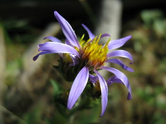
Back down to the easy, but not short, stretch, I stopped to take some macro shots of flowers, and water a tree. After an otherwise lovely hike, the portion of the trail that followed dirt road seemed unduly long and ugly, but at least we were above the valley heat, to which we returned all too soon.
Hike Summary
Date: 24 August 2007
Trailhead: Van Vleck
Approximate distance: 10.8 miles
3 comments:
Tom,
I enjoyed reading about your Forni Lake/Highland Trail adventure out of the old VanVleck Ranch trailhead into Desolation Wilderness. It was very well written with accurate descriptions of the route. I made the very same trip for the first time around 1993. I did it solo as a day hike with the goal of trying out the fishing in highland Lake. I was surprised to learn from others that this is actually the preferred route to reach Highland Lake since to reach it via maintained trail is rather lengthy, being somewhere around 14 miles one-way. According to Jeffrey P.Schaffer’s Desolation Wilderness trail guide, Highland lake is one of the most remote lakes in Desolation Wilderness, and after studying my topo map, going over the ridge from Forni Lake looked like a feasible shortcut.
This combination trail/cross-country route over the ridge from Forni Lake will get you to Highland lake in the 5-6 mile range one-way, but it’s definitely an arduous 6 miles. From what I gathered in your story, it sounds as though you decided not to make the descent to Highland lake from the crest of the ridge. That is ok, since much of this trips value is the view from the ridge and it would have been a lot of work just to take a swim in that lake appearing so far below you. But I can tell you, the lake is absolutely perfect for swimming with lots of great places to jump from rocks (on the south shore) into this very deep lake. If I recall correctly, the lake is the third or fourth deepest lake out Desolation Wilderness’s 100 or so lakes.
Highland lake is one of my favorite places in Desolation Wilderness and you will usually have the place all to yourself due to it being so difficult to reach. The lake is an excellent Rainbow trout fishery, with a very wild and beautiful outlet creek that runs for miles with countless pools and lakelets also loaded with wild Rainbow trout. It is a very special place and my memories of each and every visit have magical qualities with vivid images of the minutest details.
Since that first visit in 1993 I have returned probably around 10 times via the same route. My last visit was in August of 2006. On that last trip my friend and I decided to try a bicycle/hike backpack trip with the goal of getting our bikes as close to the wilderness boundary as possible and then ditching them off the trail out of sight. Our idea was to make quick work of the boring dirt road that comprises the first mile of the hike and take advantage of the relatively low elevation gains up to the wilderness boundary on our bicycles.
It was my first attempt at mountain biking and I gained a lot of respect for even the slightest incline on a bicycle over dirt roads and trails intended for walking. To make matters more challenging, we started our adventure at night, leaving the trailhead around midnight on a Friday night having gotten a late start out of Sacramento after our workday. On the way in, riding and walking the bikes in the dark with headlamps both on our heads and handlebars, I ditched my bike just past the big mule’s ear field you mentioned, not far before you reach the fork in the trail that goes to Shadow Lake. On the way in the bike was not much of an advantage going uphill in the dark, considering we were wearing overnight backpacks weighing between 25-30 pounds.
The bikes really paid off on the hike out as we were able to coast downhill for the last 2.5 miles to our car at the trailhead. Once we got to the dirt road by the weather station we were at the car in less than 10 minutes. I have decide the next time I go to Highland I will do it again even if I do have to push it much of the way up towards the wilderness boundary. The ride out alone makes the hassle of pushing it on the steeper uphill sections on the way in worth it. In retrospect I would utilize a bicycle again for this particular trip.
Usually only having the typical two-day weekend to get my wilderness fix, I have started this hike on a Friday night in the dark many times, with the intention of getting all the way to Highland Lake before making a first camp. Most of these attempts resulted in us making camp at Forni Lake with fatigue causing us to lose our will to continue in the night all the way to Highland Lake. That last bike/hike trip in 2006 was the first time we stuck it out and continued past Forni into the night. The bummer was that by the time we reached the ridge the sun was starting to come up so we just sat there and enjoyed it and then made the 700-800 ft descent to Highland.
We arrived at Highland around 7:00am, set up our tents and took a nap for about an hour or at least until the sun heated my tent to an uncomfortable level. After our nap it was time to get down to the business of catching and releasing some beautiful wild Rainbow trout. It was a great day even though it was what I have come to call “zombie fly-fishing” due to sleep deprivation and the physical exertion that is usually required to get to a magical place like Highland Lake. The only consolation I usually have on a “zombie fly-fishing” day is that I know my tent is waiting for me at the end of the day and a good night’s sleep is in store to replenish the energy level for an enjoyable hike back to the car the next day. It’s what I always used to call “getting the most out of a weekend.”
As an interesting side note, one of my trips to Highland Lake via this route in 1995 ended in a Search and Rescue for my nephew who didn’t make it back to our camp at Forni Lake after spending the day at highland Lake on the other side of the ridge. You can read a brief and mostly accurate account of it on the Eldorado County SAR website here:
http://comspark.com/esarc/searches/95fornilake.htm
That's a fascinating account. I really want to visit this lake, but we had too late of a start that day, and took a little too long to get to the ridge.
I plan on doing it slightly earlier in the year, and when I have camped nearby (at a drive-in campground), rather than driving from Sacramento. That should give me more time. And I have a head lamp now, which should be perfectly adequate for the initial portion.
Tom,
The Search & Rescue for my nephew was quite an experience, being scary for me and I’m sure, even scarier for him. What made it scary was that it was late October with overnight temperatures nearing freezing, and 60 mph winds raged all that night and into the morning. If it wasn’t so cold with the severe wind chill factor, I probably wouldn’t have called for the search and rescue so quickly. I had feared the real possibility that he could succumb to hypothermia in those conditions and didn’t want to waste any time. I had hiked back up to the crest of the ridge in the dark and attempted to call out for Jeremy but the strong winds were overwhelmingly loud making any voice contact impossible. I retreated back to camp for a long sleepless night in my tent next to my nephew’s empty tent, knowing he was somewhere out there without any warm clothing except a hooded sweatshirt. I also knew he didn’t have his flashlight with him, and therefore wouldn’t be able to navigate and keep moving fast enough to generate heat on that moonless night in the forest.
In total, there were 27 volunteers involved the SAR. They started the SAR at daybreak and a 5-man foot patrol met me at Forni Lake, arriving there around 9:00 AM. I took them back up to the crest of the ridge to show them the last place I saw Jeremy. I knew he made it over the ridge from Highland lake because I saw him far ahead and several hundred feet above me just before he crested out on the ridge. I hoped he would wait for me on the crest, but he was an impatient youngster eager to show his uncle what a slow-poke old man he was. He crested out too far to the south, probably just on the other side of that spur ridge you mentioned you used on your ascent from Forni Lake. (by the way, your chosen ascent route on the spur ridge was also the way I chose to ascend on my first visit to Highland Lake) From that area of the ridge, you may have noticed a small pond, partially visible below to the west and on the south side of the spur ridge, opposite of Forni Lake. My nephew saw the pond, mistaking it for Forni Lake, he descended to it. When he got to the pond it was almost dark. He regained the ridge again as darkness set in and tried to get his bearings, but still did not realize there was a spur ridge separating the pond from Forni Lake. He descended again in total darkness on the wrong side of the spur ridge. He finally decided to stay put huddle between some rocks and wait for daylight. When I saw him the next day after being found by the SAR team, his shirt was all ripped up from falling down a few small drop-offs because he couldn’t see where he was going.
Well, so much for recollecting one of my many memorable visits to Highland lake. Back to your plans to visit Highland Lake…….
If you plan on going to Highland Lake as a day hike, I recommend using a bicycle to at least get to the weather station, or better yet continue on the trail and get as close as you can get to the Wilderness boundary, and then ditch the bike in the woods, out of sight.
On a day hike you won't have the burden of a heavy overnight pack like we did and you should have a much easier time riding the uphill sections. You don't need a fancy bike. My friend and I used $100.00 mountain bikes from Walmart and they were just fine for the terrain we encountered. In fact, my friend bought his bike the day we left after he got off work that Friday on his way to my house.
Here is a web page detailing my August 2006 trip to Highland Lake
[URL] http://home.comcast.net/~lzmaps/id44.html[/URL]
On the webpage, there is a video of a spring making its contribution to the outlet creek, about a quarter of a mile below Highland Lake. The outlet creek cascades over clean granite slabs in a chain of pools and lakelets that can lure you on for a couple of miles. The problem is that it’s so easy to be lured along, following the creek down hill, and before you know it you have an uphill hike of three or four hundred foot in elevation gain just to get back to the lake
I suggest using a bike since this hike is a big time consuming hike and using a bike will help you get more time to spend at Highland Lake and perhaps explore down the outlet creek a little.
Post a Comment