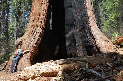
I think we can all agree that this is a big tree.
Come the first week of May, I find myself getting pretty anxious to get up into the mountains again, but it is still too early in the season for the Desolation Wilderness and the dramatic subalpine landscapes of the high Sierra Nevada. About the next best thing is Calaveras Big Trees State Park, which I visited on May 5, 2007 and May 4, 2008. Both years I found just small patches of snow in the forest, while wildflowers were already beginning to bloom. Best of all, Calaveras Big Trees is home to the second northernmost stand of giant sequoia--the world's largest living thing.
My first visit to the park was as much about the trip there as it was about seeing the park itself. I had been to Angels Camp once, six years earlier, but had not traveled through Gold Country on CA 49 from Jackson to get there. So I made plenty of stops coming and going to photograph old buildings and signs in the cramped old gold rush towns that were constrained in their growth by the hilly terrain: Jackson, Amador City, Sutter Creek, Mokelumne Hill, and San Andreas. Some of the old route of CA 49 is now bypassed, as people no longer conform to the terrain, but make it conform to them with TNT and bulldozers.
Amador City

Sutter Creek
Jackson
San Andreas
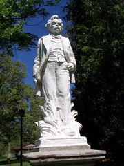
In Angels Camp, the site of the Calaveras County Fair made famous by Mark Twain for their jumping frogs, I re-shot the same subjects from my previous visit. They have plaques in the sidewalk marking the name of the winning frog for each year and the distance of the winning jump. Every year that I visit the county displays at the California State Fair, Calaveras County features frogs. They also have a statue of Mark Twain in a small park in Angels Camp.

Angels Camp
From Angels Camp it's a short trip up CA 4 through Arnold to the park entrance.
Just inside the entrance is the parking area for the North Grove Loop, which is all many visitors see of the park. It is a short and easy trail that takes visitors by some of the most famous trees. According to the park's brochure, Augustus Dowd discovered this grove in 1852. People didn't believe his descriptions of the size of the trees until he brought them there; their reports led to much discussion and made it into the papers. Man reacted as he always does, and staring at the difficult to believe and impossible to comprehend marvel of nature, people wondered, "How are we going to make money off of this?"
The Big Stump
Some entrepreneurs got together and cut down the largest tree. Now you can climb stairs up and stand on the flat stump, known as The Big Stump. They shipped part of the tree around Cape Horn to be displayed in New York City. The show was not a success, and before it could be shipped to Paris, the exhibit burned. Another tree was stripped of its bark, killing it, to be shown in other cities, and a hotel was built in the grove. It operated from 1861 until it burned down in 1943. There were battles between preservationists and capitalist venturers over the North Grove until 1931 when a state bond act, fund raising by the Calaveras Grove Association, and gifts from philanthropists (former capitalist venturers who had already made their fortune) enabled the purchase of the land for the new state park system.
I visited the famous trees, including the famous fallen ones and read interpretative signs about them and saw the pictures of what things were like in a very different era. Then I got to help recreate one of the photos. A gentleman with a vintage camera and a tripod had a binder full of copies of antique photographs from the grove, and he was trying to recreate them, including having people in the same places. So I climbed up on a fallen tree to sit--wearing my Italian hiking boots, REI hiking pants, and polyester Nike shirt--where a woman in a dress had sat over 100 years ago for a photo.
There was a wee bit of climbing to an overlook off the main trail, and I came across some snow. I hadn't been expecting to see any. I came back down and finished the loop, occasionally shooting some of the white blossoms on trees, which I learned this year are Pacific dogwood blossoms, but otherwise not taking pictures. I didn't really know how to capture the wonder of that dark forest and immense trees in a photograph. To give a sense of scale, I would have needed somebody posing for me.
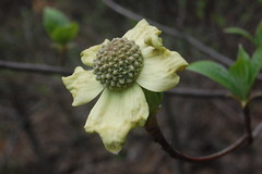
Pacific Dogwood
Then it was back in the car to drive to the South Grove. The South Grove was not assured of avoiding development until the early '50s, and became part of the state park in 1954. The trails here cover a much larger area.
As I headed out on the trail, there was a box interpretative guides that include a trail map for a nominal fee. I passed it up, since the park brochure I received at the admission kiosk included an overall map of the park, with trails marked, although it wasn't too detailed.
I descended to beautiful Beaver Creek, then started an easy climb. At one point the trail crossed a fire road, and then it was off on single track again. At one point I got to a point where the trail seemed to end. Some other people were there trying to figure out how to go on. I pushed through some undergrowth and found trail on the other side, and kept going.
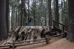
I passed by many big trees, but then got to the ones large enough to be individually named. When I got to the end of the trail at Agassiz Tree, I tried to get a shot with me in it to show the scale. I set up the camera using my Gorillpod and set the timer, then ran over and stretched my hands out around the tree as far as they would go (not far on this enormous tree). The resulting image was a rather unflattering portrait of my posterior, and has since been destroyed.
There had been a split in the trail at some point, and the map made it look like I could do a partial loop back, so I went back a different route than the way I had come.
Soon I found myself doing a lot of climbing. I was huffing and puffing for a long time, and taking far longer to get back than it had taken me to get out. My trail description hadn't mentioned anything about a climb like this, and I had traveled farther on the way back than I had on the way out. While I was completely lost, I laid on my back a couple of times with a wide angle lens and shot up into the soaring trees.

Big Pine Trees, Observed While Lost
Eventually I came out on a fire road. Looking at my map, I was trying to decide which way to go on it, to try and get back to the trail I had gone out on, or to hook up with another trail that would get me back to the parking lot. I started to the left, then changed my mind and went the other way. If I was to the northeast of both trails, then I would be walking away from them on a long stretch of fire road until I hit a creek, and by that time I might have trouble making it back before dark.
I started down the road and somehow missed signs on the edge of the road, one marking the trail I was looking for back to the parking area and another marking a trail to on the other side to some railroad site. I would have walked past them and gotten myself in trouble, but two women, also lost, coming up one trail and out onto the fire road saw me in the distance and called out to me.
We stopped and shared what we knew and looked at the map. They gave up on their original goal of going where I had been, and decided to just follow the trail on the other side of the fire road, which I believe was labeled Railroad Tree. I found out I could get back to the parking lot on the trail they had just come from, the Bradley Grove Trail. Every time something goes wrong in my life just because of bad luck, I like to think of these times when things should have gone terribly wrong, but didn't, just because of good luck.
After that, it was an uneventful return to the car. Studying the maps at home later, I couldn't not figure out what trail I had been on that I did all that climbing on, and how I ended up where I did. In revisiting the South Grove this year, I hoped to figure that out, but I got no clue as to where I was last year.
This year my friend Erik joined me. We skipped the stops along the way, and started with the South Grove, the farthest from the park entrance, and worked our way back, taking three short hikes.
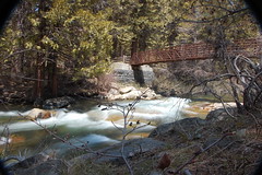
This time, I bought the interpretative guide, and ended up being glad to have it. We set off down a rerouted trail to Beaver Creek--according to the guide, beavers are not native to the area and have not been seen in many years there, but may have been introduced there at one time by trappers. The trail used to go straight to the creek through a meadow, but in an effort to control erosion, I would guess, it has been rerouted around the meadow and is not so direct. Just across the bridge we crossed a patch of snow, and passed the Bradley Grove trail junction.
Beaver Creek
I know next to nothing about trees or wildflowers, and that never used to bother me. But now that I write up descriptions of my hikes, I find my ignorance irritating. I've been reading John Muir's vivid and detailed descriptions of trees he encounters, and here I can't even tell if it's a pine or a cedar. My friend Erik knows a little more than I do on the subject, but he also wants to know more. So with the interpretative guide in hand, we worked on learning to identify at least a couple of trees.
As a result, I can tell you that we encountered mostly pine--ponderosa and sugar--and incense cedar along the one mile of trail up to the fire road. Sometimes we had to crawl over them, as the trail had not yet been cleared.

Giant Sequoia
Across the fire road is the South Grove, and from then on giant sequoia started to appear. The largest of the giant sequoia are unmistakable, just from their immensity. But the younger, smaller ones are easy to confuse by sight with incense cedar. One big difference is how much the bark gives. Pressing into the bark of a giant sequoia is like pressing into a a dry and stiff sponge, whereas the cedar has very little give. The giant sequoia also tend to be surrounded by hundreds of egg-sized cones. In fact, I nearly lost my footing several times slipping on all the small cones filling the trail.
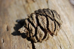
Giant Sequoia Cone
We came to the point at which the trail splits, which was signed. I didn't remember a signed junction from last year. We took the left fork. That seems to be the way I went last year, as it seemed familiar. We joined up with the other branch at another signed junction later on. At one point the trail goes right in between two giant sequoias, and at that point I tried the guide's recommendation on how to best get to know a redwood: lie underneath the farthest outreaching branch and look up at it. I can't report that that particular spot seemed any different than just lieing anywhere underneath it and looking up.
We passed the Palace Hotel Tree and ended up at Agassiz Tree, where Erik was kind enough to indulge my request to pose by hugging the tree for the photograph at the start of this blog entry.
There's a sign near Agassiz Tree indicating the end of the maintained trail, but an unmaintained trail goes farther, and the map in the interpretative guide shows a grouping of giant sequoia nearby, the Moody Group, right on Big Trees Creek, which I figured would make it easy to find. So we hiked on. Soon, I couldn't find the trail anymore. I suggested we go over to the creek to see if we could find a grouping of giant sequoias. We couldn't, and I was getting scratched up going through all the undergrowth (in shorts, Erik had pants on), so we just turned back.
When we got back to where the trails split, we took the southern route this time. We soon came to a bridge with a fallen sequoia next to it, which provided the natural bridge (we took the natural bridge) across Big Trees Creek. I did not recognize this, or anything else until we rejoined the other trail, so apparently I did not hike this part the year before.
Going farther along, we finally started to encounter people, the first we had seen since a father and two boys with fishing gear back at the Beaver Creek crossing. We made good time, and got back to the car without me having any indication of where it was I hiked on my way back last year.
Then we drove to the next trailhead, Lava Bluffs. The park's website describes three trails, the North Grove, South Grove, and Lava Bluffs, although there are more miles of trail. So I figured this was a major trail. The name interested me, and the map showed it was close to the North Fork Stanislaus River, which I was hoping it had views of (it doesn't). But checking online before going, I found two descriptions of the hike which suggested it was a waste of time. Accordingly, I had warned Erik to prepare to be underwhelmed. The main reason for taking the hike was that both descriptions suggested it might be good for spring wildflower displays.
Another thing it turned out to be good for was exercise. The South Grove Trail is easy, and the North Grove Loop is even easier. The Lava Bluffs Trail, which also largely consists of a loop, had me doing a lot of huffing and puffing from climbing, and I was thankful for that. It's lower in elevation than the groves with giant sequoias, and there were a lot of oak trees, as I expect to find in the foothills. What kind of oak I'm not sure--the park's website indicates that there are California black oaks, canyon live oaks, and interior live oaks along the trail.
Mountain Misery
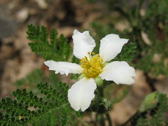
There weren't profuse wildflower displays, but there was a heavy groundcover of a plant with fern-like leaves, only more velvety than ferns. In places, these were blooming with lovely white flowers. It took me a lot of time afterward to identify them, but they are mountain misery, Chamaebatia foliolosa.
At one point we came out into an exposed hillside where the terrain was distinctly volcanic--mudflow blocks. I first noticed these on a hike to Round Lake in the Dardanelles Roadless Area of El Dorado National Forest. They look like blocks of concrete--lots of small rocks stuck together in a big block. Where the trail crosses them, it's easy to slip on the small rocks broken loose by hiking boots and rainfalls.
Here I spotted some fine Dudlyea cymosa (hens and chicks). I stopped to photograph it and wait for Erik, who had either fallen behind because of the climbing, or because he stopped for photographs. He's a big fan of dudlyea, and I wanted to make sure he didn't miss it.
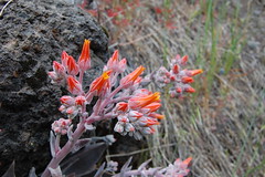
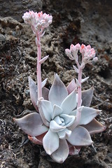
Dudlyea
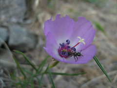
While I was waiting, I noticed another fascinating wildflower, Clarkia arcuata (glandular clarkia). The blossom was too small for me to capture in great detail with the lens I had, but was fascinating to me. There was this incredible tiny world within the petals.
The trail rejoins the other half of the loop right before a sign that says Lava Bluffs. A few yards of trail extend beyond that, and then there is an "End of Trail" sign. So we sat there trying to figure out where the lava bluffs were. But eventually I spotted them, way up high on the ridge, some exposed black cliff. Definitely lava.
The route back, on the lower, southern portion, is longer, but is relatively flat. In three sections of it, you follow and old ditch from an old 250-mile network to deliver water for gold mining. We encountered a couple coming the other way who mentioned they had seen poison oak up ahead, which made me start itching, just by power of suggestion. I got a terrible case of poison oak the last time I was out hiking, and had to get a prescription for prednisone pills.
As we were hiking it had been getting cloudier, after being sunny when we started. And the clouds were getting more ominous. We heard some thunder on the way back to the car.
Then it was off to North Grove. While I think it's a shame that so many people see nothing else of the park, there's no doubt that North Grove is the highlight. It's a very easy walk--I should have changed into my sandals, instead of keeping my hiking boots on--but it takes you through some inspiring sights. You would think that some of the thrill would be gone the second time around, but I found the opposite to be true. I was even more amazed on my second visit.
It started to rain while we were walking through North Grove, hard enough at one point that I put my camera away. Then I was free just to experience the place. I walked with my head tilted up, and nearly lost my balance several times.
I'm sorry that I have no way to show you what it was like. In John Steinbeck's Travels with Charley, he says something to the effect that it is impossible to communicate what it is like to experience a redwood tree with a photograph. I don't know if that's true, but certainly my own efforts offer nothing but support for his position.
Links: Calaveras Big Trees State Park, Calaveras Big Trees Organization
No comments:
Post a Comment