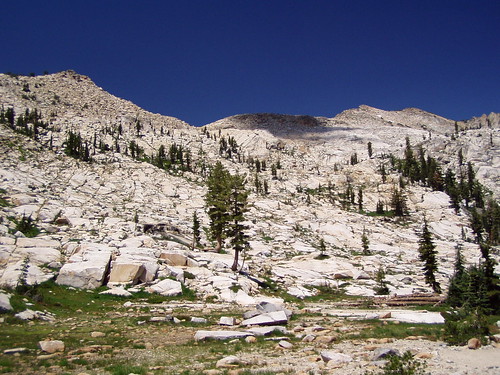
The Mountains Surrounding Lyons Lake
Of all the really great hikes in the high Sierra, this is one of the quickest ones to get to from Sacramento. The trail head is on the road to Wrights Lake.
It's called Lyons Creek Trail because it follows the course of Lyons Creek for much of the way. But while you are never far from the creek, you can't actually see it for most of the time, unless you go a ways off trail.
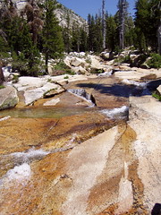
Lyons Creek
There was only one car at the trail head, and I didn't see anybody on my way to Lyons Lake. I did run into a backpacking family when I went on to Lake Sylvia.
The trail follows a pretty easy grade up to the fork where you have a choice between between heading to Lyons Lake or Lake Sylvia. The only challenge was crossing Lyons Creek just before that fork. On the way out, I chose to take off my boots and wade across. I didn't realize the rocks in the stream would be so slippery. On the way back, I rock hopped it. I slipped off the last rock and a little bit of water got into my boot, but not enough for me to bother to change socks.
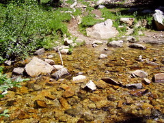
Rock Hop Challenge
At the fork, I chose to venture up to Lyons Lake first. I went from an easy grade to climbing up the side of the mountain. The trail can be hard to follow here, and people leave cairns all over the place. As long as you keep the outlet creek from Lyons Lake close, you shouldn't have a problem finding the lake.
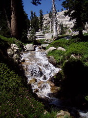
Outlet Creek
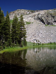
Up top you reach a pond that is in front of the dam for Lyons Lake. It's just a little bit further to the lake itself.
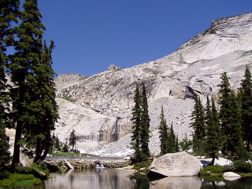
Pond Below, Lake Above
It's a magnificent setting, with peaks rising straight up on 3 sides of the lake. Unfortunately, I had badly scratched my wide-angle conversion lens earlier in the year, and didn't get a replacement until Christmas. There was no way to fit the lake and the mountains into the frame without a wide angle. I'll get that shot this year.
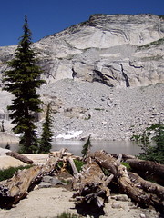
Although it was August, there was plenty of snow on the mountain sides, and a good flow of water coming down the mountain directly behind the lake, so I hiked over there and climbed up for a while.
Then it was back down to go the other way, to Lake Sylvia. There's no challenging climbing to get to this lake--the trail just continues on the moderate grade it followed up to the fork. But the payoff is not nearly so dramatic at the end of that trail.
I had one more stream crossing to make, and a few stops to put on mosquito repellent, as it is swampy around Lake Sylvia. I didn't stay long.
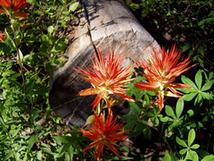
On the hike back I went off the trail to get a better view of Lyons Creek and eat my lunch. Back near the car were lovely meadows filled with wildflowers. Shooting those was a great way to end this rewarding hike.
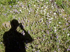
Self Portrait
Update: 2007
I made my second hike on this trail on 1 July, 2007. This time I brought my wide angle conversion lens and my friend Erik with me. It seemed like a shorter trail to me than last year, since I'm in much better shape now.
I raced on ahead of Erik to the crossing of Lyons Creek. The rock hop was a bit easier this year, and I also found a stick to help me with my balance. Once I crossed the creek I waited for Erik and then recorded a video of him making the crossing.
I found the trail much easier to follow up the side of the mountain to Lyons Lake this time. I took a couple of photos near the dam (many of the mountain lakes in the region have small dams to increase the holding capacity of the lake and control the release of water so that those of us living downstream can flush our toilets in September), then I climbed up an outcropping to cross over the shoreline of the rest of the lake. Up top I encountered a ranger, who asked me about my wilderness permit. I had filled one out at the trail head, as always, but I put it in Erik's backpack, rather than taking my own off to store it. I had just seen Erik coming up the trail, and expected him any moment. But apparently he was busying taking photos and didn't come along as expected. This is the only time I've been asked for my permit, and the only time I didn't have it on me. Fortunately the ranger believed me.
I hiked around the west shore of the lake and crossed the stream running down from the mountains on the north end. There was considerably less flow than last year, even though this hike was a month earlier in the year. And this time there was no snow around the lake. From there I climbed about halfway across a pile of granite rocks and boulders coming down from the mountain. I had been planning to cross it all, but it got to the point that the rocks were getting smaller, and it looked unstable. So I went back and joined up with Erik to try some different photographs.
We returned to the west shore of the lake and ate our lunches on a granite slab. Later we crossed the dam to the east shore to check out the view from there. I took plenty of pictures with my wide angle conversion lens, but the results were disappointing. The peaks seemed diminished in comparison to the lake. The best I could do for getting a feel for the location was a video I shot by just turning in a circle to record the whole scene:
Then we headed back to the car. Having spent quite a bit of time taking photographs around the lake, we skipped the side trip to Lake Sylvia to save time. We only stopped a couple of times on the way back to shoot a couple of wildflowers and some butterflies. The wildflower display was really impressive on the main trail, and there were far more butterflies than there had been last year, and of greater variety too, including some enormous butterflies that I was unable to get a shot of in focus.
Hike Summary
Date: 2 August 2006 & 1 July 2007
Trail head: Lyons Creek
Approximate distance: 11 miles & 10 miles
6 comments:
Really interesting. How did I miss your blog?
I like the self portrait and video of Erik crossing the stream.
I would take along a lightweight pair of shoes specifically for creek walking. The other day Raymond and I were trying to rock hop down a creek and finally slipped in and found it refreshingly cool.
We recently tried to backpack in to Wrights Lake via Lyons Creek trail but due to the depth of snow, we camped fairly near the trailhead. We hiked up the road mostly over snowmobile packed tracks. Otherwise we sank! It was beautiful, and our first snowcamp! http://www.facebook.com/album.php?aid=22694&id=1683558814&l=a3390e9ee8
Great post! Keep it up the good work and also keep posting.
Post a Comment