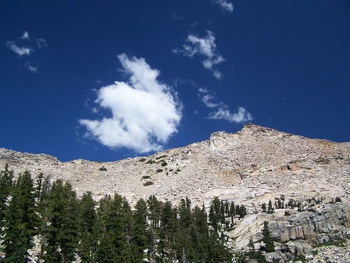
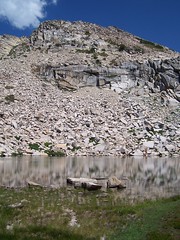
The Mountain Above Smith Lake, 2006
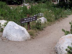
I'm calling this the Grouse Hemlock Lake Trail, even though the final destination of this trail is Smith Lake, while Grouse and Hemlock are the first two lakes you encounter. But the sign near the trail head designates it as Grouse Hemlock Trail.
This is one of many lovely hikes I have done that departs from Wrights Lake in El Dorado National Forest. Taking US 50 from Sacramento you turn north onto Wrights Lake Road shortly before making the final climb over the pass to South Lake Tahoe. Just 8 miles from the highway lies beautiful Wrights Lake, with a campground, numerous vacation cabins, and two trailheads from which you can begin many different hikes.
This hike starts from the trailhead on the southeast corner of Wrights Lake and shares the first portion of the trail with the hike to Twin and Island Lakes. That trail is easier and slightly more scenic than this one, and consequently more popular. It's easier to get away from people on the Grouse Hemlock Lake Trail.
Both hikes enter the Desolation Wilderness, and permits are required. There have always been some at the trailhead when I've been there, but I keep an extra one in the trunk of my car in case there aren't any available.
The trail divides right at the permit site before a bridge. Both ways will take you on a short, flat loop, but the path heading to the right rather than across the bridge is the closest for the turnoff up into the Desolation Wilderness.
Hiking along a lush area (with plenty of mosquitoes), in just .4 miles you come to a small sign that signals the turnoff to the west. Immediately after this sign, the climbing begins. It's then .9 miles to the junction where these two hikes separate. The terrain varies nicely through this stretch, with open granitic areas alternating with forest. If you go early in the season, you may have a rushing creek at times on the left side of the trail, and a smaller stream of water along the right side. But both times I've gone to Smith Lake, I went late in the season when things are much drier.
Shortly after passing the sign marking the boundary of the Desolation Wilderness, you come upon a signed fork in the trail. Left heads to Twin, Boomerang, and Island Lakes. Right heads towards Grouse, Hemlock, and Smith Lakes.
Taking this route to the right, you immediately come upon open granitic terrain. Cairns guide you, but basically you just stay to the right side of this area and at the top the trail is pretty clear entering the forest.
The total hike is only only 3.1 miles one-way. But the trail climbs 1740 feet in that short distance, and when I hiked it in 2006, it was the first hike I attempted rated as "strenuous" in Tahoe Sierra. It was either the second or third hike I made rated 4/5 for difficulty by California Hiking. When I repeated the hike in 2007, this time bringing my friend Erik along, I had already done several hikes that were far more demanding. There are a few steep portions, especially immediately before each lake. But they aren't that long.
When I first hiked the trail and got close to Grouse Lake, I was confused. The trail led right up to the edge of a creek, and I though I might need to cross it. But there did seem to be a trail, although not as distinct as the trail leading up to it, heading directly up. I went that way, and encountered a difficult climb with no clear trail, but cairns set out all over the place that made me think I was going the right way. This way leads to an area above Grouse Lake where there are signed campsites. The trail crosses the creek. In repeating the trip, I led Erik across the creek, and added another cairn to the two I saw marking that path.
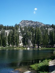
Grouse Lake, 2006
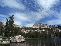
Grouse Lake, 2007
After going along the edge of Grouse Lake, the trail heads up again past another campsite and up into a damp area. It was wet in August of 2006, and I had to carefully pick my way across. In July of 2007 it was much drier. There was still plenty of green plant life and colorful wildflowers, but it was easy to cross any old way.
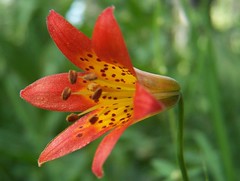
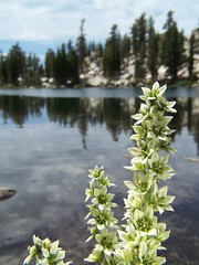
Tiger Lily
After this, the trail begins another steep ascent. Off to the left of the trail if you wander over to the edge of the rocks there are magnificent views of the Wrights Lake Area and a large lake that I believe is Union Valley Reservoir. The last one before the trail levels off to approach Hemlock Lake has the best view.
Hemlock Lake, 2006
After passing by Hemlock Lake, the trail takes an easy climb through a wooded area, and then starts a steep climb to the edge of Hemlock Lake. It is hard to follow this portion of the trail. There are cairns every which way. In 2006, I started climbing too quickly straight up to the west, rather than making a more gradual ascent to the southwest. Following cairns that shouldn't have been left there, I often found myself backing up to find an easier route--which followed other cairns. When I made my return, I added more cairns to the easier route, and knocked away some that had led me to dead ends.
I had a much easier time in 2007. I've gotten better at spotting the trail and cairns, and knew the situation. Each time I was in doubt, I looked around at all my options and didn't just follow the first cairn I saw. I looked for the ones that seemed to follow the easiest climb. Again, I added cairns to help mark the easy way. Behind me, Erik got misled and didn't start up soon enough. That meant he had one small tough climb to make up for that, but then was fine.
In 2006, I had Smith Lake all to myself, and hadn't seen anybody on the hike there. I thought about swimming, but the water looked frigid. I dipped a hand in to test it, and then just sat down and ate a sandwich before leaving.
In 2007, there were a young couple and the father of one of them at the lake when we arrived. The couple were in swimsuits and standing in the water. The man eventually jumped in, but didn't stay in long before coming out. The woman just stood with the water up to her knees, and despite all of the man's coaxing, never went in.
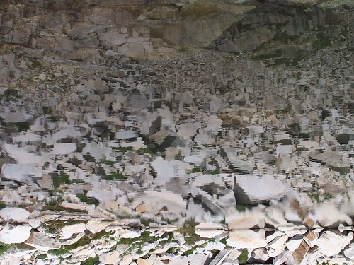
Erik and I went across the dam (all of these lakes have small dams to increase the holding capacities of the lakes and control the outflow of water) and climbed up on a granite cliff above the deeply blue, clear water. I could see the fish perfectly.
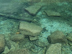
Clear Water of Smith Lake, 2006
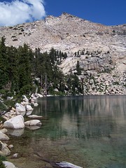
Smith Lake, 2006
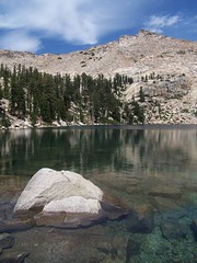
Smith Lake, 2007
Then came the return. Hemlock Lake had been described in one of my books as suitable for swimming. As I returned to it in 2006, I still had not seen anybody, so I decided to go skinny dipping. That didn't last long. It was too cold for me. In 2007 we just stopped to take photos, since we had passed by it quickly on the way up.
Hemlock Lake, 2007
Hemlock Lake Reflection, 2007
In 2006, I didn't encounter anybody until I returned to Grouse Lake. In 2007, we saw quite a few people and dogs on the way back. After getting back to the car, we drove over to check out Dark Lake, and then drove home via Ice House Reservoir to take a gander at that, rather than taking the direct route back to US 50.
Hike Summary:
Date: 18 August 2006 & 23 July 2007
Trail head: Twin Lakes
Approximate distance: 6.2 miles
3 comments:
Enjoying the photos and narrative.
Thanks for posting this info. We're going to Hemlock Lake this weekend. Your info will help us locate and follow the trail.
This was great to rread
Post a Comment