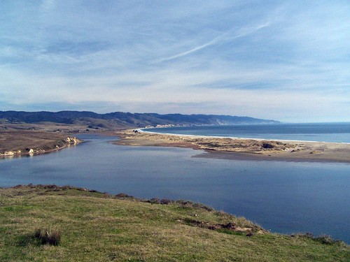
Limantour Estero & Limantour Spit from Drakes Head
Two of my friends from work, Dana and Erik, joined me on this hike, which helped defray the expense of the gasoline. It's a long ways from Sacramento to the trail head for Muddy Hollow Trail at Limantour Beach.
Muddy Hollow Trail is marked on the full map of the park that you get at the visitor centers, but it is not on the north district trail map. We soon found out why. A sign indicated that the trail was unmaintained, closed, and dangerous. We did not see anything that would be considered dangerous, but I imagine during wetter years the trail may be flooded. It was muddy in parts, and only slightly above a flow of water down the middle of the ravine.

Two Deer Reenacting the Classic Marx Bros Mirror Bit
After following the trail along some low power lines (this area was all slated for development at one point and some houses were built--now they house park personnel) we ended up on a gravel road, and then arrived at an alternate trail head and parking lot for Muddy Hollow Road that had quite a few people at it. Muddy Hollow Road is a trail, whereas the section of Muddy Hollow Trail we had just come off of is a road. This is the sort of thing that would have bothered me when I was younger.
We followed along Muddy Hollow Road until we reached Glenbrook Trail. As I had originally planned this hike, this is where we would turn to make a loop. But I had been sorely disappointed by the lack of photographic opportunities so far, and I new Drakes Head was pretty dramatic from my previous visit there. So I gave my hiking companions the option of returning, but talked them into continuing on to Drakes Head, which meant proceeding on White Gate Trail and Estero Trail to Drakes Head Trail.
The trail here is unmaintained, and difficult to follow, but it's just cow pasture. As long as you know where you are going you'll get there; it's just that you end up going through some heavy brush if you veer off trail. Damn near every plant looked like poison oak to me. I scrubbed long and hard with Tecnu when I got home from this hike.
We made it out to Drakes Head, where the view was indeed dramatic. In between Limantour Spit and Drakes Head is a lagoon that had sharks swimming in it that we could see clearly. I didn't get much in the way of photographs, though.

Before There Was GPS
At the junction of White Gate Trail and Estero Trail, we took a right and continued to follow Estero Trail, rather than going back the way we had come. By this time, the hike was feeling quite long. I began to worry that we might have missed a turn we were supposed to make, but Dana's good sense talked me into continuing.
Dana has a long stride, and we were making really good time, but Erik had fallen back. When we came across several rabbits in the middle of the trail, we decided to hang out and watch them while Erik caught up so he would get a chance to see them too. They never let me get close enough to get a good photo.
We made it back to my car shortly after this. Erik and I chose to walk over to popular Limantour Beach just to get a look at it. Since Dana's hiking boots had tortured his feet, he chose to stretch out in the luxury of my '98 Chevy Geo rather than join us on the beach. All 6' 4" of him. Just before the beach there was a small pond, where Erik got a nice shot.
Hike Summary
Trail head: Limantour Beach parking lot
Approximate distance: 14.9 miles
Map: North District Trail Map
1 comment:
If only you could find someone to pay you a living wage to be a trail guide...
Post a Comment