I've been anxious to get up into the high Sierra and Desolation Wilderness, but it's still a little too early in the season. The best alternative I could find is a hike from Wrights Lake that stays to the west of Desolation Wilderness.
I started out the same as I would for Rockbound Pass Trail and Tyler Lake Trail, with a short and easy jaunt to Beauty Lake, with nice views of the mountains to the east along the way. There a sign saying "Jeep Trail" points on to the west. Following that trail, I soon reached the jeep road. I'm not sure if this road is still open to jeeps, as many OHV areas were closed in national forests as a result of a 2005 court order. But according to my hiking book, it wouldn't be open to vehicles this early in the season anyhow.
One obstacle on this road stood between me and my destination: Jones Fork Silver Creek. The road crosses it at a broad point--about 20 feet across--so that it is more shallow for vehicles. Tahoe Sierra advises hikers to rock hop upstream.
I worked my way upstream and found a place where I could make an easy rock hop to an island, but then I had to find another spot to cross the rest of the creek. That proved challenging. I fought my way through the brush up the island and finally found a place that I could make a moderately difficult and circuitous crossing, using my hands at times, and stepping on a rock that had about an inch of water flowing over it.
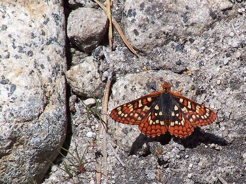
I worked my way back to the road and continued on. At first it rises close to the creek, with nice views of the water. Then it turns away. At one point it passes through a clear area with granite shelfs where there are more good views of the mountains to the east. In some of the damper areas, there were lots of butterflies and dragonflies.
As I was wondering how far I was from crossing Big Silver Creek (not so big, really), I got out my map and checked my compass. The compass indicated that I was heading ENE, when I should have been heading NW, according to the map. I checked the directions I had written on the opposite side of the map, and saw that I was supposed to take a fork in the road to the left sometime between the two creeks. But I had not seen a fork. I worried that I had missed it, and decided to head back.
A while into heading back, I began to questions my decision. I stopped and checked the compass several times, and it indicated I was heading SE, which means I had been going NW when I was going the other way. I think my first reading was probably inaccurate, as the compass would read one thing when I would look at it, then it would settle on a different direction after I shook it. I thought about returning, but decided I had committed too far on my return.
I got back to Jones Fork Silver Creek. At that point, I planned to just give up and return to my car. I tried to comfort myself with the thought that I could walk around Wrights Lake and take pictures. But I really felt like Faye Dunaway's character in Barfly when she bites into the corn she was so excited about only to find it green and inedible and sobs, "Nothing ever goes right!" (or something to that effect).
I thought about how I had been anxiously awaiting the end of the work week from the hour it began, just so I could get out on the trail again, and how there was plenty of daylight left, seeing as how it was June 16, and I turned around and continued my aborted hike. I thought it was likely I would run out of water, as I drink an awful lot of it when I'm hiking, but I didn't think it was likely that I would be seriously dehydrated.
As I returned up and down the hills (there's only 490 feet of net elevation gain on this hike, but there are lots of ups and downs, and it is rated as moderately difficult in Tahoe Sierra), I kept a close watch for a fork in the road. I did not find one. But well before I reached where I had turned back, I spotted a foot path heading off the left side of the road. The book didn't mention it, but a look at the map showed a trail that paralleled the road. I don't know why I hadn't looked at the map closely enough to see that before. My friend Lucy makes fun of me for doing so much research and preparation for my hikes, but I often wish I had done more.
The jeep road hadn't been that bad for a road, but the trail was better, with the trees much closer. As usual, many had fallen across the trail. I scratched my leg on a branch while stepping over one, and had about a 4 inch line of blood on my leg. Nothing worth stopping for.
Part of this hike is on private land, and as I got close to Big Silver Creek, I saw a cabin off to the left. After I crossed the creek (very easy crossing), I turned off the road on a path marked with a cairn. Following that, I came to a road heading east-west, while the path continued north. I consulted the map, and it showed both a road and path heading north up to Barrett Lake. It didn't show anything heading east to Pearl Lake. I thought it would be safer to head east than continue north, so I took the road. It came to a dead end where there were many sawed logs blocking the way. I assumed it continued on the other side, and went around the logs. But I didn't find any road on the other side.
I knew I was close to Peal Lake at that point, and that Big Silver Creek off to my right drained Peal Lake, so I figured I would just keep heading upstream cross country. Soon I could see a trail or road: sometimes it seemed like a jeep road, sometimes it seemed like a hiking trail. I followed that and arrived at Pearl Lake in no time.
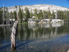
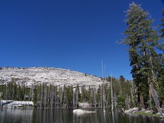
Pearl Lake
I wasn't expecting too much from Pearl Lake, as it is not even mentioned in California Hiking (at least not in my older edition). But I was pleasantly surprised. I arrived at a small dam (all of these small lakes have them to raise the lake level and control the outflow so that we can have water downstream in August and September). On the north shore were wonderful granite cliffs with flat tops, ideal for hanging out, and a much larger granite outcropping rising above them. My pictures don't do the lake justice.
Starting on the south shore, I worked my way around the lake. Around the southeast corner, I saw patches of snow. I stopped and had lunch on top of those cliffs, overlooking the lake. I checked my water and knew I would soon be running out.
When I returned, I took the path/road all the way to where it met up with the jeep road, at which point there was a sign nailed to a tree with an arrow that said "Pearl Lake 1/2 mile." I also saw some equipment there, and a friendly woman out working with a wheelbarrow. She asked if I had hiked in from Wrights Lake and if the campground was open, and told me she hoped I enjoyed my hike. I was surprised to see her. I had seen 3 backpackers coming the other way when I first started out on Rockbound Pass Trail, but she was the only other human I encountered on the hike.
After crossing Big Silver Creek, I thought about taking the road back rather than the trail, so I could figure out just how close I had been when I started back. But I didn't see any other way to go, other than the way I had come.
I took the trail back to the road There had been mosquitoes out in the wetter areas on the way out, but in the late afternoon on the way back, there were mosquitoes along the entires course of the hike. I provided dozens of them with a good meal.
When I got close to where Jones Fork Silver Creek was visible, I looked for an easier way to cross it. I climbed downhill at one point thinking I could find a spot, but I didn't. So I headed over to the creek again close to where I had crossed it before. I searched all over to find either that same spot, or an easier one. I had already run out of water at this point, and as I was climbing up and down rocks on the bank of the creek, I was getting really thirsty. Eventually I found the point I had crossed before, and made it back across.
At this point, I stopped to try and get some water. I carry a Platypus canteen in my backpack with a hose and mouthpiece, so I don't have to stop for a drink of water. When I can't get anymore water out through the hose, there is usually still a small amount of water left. So I stopped to take it out and get that last mouthful of water.
And then it was back on the path. I found myself starting to drag at points, so I pushed myself to hike faster. I wasn't hiking at the same speed I set out on, but I didn't want just plod on. I kept thinking of the water spigot back at the trail head.
When I reached Beauty Lake, I knew I was close to the end. Back at the parking lot, I filled my canteen to the half way point, and drank it all. It turned out to be a better workout than I expected, although I didn't take as many pictures as I often do. Anytime I stopped for a photo, the mosquitoes were all over me. I think I have more bites on me than I have ever had at one time before.
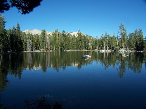
Beauty Lake on the Return Trip
Hike Summary
Date: 16 June 2007
Trail head: Rockbound Pass
Approximate distance: 9.4 miles (as listed in Tahoe Sierra, not including my additional wandering)
3 comments:
I wish I could take my cameras and computer and go back in time to when Dad took us to a lake... somewhere in California... probably south eastern Sierras, but I have no idea. Now it is just a vague memory.
While sitting here reading your wilderness experience report I glanced up and out the window and noticed a mottled patch of brown in the tree at the bottom of the driveway. Red Shouldered Hawk. Got the camera, but when I went out the front door it flew off. Do you try to get photos of hawks and the like while out on your hikes?
Keep it to yourself or it will be overrun....by newcomers like yourself!
Post a Comment