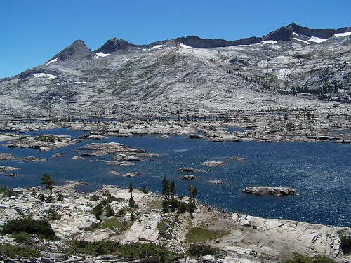
Lake Aloha
This hike presented me with an interesting view of the different ways people use and have historically used the beautiful lakes of the Northern Sierra for recreation. To get to the trailhead, I drove up US 50 to South Lake Tahoe, then headed up CA 89 pass a 7-Eleven, motels, burgers joints and other businesses, past USFS campgrounds and a private resort and turned left on Fallen Leaf Road.
Fallen Leaf Road is paved, but narrow and rough in spots. Once past Fallen Leaf Campground, it winds through a residential area in the forest along the south shore of Fallen Leaf Lake. I could catch glimpses of the beautiful lake through the trees, but mostly I saw driveways, SUVs, trashcans, and "Private Property" signs. The homes ranged from simple cabins and A-frames, to newer, far more expensive luxury dwellings, with large rock walls and newly paved driveways.
At the western edge of the lake is a marina, with plenty more reminders that it is private property. The only people without stacks of cash that are welcome here are those who make this lifestyle possible--those working on the roads, collecting the garbage, or risking their lives to save the houses nestled in the dense forest from fire. Those same firefighters from the Angora Fire that I saw thank-you signs to along highway through South Lake Tahoe had better not think about trespassing on the land when there is no fire to enjoy a day off on Fallen Leaf Lake.
Soon after the marina the road ends in the parking lot for the trailhead. This is a popular entry point for backpackers. By going on a Sunday, I hoped to meet most of them coming the opposite direction as they finished their weekend adventure, rather than up by the lakes. But not enough had left to clear space in the parking lot. There was one little spot I was able to squeeze my Metro into out of the way, but I couldn't have parked there with an average car.
The beginning of this trail is a closed, but not unused, road. It is nicely groomed gravel from the gate at the trailhead up to another gate, a better road than a couple I have driven on to get to trailheads. At the second gate is a warning that the next mile passes through private property. The road turned rough and started climbing. It would be suitable only for high-clearance 4WD vehicles, although there were spots where a bit of old pavement remained.
On this road I passed by cabins and driveways, and saw a couple of vehicles parked. The "Private Property" signs were out in abundance. There was a nice waterfall off to the west of the road, but the best point to view it would have been from a private cabin that was falling apart, and had a broken canoe in back with wood piled on it.
Farther up the road I came to signs for Glena Alpine Springs Resort. One of my hiking books mentioned a ruined resort, and I was interested in the possibility of exploring the ruins. But it is a site that is being actively preserved, and used for special occasions. The website mentions that tours are available, which I would like to go on when I have more time. I passed a pavilion with interpretative displays and a volunteer on hand, but given the length of this hike and how long it had taken me to get to the trailhead, I didn't stop.
Immediately after this they are trying to erase the signs of the old road, strewing branches across it to keep people from walking there and to encourage new growth, so the path becomes narrow. At the end of this old road I found a confusing sign. It was a junction style sign, a four-sided post with Susie Lake listed on one side (my first destination of the day), and Grass Lake listed on another side (not where I was going). But I only saw one trail ahead, and it seemed to lie in between the two arrows pointing the way.
I started up the obvious trail, then came back down to look for another trail again, but I still didn't see anything. I went back up, heading the wrong direction on my compass from the direction I though I should be going, but the trail then swung around to head the way I expected to go. My map indicates that the first junction occurs just before the border of the Desolation Wilderness, but that was not the case. I passed the sign for the Desolation Wilderness just before reaching the junction, signed Grass Lake for the left fork, and Mt. Tallac for the right fork On the opposite side of the sign it indicated Susie Lake in the same direction as Mt. Tallac.
It was a steady climb up from there, but well graded, and it was cool and windy. I was able to press ahead at a much faster pace than on my recent, much steeper hikes. I did pass my share of backpackers coming the other way, as expected. I was surprised by the number of men who said "howdy" in an unusually deep voice. Nobody ever said "howdy" to me in all the years I lived in Montana.
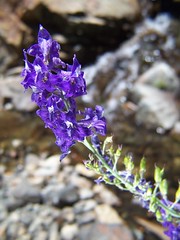
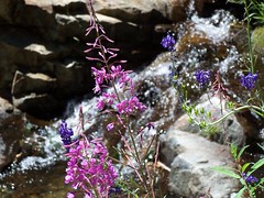
Towards the top of this climb, the trail parallels a creek. I stopped to take some photos of wildflowers next to it, then soon crossed the creek. Only it was completely dry where I crossed, even though I could see and hear water flowing farther up and farther down the creek. Apparently the creek was flowing down below the rocks. From the evidence of the dry creek bed, however, I imagine this is a difficult crossing early in the season.
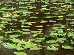
Pond
Right after this crossing was the next junction, signed Dicks Pass to the right, and Lk Aloha, my way, to the left. I continued in the forest and descended past some ponds and swampy meadow before reaching the next junction. I knew my branch was to the left, but I circled the sign to find the confirmation that Lk. Aloha was that way.
Soon after this, I caught a glimpse of the drama of the Desolation Wilderness in the distance, but soon descended where I couldn't see it. Then I climbed up and came out at Susie Lake.
I had hoped to go swimming at one of the lakes I was visiting that day, but the wind was whipping and it was cool at Susie Lake, and I was only headed up from there. I saw one camp set up right where the trail reaches the lake, in a horrible spot--right next to the trail with all the people passing, and right in the wind, and on damp ground.
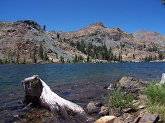
Susie Lake
The trail winds around the southern shore of the lake, dropping away from it at one point to cross the outlet creek. As I started leaving the lake, I started climbing again.
It wasn't a bad climb at all, or very long, before reaching Heather Lake. Another beauty of a lake, but the trail here was not so great. It goes along the north shore of the lake, along the pile of granite rocks crumbling off the mountain. It climbs to a point where there is a steep drop off to the water, the footing is never too secure, and it looks like a rock slide is always an imminent possibility To top it off, the wind was blowing fiercely in my face. At the northwest end of the lake I was much closer to the shore, and was protected from the wind.
Then began the next climb, although not too bad. On this part of the trail, I encountered some surprises for a wilderness area--a wooden bridge across a creek, and a boardwalk across a meadow above a pond that must be flowing with water much of the hiking season. I climbed up near the face of a distinctive rock outcropping that I had seen from a long distance before, and didn't think I would be coming that close to.
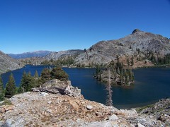
At the top of that climb was the junction at the northeast corner of Lake Aloha. I was well prepared for this dramatic sight, having seen it on the map many times, and seen photos of it on Flickr. But there is nothing like experiencing such drama in person.
When my friend Erik and I hiked passed Granite Lake on our hike to Middle Velma Lake, he observed that all the lakes we saw in the Desolation Wilderness could be named Granite Lake. There are also a few Island Lakes, and many more that could be named so. But none could lay better claim to those two names than Lake Aloha.
It is vast and deep blue, but shallow. Innumerable granite islands dot it, and a vast slope of granite rises up to the west, while lower granite formations lie around the other sides of it. My hiking books had warned that this lake is popular among backpackers, and even croweded on weekends. But I didn't see anybody initially, and felt completely alone in the strong winds of this harsh environment.
I went a ways south on the east shore of the lake and then went off trail to climb some rocks above the lake for a better view. On my way back, I stopped off in a protected area that had obviously been used as a campsite to eat a sandwich. After that, I headed back to the junction and this time went west along the north shore of the lake.
Here I saw other people, off on the lake shore south of the trail. But there was plenty of room for all of us, and there were no "No Trespassing" or "Private Property" signs along the trail.
I hiked as far as the trail kept close to the shore, before it turned away from the lake and up into an area I will probably never see unless I start backpacking myself. At that point I headed off trail to find some unobstructed views on the rocks above the lake towards the east. This is not the most dramatic view of the lake, but it was one that had the sun behind me for better lighting.
Heather Lake
I headed back towards the junction, but veered off it to get closer to the lake's edge. Somewhere along here I found a plastic bag, which I grabbed and stuffed in my pocket to take out of the wilderness. If you allow everyone into the wilderness, of course, you will have those that fail to respect it.
Heading back towards Heather Lake, I decided to take a detour off trail to check out the view from a high point, and found that Heather Lake was more extensive than I had realized. I similarly wandered off trail to explore a few other photo opportunities, but as I got farther down, I started speeding up. I promised myself dinner at Burger Lounge in South Lake Tahoe if I made it back to the car by 6 p.m. I made it back 20 minutes earlier than that.
Hike Summary:
Date: 5 August 2007
Trailhead:Glen Alpine
Approximate distance: 14 miles
2 comments:
Don't know if you've seen it but http://www.gmap-pedometer.com/ is nifty for showing where you've gone...enjoying your posts.
Thank you for the nice post.
Post a Comment