In California US 50 follows a route historically important both for 19th century immigration and for the development of automobile travel and the highway system. From South Lake Tahoe to Folsom, the current U.S. Route 50 roughly follows the immigrant wagon train path. In the early 20th century, this became the southern branch of the Lincoln Highway (the northern branch went from Truckee to Sacramento roughly along the old U.S. Route 40 and current Interstate 80 path). From its origin in 1926 until the completion of the El Dorado Freeway (current U.S. 50) in 1973, U.S. 50 ran from Folsom to East Sacramento and Midtown via Folsom Boulevard.
Unlike many stretches of old U.S. 40 in the greater Sacramento area, business has continued to flourish along most of the old U.S. 50 route on Folsom Blvd., despite being bypassed by the freeway. It remains an important east-west artery through East Sacramento, and is the main business thoroughfare in Rancho Cordova.
As a result, Folsom Blvd. is lined with a hodgepodge of new and old. I'm going to highlight those old portions that can still be seen, or could be seen in the last few years, while taking you on a trip down Folsom Blvd. from its west end at Alhambra Blvd. in East Sacramento to Rancho Cordova, leaving the historic mining town of Folsom for another blog entry.
3145 Folsom Blvd.
Rosemount Grill
[Historic photo of the Rosemount Grill.]
This long-time Sacramento institution was originally located downtown, but moved to Folsom Blvd. around 1940. When the owners retired and sold the place, the new owners wanted to maintain the tradition, but the family didn't want somebody else running the business under the same name, so the old neon sign was carted off to the Sacramento Archives, where it is still preserved, and the restaurant became Andiamo's. I had an Easter Buffet there once long before learning anything of the restaurant's history.

3201 Folsom Blvd.
Regal Station

This was the sign for a gas station from the Regal Petroleum Corporation. In the early 1970s, the lot was used for a car dealership, and the owner made good use of the sign, naming the business Crown Auto Sales. Really, Finish Master? Why not be the Finish King, rather than just a master? Restore the crown!
3300 Folsom Blvd.
Philipp's Bakery
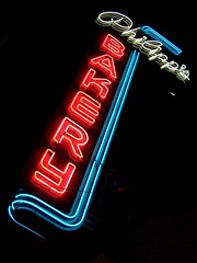
This place I was able to get a little insider information on as I was photographing it one night and ran into the owner (as he told me, co-owner with his brother as I found out later). His last name was Philipp and this had been his father's bakery, but it had passed out of the family hands. He (and his brother) did well in business and and bought the bakery, and his wife was running the bakery. He gave me his business card and hers. But then shortly after, the bakery closed, and an article indicated the two brothers had evicted the baker tenant. Odd.
Anyhow, he had the sign restored by Pacific Neon. Just in case there would be some objections to putting it back up, he had the work done on the sign in place. They discovered that, while it had not been used that way for years, the sign was designed to be a flasher, so it was restored that way. But he soon found out why it had been altered, as a part costing a couple of hundred dollars needed to be replaced every few months.
4300 Folsom Blvd.
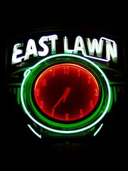
East Lawn Memorial Park
4757 Folsom Blvd.
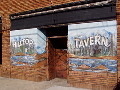
Hilltop Tavern
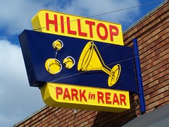
Formerly a small grocery store, the Hilltop opened in the late 1950s or 1960, and when I first saw it, had lovely murals out front, which are now gone.
4800 Folsom Blvd.
East Sacramento Hardware
From at least 1953 to 1982 this was Sacramento Building Specialties, and it has been East Sacramento Hardware since at least 1990.
4920 Folsom Blvd.
Burr's Fountain
I'm curious about this place. It has only been an ice cream shop since the late 1970s or early 1980s (first Vicki Marie's Ice Cream before becoming Burr's Fountain). Before that it was Zarett's Pharmacy, dating back to the 1950s, which looks like the right age for the building. It's possible that it had a soda fountain in it as a pharmacy, which would make it one of the oldest in Sacramento. The counter inside is certainly much newer than that, but whether it replaced one from the 1950s, I don't know.
Owned by the same people as venerable Vic's Ice Cream across town (according to a friend), the menu is much the same--you can still get your sandwiches, which come with potato chips and pickles, on dark rye, and you can get a braunchweiger sandwich to go with your phosphate.
5200 Folsom Blvd.
Socals

While this has long been a tavern, it has only operated under the names Socals since the early 1970s. In the '50s and '60s it was the Clover Club.
5201 Folsom Blvd.
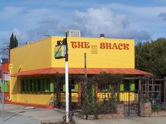
The (Sub) Shack

Born in the early 1970s as The Sub Shack, it has gone upscale under new owners and dropped the "sub" part, and is now a small eatery with a lovely outdoor area known as The Shack.
5723 Folsom Blvd.
Square Deal Cafe/Espanol Italian Restaurant

The Espanol Italian restaurant started as the restaurant in a Basque boarding house for sheepherders, the Espanol Hotel, at 114 J Street in 1923. Ancil Hoffman bought it during the depression and turned it into a celebrity hangout. Ann Sothern and Max Baer frequented the place. In 1952, it moved into the Commercial Hotel at Third and I. In 1959 the Luigi brothers bought it and gradually changed the food served from Basque to Italian. In 1965 it moved to its present location because of the construction of I-5 where the Commercial Hotel once stood. The building formerly housed the Square Deal Cafe.
5810 Folsom Blvd.
Corti Bros.
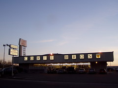
This was the Grand View Market in the 1950s, and Giant Foods in the 1960s, but as the sign tells you, Corti Bros. has been around since 1947. They started downtown, at what was presumably a much smaller location, then moved to 3195 Folsom Blvd. before moving even farther out to this spot around 1969-1970, presumably following their customers in the flight from downtown.
They usually win any local vote for best deli, and have a fine selection of specialty import groceries. It's where I go every year to get lefse, and the only place I can find in the area that it is available.
5901 Folsom Blvd.
Camellia Cleaners
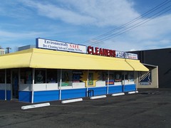
Camellia Cleaners has been here since at least 1970. Before that Bossy's Drive-In had this address, but I'm not sure if it's the same building or not.
6200 Folsom Blvd.
Giovanni's Pizzeria
This was a tractor supply business for most of its early life, which gives you an idea of the changing character of the area, as this used to be the edge of town. This is my favorite place for New York style pizza.
6300 Folsom Blvd.
Hoppy Brewing Co.
And this placed housed a feed & farm supply company.
6601 Folsom Blvd.
Sambo's Pancakes

It was built as a Sambo's in the mid 1960s, and remained one until at least 1982, and has been a series of restaurants since then.
6727 Folsom Blvd.
Dairy Queen Drive-In No. 52
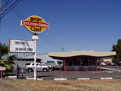
It started out as a Dairy Queen in the mid 1960s and remained one until the early 1990s, then became, successively, Burger Chief, Will's Burger, and now Dino's Dogs & Gyros.
6800 Folsom Blvd.
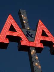
A&A Appliance
8294 Folsom Blvd.
Sac City Ink
Housed in an old brick building.
Junction with CA-16
Folsom Boulevard swings around a bit here, and then closely parallels the railroad tracks for several miles into Folsom. This grade was originally selected for the Sacramento Valley Railroad, which started construction in Sacramento in 1852, and reached Folsom in 1856. Now the Sacramento Regional Transit lightrail runs this route. See this history of the Placerville and Sacramento Valley Railroad.
8329 Folsom Blvd.
Park N Gas
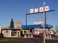
An old Texaco station.
8475 Folsom Blvd.
Crazy Tacos
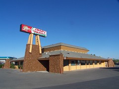
It was Brawley's Coffee Shop from at least 1970-1990, although I don't know if it was originally that.
8545 Folsom Blvd.
Bamboo Tree Mobile Park

8581 Folsom Blvd.
Tahsoe Motel & Coffee Shop
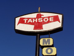
It has been a while since the coffee shop was open, but the motel was still around in 2007, and was demolished late that year. I don't know what the name is in reference to.
8637 Folsom Blvd.
Stardust Motel

It's harder for me to research businesses farther out than this, as we are now moving out of range of the earlier city limits
9509 Folsom Blvd.
Casa Linda Motel
9515 Folsom Blvd.
Vince's Motel
Welcome to Rancho Cordova

There are some interesting historic artifacts in Rancho Cordova, like the Kilgore Cemetery, but the vast majority of this city is of very recent origin. A post office didn't open up here until 1955, and the city was not incorporated until 2003. It consists largely of corporate campuses, strip malls, and suburban housing. The city has massive plans for growth, so I'm sure it will get even uglier than it already is.
9878 Folsom Blvd.
Routier Station

Long Exposure at Night of the Front
This is the historic railroad station on the Sacramento Valley Railroad line known as Routier Station. It dates from 1860, and of late has been uses as an office for Pfingst Realty Company. It's a neglected relic--despite the fact that I used to drive by it on the way to work and meant to photograph it, it took me 4 years to get around to doing so, and I can't find any other photos of it on Flickr.

Long Exposure at Night of the Back
10115 Folsom Blvd.
Old Mills Winery Office Park
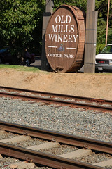
Being the clever sleuth that I am, I have deduced from the name of this business park and the part of a wine cask used for its sign that a winery once operated at this location, but I haven't found any information on it yet.
10121 Folsom Blvd.
Walker Cordova Hardware
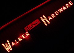
10153 Folsom Blvd.
Wienerschnitzel

In the classic A-frame building, now demolished.
10271 Folsom Blvd.
1st Value Inn
Formerly a Motel 6.
10273 Folsom Blvd.
Rosie's Country Kitchen
Formerly a Denny's.
10701 Folsom Blvd.
Cordova Lodge/Inn

Cordova Lodge, is what it originally was. After a series of other names, it now has one that is simliar, the Cordova Inn. I would guess that it was built around the time that the post office opened (1955). The "Restaurant" sign on the side had been painted the same color as the building to blend in for years, since there is no longer an operating restaurant, but when I drove by recently I noticed it has been removed all together.
I hope to flesh this out some more in the future with more information and photos, and perhaps more entries, but for now, this is it.


