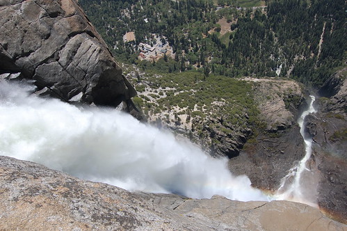
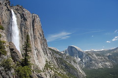
Yosemite Falls Overlook
I planned for this blog entry to cover all of my first visit to Yosemite National Park. When I told a friend at work that I would be going there for the first time, his response was, to the best of my memory, "What? You've never been to Yosemite? You, Mr. Hiker? Why are you going now, man? It's going to be 100 degrees this weekend. And Mother's Day to Memorial Day, that's like the busiest time at Yosemite."
Everything I had read said that the best time to go was in the spring before Memorial Day Weekend--in the spring to catch the waterfalls at full strength, and before Memorial Day to avoid the crowds. And the high temperatures to me just meant that there would be a lot of snow melting, and thus more water for the waterfalls. Anyhow, I had already paid for a camp site 23 miles outside of the park for Saturday night.
My plan was to take my time stopping to take photos along the way, since I couldn't check in at the campground until 1 p.m. I wanted to be there exactly at that time, so as to get into Yosemite as quickly as possible and maximize my time there, and I came close to doing that, arriving at the campground at 1:15. And then everything went downhill from there.
I had planned to get in a good hike that afternoon, do a bigger hike Sunday morning, and then catch several of the short and quick attractions Sunday afternoon before leaving. But Saturday ended up being just a day of frustration for me, it taking far longer to get into the park than I expected, and Yosemite Valley being one big traffic jam when I got there. I parked in the wrong spot, found a bridge I was planning to cross was no longer there, and eventually had to give up on the idea of getting my first hike in. Then I dealt with parking lots, campgrounds, visitor centers, concessions, worker housing, and heavy traffic all day. At one point I thought the only photo I would have for the day was of an insane man directing traffic, who alternated between telling people who couldn't hear him behind their rolled-up windows, "I can't drive the car for you. I don't know where you're going," and gesturing to vehicles that existed only in his imagination to proceed through the intersection, while holding up huge lines of people and cars coming from other directions (he was in an official capacity, and had two helpers, who were completely spaced out).
My favorite photo from day 1 in Yosemite
But enough of my frustrations. I decided just to consider it an introduction of how to get around Yosemite Valley and what not to do, and prepare myself for at least one long hike the next day. I studied the literature I had been given at the gate and got ready to do everything exactly as they recommended.
I got up at 6:15 the next morning, and headed out from my campground after showering and packing up the tent at 6:50. I ate a leftover half of a turkey sandwich from the day before for breakfast while driving. Taking CA 140 into the park, I had to wait at a stoplight where it said to expect 15 minute delays. The road was buried by a rock slide here, and they were diverting traffic on temporary bridges to the other side of the Merced River onto a one-lane road into order to bypass the buried section of highway. I didn't have to wait a full 15 minutes.
Then it was into the park, where a section of road being worked also required traffic coming each direction to take turns, only here the sign said to expect 30 minute waits. The 4 times I passed through there on my trip I never had to wait nearly that long. It's like my mechanic, who always gives me a higher estimate than what the repair work turns out to cost so I can then say, "Well, at least it's not as bad as it could have been."
Then it was onto Southside Drive, which my map shows as one-way, but apparently was temporarily two-way. I went to the day use parking area, as directed, near Yosemite Village. From there, stop #1, I took the free shuttle bus to Camp 4 Walk In, stop #7, arriving about 8:35, an hour and 45 minutes after leaving the campground. From an ugly utilitarian area, I walked across the road to the parking lot for the walk-in campground, found an east-west trail behind it, and headed west to the trailhead for Upper Yosemite Falls Trail, between the parking lot and the campground.
And then I started to climb. It's nonstop switchback for a long time on this trail. Four younger and more slender men soon passed me, although I was going all out, and before too long they were out of sight and earshot. The trail here is a lot of dirt and sand piled atop a foundation made of granite rocks, and there are many oak trees and chaparral.
I was breathing heavily and sweating heavily, although it was still early in the day. After a while I came close to the young men who had passed me, who were pausing. One of them commented on how the back of his shirt was soaked with sweat, as mine was. Another saw me, and, surprised that I had nearly caught up with them, commented that I must be trying to come after them to sell them insurance.
I realized at this point that I needed to pace myself better, and that I had no business keeping up with the fit and cruelly mocking youths ahead of me. At this pace, I was going to run out of water quickly, so I took a rest, and then started on again at a slower pace.
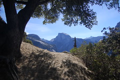
One of my first views of Half Dome from the trail
At one point there is a guard rail on an outcropping just off trail, called Columbia Point, I think. Or that name may refer to a point reached on an unsigned spur trail that was not marked on my map and that I didn't follow. This point, anyhow, offers fine views in both directions of Yosemite Valley. For some people this is the end of the hike. But there's not a lot more climbing left on the initial section of trail after this to reach views of Upper Yosemite Falls..
After climbing some more, the trail starts downhill--surprisingly so. I remember reading in the trail description from a book that it was a surprising descent, but even having been prepared by the reading that, I still found myself surprised by the extent of the descent. After all, I had a long climb left ahead of me to the top of the waterfall, and not only did this mean I had lost some of the elevation I had gained earlier, but it meant I would have to be climbing this portion of trail on the way back.
At the end of the descent are fine views of Upper Yosemite Falls from the same altitude as its base. There's also an unsigned spur trail here that was not marked on my map, but that is referred to by Leon Turnbull on waterfallswest.com as "Oh My Gosh" point, where one has a fine view of the upper falls, middle falls, and the top of the lower falls. Unfortunately, I did not read that description until I got home from my trip, and I did not take that spur trail.
After this, the real fun begins. I began climbing switchbacks again, only this time more steeply. Here there was not nearly so much dirt--I was stepping either on bare granite rocks, or rocks covered with a fine coat of granitic dust, making the footing difficult. This area is a crevice between two sheer granite walls where enough boulders, rocks, and dirt have accumulated that trees can grow there, and a steep trail could be constructed, although you can see from the semi-circular shafts on the edges of many large chunks of granite that the team that built the trail had to split a lot of rocks and do a lot of rearranging.
This was just a monster of a climb, made more challenging by the fact that it was starting to heat up, and there was rarely shade. Anytime there was an area of shade large enough for two people to sit under, there were two hikers or more sitting under it. After climbing a good long time I would look up in disbelief at how much farther I had to go to get to the top.
"It's just a matter of persistence," I thought, and knew I would make it, but I did want to get to Yosemite Point in time to shoot the valley to the west in morning, or at least midday, light. I wasn't thinking of getting lighting for the valley to the west then, figuring I'd already be done with this hike by afternoon, and looking to get those shots from Mirror Lake or Tunnel View.
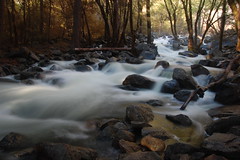
But it was all taking much longer than I expected. I finally reached the top, and followed the sign for Yosemite Point. And immediately I got lost. I was walking across use trails, but they were just connecting various areas used for campsites, a couple with fire rings. I knew I had to cross Yosemite Creek in order to get to Yosemite Point, and I was hoping there was a bridge. So I went to the creek and went up and down it a ways, which meant climbing and scrambling--the sort of additional work I didn't want to be doing on this hike. Finally I spotted a father and daughter I had seen a few times before on the trail walking away from me. I followed them and soon spotted the bridge and a granite stairway leading down to it.
Yosemite Creek from the bridge
After crossing the bridge, I found myself in a familiar looking territory. It reminded me of one of my two favorite places on earth, the Desolation Wilderness in El Dorado National Forest (the other being Point Reyes). Large swaths of smooth granite occasionally rising to bare peaks were lightly sprinkled with hardy confers.
I had no problem following the trail out to Yosemite Point, 2936 feet above the trailhead. There I had splendid views in both directions, if not particularly good lighting either way. On reading up later, I found I should have also been looking for a freestanding shaft of granite from there called Lost Arrow Spire.
It wasn't all return from that point. I was easily able to follow the trail back across the creek to the spur to the Upper Yosemite Falls Overlook. I hiked south towards the edge of the cliff, and then started down--descending far more than I would have liked to on my tired legs. Just before the overlook I stopped and thought, "You have got to be kidding me!" I had been on a rough and steep stairway carved of the rock with a railing anchored into the granite. Now I got to a very narrow stairway in which there was not enough room to anchor a railing, so one had been put into the wall of granite on the other side--it was there for you to hold onto, but it wouldn't catch you from falling. I slowly and cautiously made my way down.
There's a large flat area there with a guard rail anchored into the granite from which to see what you can of the falls. Earlier tourists got a better view, as I could see where the guard rail used to be anchored--much closer to the edge. The best I could do was to lean over the rail, stick out my camera, and take a photo in the general direction I wanted, then immediately check to see how the faming came out (see the picture at the start of this entry).
Then I started back up. Not only did I go slowly and cautiously, I stopped to rest, even on this short (but steep) ascent. I was hot and tired, and trying to ration my water. Oh, and I didn't bring any food on the hike either. I thought I would be done early enough for a late lunch from one of the park vendors.
Back up on the main trail, I tried to figure out where I had gotten off it in the first place. It was easy enough to find--the trail is completely clear with large rocks set out on either side except for one point as you are heading out on the trail where it makes a sharp right without any indication. Once you turn right you can easily see the trail you are supposed to follow, but if you continue straight, you'll be off trail as I was on the way out. But it was easy to find my way back on the return.
I got back to a small creek that flows down the crevice, choosing to make its way down to the valley floor via very small steps, rather than the enormous plunge of the raging waters of Yosemite Creek. People were there liberally dousing themselves with the cold water to beat the heat, and I did the same. I was trying to save my last bit of drinking water for immediately after the last portion of climbing.
I started down the trail in sunshine, now without the spots that were shaded in the morning. I could feel it in my left knee soon. Getting your footing is more difficult on the descent than the ascent, so I was working extra hard. I slipped several times, but always manged to keep my balance. One time, though, I did managed to bash my right knee into a rock, for a cut and a bruise.
I've never taken so many stops to rest on a hike as I did this one, and certainly nowhere near so many on the way down. I passed people and had people pass me heading down, and, of course, I encountered many people coming the opposite direction. I had been this miserable on a trail before--an easy trail at that, Stevens Trail (less than 1/3 of the climbing on this trail), when I was first beginning to hike, was out of shape, didn't pace myself, and had an inadequate water supply. But I've never seen so many other hikers look so exhausted and overheated. It hit at least the mid 90s that day.
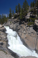
Finally I decided I had to take one good long rest. I got next to a sheer granite wall that had just begin to offer some shade off the trail--minutes earlier that area had been in direct sunshine, and the rocks I was sitting on were hot. I just hung out and let evaporation do what it could to cool me down. People hiking by in both directions all stopped for at least a few seconds in the shade, and some stayed longer. This spot also had a nice view of the valley and Half Dome, although there are better views on the trail. As I sat there, the shade kept extending, and soon covered the portion of trail next to my spot.
View of Upper Yosemite Falls & Half Dome on my way down
And then I started down again. I passed through the low area nearest the falls, close enough to get some refreshing spray. After that I climbed up that surprising portion from earlier, my last bit of climbing on the hike. Once I was started downhill again, I looked for a shady spot to stop and take out my canteen and get every last drop out of it.
Back on the sandy initial portion of trail, I had quite a bit more shade, but I still found myself resting frequently, and wondering about people just starting their way up--as I was nearly all the way down there was a group of kids starting up, some of whom just had sodas from a fountain with them with plastic lids and straws, and were wearing jeans of all things. It shouldn't have taken them long to become miserable.
Once back to the trailhead I went straight to the campground and used the drinking fountain to fill up, myself first, and then my canteen, with water. I slowly trudged to the shuttle stop, seeing a shuttle pull away just in front of me, to wait, all the while drinking more water and feeling better. When the shuttle came, the air conditioning was a splendid relief too. I went back to the car and changed out of my hiking boots into sandals, and put on a fresh shirt. I then headed to a grill for a lousy cheese burger, but, more importantly, a huge lemonade with lots of ice.
I had just been planning to call it quits and drive home after that, but after cooling off and rehydrating, I felt fine. So I did some more running around--all on flat land, before leaving the park. The day after I was out walking a few times, and had no problem on flat land, but was quite sore going up and down the stairs to my apartment.
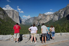
Visiting oft-photographed Tunnel View after the hike
Back at the shuttle stop at Camp 4 just after the hike had ended, and older couple had commented on how exhausted I looked. I told them about the hike I had undertaken, how hot it had been, and how I hadn't had enough water with me. They asked me, "Was it worth it?" I immediately responded without even thinking about it, "Oh yeah." My discomfort was only temporary, and even though I didn't see everything I should have, I saw plenty to impress me. This experience will help me to have an easier time of it, and get more out of it, next time out, and I'm sure there will be a next time on Upper Yosemite Falls Trail. Finally, it's more of what I came to Yosemite for than parking lots, visitor centers, and gift shops. I'd much rather be faced with a difficult climb than be stuck in traffic.
1 comment:
Hey, I myself am a big fan of Yosemite. I go there once a year. I have also done the hike to Upper Yosemite Falls and I must say that it is absolutelly stunning from the top, but if you want somthing that is a real challenge, I might suggest Half Dome. Im not exactly sure on the total milage of that hike. I think it is somewhere around 15 or 16 miles round trip from Yosemite Valley. It is definately the most strenuous hike in the park. If you thought those trails on Yosemite falls were steep and narrow, you should see the trail to half dome. It is definately worth the work once you get to the top though. It is just amazing up there. I go to Yosemite alot and am very familiar with most of the trails. If you have any questions you can contact me at: c_jsather@hotmail.com
Post a Comment