When I last went hiking with my friend Erik, I did little to prepare myself. This time, I did even less preparation. I didn't even get directions to the trailhead. I just grabbed California Hiking on the way out the door.
I was running late, but thought I still might make it on time to pick up Erik--until I stepped out the door, and saw frost all over my car. I was 5 minutes late, and Erik was already standing outside when I got to his apartment. I quickly cleared everything off the passenger seat for him and handed him the book, and we were on our way.
I had hiked to Feather Falls once before, so I didn't expect any trouble, despite my lack of preparation. We headed up the Central Valley on I-5, then CA 99, then CA 70 to Oroville. From there I needed the directions in the book. We headed east into the foothills, and passed by Lake Oroville, which looked like it was nearly empty.
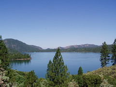
Lake Oroville in July of 2006
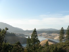
Lake Oroville in January of 2008
At the trailhead/campground, there were just a couple of cars--quite in contrast to when I hiked this trail in 2006, but that was in July. It was crowded then. There's a good reason so many fewer people were there that day--it was cold. I put on a knit hat, and packed a second jacket in my backpack, just in case.
We headed off on the trail, which only goes a short ways before dividing. Either way you go you will meet up with the other spur for the last short climb to the Feather Falls overlook area. One way is shorter, 3.3 miles, but has greater elevation changes. The other way is more gradual, and about 4.5 miles. Both are more downhill than uphill on the way out. In 2006, I chose the shorter way out, and then hiked back up on the more gradual route. This time we went the opposite way, just so I could have some variety.
Since it was summer when I hiked the trail in 2006, I had the chance to see more plant and animal life then.
2006 Photos
This time we didn't hear much for birds, or see any lizards. But we often had the sound of a creek . . . or me talking about old highways, or Erik talking about politics.
While it's the Feather Falls Trail, there are more waterfalls along the route. There's one sizable one on the longer route, with a bridge across the creek just below it, the perfect place to take a picture. I don't know if the waterfall has a name, but I believe it is on Frey Creek.
Not long after that we joined the other spur, and started a fairly steep climb, then a very brief descent. With massive Feather Falls in sight through the trees, the trail reaches a junction. One way does a U-turn, and is signed for the overlook. The other way is unsigned, and is not shown on the map at the trailhead.
We took this other route. In 2006 I went the other way first, and from the overlook could see people sun bathing on rocks just above the falls, and saw a chained link fence securing an area just at the edge of the cliff. I went the other way to try and get down to that area, and couldn't find it. This time I hoped for better results.
The trail leads over initially to an area just above the Fall River. It was easy to spot the use trail down to that area this time, but it was faint, and would be harder to find in summer with bushes in full foliage.
The trail over to the general area is an official trail, and continues a long ways past Feather Falls. But the several little use trails down to Fall River are not official. This is a dangerous area, as several people have been swept over the falls to their deaths. We saw a man jump across the river here, and jump back. But in 1967, a young boy jumped to a rock in the river, slipped, fell into the river, and was swept over the falls.
We were far more cautious than the man who jumped across--there's no better view over there anyhow, so it's certainly not worth the risk. We slowly worked our way over to the fenced off area. This is right at the edge of the falls, and it is a nice view down. In order to get a photo without the chainlink in it, I had to just hold my camera above the fence and shoot down. The results were disappointing. The lower part of the falls and the canyon below were all in shade, so the image just shows white water flowing into darkness. It looks as though it could be a 5 foot drop, when it is actually a 640 foot drop. Yes, 640 feet, making it the sixth largest waterfall in the United States.
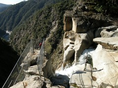
Erik on the Precipice
After leaving the fenced off area, I climb up above it, in search of more views, while Erik took photos from where I had just been. A couple arrived at this time, and waited for Erik to finish so they could have their turn.
Leaving the falls, we went farther upriver along the trail, just to see where it led. It parallels Fall River, with many more use trails down to the water, with some spots looking like nice campsites. Certainly somebody camped where we finally stopped and turned around, as there was a fire ring and an iron frying pan--as well as boots and jeans and various other garments that had been abandoned.
We took some pictures of the river here, then returned to the junction, and this time headed out to the overlook. The overlook itself is a substantial structure built on a rocky outcropping with a full view of the waterfall. There were quite a few people here, coming and going. Several couples handed over their cameras to strangers to get pictures of themselves in front of the falls.
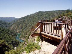
The Overlook
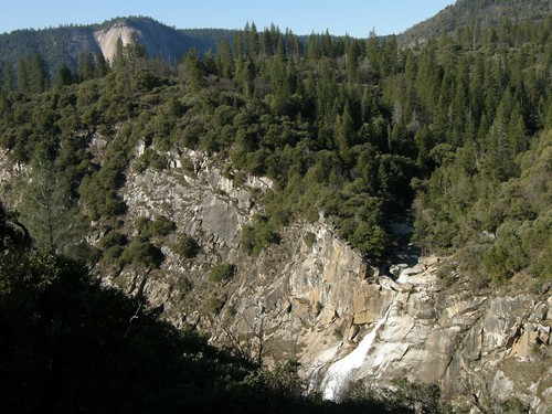
Feather Falls
This video should give you a sense of scale:
Feather Falls from tspauld on Vimeo.
There is also a nice view down the canyon in the opposite direction. When I was there in 2006, I could see boats that had come up Lake Oroville, all the way to the point at which Fall River empties into Middle Fork Feather River. This time, that area had large rocks exposed by the low water level.
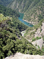
Lake Oroville Boats
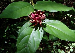
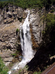
After eating our lunches and enjoying some of the warm sunshine at the overlook, we headed back. As we made the short climb away from overlook and were about to start down again, I noticed a trail leading uphill to the west. We decided to follow that to see if there were any more interesting views of the falls from up there. We got up to a campsite, then followed an overgrown trail a short ways to another, more clear trail. We continued on, catching glimpses of the falls through the trees. Eventually we got away from the sound of the waterfall, and realized if there were any more views, we would have to hike a long ways for them, so we turned around. At one point on the way back we went down the slope off trail a ways to where there was a less obstructed view (the picture at the top of this blog entry).
We got back onto the main trail, and quickly down to the fork, where we took the shorter route this time. The longer route had a view of it as well, but the shorter trail has a better point from which to view impressive Bald Rock Dome, with a sign explaining how it was formed.
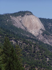
Bald Rock Dome
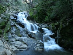
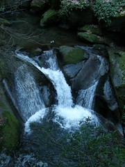
Although it has more ups and downs, we could have sped back to the car on the shorter trail, but instead took another diversion. This trail runs above Frey Creek for much of the way, and crosses it. Before we reached the crossing, we spotted another nice waterfall through the trees. There was evidence of where people had climbed down the steep slope for an unobstructed view. I asked Erik, and he was all in favor of doing the same.
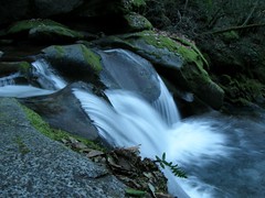
We had to scramble a bit, using our hands, sliding on our asses, but it was quite a lovely little waterfall. After taking some long exposures--using my backpack in place of the Gorilla Pod I had stupidly left in the car--I headed back up, while Erik continued to take pictures. But up at the trail again, I spotted another area part way down that looked like it had a nice overview, so I went there to take some shots. I showed one of the pictures to Erik once he climbed back up to the trail, and he decided to head back down to the same place.
The last stop we made on the way back was at a sign in front of some large boulders with mortars in them carved out by the Maidu.
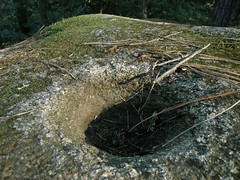
Maidu Mortar
With all of the diversions, it was probably about 10 miles of hiking, and we were out there almost 5 1/2 hours. It was so nice to change out of my boots and back into my sneakers back at the car. We continued to take our time on the drive home. We stopped at an old drive-in restaurant in Oroville, where I had a splendid burger, and I pulled off the highway to show Erik around the interesting old downtown area in Marysville. What had started out in a frantic rush in the morning turned out to be a relaxing and enjoyable day.
4 comments:
Great post as always Tom! Great side-by-side views of the receding lake. I read on the news that the low water levels have been exposing sunken cars that have been dumped there.
Another interesting account. Love the video.
Great post and details. I am planning to visit this place :)
To elaborate on what Stuart said, not only have sunken vehicles been exposed by the low water levels, but also human bodies. Some guy jumped off the bridge over the lake and they were finally able to recover his remains after the water level dropped enough.
Post a Comment