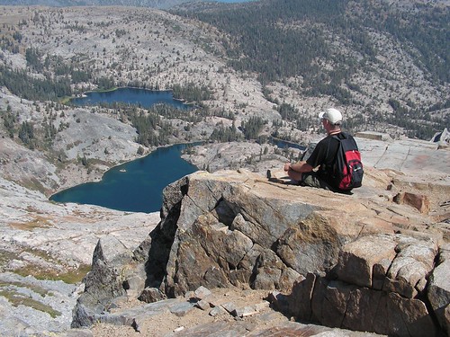
Erik's Shot of Me on Ralston Peak
Had I known what a spectacular overview of the lakes of the Tahoe Sierra this peak afforded, I would have hiked it earlier. Instead, I waited until I had run out of other ideas for hikes with nearby trailheads that lead into the Desolation Wilderness, and then chose to hike this trail out of convenience. My friend Erik joined me again.
The parking lot for this trail is just off of U.S. Route 50 to the north, shortly after (when headed east) Twin Bridges and Horsetail Falls, just before the final climb to the pass before dropping down into the Lake Tahoe region. A sign nearby indicates the area is Camp Sacramento.
From the parking lot, we hiked up a dirt road that curves around past a cabin and then to the signed trailhead where there were Desolation Wilderness permits available. After filling one out, we started into the forest.
For 45 minutes we hiked up a moderate grade on a dirt trail with few rocky sections. The grade was easy on our legs, and the dirt was easy on our feet. But eventually I knew things would get difficult, as it is a 2800-foot climb to the top of Ralston Peak, accomplished in only 4 miles. At the end of that 45-minute stretch, we hit the steep portion.
The next 30 minutes was slow going leaving us short of breath as we plodded on the overly steep trail wondering why there weren't more switchbacks. When we reached a ridge with a dramatic view of Pyramid Peak off to the west, we got some relief, as the trail took us on moderate ups and downs. But this respite was short-lived, and soon we hit another steep stretch. This second difficult portion proved to be much shorter, however, taking only about 10 minutes. From there to the high point of the official trail, our climb varied back and forth between moderate and steep as we passed through an area where the trees were more sparse. This would probably be a nice wildflower area earlier in the season.
At the high point there were large and obvious cairns off to the east of the trail, and a clear use trail beyond them. The trail up to the peak is not official and is not maintained by the forest service, but there were plenty of cairns left by other hikers to suggest a route, and the terrain was not difficult, being not all that steep, only sparsely sprinkled with trees, and with lots of dirt rather than jagged boulders to cross.
We followed along from one cairn to the next until we came to a large amount of talus right at the peak. I wasn't sure if we should just climb straight across that to the highest point, or continue along the dirt to the south of it and find an easier path up. I tried the latter, with Erik following. We soon came to a ridge with dramatic views of Echo Lakes, Fallen Leaf Lake, and Lake Tahoe. Climbing up the spine of this ridge, we eventually had to clamber across piles of talus anyhow on the way to the summit.
At the summit, the view is spectacular, although it was marred that day by all the smoke in the air from the Plumas fire. There is the aforementioned view of major lakes off to the east. At the foot of Ralston Peak directly to the north--close enough to give me the urge to hike down to them for a swim--lie Tamarack, Ralston, and Cagwin Lakes. In the distance to the north lie Mt. Tallac, Gilmore Lake, and Susie Lake. Off to the west is Pyramid Peak, looking more like a pyramid than it does from any other direction I have viewed it. Visible below that to the north and east are vast Lake Aloha, Lake of the Woods, and a couple other lakes of the dozen or so small ones south of Lake Aloha.
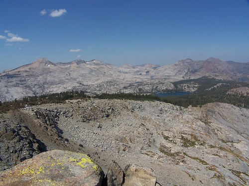
Pyramid Peak, Lake Aloha, & Lake of the Woods
Actually, there wasn't so much a Lake Aloha to see on the day we were there, as there was a series of small lakes. Originally, that was what was there--the Medley Lakes. But in 1875, a dam was built, and in 1917 it was raised, creating the inexplicably named Lake Aloha. Late in the year, water is released from the dam to feed lower lakes, Pyramid Creek, and the South Fork American River, and ultimately Sacramento. Only instead of bare granite, or trees, grasses, and wildflowers springing up in any foothold they can find in between the Medley Lakes, now when the water recedes we are left with large expanses of cracked, dried mud.
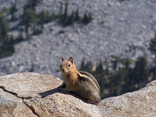
It still looked lovely from our distance. I broke out the binoculars my father gave me for Christmas and found the trail up Mt. Tallac, and boats in lower Echo Lake, Fallen Leaf Lake, and Lake Tahoe. We also took pictures of the abundant golden-mantled ground squirrels. Just like the ones we experienced on the summit of Mt. Tallac, they were aggressive and would climb across us in search of food we brought along.
When it was time to head back, we just went directly across the talus the short way, rather than how we had come. There were a few cairns and a patch of trail on the other side of the talus as we started back, but the trail soon disappeared, and I wasn't seeing cairns as we had on the way up. After some time I checked my map and compass.
My Desolation Wilderness map is not always accurate. Although this is not an official trail, the map did show a trail to the peak. However, the trail it shows branches off of the main trail farther north than where we left the main trail, and then goes southeast to the peak. We were heading mostly east and a little bit south, so I figured we needed to go more to the north to follow the trail shown on the map back to the official route.
Soon enough we saw some hikers coming along the main trail, and found it, although not at the same point we had left it originally. I thought we were farther down the trail to the south, but instead, we were north of the point we had branched off before, as I realized when we started climbing, rather than descending the whole way.
We got back to that point, and then it was steeply downhill from there. Going steeply downhill can be slow going, but since it wasn't a rocky trail, we made excellent time. We made it back to the car by 2:30, whereas on the last hike we did together we made it back to the car at 7:00.
It's definitely a hike to repeat, particularly since the smoke didn't let us experience in its full glory. I'd also like to try it when the water level of Lake Aloha is higher, and there is more snow on the surrounding peaks.
3 comments:
thats such a cute squirrel...hehehe
thats such a cute squirrel...hehehe
I climbed Ralston Peak about four years ago. And, although the view from the summit is GREAT, that's about all I enjoyed about the hike. As was mentioned here, the trail is just overly steep. I seriously don't know what the makers of this trail had against switchbacks. But it just seems like the forest service decided to turn a use trail into an official trail without doing any improvements.
Now all of this would be forgivable if it was a REALLY scenic hike. But it isn't. Much of the hike is simply through woods, with few views. Furthermore, you can forget about alpine lakes or streams along this hike. And unlike, say, the Carson Pass Area (which I MUCH prefer to Desolation Wilderness), you don't have much when it comes to wildflowers.
So all in all, I just didn't find the hike to be worth the effort. The way I see things, there are PLENTY of better hikes in the area when it comes to effort vs rewards. I would personally not hike this one again for anything other than training.
Post a Comment