But I don't separate them when I'm actually out exploring. I discover delightful signs and drive-in restaurants while going to and from hiking trips, and I plan camping trips as an excuse to explore new towns and highways. So for just this once, I'm going to present one of my excursions as a whole to give an idea to my family and friends (it amuses me to pretend that they read my blog) what they are like.
The only certain goal of this overnight trip was Mono Lake. I had heard much about this area in the Eastern Sierra from my friends Erik, Darla, and Dave, and had read fascinating accounts of the lake from Mark Twain and John Muir. I had a number of other places I wanted to visit in this area in mind: the site of the Japanese interment camp at Manzanar, the old ghost town of Bodie, Devil's Postpile National Monument, and the Alabama Hills. Plus, I planned to return through Yosemite National Park and get in a hike there, and stop off in Modesto in the hopes of photographing the State Theatre at night.
That was an overly ambitious agenda for an overnight trip, and I made things more difficult by not preparing well. I did little research, and I put off errands, like paying bills, until the morning I was leaving, meaning I got started three hours later than planned.
I could have rushed, and tried to skip less important things. But this was not a paid tour with a specific agenda and stops at all the must-see highlights. This was about me relaxing and having fun exploring what was out there and taking it as it comes. So starting off on US 50, the historic emigrant route and one of two routes for the first transcontinental road, the Lincoln Highway, I quickly stopped off in the boring suburban community of Cameron Park for lunch.
I love the historic gold mining towns of the foothills, but in between those and the city of Sacramento are these far outlying suburbs powered by the freeways and filled with the worst kind of suburban sprawl and generic chain stores and restaurants. But Cameron Park has one thing I had always been interested in stopping to check out, but never had: an old Eppie's restaurant, now 3 Brothers Restaurant. Eppie's was a regional chain out of Sacramento that started in 1964 and grew to 20 restaurants, but is now down to just one, and not the original one, in West Sacramento. Nothing particularly interesting about the interior of 3 Brothers, but the turkey melt special and potato salad were good.
Back on the road, I exited 50 at Sly Park Road, a familiar route to get to the hiking area of Carson Pass. Turning at the south end of the lake onto Mormon Emigrant Trail, I passed the lake, and then went through dense forest, which the highway was plopped down in the middle of. The squirrels have not adapted, and I call it "Squirrel Dodging Road."
The Mormon Emigrant Trail is named after a 19th century group of Mormons who came from Salt Lake City to help build Sutter's Mill, where gold would be found a year later. When finished, they returned to Salt Lake City via this route. Other place names in the area reflect their journey, like Tragedy Spring, where the bodies of advance scouts were found, having been slain by natives.
This route is a short cut to CA 88 and Carson Pass, rather than going to South Lake Tahoe, and starting down CA 89. Carson Pass is named after guide Kit Carson. There are two trailheads on either side of the highway here along the Pacific Crest Trail. I've made hikes from both trailheads.

Old Webster Schoolhouse, Markleeville
From here it was down into a broad valley to join up with CA 89 South and finally the start of new territory for me, the highlight of which would be Markleeville. Markleeville has a small park with a museum, the old jail, the old one-room schoolhouse, and some rusted machinery out back. I've seen the like all over Gold Country, but I still enjoy it.
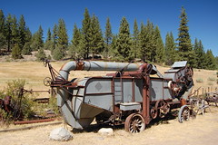
Old Machinery in Markleeville
After that it was over my second mountain pass of the day, Monitor Pass. This one had a nice stone marker placed there in 1959. Appropriately it was in front of a grove of aspen trees. I have never seen so many aspens in the Sierra as a I saw along this road--it must be wonderful in the fall.
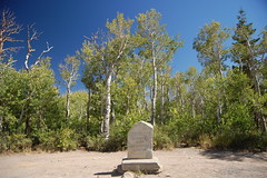
Monitor Pass Marker
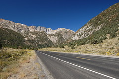
Once over Monitor Pass it is a steep descent with wide open views of a valley--wide open, but, unfortunately, hazy on this day. Snaking through a river canyon at the bottom, the CA 89 leads out into the valley and terminates at the junction with US 395.
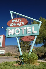
West Walker Motel
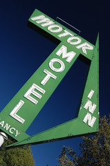
Now this initial portion of US 395 I had been on before on my way back from Sonora Pass and the Stanislaus National Forest, but that had been during a period of terrible wildfires when most all of California and eastern Nevada had smoky skies, so I did not stop for photos. On this day, it was just a bit hazy when looking to the east, but the polarizing filter generally took care of that. I stopped along the way to take pictures of old neon signs and roadside burger stands, particularly of well maintained, vintage motels in Walker.
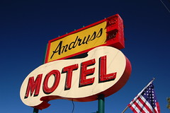
Andryss Motel, Walker
Passing the junction with CA 108, I was once again in virgin territory for me. Then I had the pleasure of pulling into Bridgeport--like Walker, with very well maintained vintage motels with neon signs, but considerably larger. I stopped to photograph the signs before continuing on.
On leaving Bridgeport, there was a sign indicating a portion of scenic highway was beginning. The highlight of this is an overlook on a sweeping curve as the road starts descending to Mono Lake. There is a view of the whole valley, and the shriveled lake surrounded by salt and tufa. Of course I took the turnout.
Again, I hadn't done any research, so I wasn't sure where to best go to view Mono Lake and its famous tufa formations. I chose the first turn off, for a county park on the northwest side of the lake on Cemetery Road.
It's a nice little park for families, with a large lawn and playground for kids. There's a trail out to a boardwalk in the state reserve area. Walking down the boardwalk, there are signs indicating the old water level in different years, which is depressing. The water level has dropped precipitously because water from tributaries has been diverted so the good people of Los Angeles can water their lawns, wash their cars, and hold wet t-shirt contests.
Finally there is a viewing area with a bench from which I could see some of the lakes famous tufa formations, but not many, and at a distance. So I quickly returned to the car and Highway 395 and headed a little farther south.
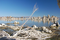
Soon there was another turnoff, just before the town of Lee Vining, which according to the map I am looking at now, is the old marina site. Here there were more plentiful tufa formations. Tufa is calcium carbonate, limestone, and is created when fresh spring water from underneath the lake rises up into the salty water of Mono lake and then accretions of limestone form into interesting shapes. They were exposed when the water level dropped. Mono Lake is much saltier than the ocean because it has no outlet--all of the salts brought in by fresh water remain there as the water gradually evaporates.
I took some photos there, but I was starting to lose the light. It was only 5 p.m., but this area is right close to high mountains rising to the west, and the sun was dipping below the peaks. So I decided to buy one of the pamphlets available there and plan my next move.
I saw that past the county park area on Cemetery Road I could drive out to a turnoff for Black Point, so that's where I headed. The paved part of the road ended at the Cemetery, and it was gravel road from there, but easy enough driving. I almost drove past the small sign low to the grand pointing to the turnoff for Black Point. That road was a little rougher, and there were various unmarked spurs off of it, which left me unsure if I was going the right way. But eventually I arrived at a parking area signed for Black Point.
It's a good walk across black, volcanic sand and rocks before reaching the white salt and limestone of the former lake bed. There were a lot more tufa formations here, backed by the black dome of one of the islands. And like the old marina site, there were millions of brine flies along the water's edge here. Mono Lake is a very important area for birds, particularly the species California gull (Larus californicus), the great majority of which next at Mono Lake. The islands provide safety from predators, and the lake provides abundant food in the form of brine flies and brine shrimp.
The falling level of the lake created a landbridge to Negit Island, and predators had access to the birds' nests, so they vacated the island. Luckily, a lawsuit against the city of Los Angeles finally resulted in a settlement in 1994 mandating a return to the 1961 level of the lake, well below the 1941 level, when water diversion first began, but considerably higher than it was then, or is still now. There is quite a ways to go before the water reaches that level, but Negit Island is once again and island.
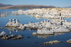
Mono Lake from Black Point
The light was great in the afternoon out there, but I was the only one around. Eventually I had to start thinking about where I was going to spend the night. My plan was to camp, and I wanted to get my tent set up before dark.
But for a variety or reasons, I ended up returning to Bridgeport and staying at the Silver Maple Motel, one of those beautifully maintained old motels with a lovely sign. I had dinner at the equally wonderful Sportsman's Inn. This place has knotty pine paneled walls, large booths, and an old counter. For a very reasonable price I got the rainbow trout dinner, which came with soup, salad, rolls, French fries, and coleslaw. Sure, there were some brown spots in the lettuce, and the fries were overcooked, but the trout and chicken rice soup were excellent and the service was attentive.

They had 4 beers on tap listed on the menu: 3 premium beers for $4 a pint, and Pabst Blue Ribbon for $2.50. But I found out later that it is only $2 a pint in the bar, where you can also get a "spaghetti hot dog with Swiss cheese" for $3.50--undoubtedly a culinary adventure. After photographing neon at night and setting up my tripod to get a long exposure of the courthouse, I added a few gallons of gas to my tank to make sure I'd be able to make it to the Central Valley without having to buy more gas. While beer is cheap in this high desert town, gas is expensive--nearly $5 a gallon, while it was only $3.69 back in Sacramento.
I shot the neon signs of Bridgeport at night after that, and got a long exposure of the Mono County Courthouse before heading back to my motel room.
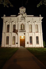
Mono County Courthouse
Had I been in my sleeping bag in a tent, I would have had no problem getting up at 6 a.m. to shoot the tufa towers of Mono Lake at sunrise, as I had planned, but in the comfort of my bed, I overslept, and got up at 6:45, and I still had to drive 20 miles back to the lake. All of the great photos I have seen of Mono Lake are in dramatic lighting conditions--sunrise, sunset, or in stormy weather.
I had to settle for good light, not dramatic light. I drove south of Lee Vining to the turnoff for CA 120 east. On that road I drove past Panum crater, which would have made an interesting stop if the sun were higher in the sky (so it could reach the interior of the crater). From 120 it is a short trip on a gravel road to the South Tufa Area.
The South Tufa Area is a fee site, $3 per person, but they accept the federal interagency pass, so I didn't have to pay. Unlike at Black Point, there were already people at the South Tufa Area. I took the loop walk, starting to the west side, because the sun needed to move a little farther west in the sky before the formations on the east side would be lit properly. I worked my way east, reading all the posted signs and trying to find good compositions. I think a long lens would be your best bet for the photographing the tufa to compress the distance between the towers, but I don't have anything longer than 55mm at the moment, so I had to settle for that.
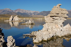
Mono Lake Tufa and the Eastern Sierra
Some time after I arrived a tour bus had dumped its load of tourists, and they were already returning to the bus by the time I was ready to leave. I started back to 395, but this time via gravel road close to the lake shore, instead of CA 120. I soon came to a turnoff to a parking lot a ways from another grouping of tufa towers. Initially I passed it by, but then changed my mind and backed up to it. I set off from the northwest corner of the lot towards the tufa. It was easy going at first, but eventually I had to fight my way through large bushes that scraped up my legs. But I made it to the tufa to take photos. I would have explored more along the shore there, but I got to a point where I was sinking into the mud--even though the water level of the lake has dropped, the springs that led to the formation of the tufa towers are still there, so there are lots of marshy areas.
When I was mapping my photos on Flickr when I got home, I saw from the satellite view that there appears to be a trail from the northeast corner, rather than the northwest, where I left from, that goes back to the South Tufa area, but there would have been little point in going back there.
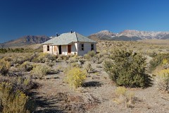
Returning to the car, I headed along the gravel road until I saw an old house that I had to stop and shoot. I would have liked to explore inside, but it was surrounded by a chainlink fence topped with barbed wire, so I decided to respect the message that fence was sending me, and just take a photo between the barbed wire.
I meant to continue all the way back to the old marina site on the gravel road, but instead of following the sign to the picnic area, I went the other way at a junction and was quickly back on 395. I see from the map that I missed one more major tufa area by doing this.
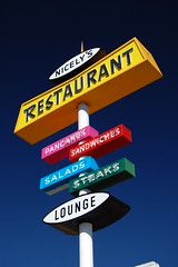
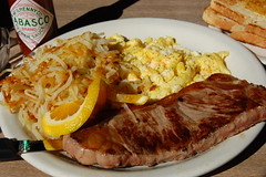
Back on 395, I returned to Lee Vining, where I parked outside of a closed drive-in restaurant, in the hopes that when I returned from walking around town taking photos, it would be open. But one of the signs I took a picture of was attached to a restaurant that seemed more appealing for breakfast--Nicely's, where I had steak and eggs--well done, even though I ordered the steak medium rare.
From Lee Vining I started my return to Sacramento through Yosemite National Park. That meant taking CA 120 west from 395: Tioga Pass Road.
Tioga Pass Road
It is a dramatically beautiful climb up this road into the high Sierra. I pulled over a couple of times to take photos, but had I been more quick to react, there were a couple of better spots to pull over. Climbing up a river canyon, I passed a large waterfall that was still going this late in the season, reminding me of how much higher the mountains are in this part than where I usually hike, the Tahoe Sierra. Soon after the waterfalls I reached a lake where there were many fishermen and even some motorboats--Tioga Lake, it turned out to be. And after that it was a long wait in line to get into Yosemite National Park--no charge, thanks to my interagency pass.
The plan was just to stop at a couple of obvious pullovers for quick photos, before reaching a trailhead for a substantial hike. So I stopped at Lambert Dome, where lots of people were lacing their boots, and getting out the ropes, and Tenaya Lake, where plenty of people were wading, swimming, and picnicking.
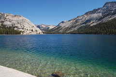
Tenaya Lake
Then it was Porcupine Creek Trialhead for my planned hike to North Dome. I headed down an old road .7 miles, crossed a couple of mostly dried up creek beds, passed through deep forest to a couple of junctions right after one another, all well signed, headed over along the side of a slope to a point where many people had obviously gone out to check the view, but a couple of unusually large cairns assured me the trail makes a sharp left. From there it was a pretty steep climb to a junction marked for the arch at Indian Rock.
It's a steep climb up to the arch via a use trail--it couldn't be a planned trail, despite the sign, as the park service would avoid such a direct ascent so as to prevent erosion. On the way up, I got my first views of famed Half Dome through the trees. According to California Hiking, the arch at Indian Rock is the only "natural bridge" in the park, although "bridge" seems to be an odd thing to call it, as it isn't really connecting two points across a chasm.
Back down on the main trail, I soon though I had come to my goal, but I was deceived. There was a granite dome directly ahead, with views of Half Dome, but the trail veered off to the left and down the steep side of a granite slope covered with decomposed granite, making footing a bit tricky. Down below, the trail turns back towards Yosemite Valley along a second granite dome--still not North Dome--and I was rewarded with outstanding views of Half Dome and immense masses of granite that I'm not familiar with enough to identify.
Well below and across a small forested ravine, I saw another granite dome sticking out. I could see people on it, so I figured that must be North Dome, and was surprised that my hiking book had not warned me what a long climb down it was at the end. I thought about not going any farther, as I had excellent views to the east, and the sun was in the wrong position to photograph Yosemite Valley to the west. It didn't seem as though the view I would get from North Dome would be so much better as to justify the extra effort. But thankfully I put those thoughts out of my head and kept on.
I reached a junction indicating it was .5 miles to North Dome, and started down a steep portion with tricky footing at points. I reached a large smooth section of sloping granite at which there were several other hikers. Two iron roads had been anchored into the granite here, and they were holding a rock in place, but I didn't really see how that was going to help me get down or back up again later. I asked to backpackers below how the rest of the trail was, and if there were any "slip and you die" spots. "No, this is the worst of it," they assured, "just a slip and you get hurt spot." So I slid down on my ass and kept going.
I passed though that small forested ravine and started climbing up the granite of North Dome itself. Just as I started a hiker coming the other way joked, "Nothing to see here. Go back." The winds whipped up as I headed out on North Dome. I could see Yosemite Valley below to the east, and of course, Half Dome looming in its immensity a short distance to the west. At the high point, I picked out the highest rock and climbed on top of it. Apparently I chose correctly, as the rock had a US Geological Survey marker embedded in it.

Half Dome from North Dome
I would have liked to have stayed there some time and watched the light change on Half Dome as the sun shifted in the sky, but I also wanted to get out of the mountains before dark, and I wasn't sure how long that would take, and get home to Sacramento that night. So I started back.
In the ravine the two backpackers who had reassured me earlier were setting up camp. Back at the tricky granite slope, I managed to get up on all fours--this time there was nobody else there, so I couldn't ask for a hand. I was really pushing myself to hike quickly, and I really wore myself out on this hike. At some point on the way back I realized I had been calculating wrong--I had set out at 12:45, not 11:45, so it took me 2 1/4 hours to make it out there, not 3 1/4. So I ended up getting back to the car at 5:05 when I had been worried about not getting back before 6:00. Despite being tired, I was able to get back more quickly because I didn't repeat the side trip to the arch at Indian Rock.
I drove out of the park and through the towns of Groveland and Big Oak Flat, after which comes a pretty amazing section of sharply twisting road with hairpin turn after hairpin turn. Since the road is taken by so many tourists to and from Yosemite who are not used to driving it, there is always somebody taking it extra cautiously and slowly to get stuck behind. I was fine with that, and enjoyed the road (I do like curves), but the red Jeep driver in front of me was really irritated, and even started to pass on one hairpin turn, before dropping back behind the lead car again.
From there I enjoyed the view of the beautiful golden foothills dotted with a surprisingly large number of dark green oak trees in the setting sun, and at one point I pulled over for a photograph.
Just after the sun set, a pickup driver flashed his headlights at me. I knew my left headlight was out. I had tried to replace it, but when I couldn't immediately figure out how to, I just threw the new bulb in the trunk and decided I would get it replaced when I had my oil changed. Only I forgot to mention it at the garage. But I didn't know why he would be flashing his lights at me for one headlight out, so I stopped at a gas station and discovered that neither light was working on low beam (although both worked on high beam). I had no choice but to sit there and figure out to install the new bulb. I took out 4 screws, only 2 of which needed to be out, before I figured it out, and got my hands very dirty in the process. The gas station was very busy with people streaming in and out, all ignoring me completely.
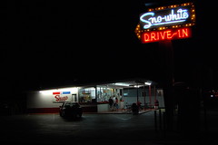
Tired and dirty, I was anxious to get home, but rather than taking the most direct route, I was in Oakdale on my way to Modesto because I have long wanted to photograph the State Theatre at night. I stopped off for a meal at an old Sno-White Drive In, then proceeded to Modesto to get the shots I was after although I was in a hurry and didn't do as good of a job as I would have liked, or take as many different takes on the subject as I normally would. There were some other neon signs I wanted to check in Modesto, but I decided to skip them, stopping impulsively only to photograph the Valli Motel sign just before Stockton on the way home on CA 99, formerly US 99E.
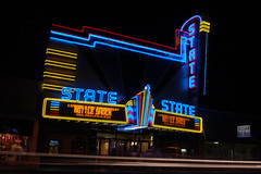
State Theatre, Long Exposure
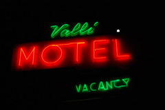
Valli Motel
I arrived home pretty late, which is always a mistake after I've been gone a while. The cat needs attention after being left alone, and he gets it, even if it means waking me up repeatedly all night long, which he did.
5 comments:
I enjoyed reading the description of the trip. Next time take the cat with you! =^)
A few years ago I got to spend a couple nights at Tenaya Lodge thanks to the school where my wife was working. Beautiful area.
Hey, loved your story on U.S. 395. I've done it many times. It's one of California's best kept secrets so don't tell anyone. The less people to come to this beautiful area, the better. One thing you forgot to check out though, is the Mobil station at Lee Vining. There is a restaurant inside that is of gourmet quality I kid you not. It was written up in the L A times in a very favorable article. I found out about it when I got stopped by the CHP for speeding north of Bridgeport. I asked the officer where a good place to eat was and he recommended the Mobil station. Now who in their right mind would eat at a Mobil station. I can't tell you anymore. You'll have to find out for yourself. It is seasonal though from opening sometime around May and closing around October.
Enjoy
I second that recommendation about the restaurant in the Mobile station at the 120 - 395 intersection. It's called the Whoa Nelly Deli. During the summer months they have a trapeze artist set up outside to entertain the customers. Everything I've tried there have been delicious, and the Fish Tacos with mango salsa and ginger slaw are amazing.
My two cats love to see me after a trip but fortunately they don't wake me up until it's time to be fed in the morning. I will be spending four nights in Bridgeport in just over a week. Can't believe I didn't take a slide of the courthouse.
Post a Comment