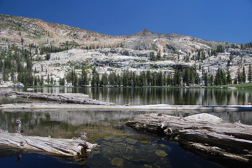
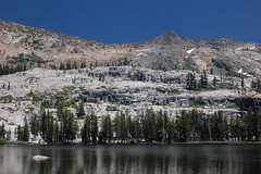
Lawrence Lake
Barrett and Lawrence Lakes are two fair-sized bodies of water set off by dramatic granite backdrops with a good mix of shady forest and sunny granite surrounding them, and are very close to one another. A hike to these two lakes from the Rockbound Pass trailhead at Wrights Lake would be a very good idea--I just wish that I can say it had been my idea the day my friend Erik and I visited them. But in truth, I was aiming for Pearl Lake, and missed by quite a bit.
In doing so, I ended up quite confused. I hiked to Pearl Lake last year. On that hike I had headed out (as we did this time) on the trail to Beauty Lake, then took a short jog over to a 4WD road, and crossed Jones Fork Silver Creek, all following the directions from The Tahoe Sierra. Last time I kept hiking on the jeep road, and eventually got worried that I seemed to be going the wrong direction and might have missed a fork described in the book. I hiked back to the creek without seeing any fork, so I turned around and retraced my steps until I saw a footpath leaving the road--one not shown on my map or mentioned in the book, and which I had not noticed the first time out. I followed it and reached jeep road again, and assumed that I had connected with the road I had taken earlier. There was a signed junction on this road with the trail up the short distance to Pearl Lake.
This time when we headed out I was prepared to take either that footpath or the road to the junction, as my memory was fuzzy on where I had spotted the footpath, and I wasn't sure I would spot again. We set out from the Rockbound Pass Trailhead, quickly came to Beauty Lake, and took the spur signed "JEEP TRAIL" over to what I believed was the Rupley Cabin Jeep Trail. On the jeep trail, we were passed by a couple of joggers, then spotted AquaFina water bottles strewn in the middle of the road as we hiked farther. Last year I had to cross Jones Fork Silver Creek with a difficult rock hop upstream from where the road goes through the creek. This year it was shallow enough that we just walked through it, as it widens out quite a bit at the road.
On the other side I spotted a coffee carafe off to the side of the road, and a burst balloon and streamer on the road--two of the more odd pieces of litter we would see all day. We hiked up alongside, but above, the stream, then crossed through alternating patches of forest and boulder-strewn granite. Seeing a third AquaFina water bottle off the side of the road, Erik set it on top of a rock so it would be easier for us to spot and pick up on the way back. When we climbed up into a forested area at one point I recognized it as being the area where the footpath left the road, and mentioned to Erik that we should be finding the trail soon.
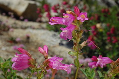
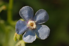
I spotted it on the left side of the road with no problem, and we headed off on that. Instead of a wide road, we were now on a narrow footpath surrounded by forest with patches of meadow. It was quite lush with ferns and wildflowers, but the moisture also meant there were plenty of mosquitoes. I didn't stop to take any pictures of the tremendous number of Henderson's shooting stars, or any of the other wildflowers, thinking we would pass this way on the way back.
Then a dilemma arose--we arrived at a fork in the trail. It seemed to me like last year I took the fork to the left, but I didn't remember for sure. If we went right we would be headed back in the direction of the road. I figured if that fork didn't lead to Pearl Lake, we could just continue on down the road to it. So we took the right fork, figuring it was the safer option.
This trail appear to be infrequently used, although there was one fresh set of tracks on it, visible wherever we crossed muddy portions. It was quite faint in places, although marked frequently with cairns and ribbons tied to tree branches. We started climbing immediately.
The amount of climbing was the first sign that we were going the wrong way, as I didn't remember doing much climbing last year on the way to Pearl Lake. But we got to a point where I recognized in the distance the slope of granite that runs behind Pearl Lake, which I had just been looking at a picture of in The Tahoe Sierra the day before. We were close enough that we could have easily gone cross country to the lake from there. But we kept following the trail.
The problem was, it wasn't heading towards that slope of granite. It was heading more to the east. It was a definite trail, though, and Erik expressed confidence that there would be some sort of lake at the end of it, so we kept going.
Finally we hit a junction sign, although it didn't exactly clarify where we were. It was labeled Rockbound Stock Drive Way, and had mileages for Lake Lois and Lake Schmidell. Once again I expressed concern, while Erik expressed optimism that we were headed somewhere interesting, even if we didn't know where. Just a few feet later we hit jeep road, and figured we would just continue on that to the junction with the Pearl Lake trail.
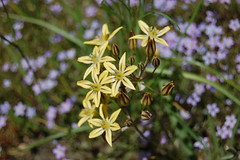
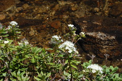
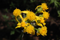
Golden Brodiaea
We hiked and hiked, passing patches of snow occasionally, which suggested we were higher than where I had planned to go. Finally we had hiked far too long to be on the way to Pearl Lake, but Erik thought we should continue. When we had to cross another stream, also Jones Fork Silver Creek, higher up, as it turns out, I again informed Erik that we couldn't possibly be headed towards Pearl Lake, and again he thought we should just find whatever lake was at the end of this trail, as he was pretty sure there would be one.
And there was--a large like with a heavily used camping area in front of it. There were rock fire rings built, one of which had a grill wedged into the rocks. There was stack of firewood ready to go. And, luckily, there was a couple up ahead, the first people we had seen since the joggers. I ran up and asked them where we were, and found out it was Lake Barrett. They pointed to a footpath leaving the clearing and told us Lawrence Lake was up that way, .2 miles of steep climb followed by .2 miles of easy hiking.

Barrett Lake
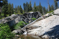
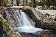
Creek Flowing into Barrett Lake
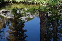
Reflection
Erik and I followed them and arrived at gorgeous Lawrence Lake, which is even larger than Barrett Lake, and just inside the boundary of the Desolation Wilderness (meaning you need to fill out a permit at the trailhead if you plan to visit it).
Lake Lawrence
I chatted with the female half of the couple while taking pictures there. They were in their sixties, and both had had back surgery. But they liked to go for 10-20 mile hikes and wanted to visit every lake in the Desolation Wilderness, even all of those off trail. She told me about several in the area, and Erik expressed interest in climbing up to one. But I knew we had hiked a long ways and frankly was already worried about Erik's stamina on the return.
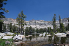
Barrett Lake

Instead we just returned to Barrett Lake. The woman had told me that the prettiest area there was around the lake's dam--most of these small mountain lakes have had small dams constructed to increase their holding capacity and regulate the flow of their outlet creeks. Below the dam was beautiful open granite area which Erik and I explored, and there was another lovely expanse on the other side of the outlet creek, so I leapt across, with Erik following me.
Barrett Lake Dam
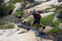
The Jump
On the Other Side of the Stream
After exploring that area, we started down the 4WD road. When we got that far back, I didn't notice the junction where we had joined the road from the footpath, but Erik pointed it out. I thought we should just take the road back, however, thinking both that it might be shorter, and that it should pass the turnoff for Pearl Lake, and so we could still squeeze that lake back into our hike.
We kept going and eventually got to an area that seemed familiar to me, which I mentioned to Erik, but given what I "knew" at the time, there was no way we could have gotten back to an early portion of the road I had been on before, either on this trip or on last year's, without having passed that sign for Pearl Lake. But farther down the trail, I spotted the AquaFina bottle Erik had set on the rock, and recognized a log covered with mushrooms I had seen earlier in the day. We were indeed back on the section of road we had been on earlier before we had gone off on the footpath.
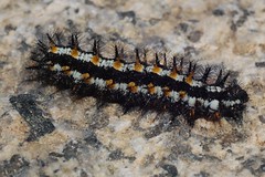
I stopped to take pictures of wildflowers and a fast-crawling caterpillar that Erik pointed out to me on the way back (a challenging subject with a manual-focus macro lens). But I couldn't stop for long, as the mosquitoes got worse as the afternoon went on. I had blood on my leg, cheek, and arm from slapping at them, and bites all over my calves. We also noticed bear tracks in many muddy portions of the road.
Erik started dragging on the latter portion of the hike, and reported afterwards that he was completely drained for the last hour. I had planned on a 9.4 mile hike with 490 feet of net elevation gain. Looking at maps afterwards I would guess that we hiked 13 miles with 840 feet of net elevation gain, plus some additional ups and downs.
My National Geographic Topo! mapping software and The Tahoe Sierra's hike description both agree that we were on Rupley Jeep Road running from Dark Lake to Rupley Cabin and the trail to Pearl Lake. But in looking at Tom Harrison's Desolation Wilderness Trail Map and the El Dorado National Forest website, we were on Barrett Lake Jeep Road. The road I joined last year after hiking on footpath does not come from Dark Lake or the Wrights Lake area, but comes in from the northwest and ends a short distance after the Rupley Cabin/Pearl Lake area. What's surprising (and Erik observed this as we were still on our return hike) is not that we missed Pearl Lake this year, but that I ever stumbled onto it last year. But these two lakes were more impressive anyhow, and we definitely got in a better workout.
4 comments:
We are on our way to Lawrence Lake, but will take Red Peak Trail from Van Vleck. I hope we have an easier time finding our destination! We figure about 6+ miles. Nice photos and article to help me prepare!
PeachyHiker.blogspot.com
Thank you for your posts on Lawrence Lake 10 years ago. and other post from 5 years ago. I just got the opportunity to Backpack to Lawrence Lake for the Evening. I took the Barrett Jeep Trail for about 7 miles. It took me a full day to drive and hike up to Lawrence Lake, mainly being out of shape. After almost giving up, I finally arrived at Lawrence lake around 7:30 pm Saturday evening, with plenty of sunlight. Cooked my meals, slept so well, no other people in sight. I had the whole beautiful lake to myself. I left at 10:30 the next morning to get home at a decent hour. Took Barrett Jeep Trail down again and it was much quicker for me since it was all down hill. The best parts were having the lake to myself, and bumping into all of the Jeep drivers. What a wonderful Weekend and thank you for sharing your experiences as well.
Any other suggestion from either of you in where a good backpacking trip in the area would be, I am open for suggestions. Especially if it is easier than the Barrett's Jeep Trail. I am still new to Backpacking and I am working on getting more into shape.
ซุปเปอร์ สล็อต สล็อตเป็นเกมที่มีความสนุกสนานและตื่นเต้นที่ไม่ต้องการทักทาย pg เนื่องจากมันไม่ต้องการทักทายทางการเดิมพันในสล็อต และไม่ต้องการมีกลยุทธ์เฉพาะเพื่อชนะในเกม
Post a Comment