In my first 11 years living in Northern California, I never made it to the dramatic coastline of Mendocino County, but I have learned the error of my ways, and made two camping trips there in the last year. The first was to Russian Gulch State Park, just north of the town of Mendocino on CA 1, the Shoreline Highway. This time I stayed at the sister park to that one, Van Damme State Park, just south of Mendocino on CA 1.
Last time I planned my own route, based on previous experience. This time I followed Google Map's suggestion for the quickest way there. I don't know if that route, down to Vallejo on I-80, over to Novato on CA 37, north on US 101 to Cloverdale, and then west to the Shoreline Highway on CA 128 was any faster, but it did take me through areas I hadn't previously explored. I took advantage of the opportunity and shot photos of vintage neon signs along the old US 101 route, pre-freeway, in Petaluma and Cloverdale.
From Cloverdale, CA 128 winds on tight curves up and down for a considerable stretch before straightening out enough that you can make good time. In the town of Boonville I was surprised to see hundreds of people lined up to enter the county fairgrounds. I guess some sort of beer festival was taking place that day. Then it was through redwood forest in Navarro River Redwoods State Park. Right before the Navarro River empties into the Pacific, CA 128 merges onto CA 1, heading north.
What with my stops to photograph signs, to gas up, and to eat breakfast, I made it to Van Damme State Park at 2:00 p.m., which is right when I had planned on checking in. I had reserved and paid for my campsite in advance, nabbing the last open site on Little River, which is so little that I would call it a creek, stream, or brook before I would refer to it as a river. It turned out to be an excellent campsite, #19, handy to the bathrooms and showers, but not so close as to be bothered by people, or hit with light from them at night.
After setting up my tent, buying some firewood, and getting ready, I headed out on a hike along Fern Canyon Trail to the Pygmy Forest. You can apparently drive right to the Pygmy Forest on a road outside of the park, as my map showed a parking area right next to it, but, as it turns out, the hike there through Fern Canyon is more delightful than the Pygmy Forest.
The hike begins at the end of the road, campsite #30. It follows an old paved road that is now crumbling. But it's wide, flat, and easy, and bicycles are allowed on it. It's all through mixed conifer forest, with many Bishop pines and coastal redwoods, alongside Little River, with plenty of ferns on the sharp slope of the south side of the canyon, across the creek from the trail.
The area that comprises Van Damme State Park was used for lumber operations until the mill closed down in 1900. I'm guessing that this explains why there are so many giant stumps of coastal redwoods in Fern Canyon, but no surviving trees of a similar girth. They must have logged all the giants.
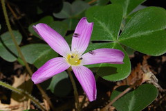
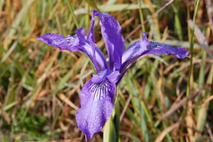
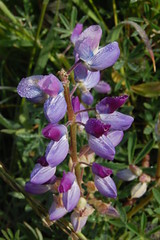
I wasn't thinking of this as a hike that would be good for wildflowers, but there was quite a display. Along the early portion of the trail, there were hundreds of true forget-me-nots (Myosotis scorpioides), as there were back at the campsite. These are tiny groups of blue flowers with five petals and yellow and white centers. They are a little too small for me to get a good photograph of. There were also a few bunches of what I assume must be red columbine:
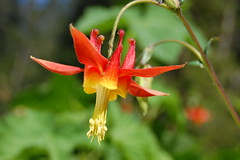
Only they were much larger than any of those flowers I have seen in the Sierra Nevada. I really wished that I had my reflector disc with me to get better lighting on them, but I hadn't planned on this being a wildflower hike, and I left it in the trunk of the car. Instead I used a section of the park brochure that was mostly white to reflect some light on the underside of the flower.
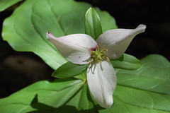
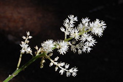
There were several nice examples of western trillium (Trillium ovatum, above) in varying shades of white and purple, and then several other types of flowers I haven't identified, a few of which I photographed:
About 1.75 miles in, the trail reaches a series of "environmental" campsites, which basically means there is no plumbing, just pit toilets. It looked like an even better place to camp than where I was, and I regretted not having gotten one of these campsites that I didn't know about beforehand. There was nobody using any of them on my way out, but one spot was occupied on my return trip.
At one point the trail splits, one way going a short distance along the creek, the other the same short distance up higher, before they meet up again in a large clearing and a junction. This is the end of the old road, at 2.5 miles out, according to a marker. From here you can head to the Pygmy Forest via a fire road for 1.3 miles, or continue along a single track hiking trail through Fern Canyon, reaching the Pygmy Forest in 2.3 miles. I planned to take the trail on the way out, and the fire road on the way back, making for a gentler climb there, but a quicker return.
At one point on this trail, just before I crossed two bridges in quick succession, I saw a man and woman off the trail down by the creek. I looked over at them to see if there was something interesting there, and at that point, the woman pulled down her pants and exposed her bare bottom to me. I'm not sure what that was about, but I just kept on walking as though I hadn't seen anything. I can't promise that you will see anything like that if you take this hike.
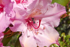
The map shows the trail crossing a small tributary creek, and then Little River, but there were quite a number of small bridges across brooks. Some of them are likely seasonal, but they were running when I was there. After the crossing of Little River, the trail doubles back to the east and starts climbing up the south wall of the canyon steeply. Before long, I could tell I was leaving Fern Canyon behind, as no longer was the soil moist, reddish-brown dirt, but instead it was a dry, gray mixture of gravel and dirt. The tree canopy started to open up, and the trees were much shorter. There were no redwoods here, although there were many lovely rhododendrons in bloom.
I hit the fire road, and turned towards the parking area, and soon hit the self-guided, interpretative trail for the pygmy forest. It's a short loop on a raised wooden platform with side railings and signs explaining what you are seeing. The short and slender trees are fully mature. Trees that at 80 years old grow to 100 feet in good soil, like the Mendocino cypress, may only be 2 feet tall here, although most of the trees were more like 7 feet. It was interesting to read about, but not particularly dramatic to look upon.
Then I started back on the fire road to the junction. I always prefer narrow trails to roads, but this one wasn't bad, especially on the final descent to Little River. I had to jump across it to get back to the junction, as there was no bridge.
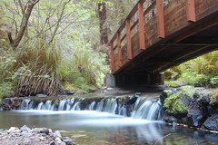
On the way back on the first portion of trail, I stopped to take a long exposure of a tiny waterfall under a bridge, and I read the interpretative signs that I had skipped on the way out, when I wasn't sure how long the total 8.6-mile hike would take me (3 1/2 hours, it turned out). One explained what I saw under the bridge. In the 1930s, the California Conservation Corps had built rock bridges low across the creek, which were quite attractive, and fairly natural looking. But they stopped the salmon from migrating upstream. So they have since been broken apart in the middle, and wooden bridges now arch well above them.
Back at the campground, I hopped in my car and headed up to Ft. Bragg for dinner. One bar and grill that had a menu in the window listed a burger for $12.95, so I decided to skip the historic downtown area, and look for something roadside on the edge of town. I found Jenny's Giant Burger, where I had my dinner.
Afterwards I returned to camp, and started a fire, just so I wouldn't have to turn in early. As it died down, I went to my tent to read some of My First Summer in the Sierra by John Muir. Just after reading how the men in camp would throw themselves down anywhere and use a rock for a pillow, I started my fitful night of sleep in my down sleeping bag on a sleeping bag pad in my tent. I've had chronic back pain for 7 years now, from sitting at a computer all day at work, then sitting at a computer in much of my leisure time. I haven't had a good night's sleep camping since I started camping last year, but the last couple of times have been a little better.
At 5:30 a.m. I started to hear birds irregularly. By 6 a.m., there were calling out to each other nonstop in a great variety of songs, while Little River was, as always, audible as well. I was thinking about a friend and the nature recordings he likes to listen to. Here I was getting to hear the same thing live in concert. But by 6:15 it was light enough that I started getting moving on my day.
After showering, eating breakfast, and packing up, I headed out at 7:15, just as other people were starting to get up--which has been the case every time I've gone camping in the last year. I see people just coming out as I'm driving away. I'd like to sleep more, but I'm glad to be out shooting photos in the early morning light, something I can rarely drag myself out of bed for at home.
I ran up to Ft. Bragg to photograph some things I had noticed the evening before, then started working my way back down the coast. There are brown signs with white lettering everywhere along CA 1 indicating that there is a coastal view at a turnoff, or coastal access. I wanted to see all of them, but I knew I didn't have time to stop at all of them, as I had particular things I wanted to see that day, and I had a long trip back home. I was tempted just to skip all the unplanned ones, but that's not very much like somebody who fancies himself an explorer, so I just arbitrarily chose a few to check out. I'll be back there to try the ones I skipped another time.
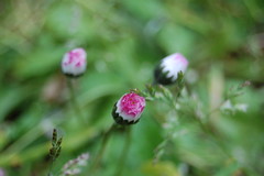
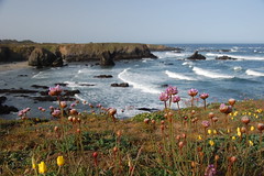
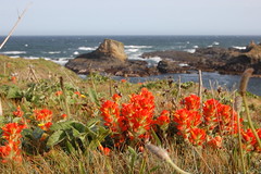
One of the first was marked "coastal view" just on the southern outskirts of Ft. Bragg. There was also an advertising sign there for a restaurant with ocean views and beach access. I turned onto the road and immediately there was a parking area for a trailhead. The trail leads down through trees and clearings where I stopped to take a couple of wildflower shots.
Eventually it came out on some bluffs with an overlook on the ocean. I carefully treaded the narrow pathway that's close to being eroded away onto a piece of land jutting out, and got some more shots there.
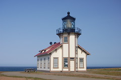
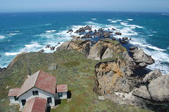
Then I rushed back to the car and headed of to Point Cabrillo Lighthouse. There I parked at a visitor center and marched off on the 1/2 mile walk down a paved road to the lighthouse. The wind was really whipping there, but the sun was shining. The visitor center wasn't open yet, so I just made a quick visit and left.
From there I proceeded to the real reason for my trip, Buckhorn Cove. My mother and her boyfriend had made a trip down the Mendocino Coast a few weeks earlier. They stayed at the Seafoam Lodge, and on the advice of people there, had walked down to Buckhorn Cove at low tide. They saw a sunflower star, which I have only seen once, and have been anxious to see again. They saw something my friend identified from their photo as a yellow bat star, which I have never seen (I've seen plenty of orange ones). And there was a neat sea cave there.
There is no public parking for access to Buckhorn Cove, but I recognized part of it from the photos I had seen on the highway driving by. I figured my best bet was to park just north of it, where there was a small area to pull off the road near a sign indicating a curve with a recommended speed of 35 mph as you are headed southbound, north of Seafoam Lodge, but south of Little River Inn. But I had plenty of time, so first I parked a little farther north at the Littleriver Cemetery, where I was sure I would not be illegally parked.
I parked at the south gate, and there was a path that led straight through the cemetery to an opening in the fence at the back, and a trail behind it. I hoped that would lead to the beach, and I could work my way over to Buckhorn Cove. It led to an area where a sea cave had collapsed and left a gaping whole, with a tunnel that the sea rushes into at high tide, undoubtedly, given the sands at the bottom. There was a steep trail down, with a rope along the way so people can pull themselves up the tough sections. Fascinating. But I didn't venture down.
I kept going and found I couldn't get to the beach or Buckhorn Cove here, so I headed back to the car and parked at the area I had spied before, where there were now two other vehicles parked. I took that as a good sign. There was a pretty clear path along the side of a road down to a guard railing where there were no parking signs. I was alongside an unpainted picket fence with all kinds of no trespassing signs on it. Behind the guard railing, there was a clear trail that I followed right down to Buckhorn Cove.
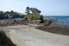
Buckhorn Cove
There was a mass of rocks with tidal pools leading out to what is an island at high tide, but not at low tide. There were also five guys in wetsuits out there, probably abalone fishermen. They all started leaving just after I arrived, which confused me, as I thought it was still about 40 minutes before low tide. I started my explorations.
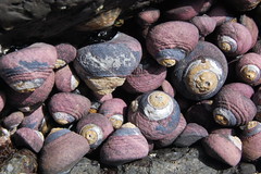
Black Turban Sails
I didn't find much of anything, other than hundreds of black turban snails (Tegula funebralis), until I finally ventured out as close to that island as I could get. I had to climb across wet rocks between tide pools, and step on a lot of rocks covered with surf grass and other plant life. There I saw the sea cave that I recognized from my mother's photo. It was surprisingly colorful inside, but the tide was coming up between me and the cave, so I couldn't get too close. Near here, I found some small bat stars, and I figured that would be the highlight of my tide pool explorations. I searched some other areas, and then headed back to the trail.
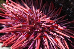
Red Sea Urchin
I had been planning to give up and go back to the car, but checking my watch I saw that it was just reaching the time I expected it to be low tide. Since I had come so far, I ventured out to examine the sea cave area one more time. On the way there I spotted something I had missed before, something I have never seen outside of an aquarium before, a red sea urchin. That would have been worth the return trip. But I was also able to get a little closer to the cave, now that the water was slightly lower, and get a picture inside of it. I was happy with that, even though I still didn't see any sunflower stars. After that I headed back to the car.
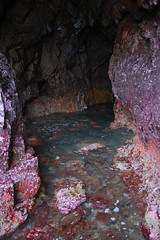
Colorful Cave
After changing clothes (from all the crawling around and lying on wet grass, rocks, and sand, I was quite filthy), I started driving south. I won't go into detail of all my brief stops from here on out, but will limit myself to my two planned destinations, Point Arena and the Sea Ranch Chapel.
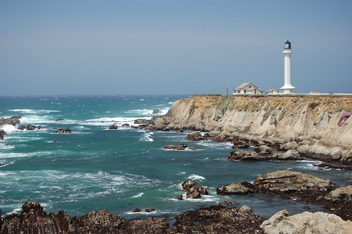
The lighthouse at Point Arena is quite a ways west off of CA 1. The last section of road before the gates to the lighthouse property takes you along dramatic coastline where you can park for free. The most dramatic view of the lighthouse, the shot at the top of this blog entry, is available from the free parking right at that gate. I stopped and took that and many similar pictures on my way back.
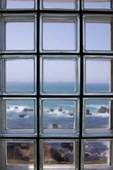
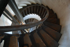
The lighthouse is a commercial operation. They have a tiny museum and a souvenir stand, and charge five dollars to let you walk up to the top of the lighthouse. I went ahead and paid, and quickly took two shots from the top, one out the window, and another of the lens, before heading down again. I took a few more shots on the stairway inside, but I was getting tired, and anxious to go home.
From there I cruised along to Sea Ranch. I stayed at Sea Ranch once, when a friend from Montana who was visiting family rented it out, and invited other old Montana friends who have moved to California to join her there. I had never heard of the place before that. When I got home from that weekend, I checked Flickr for photos of Sea Ranch, and discovered I had missed an amazing chapel. I was really annoyed that I had been that close to it and not had the opportunity to see it with my own eyes.
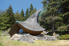
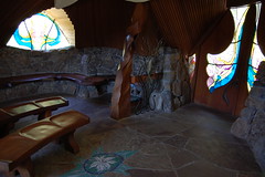
So as I entered the long Sea Ranch area, I kept my eyes peeled on the right (west) side of the road, where all the buildings are. I nearly missed it out in the open on the left side. But I didn't. I stopped and took several photos of the outside, and several on the inside that didn't turn out because I didn't change the ISO setting on my camera. What can I say, I was getting tired.
After that it was a long and wearying drive back to Sacramento, via Guerneville, Sebastopol, Sonoma, and then back onto I-80 at Fairfield. There were many lovely things I passed that would have been worth a stop for a photograph, but all I wanted to do was get home at that point.
5 comments:
Great stuff as usual. I'm usually too busy trying to suck air too remember half the details that you wrote about. I've got to go back there sometime.
Dennis Dixson
Thanks for the gorgeous pictures and info on camping near mendocino. We head there this weekend.
Cool blog on Van Damme Park. I am going tomorrow. I hope that I get as good pics as you did. Thanks for the tips. Wish I read them before I made my reservations.
Thanks for writing thiss
I love that you explored new areas during your trip.
Post a Comment