For this particular day on which my hiking buddy and I were determined to get out, I had hoped to hike on the coast, or to a waterfall in Marin County. But the tide tables indicated it was an inopportune day for a coastal hike, and despite studying a trail map intensively for more than an hour, I could not come up with hike to a waterfall that we hadn't already seen that would be long enough to satisfy me. I'm not going to drive for 2 hours each way to get in a short hike.
Finally I thought of Mt. Diablo. At the end of March, it was about the end of season for seeing Mt. Diablo at its best, blanketed with green grasses and vivid wildflowers. It only takes a week or two of hot weather for the hills to turn golden (or brown, to those who don't appreciate the austere beauty of Northern California in summer).
After Googling, I found the Mt. Diablo Interpretative Association's website, listing hikes by difficulty level. I chose "most difficult," because I'm used to National Forest websites listing anything that is beyond a casual stroll for a family hiking on a whim as "difficult." For regular hikers who plan ahead, these hikes can be quite easy.
But to my surprise, there were some hikes that did indeed sound difficult to me, including the one I recommended to Erik: 17 miles, 3400 feet of climbing. We've done 3400 feet of climbing before, although I was sore for 5 days afterwards. And I've hiked 17 miles on my own before, at Point Reyes. But I've never done anything like the combination of the two (I can't speak for Erik's hiking experience before he started hiking with me).
And this wasn't at the end of an intense hiking period, like September after hiking the Sierras all summer. Neither of us had done attempted a difficult hike since last October. But something about the challenge had me excited. I wasn't sure how Erik would react. But it turns out the hike excited him too, and he thought we should undertake it, unless, as he said, I was only suggesting it as a joke.
No, it wasn't a joke. I set about trying to match up the terse--perhaps absurdly so--directions from the Interpretative Association's website with the trail map in the park's brochure, downloaded from the park's website. But the trail names in the directions didn't always match those on the map. So I just made up some of it from the map, like Back Creek Trail looked nice, with a squiggly blue line running alongside the trail. I wrote it all down on a 3x5 index card (I tried to print out the map, but I need a new ink cartridge). I knew we would have to pay a fee to enter the park, so I hoped there would be a manned kiosk there, and they would give me a trail map.
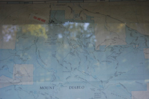
I picked up Erik in the morning and we sped off on the all-too-familiar trip to Contra Costa County via I-80 and I-680. I didn't need any map to find the park entrance on Mitchell Canyon Road, as it wasn't that far east of my uncle's house. There was no kiosk at the entrance, just a place to deposit an envelope with $3 in it. We parked in about the closest space to the trailhead, and after Erik got back from the restroom, we started off. There was a map right at the beginning that I photographed, but there were strong reflections coming off of it, and I was having trouble getting the camera to focus, so I wasn't able to get a shot that would be of much use to us.
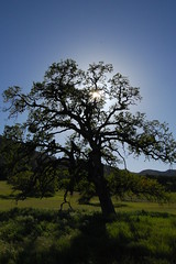
The area at the foot of Mount Diablo is wonderfully bucolic, especially at that time of year. Green grasses, gently undulating land, gnarled oak trees just beginning to bud, a creek running alongside the trail, and wildflowers in bloom--not in mass profusion, but regular enough--all put me in a relaxed and positive frame of mind. There wasn't anything dramatic that forced me to stop and take photographs, but it was . . . pleasant. Even the dramatic mining scar on the hillside to the west of us had its own kind of beauty, suggesting to Erik a terraced landscape. I'm sure we'd both be sick if we knew of the environmental impact of the mining.
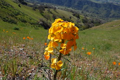
For all of the climbing that was involved, the old Mitchell Canyon Road was gentle at the beginning, and I wondered, out loud, a couple of times about when we would start to climb. That time came, sure enough. We saw a great abundance the wildflower Henderson's shooting star along the trail, but not knowing how long this hike would take, we didn't stop to take photos, even though I've rarely seen this wildflower in the past. Dawdling is a luxury for the descent, when you know you are going to make it back to the car before dark.
A while after we began to climb more steeply, I noticed the 3x5 note card I had written the directions on was no longer with me. I suggested to Erik that he run back and find it, but he was Bartleby-like in his response to that suggestion. Since the heavily trod Bay Area trails are usually well signed and full of people, I didn't worry about it.
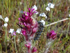
Two women on the way down who saw us laboring on the way up assured us, "You're almost there!" I don't think they knew we were planning to go all the way to the summit, as we were nowhere close to there. We soon reached Deer Flat, 2120 feet, which they must have though was our destination. I did stop to take a photo of a flower there, with a caterpillar on the side of it.
We continued on a dirt road until just before a small parking area for the Diablo Valley Overlook. At that point, a single track trail, Juniper Trail, veered off. At last trail, rather than road. We soon came upon an earnest looking woman, accompanied by two earnest looking men. The woman earnestly informed us that what was before her were owl pellets, and she said something to one of the earnest men about being able to break apart the owl pellets with a stick. I nodded my head and kept marching.
I know my original plan, as derived from the website directions and the map .pdf, had us going to the Diablo Valley Overlook. But I couldn't remember if we went straight up to the lower summit parking lot on a trail on the east side of the lot, or took a more circuitous route to the south to meet up with Summit Trail--both ways are part of Juniper Trail. The latter way looked more interesting to me, so we took it.
It was a decision I soon began to question. Not only would the hike be longer this way, but we were heading downhill gradually--and any elevation we loss would have to be made up when we started climbing to the summit again. But it was a lovely trail with views of the East Bay to the south and east, and of the road to the summit winding through the park. Chemise chaparral densely surround the trail, with the occasional juniper mixed in. We crossed the newly created Trail Through Time, which sounded interesting, and eventually reached Summit Trail.
That's when we started climbing again, and steeply too. This was definitely the most difficult portion of the hike. We went up to the edge of the paved road, then east along a dirt road for access to some utility or something, then climbed up on trail again to Devil's Elbow, where there is a junction with North Peak Trail and a large map.
From there, it was a short, but still steep, climb to the lower summit parking lot.. There was plenty of unused room in this lot. We hiked up the road to the summit until it split into separated lanes of one-way traffic, at which point the summit trail resumes in the space between the two lanes. A dense cover of large shrubs or short trees covered us and blocked the view of cars.
Finally we arrived at the very small parking lot next to the 1930s visitor center. There were people in there cars with the engines idling, spewing greenhouse gases into the air and burning $3.50-per-gallon gasoline, just waiting for a parking space to open up so that they would not have to make the short climb from the lower parking lot.
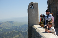
We checked out the view from on top of the visitor center, and went inside of it as well. Just inside the door they have an area exposed in the floor where the true summit of Mt. Diablo is. I checked into buying a map while there, but balked at paying $10.75 for one.
After filling up with water from the drinking fountain, we started making our way back down. We returned to Devil's Elbow where I went over the map and told Erik the plan once we headed off on North Peak Trail, rather than how we had come: left on Prospector's Gap, right on an unnamed fire road, and left on Back Creek Trail.
There were large outcroppings of rock along North Peak Trail, and many more hikers than we had encountered previously. I believe it is part of the popular Grand Loop. At the end of the narrow trail is a saddle and a junction with Prospector's Gap Road. We turned to the left onto that, and passed another junction and another trail map.
Along North Peak Trail
Prospector's Gap Fire Road was quite a surprise because of how steep it was. We were descending at an angle that made it very hard to keep our footing. I told Erik, "I'm going to fall on my ass," and about thirty seconds later made good on that prediction. We both slipped a couple of times after that, but managed to stay on our feet.
The map had indicated that the first junction we would hit would be with the unnamed fire road, but instead we hit a junction with a narrow trail, which threw me. But we continued on. At one point there was a sign indicating Big Springs and an elevation of under 2100 feet, meaning we had already dropped more than 1700 feet. We went over to a creek there for a short while.
The next junction was with Meridian Ridge Road. There, trail signs indicated a distance of 11 miles back to Deer Flat if we continued on Prospector's Gap Fire Road, or a much shorter distance down Meridian Ridge Road to Donner Fire Road.
I wasn't sure what to do--this seemed like where we should be reaching the road to take over to Back Creek Trail. It was, after all, supposed to be the first road we intersected, but I didn't recall seeing that name on it at the map back at Devil's Gap. So we talked about it, and I spent a long time trying to read on my camera's LCD the map that I took the photo of back at the beginning, without any luck. I've mentioned other maps we had passed, but I had not bothered to try to photograph them.
My Lousy Map
Meridian Ridge Road definitely led down and to civilization--we could see houses at a distance, but I was worried because there was still a large ridge between us and the view of mining scars we had seen from where we started out--I didn't want to have to climb over that ridge. But eventually we set off on Meridian Ridge Fire Road.
This road was also extremely steep. While working to keep our footing, we discussed our predicament, and a couple of times Erik told me that he was pretty sure we would make it back this way within a couple of hours, although he also indicated that he couldn't say why he felt that way. At one point we saw two rabbits along the trail, and I asked Erik if that was an auspicious sign. Only the next day did I realize that of course seeing two rabbits on Easter Sunday is an auspicious sign.
A ways down, we could clearly see the end of the mountain up ahead--gently rolling green meadows, followed by suburban tract housing. And then our reassurance came--a junction with a trail and a sign indicating Back Creek Trail was only .59 miles away. As we approached Back Creek, I heard voices--the first people we had encountered in quite some time.
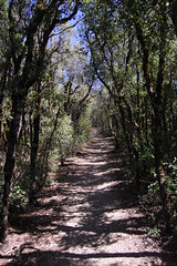
Along Back Creek Trail
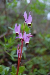
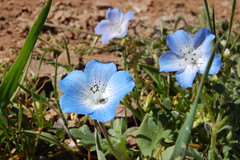
Henderson's Shooting Stars
From then on we had no worries, and could once again take time for photographs. Our only "concern" in getting home was whether we could make it back to the car within 8 hours of having started out, which is what we had guessed the hike would take. Back Creek Trail crosses the creek several times, and late in the day was shadowed by the ridge to the east. The coolness of the shade and the creek were welcome after the steep downgrade on open fire road in the sun.
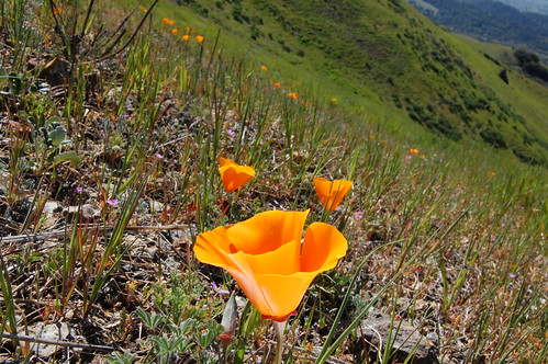
When we got back to a bucolic area much like the one we had started out the hike in, we saw another junction, this one indicating the way back to Mitchell Canyon Road. We headed off on that and ended up later walking in a large, green open space with the occasional oak, on Bruce Lee Road. It went past a large pond, and then ended up just above the Mitchell Canyon Staging Area, where we were parked. We could see a trail down below that led to the parking lot, and it would have been easy to scramble down the hillside to that trail. But there was an area where people had been doing that where branches had been placed to indicate that we should not take that short cut, so we went the long way, hiking to the south past rich outbursts of orange California poppies amongst the green grasses, until we were just a few feet from private houses, where the road doubled back to the parking lot. As we passed where we had been overlooking the parking area from above, we noticed that if we had turned left there, instead of right, we would have immediately hit a switchbacked trail to the parking area.
Near the End
Off the edge of the lot we saw two turkeys, the last interesting part of the hike. We passed a trailer that was a park information center now closed, where I suspect we could have gotten a map in the morning. I asked Erik if it had been open when he passed it to use the bathroom in the morning, and he said he thought it was. Finally, we got back to the car, having completed the hike in under 8 hours: 7 hours and 50 minutes. There was still enough daylight left that I decided to drive back home on CA 160 along the delta for scenic views and light traffic, rather than return on that massive scar, I-80. I'm still not sure exactly how far we hiked, although Erik and I both agree that it couldn't be nearly the 17 miles that we had originally planned on.
2 comments:
Hello. This post is likeable, and your blog is very interesting, congratulations :-). I will add in my blogroll =). If possible gives a last there on my blog, it is about the Câmera Digital, I hope you enjoy. The address is http://camera-fotografica-digital.blogspot.com. A hug.
Thanks for taking the time to detail your hike, most helpful!
Post a Comment