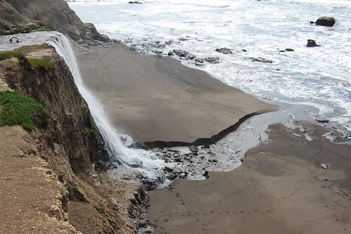
Alamere Falls ranks as one of the great wonders of Northern California--an impressive waterfall that lands on the beach along a rugged scenic coastline, more than 4 miles away from the nearest road or parking lot. It is sights like this that make me so thankful I took up hiking two years ago.
But it's not all that easy to get to, both in terms of driving and hiking. Perhaps there is a faster route there, but it takes me longer to get to the Palomarin trailhead from Sacramento than any other in Point Reyes National Seashore: 2 hours and 45 minutes this time. And then it's a matter of making a long hike planned to reach the falls at low tide, or a shorter hike on a trail the park service signs as dangerous and unmaintained--if one wants to get to the beach below the falls that is.
My friend Erik and I hiked there last year, and wanted to go again this year, but it's a hike that takes patience and planning if you want to be safe and get the best conditions. We waited until there was a weekday (fewer people visiting the falls) with a good chance for some blue in the sky (no forecast is reliable for Point Reyes though) coming after recent enough rains that the falls would be going at close to full force, and then it had to be a day with the low tide at the right time.
Friday, February 29th, was that day. After making the long drive to the Palomarin Trailhead on the south tip of the park (the last bit of the drive is on dirt road), we set out on the trail, with several other people who were setting off about the same time. One of them asked me if this was the trail with the water that poured onto the beach. I don't think he had planned as thoroughly as I had.
My plan was to do as we had done last year--hike all the way to Wildcat Camp (5.3 miles), descend to the beach there just before low tide, walk down the beach to the falls (about a mile), and then return by climbing the crumbling cliff up to the aforementioned unmaintained Alamere Falls Trail. But I also wanted to be sure that our timing with the tides would allow us to return via Wildcat Camp, in case the conditions of the cliff had deteriorated and we could not make the climb up. We both feel more comfortable climbing that cliff, when we can see where the footing is, rather than descending it.
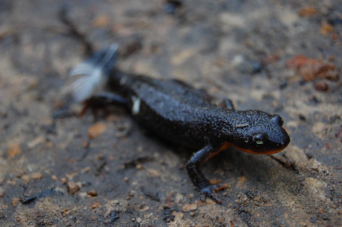
We hiked as quickly as possible, which we needed to do to hit Alamere Falls at low tide. There was no stopping for wildflowers or mushrooms, but we did stop for this critter:
From Palomarin trailhead we followed the same route along Coast Trail that we took last year up to the junction with Ocean Lake Loop (you can read a description in my blog entry on last year's hike). Last year we continued on Coast Trail to Wildcat Camp, but this time we took Ocean Lake Loop, as I'm trying to hike every single mile of trail in the park. The signs indicated this route was only .1 mile longer, while my trail map indicates it is the same distance.
This led us through a marshy area along the coast--oddly, Ocean Lake Loop is closer to the coast than Coast Trail--until we started climbing. At the start of this climb I kept hearing frogs croaking, but I never could find one. At the top of the climb there is a bench, which made me stop to check out the view. From up there I could see Alamere Falls in the distance and a long stretch of beach. That's reason enough to take Ocean Lake Loop rather than Coast Trail for that section of the hike.
We were almost to Wildcat Camp, yet high above the beach, so it was a steep descent from there. I didn't see any people or tents or anything at Wildcat Camp. A deer jumped out of the bushes just ahead of me on the trail as I approached the camp.
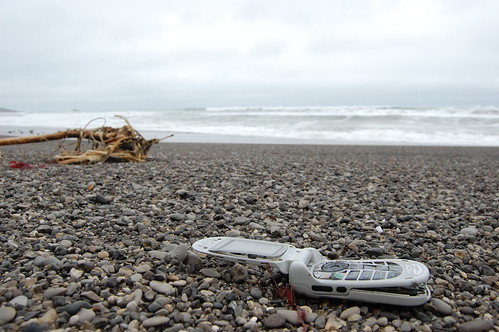
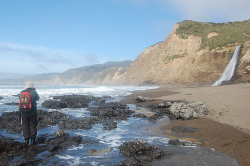
From here we descended to the beach and crossed a stream running into the ocean. Along the beach we got to see all that the last high tide had washed in. It's depressing to see all the garbage littering this gorgeous area. Lots of bottle caps, a cell phone, a very large plastic container of some kind--all sorts of junk. I packed the cell phone out with me, but left the rest--which I often feel guilty about on my hikes.
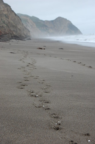
At one point we saw tracks coming down from the cliff, and began speculating on whether somebody had found a shortcut that might be easier than the usual one. But as we got close, we saw they were deer tracks. Farther along we saw strange bits of white matter in the tracks. Closer inspection revealed this to be lots of little bits of styrofoam. I was going to try and find where the deer went back up the cliff, but as we got close to Alamere Falls, I forgot about that, and started taking pictures. During one of the shots, a wave rolled in and washed over the top of my right boot, filling it with water.
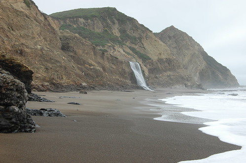
The forecast had been for a sunny day. It had been foggy on much of the drive over. There was lots of blue sky at the start of the hike, but when we reached Alamere Falls, it was 100% overcast, which was disappointing. But still we set out taking all kinds of pictures. Just as I was ready to wind it up, I noticed a couple of streaks of blue in the sky, and we decided to hang around to see what developed. So I took off my right boot and wrung out my sock. We never did get a lot of blue sky, but we got a little more, and set about re-shooting all the same shots we had just taken. During one of these, as I was standing on rocks a little offshore, a wave came in and washed over the top of my right boot again, undoing my attempt to dry out.
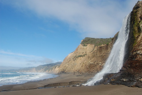
I was ready to move on before Erik, so I went ahead and climbed the cliff and started taking more photos. Alamere Falls is really a series of waterfalls. The largest is the one that drops onto the beach, but there are two smaller ones viewable from a large, mostly flat area halfway up to Alamere Falls Trail. Plus there are nice views of the main falls from above here, although unfortunately the view is into the sun in the afternoon. It was a nice place to eat my sandwich.
After I shot Erik from above and he shot me from below, Erik climbed up. Then a couple arrived from Alamere Falls Trail. The man asked if there was a way down to the beach, so I showed him where we had climbed up. He started down, but the woman didn't like the idea, and eventually prevailed, so they just hung out at that level, as many people do, and I did on my second visit to Alamere Falls (coming from the more distant Five Brooks Trailhead).
I jumped back and forth over the stream a couple of times trying to find new takes on these subjects. Then I climbed up the slope on the south edge of the stream and found my way over to the edge of the falls from there, but wasn't quite able to get far enough out to get a good shot. Erik followed me over, and while he was shooting, I headed up to Alamere Falls Trail--this second climb is safer and easier than the first one. I met a couple up top who thanked me for showing them the way down, and asked if they could get all the way down to the beach, so I pointed out the way and described it to them, and also pointed out the best spot to view the main falls from above.
We were not going to be able to beat rush hour traffic home, especially on a Friday, so after we hiked the short distance back to the Coast Trail we decided to take our time on the way back, and take a side trip to Palomarin Beach, a spur off of the Coast Trail near the Palomarin Trailhead. There were plenty more opportunities for photos on the way back of wildflowers, and occasionally we would stop and get a quick shot, but neither of us was really into it, as we have been on other hikes. I'll wait a few weeks and return to Chimney Rock for wildflower shots.
The junction with the spur to Palomarin Beach is in an enchanting grove of eucalyptus trees. We started off from there and hiked down .6 miles to the beach. Although low tide was a couple of hours past, we were still able to find tidal pools with anemones and some shellfish (I didn't see any sea stars, though). Unfortunately, the water was a bit murky. Erik found the remains of a jellyfish.
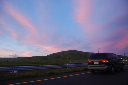
Finally, we made our last climb of the day back up to Coast Trail, and the quick jaunt back to the car, winding up what I would estimate to be an 11.7 mile hike. From there we drove up to Point Reyes Station, to go over to Novato and CA 37 to take us back to I-80 while avoiding as much traffic as possible. But on 37 we hit the heavy traffic, which we were stuck in during a beautiful sunset. It continued slow through Fairfield, but of course it's worth it.
2 comments:
I went to the falls after staying at Wildcat Camp about 20 years ago. The falls was just a trickle. Our night at the camp was interesting. All manner of foxes, coyotes and skunks were prowling around, showing no fear. Apparently they had gotten used to rich pickings from the campers. It was actually scary.
An excellent report from a well-planned hike! Wet shoes are a small price to pay for some excellent photos. We took the unmaintained trail both down to the falls and back with no problems. We missed seeing the tidepools that you described at Palomarin Beach, so we will have to go back there another day to see them.
Coast Trail to Alamere Falls at Point Reyes - BRT Insights.
Post a Comment