
In June of 2006 I made my first ever visits to both the Desolation Wilderness and Point Reyes National Seashore. Now they are my two favorite places on earth, and I have explored them extensively. But until this hike, I had gone more than 5 months without visiting Point Reyes. The summer is the only time for me to hike at the high elevations of the Desolation Wilderness, while Point Reyes can be hiked year round. In fact, it can be at its foggiest and coldest in the summer months.
September and October seem to see the least fog along the coast of Northern California, and I was looking for a hike close to my grandmother's house in the Bay Area where I would be staying the night before, so I decided to make my return to Point Reyes. When I first visited the falls from the beach below back it was in February, when the falls were at full force from winter rains, and I went at low tide so that I could hike down the beach to see the falls from below. But for this day the tide tables showed I would not be able to catch a low tide, so rather than going for open views along the coast and looking for tide pools, I chose to hike mostly through forest, and end up with a view from above of Alamere Falls dropping onto the beach at high tide. My other reason for selecting this route was that I wanted to traverse trails I had not yet hiked, as I plan on hiking every single mile of trail in the park.
With that last goal in mind, I just set off with the trail map in hand from the Five Brooks Trailhead, planning to vary my route out and back so as to see as many trails as possible. The trail from Five Brooks, which is really a dirt road, starts west from just off of CA 1, quickly passing a junction with the Rift Zone Trail on the right and a pond with a picnic table next to it on the left.
1.6 miles from Five Brooks Trailhead on Stewart Trail to Greenpicker Trail
I made the slight ascent to the junction with Stewart Trail (again a dirt road, one that is better maintained than several I have driven on to reach a trailhead) and turned right and started a winding route uphill with the sounds of traffic on the highway breaking through the heavy forest At first I could glimpse stables and farm buildings occasionally through the trees, but soon I left that behind, and it was just more trees and ferns on the slopes below and above.
2.0 miles on Greenpicker Trail to Fir Top
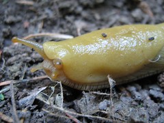
At the junction with Greenpicker Trail, there was a warning sign indicating "Yellow jackets have been aggressive on this trail." Leaving the dirt road behind, I climbed what was mostly a narrow footpath, although some parts were a bit wider. At one point I heard branches breaking in the brush and stopped to see if I could spot what was making the noise, figuring that it was probably a deer. But every time I stopped, so did whatever was making the noise, and I never did see it. I did, however, spot a banana slug crawling across the trail later on.
When I came to the next junction, the continuance of Greenpicker Trail was blocked off, with a sign indicating that it was closed for fire concerns, which seemed odd, since we have already had some rain this fall. So instead I just followed the obvious, although unsigned, path back to Stewart Trail, which was quite close.
.3 miles on Stewart Trail to junction with Ridge Trail
Back on Stewart Trail, I immediately spotted a sign indicating this was Fir Top, elevation 1324 feet, the high point of my climb. There were areas around that were obviously a couple of feet higher than the place where the sign was planted, so that isn't the true high point, but it's not like there is a peak or summit. Still, it was a decent climb to get there of just a little over 1200 feet.
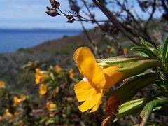
Also near the junction were two clearings covered with dried grass, but also bright golden-yellow flowers that appeared much like dandelions.
.1 miles on Ridge Trail to Alamea Trail
The junction with Ridge Trail was a surprise, because there is a junction much earlier on Stewart Trail with the same trail that I have taken before when I hiked most of Ridge Trail before. It took me the short distance to Alamea Trail.
1.5 miles on Alamea Trail to Old Out Road
Alamea Trail is a narrow footpath with a view down a steep slope into a surprisingly deep valley, all choked with greenery of all kinds. I did some descending and some climbing along this trail before reaching Old Out Road.
1.1 miles on Old Out Road to Coast Trail
There are still working ranches out in Point Reyes, but there used to be even more before it was made into a national park, and there are old roads and ranch sites that are slowing returning to their natural state. This old road has been made into a single-track trail, but the rest of the old road is now mostly grass, rather than bushes and trees, leaving a fairly wide tree break. As the trail gets steep near the descent to Coast Trail, some patches resemble a wide dirt road more than a hiking trail.
.4 miles on Coast Trail to Alamere Falls Trail
Once on the Coast Trail I was on familiar ground, having hiked this way to Wildcat Camp from the Palomarin Trailhead in order to get down to the beach to walk back to Alamere Falls. But I headed away from Wildcat Camp this time, and back towards the trail that leads to the top of the falls. Much of the Coast Trail follows an old road, and on occasion small patches of pavement can still be spotted.
Ocean Lake Loop soon merged onto Coast Trail, and I saw two backpackers coming along that trail, the first people I saw that day. I rounded a bend and got my first view of the ocean that day, with the Farallon Islands visible in the distance. While my forecast had been for partly sunny skies, it had been sunny all day, with just a few clouds beginning to form over the ocean at that point. It was the most blue I have seen the skies at Point Reyes, and I really wish I had chosen a hike with more open views of the dramatic coastline.
There were many wildflowers along the trail. It wasn't quite the riotous explosion of color that I saw on Chimney Rock Trail in April, but still nice to see this time of year. There were many bush monkey flowers, and a few California poppies, cobweb thistles, and bindweed.
I crossed Alamere Creek, and was glad to see it was flowing. It wasn't a torrent, but it was more than the trickle I had seen at Muir Woods a few weeks earlier. Past that the trail went through a large clearing, with another clearing visible behind some trees. A clearing near a creek and a point of coast access suggests to me that this was the site of a former ranch house.
.4 miles on Alamere Falls Trail to Alamere Falls
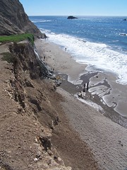
A sign at this junction indicates the trail is unmaintained and dangerous, but I had been this way before, knew the dangerous portion, and didn't plan on doing that part this time. I hiked along a narrow path that is a trench at points, with thick vegetation brushing up against me much of the way. I got to the end of the trail, passing some faded seaside daisies, and there were plenty of people there.
The trail ends up at a short drop-off where rain and hikers have worn a path through the dirt. I went down, using my hands where the footing wasn't entirely secure, as I was only wearing sneakers, rather than my hiking boots. The other people followed me.
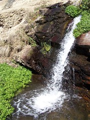
Once down there, it was an easy step across the creek right at the point of its second, and smallest, drop, with common monkey flowers blooming right at the water's edge. When I hiked back this way with my friend Erik on our way back last February, this portion couldn't be crossed, and we had to leap across the stream down below.
I went down to the edge of the cliff above the beach and looked over towards the main waterfall and was disappointed to see that I couldn't see much of it. In February the volume of water was great enough that it was shooting off the cliff a ways, but this time it was just dropping straight off the edge.
After observing one tiny ice plant, I went back to the stream, filled with greenery that completely covered it at points, to take some pictures. I had to be patient, as people kept crossing the creek and posing for pictures next to it. Some couple kept taking pictures in the bright sunshine of things at a great distance, and the flash was firing every time.
Then I went back and got what picture I could of Alamere Falls from the side, but by this time people had made the precarious descent down the crumbling cliff to the beach and were roaming all about it.
Finally, I headed back upstream and climbed back to the first plunge pool and second highest drop. I'm not sure if anybody else noticed it was there. I had it to myself. This waterfall was all in shade, which gave me the perfect opportunity for a long exposure, although I hadn't brought my Gorillapod. Using a tip from my cousin Tim, I set my camera on my backpack, which allowed me to adjust the angle of it and then leave it there on a timer to take the picture (see the picture at the top of this entry).
I didn't stay long. It had gotten a late start in the morning, and the 7.4-mile hike with more than 1200 feet of climbing had taken me some time, and I had 7.2 miles to go on the return hike before driving home to Sacramento, so I took off.
.4 Miles on Alamere Falls Trail to Coast Trail
.4 miles on Coast Trail to Old Out Road
1.4 miles on Old Out Road to Stewart Trail
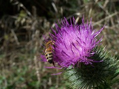
Instead of following Alamea Trail back the way I had come, I just continued on Old Out Road to Stewart Trail. Past the junction with Alamea, the trail showed large portions of old pavement. Along here I spotted some yellow jackets in cobweb thistles. They let me get closer than I expected, seeming to be wholly immersed in their business with the flowers. Only when one flew up quickly and hit against my face did I recall the warning about aggressive yellow jackets, and I started off down the trail again.
5.0 miles on Stewart Trail to Five Brooks Trailhead
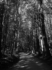
Stewart Trail
I was hoping that taking a more direct route back, I would cut the distance significantly, so when I reached Stewart Trail, I was disappointed to see that it was a full five miles back to the trailhead. The first .9 miles of this was a steep climb up to Fir Top, then it was all downhill. I went as quickly as I could manage, and did pretty well considering the round trip ended up at about 14.6 miles with 2500 feet of climbing (remember that on the return I had to climb from just above sea level at Alamere Falls back over 1324-foot Fir Top), all without any food since breakfast. I ended up being quite tired and sore at the end. I had thought that wearing sneakers would make it easier on my feet, but it had been some time since my feet were that sore after a hike. As always, though, it was rewarding, and I felt satisfied over the final mile of the hike.
[For descriptions of the hike from Palomarin Trailhead to the beach below the falls, see my hike reports on Alamere Falls from February 2007 and February 2008.]
Hike Summary
Date: 30 September 2007
Trailhead: Five Brooks
Approximate distance: 14.6 miles
Links: Point Reyes National Seashore, Maps
2 comments:
your photos are very beautiful, detailed and true to the feeling of the subjects. great work.
Wow, that is a smorgasborg of trails that you hiked! I added your trip report on Point Reyes National Seashore hiking trails - SF Wiki.
Post a Comment