Some of my photos are now for sale at ImageKind.

Nature Index
(My hiking and camping adventures in Northern California.)

Culture Index
(NorCal cities, highways, restaurants, museums, architecture, historic attractions, vintage neon signs, roadside attractions, etc.)
Showing posts with label vintage neon. Show all posts

Friday, July 6, 2012

Lost Neon Sign: Martinez's State Theatre

20120612 State Theatre

This is my second attempt at this blog entry on the giant, crumpled neon sign in the parking lot of the Warehouse Cafe in Port Costa. It says "STATE" on it, with the "ATE" on one side of the bent-in-half sign, and the "ST" on the other. In searching for where it might have come from, I stumbled upon a small photo online of the old sign for the Golden State Theatre in Monterey, which for a time just went by "State Theatre," and no longer has its neon. They looked the same, and I posted a blog entry, but it was a very small image.

I later was able to find a better image, and see that the "A"s did not match. Plus, I had someone point out my error in a comment on my blog, and another in a comment on my Flickr photo. The latter also led me to the real identity of the sign: it came from the State Theatre in Martinez. That does make much more sense for hauling that giant sign to Port Costa, which is right in between Martinez and Crockett.

According to the information posted on the Cinema Treasures entry for the State Theatre, it was built in 1926, but remodeled in 1932 after a fire a year earlier. I would guess that the sign dates from 1932. Here's a photo of the theater with the sign on it all lit up, from 1942.

So how did the sign end up in Port Costa? The sign likely came down sometime in the 1960s. The theater stopped regular operation in 1961, but reopened briefly at least a couple of times after that. And it would have made perfect sense for Bill Rich to have brought it to Port Costa then.

Bill Rich, according to a San Francisco Chronicle article, bought much of historic Port Costa in 1960, the year after the railroad closed its switching yard and roundabout there, removing the town's last economic reason for existing. Rich filled the Warehouse Cafe and the Burlington Hotel with "antiques and oddities," including quite a bit of architectural salvage and a giant stuffed polar bear, which decorate the Warehouse Cafe.

20080329 Warehouse Cafe
Warehouse Cafe Interior

But then there's this entry on the Cinema Treasures listing:

In the mid-seventies, I worked for a woman who had the original marquee. I recently (Dec 2007) went back to the Bay Area for Christmas and drove by where the woman stored it. Oh my God!!! The marquee is still there!

And I don't remember seeing the sign in Port Costa when I went there to eat at the Warehouse Cafe in March of 2008.

But there are photos of the sign labeled as being in Port Costa taken in 2005 and 2006 on Flickr. Unfortunately, those are close-ups of detail, and don't give any clue as to the exact location. Maybe it was just tucked away somewhere in Port Costa.

I welcome any additional information!

Oh, and here's the Martinez Historical Society's page on the theater.

Thursday, March 8, 2012

Lost Neon Sign: Sacramento's Philipp's Bakery

20070426 Philipp's Bakery

Not really lost. Just disappeared from public view, into the warehouse on the old McClellan Air Force Base where the Center for Sacramento History stores its large collection (more than 30) of vintage neon signs, including those from the original Shakey's Pizza on J Street in East Sacramento, and the Rosemount Grill, the bakery's former neighbor. I think they also have the Ark of the Covenant in there, but who really cares about that? THEY'VE GOT MORE THAN 30 VINTAGE NEON SIGNS!!! (I'm an enthusiast.)

New Off-Site Storage Facility #10
[This photo, from the Center for Sacramento History's Flickr account, shows them moving signs into the warehouse.]

According to an article by Lance Armstrong (presumably not the famed cyclist enjoying an encore career as a local interest writer), German immigrants Julius Herman and Angelina Philipp first opened their bakery in Calistoga, then moved to East Sacramento in 1925.

Besides the fact that the bakery was a longstanding institution in East Sacramento, the sign for it was a notable landmark on the old alignment of U.S. Route 50, pre-freeway. You can read more about the vintage remainders of this section of the old highway in my blog entry on Sacramento's Folsom Boulevard.

In 2007, I met the a man who claimed to be the owner of the building while taking the photo below. He was a broker who had returned to Sacramento and told me he had been very excited to be able to purchase his father's bakery and that his wife was running it now. He gave me his and his wife's cards and asked me to e-mail him a photo from that night. I did, but never got a response.

20070426 Philipp's Bakery

He told me that he had the sign restored (by Pacific Neon) in place, as he was afraid if it were taken down the city would not let him put it back up again. During the restoration process, it was discovered that the sign was a flasher, which he did not recall as a kid. He found out why. It was restored as a flasher, and a part kept burning out that had to be replaced for a couple of hundred dollars regularly. He figured his father had simply wired it to stay lit continually so as to avoid the expense.

Shortly after this conversation, I was surprised to learn that the bakery had closed, and a blog on the Sacramento Bee's website indicated that the brothers who owned the building had refused to renegotiate the lease of the baker and instead evicted her. Strange situation if said baker was the wife of one of the brothers.

20040824 Philipp's Bakery

Sorry to see the lovely old sign leave the neighborhood, particularly since I haven't photographed it since I upgraded from a compact digital camera to an SLR in 2008. I have been meaning in recent months to reshoot it, but once again I failed to act in time. Hopefully the Center for Sacramento History will let the people get another glimpse of it. Preferably sometime before their big Ark of the Covenant of show.

Wednesday, October 28, 2009

U.S. Route 40: Reno's 4th Street

The historic U.S. Route 40, and before it the even-more-historic Lincoln Highway ran through the heart of Reno and Sparks, along 4th Street in Reno, and apparently both along Victorian Avenue and Prater Way in Sparks, as both streets are marked with Lincoln Highway markers after they split off from one another.

Many businesses arose along the route to take advantage of the highway traffic. When the freeway, current Interstate 80, was built, I believe in the early 1970s, these businesses were bypassed. Many have disappeared all together, the remnants of some remain, others struggle to stay in business, and a few flourish.

This is my journey down the old highway route, from west to east. I haven't had the chance to do much research on the subjects yet, and my photographs are for the present heavily sign-oriented. I hope to get a wider variety of photos next spring when I next plan to visit Reno.

20091021 Lincoln Highway Bridge Rail
Lincoln Highway Bridge Rails

When I went to Reno in 2003, there must have been some sort of sign indicating there was a site of historic interest that led me to pull off of Interstate 80 just west of Reno and photograph these old bridge rails from the Lincoln Highway. I found them in 2009 only because I remembered to look for them--the turn off on east-bound I-80 is only marked as "TRUCK PARKING."

A sign there indicates that the rails were originally located .9 miles to the east, where they were installed in 1914 by contractor A.F. Neidt.

20091022 Mineral Inn Spa & Resort
Mineral Inn Spa & Resort

Shortly after the bridge rails headed east on I-80, there is a turn off for West 4th St.--that is the old U.S. 40 route. Immediately upon exiting you are faced with the sprawling remains of an old resort, now fenced off with no trespassing signs. I found a way to get in, but respected the signs. But if you are curious what the grounds look like, here are some photos from somebody else.

The route into downtown Reno from here is quite scenic, following the Truckee River, which was lined with trees in full fall foliage when I made the trip in October. On the outskirts of town you hit what remains of the old motel row.

20090927 Silver Spur Motel
Silver Spur Motel

It didn't appear that there is a motel operating there, and I could not find a listing for the Silver Spur.

20090927 Washoe Steakhouse
4201 W. 4th
Washoe Steakhouse

Looked like a very nice restaurant.

20090927 Tombstone Territory
2255 W. 4th St.
Tombstone Territory

The name of this motel derives from its proximity to a cemetery.

20090927 Sunset Motel
2091 W. 4th St.
Sunset Motel

20090927 El Tavern Motel
1801 W. 4th St.
El Tavern Motel

20090927 Silver State Lodge
1791 W. 4th St.
Silver State Lodge

There is no motel to go with the sign anymore, but here is a description of the place from an old postcard:

Reno' Finest Motor Court
* Steam Heated Rustic Cottages
*Complete Electric Kitchens
*Free Steam Heated Garages
*Six Acres Beautifully Landscaped
R.J Reynolds, Owner - W.D. Crawford, Mgr.

20090927 Gold 'N' Silver Inn Restaurant
790 W. 4th St.
Gold 'N' Silver Inn Restaurant

In business since 1956. I've eaten there twice now. The eggs Castroville--eggs Benedict with artichoke hearts in place of Canadian bacon, were particularly good, but I didn't get a photo of that. You'll have to settle for a photo of meatloaf.

20091022 Meat Loaf

20090927 Donner Inn
720 W. 4th
Donner Inn

20090927 Chapel of the Bells
700 W. 4th St.
Chapel of the Bells

20091022 Crest Inn
525 W. 4th St.
Crest Inn

Not much of a sign, but the design of the building is a nice example of Googie.

20090928 Rancho Sierra
411 W. 4th
Rancho Sierra Motel


280 W. 4th St.
Lido Inn

20090927 In-Town Motel
260 W. 4th St.
In Town Motel

20091021 In-Town Motel

215 W. 4th St.
Bonanza Inn


200 W. 4th
Mardis Gras Motor Lodge

After this we pass through the heart of downtown Reno, N. Sierra, N. Virginia, and N. Center. Virginia Street is the old U.S. Route 395 route, pre-freeway, and is still Business 395. Along it the largest downtown casinos are located, particularly Circus Circus, The Silver Legacy, and El Dorado, which all flow into one another at the 2nd floor level, bridging the streets below and making one enormous indoor casino, restaurant, and bar space.

20090927 Louis Basque Corner
301 E. 4th St.
Louis Basque Corner

20091022 N.C.O. Railroad Station
325 E. 4th St.
Nevada-California-Oregon Railroad Station

20090927 Morris Hotel
400 E. 4th St.
Morris Hotel

20090927 Abby's HWY 40
424 E. 4th St.
Abby's Highway 40

20091022 Flanigan Square
701 E. 4th St.
Flanigan Square

Built in 1902.

777 E. 4th St.
Rancho 777

20090927 Lucky Motel
1011 E. 4th St.
Lucky Motel

20090927 Alturas Bar & Nightclub
1044 E. 4th St.
Alturas Bar & Nightclub

20090927 Brought to you by the number . . .
1113 E. 4th St.
Reno 8 Motel


1200 E. 4th St.
Sutro Motel

20090927 Hi Ho Motor Lodge
1233 E. 4th St.
Hi Ho Motor Lodge

301 Montello St.
Ernie's/Reno Salvage Co.

On the south side of the 1300 block on E. 4th St., just approaching Montello, there are a couple of beautiful art deco structures behind chained link fencing. Both the names Ernie's and Reno Auto Salvage can be seen.

20090927 Ponderosa Lodge
1400 E. 4th St.
Ponderosa Lodge

20090927 Desert Sunset Motel
1425 E. 4th St.
Desert Sunset Motel

20090927 Tahoe Motel
1650 E. 4th St.
Tahoe Motel

20090927 Hi-Way 40 Motel
1750 E. 4th St.
Hi-Way 40 Motel


1752 E. 4th St.
Farris Motel

One of the buildings for this motel has a really interesting rounded, staggered corner, but I haven't gotten a photograph of it yet.

20090927 Sandman Motel
1755 E. 4th St.
Sandman Motel

If I had to choose a favorite sign in Reno, this would be it.

20090927 Sandman Motel

20090927 Everybody's Inn Motel
1756 E. 4th St.
Everybody's Inn Motel

20090927 Gold Coin Motel
2255 E. 4th St.
Gold Coin Motel

I'm a little confused by this place, as the coin they chose to make golden is a silver dollar.

20090927 Casale's Halfway Club
2501 E. 4th St.
Casale's Halfway Club

20090927 Restwell Court
2525 E. 4th St.
Restwell Court

On February 18, 1979, three units were destroyed by fire at the Restwell Court Motel. It probably didn't last much longer than that and there is no motel building there today.

Then we cross over into Sparks.

20091022 Coney Island Bar
2644 Prater Way
Coney Island Bar

Opened in 1935, and named after an amusement park that used to stand across the street.

Prater Way & Victorian Ave. split.


2406 Prater Way
Pony Express Lodge

20091021 Copenhagen Bar
2140 Prater Way
Copenhagen Bar

20090928 the Elbow ROOM
2002 Victorian Ave.
Elbow Room Bar

20090927 Elbow Room Bar


19th & Prater Way
Ideal Shopping Center

20091021 Ideal Shopping Center


1861 Victorian Ave
Craig Motel

20091021 Tarry Motel
1828 Victorian Ave.
Tarry Motel


1800 Victorian Ave.
Safari Motel

20091021 Playhouse
1746 Victorian Ave.
Playhouse Lounge

Monday, August 3, 2009

The Vintage Neon Signs of Marysville & Yuba City

(and the rest of Yuba County & Sutter County)

Marysville and Yuba City are these days essentially one city, but they are separated by the Feather River, and when drawing up counties for California, the Feather River was made the border between Sutter and Yuba Counties. And just to make it a little confusing, Marysville, bordered on the south by the Yuba River, is the seat of Yuba County, while Yuba City is the seat of Sutter County. In the 2000 census, Sutter County was home to 78,930 people, while Yuba County had a population of 60,219. Given that the sparse population of these two counties is mostly centered in this urban area right on the border, the area is often referred to as Yuba Sutter, and they have one combined county fair called the Yuba Sutter Fair.

Both cities are on the historic path of U.S. Route 99E. U.S. 99W went from Sacramento to Davis, then Woodland, and from there generally followed the route of current Interstate 5. U.S. 99E went from Sacramento to Roseville, then followed the path of current CA-65 through Lincoln and Wheatland on its way to Marysville. It crossed over to Yuba City--I'm not sure if that would be on current CA-20, or farther south on Bridge St. Leaving Yuba City, it headed north on current CA-99 to meet up with U.S. 99W in Red Bluff. The current CA-99 stretch from the junction with I-5 near the Sacramento Airport to Yuba City is not the historic route of the federal Highway 99.

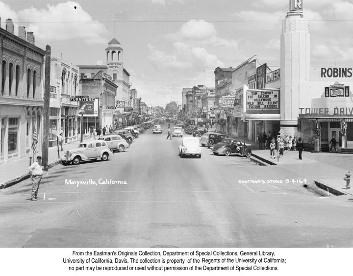
A 1950s postcard that I bought at Red Tire Antiques in Yuba City shows the streets of downtown Marysville lined with dozens of neon signs. Not one in the picture remains today, and many of the buildings are gone too. When I visited Marysville and Yuba City for the first time in 2000, the Sutter Theatre in Yuba City was still open, as was the Marysville Drive-In (actually across the Yuba River from Marysville in Linda or Olivehurst). The State Theatre had just closed a year earlier. Now the Sutter is in the process of being converted to a performing arts center, the drive-in is just a rubble and weed-strewn parking lot, and State Theatre has now been closed for a full decade.

But here are the signs I managed to get to with a camera before they were destroyed. If you know of any that I have missed, please drop me a line (check my profile for my e-mail).

Marysville, Yuba County

20090801 Plaza
232 1st St.
Plaza

This sign was my most recent discovery in the area. The address is now the site of the Chinese Museum of Northern California, opened the first Saturday of each month.

20060702 Quick's Glass Service
520 3rd St.
Quick's Glass Service

I'd guess that this mixed plastic and neon sign dates from the 1960s.

20080906 Cortez Room
315 5th St
Cortez Room
20051219 Cortez Room

20051219 Cottons Cowboy Corral
320 5th St
Cotton's Cowboy Corral

20051219 Matthews Music
425 5th St.
Matthews Music

I'm guessing that this isn't vintage, but it has the right look, and it could be vintage, so for now I'll keep it in this list.

20090613 Bossen Bros. Laundry
221 B St.
Bossen Laundry

In the 1947 city directory, this business is advertised as the "Wife Saving Station."

20090801 Travelers Hotel
229-231 C St.
Travelers Hotel

The hotel was built in 1912. The neon must have come later, since neon tubes were not used for commercial signage until the 1920s.

20001104 Tower Theater
103 D Street
Tower Theatre

I believe this theater was built as the Liberty Theatre, and then remodeled to become the Tower Theatre. The Liberty, which opened on January 11, 1927, was built on the site of the National Theatre, which burned down on January 28, 1926. (A new National Theatre was built on E Street, which then was later remodeled to become the State Theatre, which still stands, but without its original neon marquee.) The Tower Theatre opened at the same site as the Liberty on January 17, 1941, and like the Liberty, its advertising logo was "The Family Theater."

The shot above is how I first saw it in 2000. The shot below is how it appears now--the theater space has been converted to offices, but the marquee remains, as well as the terrazzo floor. Here's a lovely image of the place in full swing back in the day.
20080906 The Former Tower Theatre

20080810 Mogheli's Furniture
530 E St.
Mogheli's Furniture

I'm not sure about this sign. The design certainly looks vintage, but I don't remember seeing it in my early visits to Marysville. But it may have just been moved--I found a listing for Mogheli's at 430 D. St.

20080810 Bob's Lock & Key Shop
509 G St
Bob's Lock & Key
20051219 Bob's Lock & Key Shop

20090704 The Walnut Tree
North of Marysville on CA-70 at Ramirez Rd.
The Walnut Tree


Yuba City, Sutter County

20080906 Sutter Orchard Supply
573 Bridge St.
Sutter Orchard Supply

20080906 Westbridge Village
Bridge St.
Westbridge Village

20001104 Hal's Grubstake
440 Colusa Ave
2000 Hal's Grubstake

It was in business when I first visited the area, and I ate one of their Dude Burgers. Now one sign is gone entirely, and the other has been drastically modified and has no neon.
20001104 Hal's Grubstake

20080906 Liquor & Deli
724 Colusa Ave
EZ Bentprob Liquor & Deli

With a name like that, it has to be good.

20080810 Sutter
754 Plumas St
Sutter Theatre

Below is all the neon that was working on it in 2005 when it was still operating as Sutter Cinema 3.
20051219 Sutter Cinema 3

20080810 Spur The
758 Plumas St
The Spur

Below is all that was lit when I checked it in 2005. Since then I have never seen any part of it lit.
20051219 The Spur

20080810 Town Pump
760 Plumas St
Town Pump

In the 1970 Yellow Pages they advertise, "Cook Your Own Steak to Your Liking." Man, I can do that at home.
20090814 Town Pump

Linda, Yuba County

20090801 Anton's Apartment Motel
Riverside Dr.
Anton's Apartment Motel

This sign was quite a discovery for me. It certainly didn't seem like an area that would have an old neon sign, and I'm not even sure why I was on that road, but I happened onto this rusting beauty in a fenced-off vacant lot


Live Oak, Sutter County

20010414 Pasquini's
6241 Live Oak Blvd.
Pasquini's

20080818 Liquors
Liquor Store

I'll have to get the name and address (and hopefully a better picture) next time I'm in Live Oak.